-
Posts
1,432 -
Joined
-
Last visited
Content Type
Profiles
Blogs
Forums
American Weather
Media Demo
Store
Gallery
Posts posted by Burghblizz
-
-
When the bad outlier for PIT is 7”, I’ll take it. It does really show the worst case scenario though for Fayette and Westmoreland
(talking NAM)
-
23 minutes ago, TimB84 said:
Not sure the RAP is worth anything, but the 9z run had 22” at PIT.
It’s good if you want to see if a you have some good rates in the next few hours - but I wouldn’t look at totals 30 hours before the storm.
-
GFS looking nice and robust still at 18Z
-
10 minutes ago, MAG5035 said:
I do feel the same way, but I don’t completely discount the NAM’s robust warming higher up near the 850mb level either. But same stuff as 12z. The money 3hr frames for ZR are 60 and 63. Using my nearest station at KAOO as an example since I’m in the thick of the heavy ZR over here.
HR 60: Surface -6ºC, 925mb (~3k ft) -6ºC, 850mb +2ºC
HR 63: Surface -2ºC, 925mb -3ºC. 850mb back to 0ºC
Even with that basic breakdown at the major layers I look at that and ask what part of that suggests that particular station sees 0.78” as freezing rain? I think something toward a NAM scenario might get a few hours of sleet into the central and *maybe* western counties. But Pitt’s advantage is the 850 low tracks favorably on the NAM for western (and serviceable to central counties) plus overall flow is on the cold conveyor belt side of the low. We don’t have an Ohio Valley low with SW flow intruding in this situation and trying to overcome that with a secondary to the coast. The warm advection comes from the tremendous easterly flow aloft with the coastal low. I can’t really think of a situation in the past that has presented the NAM type scenario of that much mix/ZR into western PA so that would be a new one to me if it happened.
Thanks for your thoughts. He was weenying out a bit
-
 1
1
-
-
13 minutes ago, KPITSnow said:
The 18z NAM is a clown show lol
If you are looking for a trend, it’s snowier than 12Z. Fills in a wider swath of 6”+ and gets that 12+ tail closer from the NW.
Sure, Its the worst model for us still, but it’s better than it was.
-
 3
3
-
-
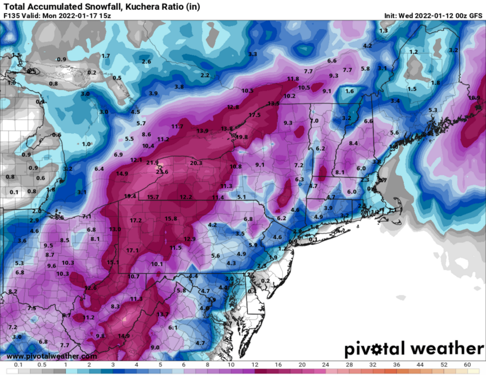
GFS looks fine. 12-15” city and points North and West. More mixing south and east, but still warning snows there too before any crap. That 119 corridor looks most susceptible.
Seems to extend the backend a little too. A post storm snow globe day Monday would hit the spot.
-
NAM likely isn’t right. Mid level low is far enough SE that it’s not going to flood like that. If it does, we are going to have a helluva snow cone Monday Morning.
-
 1
1
-
-
1 hour ago, MikeB_01 said:
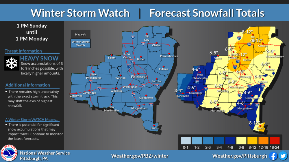
This morning Harbaugh had a map showing 5-9 covering the majority of the area. A pocket of 9-12 north of AGC and a 3-5 area south of westmoreland where he thinks mixing will occur.
.Sounds pretty fair
-
3 minutes ago, SteelCity87 said:
Curious which model they're basing that off of
Probably a blend as it’s their actual forecast. That heavier band N/NW has been consistently showing up as as some of mixing/slotting. Just depends on where that all lands.
-
-
My takeaway from the NAM is juicier.
Puts some big totals north and west of the city, and somehow has a little bullseye of .50 freezing rain over my house (but not north, south, east or west)
Not sure if that’s a function of it struggling at long range, or picking up on something. My guess is that there some brief warming from the inland low, and the totals differ based on the how much QPF there is during that period. So it looks wonky.
I hope we have a nice fat swath of straight snow by tommorow.
-
Mesoscale modes aren’t going to do great with mesoscale features at hour 84
-
 1
1
-
-
Just now, TimB84 said:
EC largely held serve. Just a hair east.
Yeah it’s fine. Slightly Different evolution and the heavy banding is bouncing around. So it’s location specific output might look a little less.
-
5 minutes ago, Mailman said:
GFS looks good.
Lots of details to be worked out - but I love that look of a captured /retrograding storm. Puts accumulating snow well into Monday.
-
 1
1
-
-
6 minutes ago, Mailman said:
Jan '94 mixed in Morgantown, but not in PA, right?
I don’t recall anyone mixing. Greene and Fayette counties got drilled. 30” lollipops.
-
EURO more WEST. Sneaking a leak (and a peek) in a meeting, but I think it’s output is going to be nice (esp city and east)
-
 1
1
-
-
7 minutes ago, Ecanem said:
GFS 12Z rolling in is looking closer to 00Z looks a little stronger on the 500mb too. Let's see where it goes.
Stronger and maybe a little dicey for the Mon Valley. North of city looks great. Still good run IMO since there is some “too far east” leaning guidance out there too
-
-
Roads are getting bad pretty quickly.
I could see places in the Mon/Yough valley pulling out 4” or 5”
-
Crazy that last year we already had a double digit storm in the books, and was knocking on the door of our 3rd 6”er.
On the bright side - hasn’t been any stress or disappointment yet. But I’m more than ready for it
-
3 hours ago, CoraopolisWx said:
Looking at the traffic cams, the solid accumulation has been mostly above 1100ft.
1.6” officially. Mostly wet in the city. Impressive for 4.21!
-
On 3/14/2021 at 8:35 PM, Ahoff said:
Just the way it goes. Good thing we got 55” over the winter.
I like the way the snow came too. Nice big chunks. So maybe we didn’t hit prodigious season totals since the ending fizzled, but enjoyable.
(I bet we do add something to that total, just not counting on anything that changes the overall winter assessment)
-
RIP Bob Kudzma
Fun fact is that he drove a bus for 18 years after he retired on the air. Just something he said was his dream as a kid. Seems like he was a good guy.
Growing up he was like the NAM with the juiced up totals, and Denardo as like the Euro (except this yr) telling us not so fast. He used to say that he forcasted to prepare people.
Throw Bowman in there and it was quite a nice local met dynamic. Definitely appointment TV to get their forcasts after tracking a storm on TWC 5 day business planner.
-
 1
1
-
-
2 hours ago, north pgh said:
Picked up 2 inches of fluffy snow from late yesterday afternoon thru this morning.
Gotta love it here. I probably spent 15 hours on the bigger “second wave” for Monday night. Not one flake. Then it snows 2” by almost by accident.
-
 2
2
-


Western PA/Pittsburgh Winter 2021/22 Discussion
in Upstate New York/Pennsylvania
Posted
I think this is why we all do well - but it’s like 5” to 12” well, as opposed to a nice tight range.
Where it’s ripping it will be ripping. Where it’s not, it might be a light mix for while, which will further hold totals down. So any prolonged period with that gets you behind the game.
So a deeper storm hurts - because of the warm air aloft. But it also can HELP with dynamic cooling.