

Burghblizz
-
Posts
1,432 -
Joined
-
Last visited
Content Type
Profiles
Blogs
Forums
American Weather
Media Demo
Store
Gallery
Posts posted by Burghblizz
-
-
Germans keeping it mostly clean in AGC
(although I guess they don’t believe in other P types)
.gif.4268bfad15a0dfc843074a8862f8f3cd.gif)
-
 1
1
-
-
1 hour ago, canderson said:
My parents’ grid forecast in northeast Texas is NUTS. Please pray for Texas. They can’t handle these temps ask the infrastructure and houses can’t handle it either, or the snow/ice.
TonightA chance of snow and sleet, mainly after 4am. Mostly cloudy, with a low around 19. Wind chill values between 9 and 14. North wind 10 to 15 mph, with gusts as high as 20 mph. Chance of precipitation is 40%. Total nighttime snow and sleet accumulation of less than a half inch possible.SundayA chance of snow and sleet before 10am, then snow likely. Cloudy and cold, with a high near 23. Wind chill values between 5 and 10. North wind around 15 mph, with gusts as high as 20 mph. Chance of precipitation is 60%. New snow and sleet accumulation of less than one inch possible.Sunday NightSnow. Areas of blowing snow after midnight. Low around 6. Wind chill values between -1 and -11. North wind around 15 mph, with gusts as high as 25 mph. Chance of precipitation is 90%. New snow accumulation of 3 to 5 inches possible.Washington's BirthdayA 20 percent chance of snow before noon. Mostly cloudy and cold, with a high near 15. Wind chill values between -2 and -12. North northwest wind around 15 mph, with gusts as high as 25 mph.Monday NightMostly cloudy, with a low around 0. North northwest wind 5 to 15 mph, with gusts as high as 20 mph.TuesdayPartly sunny and cold, with a high near 23. North northwest wind 5 to 10 mph becoming southeast in the afternoon.Tuesday NightA 40 percent chance of snow, mainly after midnight. Cloudy, with a low around 18. East wind 5 to 10 mph.WednesdaySnow, possibly mixed with sleet. High near 28. East wind 10 to 15 mph, with gusts as high as 20 mph. Chance of precipitation is 80%.Wednesday NightA 40 percent chance of snow. Cloudy, with a low around 21. North wind 10 to 15 mph.ThursdayA 20 percent chance of snow before noon. Partly sunny and cold, with a high near 30.Thursday NightPartly cloudy, with a low around 12.Were they there in 2010? Think that’s when Dallas scored a foot. That likely will never be matched there.
-
3 minutes ago, Ahoff said:
So, just to be clear, you're thinking it's just a one off run?
Just saying it’s a mesoscale model that is usually over amped with a west bias outside of 36 hours. If the globals all trend that way tonight, then I’ll be more worried
-
You know how sometimes the NAM reels us in when we are on the western fringe? This is that run for Illinois. I doubt other guidance follows.
And when it’s right or “on to something” outside 36 hours, it’s usually with rapidly deepening systems
-
1
-
-
2 hours ago, Mailman said:
18z HRRR looks good after wave 1.

I was about to post the same “probably too early” look at it as well. It’s showing that first wave to be pretty robust.
5” by noon Monday would be off and running
-
1
-
-
I’m less concerned about total output at this point and more concerned with sliding that boundary to the SE. Keep some wiggle room
-
2
-
-
King looking a bit colder at 12z
-
Guess you have to be on a boat to get big snows from the Canadian.
But it’s definitely a colder/more east solution. Doesn’t appear to flirt with the mixing as much
-
3 minutes ago, CoraopolisWx said:
Always nice to have the Euro on our side, although it seems this season, it's had larger run to run swings than in years past.
Anecdotal, but it historically sniffs out storms that try to cut west when they are close. I’ll start feeling real good if it’s next few runs look like NAM/GFS
-
1
-
-
0z NAM looking colder. Looking more like GFS. Still snowing at 84. It’s tight, but basically puts a diagonal line through the state from SW to NE. Northern side of the line looking good.
-
Ukmet is where it’s at

-
2
-
-
Time to break out the weenie adage that the models don’t handle snowpack well, and the actual temps and track will be more suppressed
-
14 minutes ago, north pgh said:
GFS holding serve.

Think there is a good bit of sleet in there as depicted by TT. (which I could live with with a nice snow pack and significant snow)
Otherwise that Heavy Snow/mix line is tight
-
6 minutes ago, RitualOfTheTrout said:
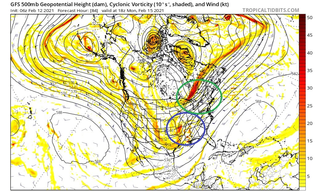
I'm sure I'm going to oversimply or partially misstate something here, but an area of high pressure in and of itself will not necessarily "block" a storm from cutting into it. Now if it's strong enough and has a solid depth of cold air with it that will offer some resistance and will help to funnel cold air down into the storm possibly extending the amount of time an area stays frozen. The other thing to look at is how blocked the flow is, if you have a ball of low pressure stuck under a block at the 50/50 Longitude / Latitude (What some refer to as a 50/50 Low) that also helps slow the flow down so a high will have more staying power.
The other than that really matters though is to look at 500, to block a storm from cutting you want confluence and you want the trough to not go negative to far to the West. So in the 500mb map below, the green circle you can see a piece of energy swinging by pushing the height lines in a more West to East (Compressing the flow between that and the ridge in the SE), that would imply once a storm gets to that point it's going to feel pressure to either move in a more Easterly direction or jump to the coast. The area circled in blue is the trough orientation, in this example its positive (height lines lean towards the right) This is indicative of a more progressive system still at that point and it would be less likely to cut and pump heights and subsequently flood us with warm air. As those lines become more straight up and down with a deepening storm, that's referred to neutral, and if they band to the left negative tilted trough. Also, pay attention to the colors, dark red would indicate there is a lot of energy in the trough, then do comparisons to previous runs to see if as we get closer in time there is more or less energy to discern a trend.
In a simplified way, just imagine those lines as like a roadway or path of least resistance, and that is the track a storm will want to take. Looking at this level of the atmosphere its really interesting and obvious how other down / upstream features will effect the track of a storm.
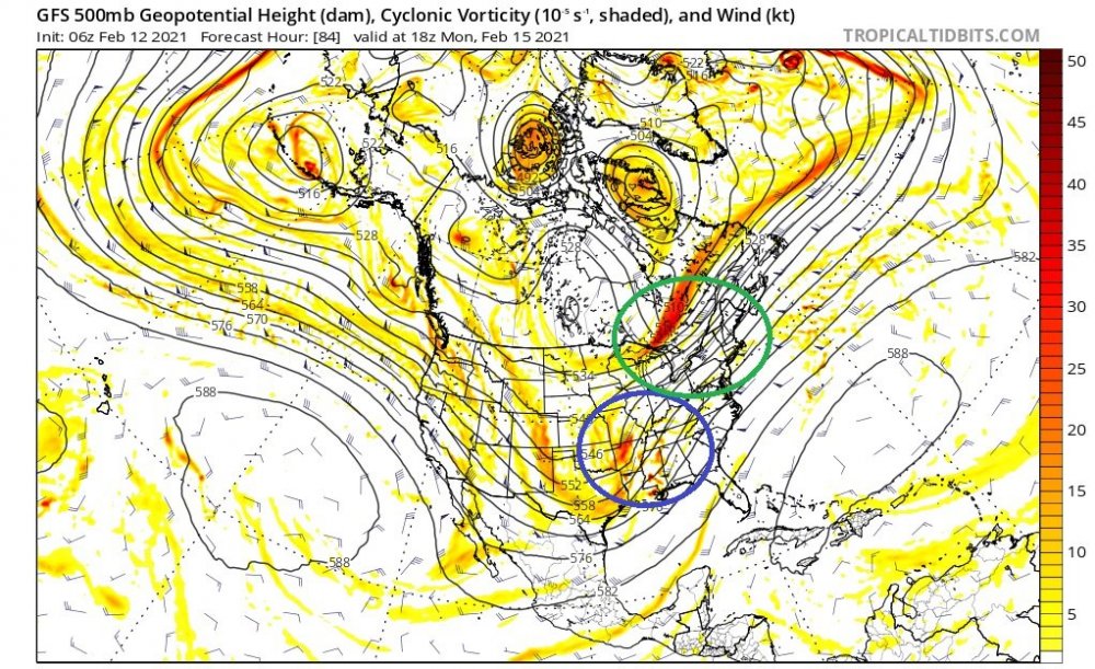
Yeah, many times we are rooting for it to go negative as it helps to capture and keep a coastal storm tight to the coast or on the Piedmont.
Rooting more progressive here at least until it gets past this point as depicted on the NAM. Taken literally, I think we would like hour 87.

-
1
-
-
-
GFS is looking a bit like the Euro. Runs a first wave out on Monday. We get a decent shot of snow out of it.
That’s great, but here is the question. Does that work to erode the high a bit, and thus let the bigger storm ride north farther?
Maybe, maybe not. It’s a good run for Western PA overall, just something to watch as to it being a tad warmer. It’s a mess farther east.
-
4 minutes ago, Rd9108 said:
Gfs looks pretty solid.
Looking Cleaner. HP doing it’s job
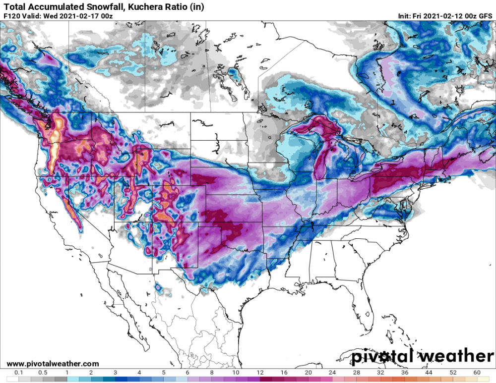
(honestly it’s probably not worth mentioning the 12”+ swath yet - but I guess I just did
 )
)
-
 1
1
-
 1
1
-
-
1 minute ago, Ahoff said:
Sorry, what's WTOD?
Warm. Tongue. Of. Death. :-)
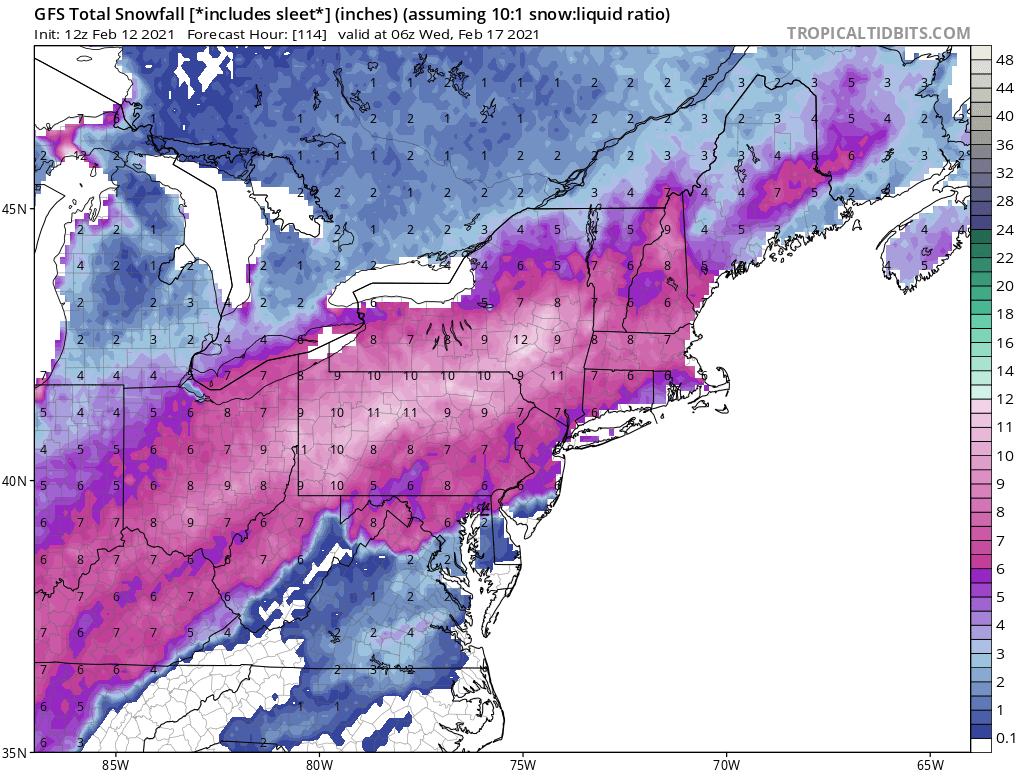
Euro looks to show 3 separate waves. An inch or so Saturday, a couple Monday, and then the bigger storm Monday night into Tuesday. The bigger storm tries to cut, but runs into a wall in Kentucky. Looks like it then redevelops in NC and runs up to the Delmarva.
Might not be completely clean, but certainly 8-10” through that period.
-
31 minutes ago, Ahoff said:
12z GFS leaves a bit to be desired on the Mon-Tues storm. It still looks like an improvement, but need a slight tick south still, but plenty of time.
It's showing temps in the teens, but freezing rain straddling the area. North of downtown is looking much better than south right now.
Also, it keeps the low in GA and the Carolinas, before exiting the Virginia coast, I find it hard to believe it would pump that much warmth into the 850 level from that far south. It's a nearly perfect track at this point, so we'll see.
yeah, It’s not the typical WTOD. We would keep our snow pack and still stack 7-8” on top.
-
28 minutes ago, MAG5035 said:
Starting to see the bigger flake size with the enhancement showing on radar.
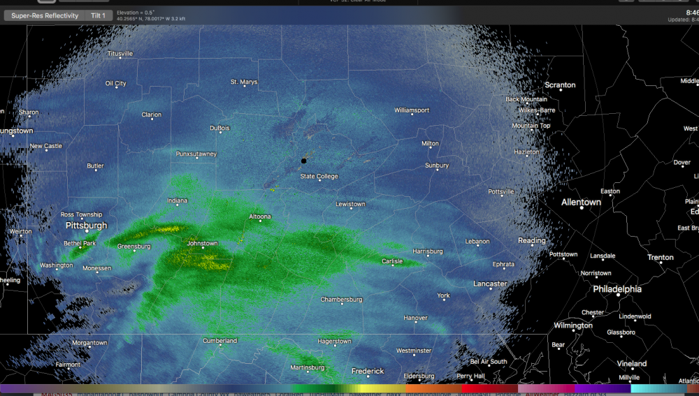
Got some nice fat flakes falling - 1.5”
-
We aren’t going to nearly have the moisture fetch that we had the other night. But again the frigid ground is making every flake count. Part of the reason roads became a mess quickly
-
1 hour ago, Mailman said:
GFS did come a little east.
Monday/Tuesday - Basically has 6-10” in six hours just north of the city. I mean a 80 mile wide 150 mile long swath of those rates. Obviously way too early to be looking at that
Still makes up west of us before a late redevelopment. So not great, but close to something big.
-
43 minutes ago, TimB84 said:
I would take an ice storm over 40 and rainy ten times out of ten.
I’d probably take it one out of ten
(but this might be the one since we would be preserving snowpack, and for once in my life I’m not commuting daily)
-
Canada loving Morgantown and the border counties tonight

-
1
-

Western Pa / Pittsburgh area Winter Discussion ❄️☃️
in Upstate New York/Pennsylvania
Posted
At least we know 200 mile NW jogs are possible in 24 hours for future reference (when needed)
This is nuts. Acodcotally you sometimes see a large late shift back SE to buck the trend but this just didn’t quit.
I’m curious to see how it plays out. Maybe we can get a nice front batch out of this, and more sleet to hold on to snowpack.