

Burghblizz
-
Posts
1,525 -
Joined
-
Last visited
Content Type
Profiles
Blogs
Forums
American Weather
Media Demo
Store
Gallery
Posts posted by Burghblizz
-
-
23 minutes ago, Bubbler86 said:
Sleet in Pittsburgh proper now.
It’s ripping here, despite what K-weenie sells. Been occasionally mixing, but heavy snow at the moment and still early on.
-
 1
1
-
-
As far as actual weather and not the weenie fest…
When you have a strong 925 jet advecting into cold air, you have the recipe for some intense rates. But might have to flirt with some sleet to get it.
-
 3
3
-
-
Heavy snow in Cranberry. 24 degrees. Wind driven smaller flakes have turned to big fatties
-
More wind driven and powdery than I was expecting to begin with
-
22 minutes ago, north pgh said:
I feel like I’m posting in the MA thread. I just took my dog for a walk and enjoyed the first dusting starting. If you sit here staring at the computer you will miss it. Enjoy.
One cat basically so weenied out that it makes it MA thread vibe. But they have like 20 like that
")
-
-
14 minutes ago, Mailman said:
It has begun to spit snow.
Keep those southern obs coming
-
1
-
-
15 minutes ago, north pgh said:
Hey let’s not forget as the snow is tapering to 1-3 inches by lunch time tomorrow wind are going to gust to 30 mph. Lots of blowing and drifting.
If we can avoid the snow cone, the blowing and drifting might be understated to this point
-
4 minutes ago, RitualOfTheTrout said:
Yeah, some of the heaviest snow looks to fall before 1am, then go to bed and don't fret the slot and wake up a few hours later and watch radar fill in, that might be my plan lol. Being east of the city my yard probably needs more of an adjustment.
That’s my plan too. Sleep during dry slot :-)
-
1
-
-
Just now, TimB84 said:
Thing is, the models suggest we could already have warning-level snow on the ground when Ben lines up in the victory formation and takes a knee.
That’s the plan!
(but I plan on a fun night regardless)
-
1
-
-
Yinz are going to drive yourselves nuts clicking on hourly increments of hourly models for the 8 hours, and checking where the pretty colors line up.
I think E to W across central AGC will be the difference between 8 and 12 because of dry slot duration. And N to S along that axis will add or subtract ~2” from that range.
Beaver /Lawrence/Butler certainly have a shot to pop a 15” total.
-
1
-
-
3 minutes ago, Ecanem said:
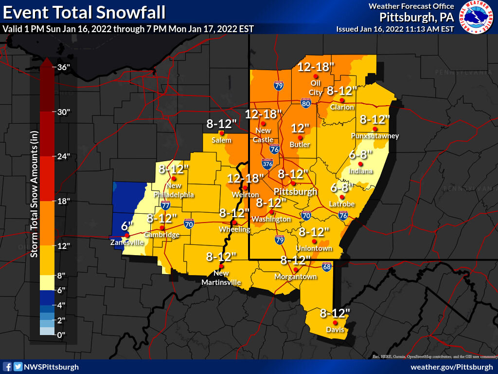
Fwiw here is the official call from nws at 2 am

And just for fun the “best case” experimental view. That dry slot on NAM is still pretty fierce where I could see a place like Wheeling doubling up Greensburg. But in general, the NAM seems to have lost the total shit show solution, which is one of things I wanted to see.
-
3
-
-
Not sure how Tolleris is resolving the fact that the NW edge outside his sleet line is where the totals should ramp up - yet that’s where he has the totals drop off. Probably the single most important issue in terms of where big totals wind up.
He tries to forecast for a wide area, and doesn’t put diligence into those areas.
-
1
-
-
I’ll start to worry about the NAM at 0z.
At that point, all the anecoctal, weather fan reasons to toss it become fewer. It will be an on hour run with the storm arriving within 24 hours. That’s usually where it’s considered good.
-
1
-
-
5 minutes ago, Ahoff said:
Yes!
This feels a bit different than 2019, not totally sure why, but it does. Doesn't mean we don't mixing, but doesn't seem as harsh as that.
Way different with low track. And mixing here means potential sig ice, not rain like in 1.19
-
If we can avoid the frozen snow cone…and I think most will to a large degree…they really might want to consider adding “bowing and drifting” to the forecast Monday. Could be 30 MPH winds with snow showers and a lot of snow on the ground.
-
1 minute ago, meatwad said:
I wouldn’t worry about the exact orientation of pink and blue. I think that’s a 2” hour.
-
1
-
-
11 minutes ago, MikeB_01 said:
I just think this is where met intuition / experience comes in ahead of modeling. The discussions are full of comments about the rate of evaporative cooling. Even if we sleet, it should be brief and then we should be thumping again.
I think this is why we all do well - but it’s like 5” to 12” well, as opposed to a nice tight range.
Where it’s ripping it will be ripping. Where it’s not, it might be a light mix for while, which will further hold totals down. So any prolonged period with that gets you behind the game.
So a deeper storm hurts - because of the warm air aloft. But it also can HELP with dynamic cooling.
-
When the bad outlier for PIT is 7”, I’ll take it. It does really show the worst case scenario though for Fayette and Westmoreland
(talking NAM)
-
23 minutes ago, TimB84 said:
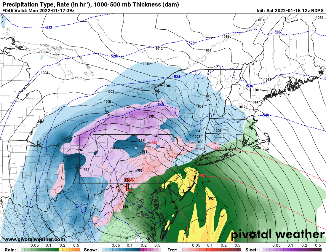
Not sure the RAP is worth anything, but the 9z run had 22” at PIT.
It’s good if you want to see if a you have some good rates in the next few hours - but I wouldn’t look at totals 30 hours before the storm.
-
GFS looking nice and robust still at 18Z
-
10 minutes ago, MAG5035 said:
I do feel the same way, but I don’t completely discount the NAM’s robust warming higher up near the 850mb level either. But same stuff as 12z. The money 3hr frames for ZR are 60 and 63. Using my nearest station at KAOO as an example since I’m in the thick of the heavy ZR over here.
HR 60: Surface -6ºC, 925mb (~3k ft) -6ºC, 850mb +2ºC
HR 63: Surface -2ºC, 925mb -3ºC. 850mb back to 0ºC
Even with that basic breakdown at the major layers I look at that and ask what part of that suggests that particular station sees 0.78” as freezing rain? I think something toward a NAM scenario might get a few hours of sleet into the central and *maybe* western counties. But Pitt’s advantage is the 850 low tracks favorably on the NAM for western (and serviceable to central counties) plus overall flow is on the cold conveyor belt side of the low. We don’t have an Ohio Valley low with SW flow intruding in this situation and trying to overcome that with a secondary to the coast. The warm advection comes from the tremendous easterly flow aloft with the coastal low. I can’t really think of a situation in the past that has presented the NAM type scenario of that much mix/ZR into western PA so that would be a new one to me if it happened.
Thanks for your thoughts. He was weenying out a bit
-
 1
1
-
-
13 minutes ago, KPITSnow said:
The 18z NAM is a clown show lol
If you are looking for a trend, it’s snowier than 12Z. Fills in a wider swath of 6”+ and gets that 12+ tail closer from the NW.
Sure, Its the worst model for us still, but it’s better than it was.
-
3
-
-
GFS looks fine. 12-15” city and points North and West. More mixing south and east, but still warning snows there too before any crap. That 119 corridor looks most susceptible.
Seems to extend the backend a little too. A post storm snow globe day Monday would hit the spot.

Western PA/Pittsburgh Winter 2021/22 Discussion
in Upstate New York/Pennsylvania
Posted
Dumping - back to all snow in Cranberry.
2.5” and .5” fresh during the 20 min I was just walking the dog