

Burghblizz
-
Posts
1,525 -
Joined
-
Last visited
Content Type
Profiles
Blogs
Forums
American Weather
Media Demo
Store
Gallery
Posts posted by Burghblizz
-
-
2 minutes ago, north pgh said:
Today has been a nice surprise of a day. Snow has been falling and blowing the last 6 hours with winds of 25 mph. These days always amazed me because it is 22 and snowing here and 50 across the state in Philly. That's why I will take our Winter climo over theirs any day.
These days are nice when u have a decent snowpack.
-
Just now, TimB84 said:
Likewise. I didn’t live here in 2010, unfortunately. I was old enough in March 1993 to know it was historic, but 8 year old me certainly wasn’t tracking the storm. So I have yet to track even a 12” snow event in Pittsburgh, unless I’m forgetting one.
60 days ago...:-)
-
 1
1
-
-
NAM a little better. Looks like 7-8”. Double digits into Greene and Fayette. Nice little 12-15” weenie area in northern WV.
Just need to pop that north a bit (I’m talking that precip area, knowing that it will be shaved down in real life)
-
2 minutes ago, MikeB_01 said:
Agree with this. I wasnt here for the historic 2010 storm. I was in Youngstown still. While we picked up about a foot, you guys know how good it feels to be so close to something epic. Even picking up a foot stung in that situation.
That was me in Dec ‘92 and Jan 96. But I’ve learned that I’ll deal with that if I get a foot. That’s kind of my threshold
Now 1.16 was a kick in the nuts. Got 5” while 40 miles away got 20”
Thankful to have been on the good side of that in 03 and 2010
-
1
-
-
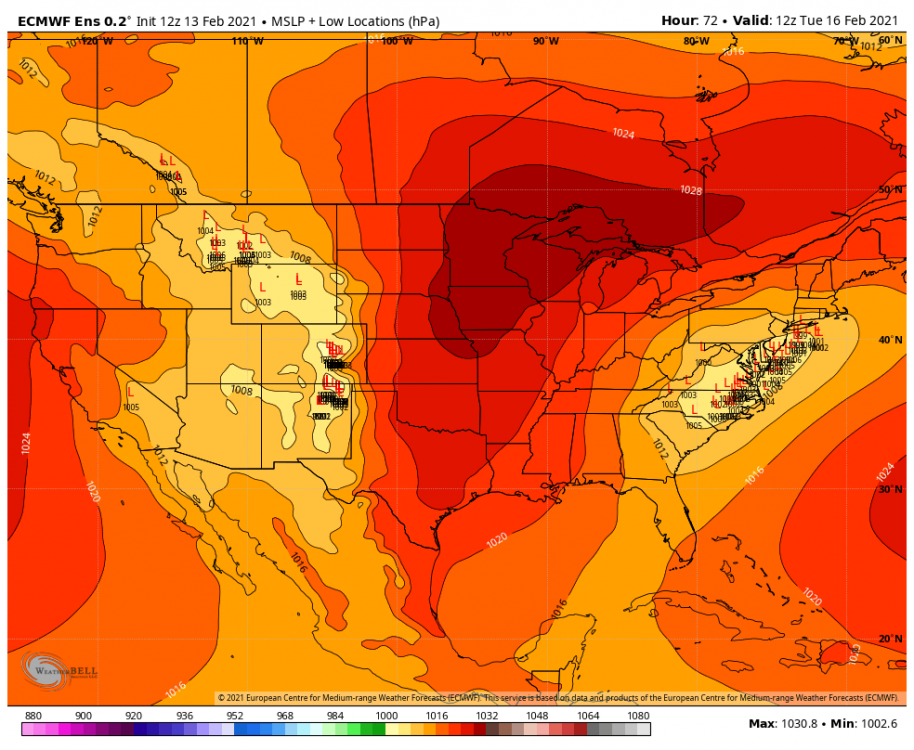
Here were the Euro ensembles on Saturday. Not 5 days out, 48 hours out. As tight of a cluster as you see, with one major outlier. It wound up west of that outlier.
Not sure what caused performance that poor, but certainly some time for this to slide NW this time.
(Again, from Saturday)
-
1
-
-
36 minutes ago, Rd9108 said:
This has overperformer written all over it. No science behind my prediction but I'm just feeling like 7 or 8. As always dont listen to me though I'm just a dumbass weenie.
The “science” is the southeast bias in the models. Let’s watch them come to us over the next 24 hours
(Of course when we need it...lol)
-
5 minutes ago, Rd9108 said:
Looks like they used to do it.

That used to be taken from NWS. They started doing their own like 15 years ago
-
1
-
-
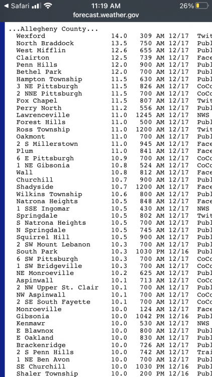
I’m not sure places north and west did that great, even into western Ohio and New York State. Seems like a lot of low ratios and quick moving. I didn’t really look until now, but wanted to see what we missed out on.
-
3 minutes ago, north pgh said:
They should all be scared. It is too early to post accumulation amounts. They should use the old forecast from years ago and say ...snow with some accumulation possible. Wait until tomorrow when these models are more in line.
Right - I like the old “significant accumulation possible” as an alert. But I’d wait for actual totals.
Or you pop up a couple scenarios.
-
1
-
-
41 minutes ago, dj3 said:
I'm surprised the NWS is bullish on this one. It looks like a relatively weak low and it doesn't really strengthen much as it turns up the coast despite taking a pretty good track for us.
Lot of moisture streaming up though, and better HP placement. I don’t think this has the 10” potential the last one did, it I’d rather shovel 5” of snow than 10” of potential
-
2
-
-
Skating rink right now, with a lot of precip to go. At least it’s pretty fast moving.
We haven’t had a true ice storm in awhile - usually pretty transient on the way to rain. But this looks like it could get rough.
I used to like them as a kid because they “felt” like a snowstorm. You got your NWS headlines and off school.
-
Just now, CoraopolisWx said:
Love the rare daytime heavy snow.
Keep on padding the stats.It’s Amazing our propensity for night snows
-
1
-
-
2 minutes ago, Rd9108 said:
Looks like the NAM has the snow/sleet line wrong. Stolen from LakeEffectKing in the Upstate thread.

Lol - don’t start. I already found myself noticing HRRR soundings holding on to snow a little longer.
Maybe we can squeeze out a quick second thump before the ice
-
Thumpin hard right now. I went outside. Need to enjoy every flake for the time spent - lol
-
1
-
-
Icy as hell out again. Not sure if there was more freezing drizzle overnight, or this first batch of snow started as some
-
2 minutes ago, SteelCity87 said:
Just want to point out that in the 13 years I've been on weather forums that this is by far the most active our sub forum has been

It’s been a fun year overall, despite this recent mess. Still think this winter has something more in store
-
1
-
-
7 minutes ago, RitualOfTheTrout said:
In theory a stronger more NW storm could serve to suppress heights in the east and boost confluence allowing the Thursday storm to track under us.
It does show some blocking and a decent (6”+) hit of snow. Also shows it retrograding through Ohio, and then creating a mess. I’m going to really try not to model watch again until Wednesday
-
At least we know 200 mile NW jogs are possible in 24 hours for future reference (when needed)

This is nuts. Acodcotally you sometimes see a large late shift back SE to buck the trend but this just didn’t quit.
I’m curious to see how it plays out. Maybe we can get a nice front batch out of this, and more sleet to hold on to snowpack.
-
Germans keeping it mostly clean in AGC
(although I guess they don’t believe in other P types)
.gif.4268bfad15a0dfc843074a8862f8f3cd.gif)
-
1
-
-
1 hour ago, canderson said:
My parents’ grid forecast in northeast Texas is NUTS. Please pray for Texas. They can’t handle these temps ask the infrastructure and houses can’t handle it either, or the snow/ice.
TonightA chance of snow and sleet, mainly after 4am. Mostly cloudy, with a low around 19. Wind chill values between 9 and 14. North wind 10 to 15 mph, with gusts as high as 20 mph. Chance of precipitation is 40%. Total nighttime snow and sleet accumulation of less than a half inch possible.SundayA chance of snow and sleet before 10am, then snow likely. Cloudy and cold, with a high near 23. Wind chill values between 5 and 10. North wind around 15 mph, with gusts as high as 20 mph. Chance of precipitation is 60%. New snow and sleet accumulation of less than one inch possible.Sunday NightSnow. Areas of blowing snow after midnight. Low around 6. Wind chill values between -1 and -11. North wind around 15 mph, with gusts as high as 25 mph. Chance of precipitation is 90%. New snow accumulation of 3 to 5 inches possible.Washington's BirthdayA 20 percent chance of snow before noon. Mostly cloudy and cold, with a high near 15. Wind chill values between -2 and -12. North northwest wind around 15 mph, with gusts as high as 25 mph.Monday NightMostly cloudy, with a low around 0. North northwest wind 5 to 15 mph, with gusts as high as 20 mph.TuesdayPartly sunny and cold, with a high near 23. North northwest wind 5 to 10 mph becoming southeast in the afternoon.Tuesday NightA 40 percent chance of snow, mainly after midnight. Cloudy, with a low around 18. East wind 5 to 10 mph.WednesdaySnow, possibly mixed with sleet. High near 28. East wind 10 to 15 mph, with gusts as high as 20 mph. Chance of precipitation is 80%.Wednesday NightA 40 percent chance of snow. Cloudy, with a low around 21. North wind 10 to 15 mph.ThursdayA 20 percent chance of snow before noon. Partly sunny and cold, with a high near 30.Thursday NightPartly cloudy, with a low around 12.Were they there in 2010? Think that’s when Dallas scored a foot. That likely will never be matched there.
-
3 minutes ago, Ahoff said:
So, just to be clear, you're thinking it's just a one off run?
Just saying it’s a mesoscale model that is usually over amped with a west bias outside of 36 hours. If the globals all trend that way tonight, then I’ll be more worried
-
You know how sometimes the NAM reels us in when we are on the western fringe? This is that run for Illinois. I doubt other guidance follows.
And when it’s right or “on to something” outside 36 hours, it’s usually with rapidly deepening systems
-
1
-
-
2 hours ago, Mailman said:
18z HRRR looks good after wave 1.

I was about to post the same “probably too early” look at it as well. It’s showing that first wave to be pretty robust.
5” by noon Monday would be off and running
-
1
-
-
I’m less concerned about total output at this point and more concerned with sliding that boundary to the SE. Keep some wiggle room
-
2
-
Western Pa / Pittsburgh area Winter Discussion ❄️☃️
in Upstate New York/Pennsylvania
Posted
Those Southern Ohio zones (which would figure to do similar to us with this) have a lower threshold. They can pop em up with 4”+ expected