-
Posts
1,525 -
Joined
-
Last visited
Content Type
Profiles
Blogs
Forums
American Weather
Media Demo
Store
Gallery
Posts posted by Burghblizz
-
-
Those 35/40 DBZs have arrived and it’s ALL Snow
-
7 minutes ago, jwilson said:
I'm seeing some 35-40 DBZ returns to our south in Greene county. Is that sleet or an intense band of snow?
Mailman probably a good person to stand guard for that
-
1 minute ago, north pgh said:
Yes. It has been a couple years since we’ve had a daytime snowfall. It’s much more fun watching the snow fall then just waking up and having it on the ground. And we will also have steady snow moderate at times for the next 12 hours.
Agree - I think that 11” in March a couple years ago was mostly daytime, or at least kept going into the next day. But most of the more significant snows the last 10 years seem to be mostly at night.
-
 1
1
-
-
Ripping out here already. Hopefully means more expansive and not just “early”
-
With coastal development in the Carolinas as opposed to further north, I don’t think the tongue makes it accross the M/D line. So I say let’s flirt with It and bring in more WAA snows
-
 3
3
-
-
Reminder: snow is awesome. Time to get out of the models and outside!
-
 3
3
-
-
NAM is interesting because it closes off, and then has SLP retrograde a bit. Not sure that has been depicted yet.
It’s probably a little too late for that to have a meaningful impact as it had already begun to slide east and offshore. If it would have done that at the Chesapeake, then it could really mean something.
Still all a computers imagination, so we’ll see what happens!
-
Yeah Euro is fine. I don’t think this ever was going to be a 15”+ storm here.
The last 4 storms that cracked 15” (93/94/03/10) all had huge closed lows. It’s too progressive.
Overall good trends in the last 36 hours overall to get it to something significant. So need to keep that perspective. Still think 6-8” is a good bet. Maybe touching 10” in eastern areas.
-
2 minutes ago, Rd9108 said:
Euro still looks good.
Smokes Westmoreland

-
4 minutes ago, KPITSnow said:
Adjusting my call. 2-4 as the last minute model shift to the East happens.
Easy man...it only shaved a couple inches off and these off hour runs can be lighter. Tracks looked almost identical. Let’s see how things are after tonight. That’s the final model exam.
-
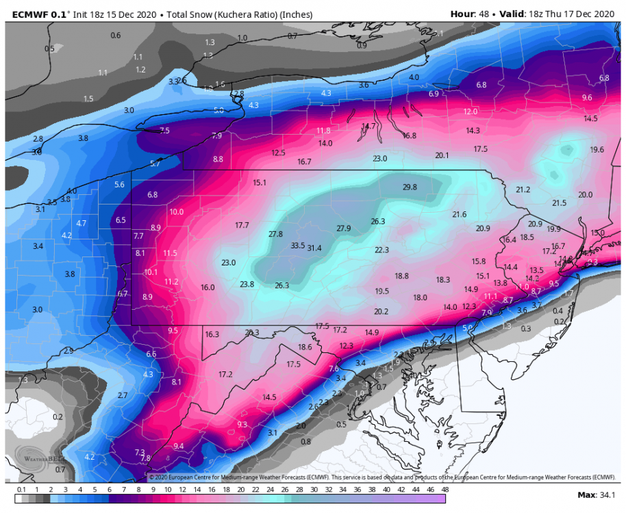
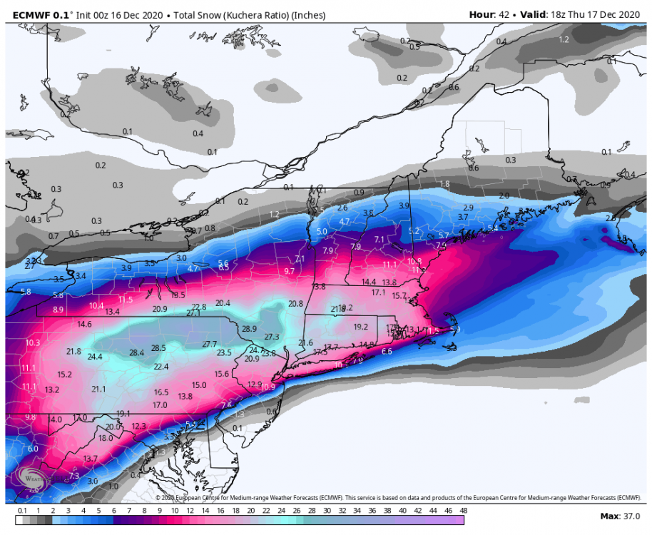
If I had to give a public forecast, I’d probably say 6-10” west to east across AGC.
The only thing concerning me about challenging some of those higher model totals is the progressive nature of this. Relatively quick window to capitalize
-
2 minutes ago, Rd9108 said:
This looks more realistic. Highly doubt we get over a foot
Has 12” close to Allegheny/Westmoreland boarder. I’ll take it since that’s almost my backyard! That’s likely to dance around with a rapid refresh model.
-
22 minutes ago, north pgh said:
We went from being fringed with 2-4 to a possible foot with some mixing issues and people are complaining?
Even if I get 6-10 and have to mix for an hour or two I will take it.
BTW I think that the mixing will be minimal if any.
I tend to agree. This isn’t like a WTOD where it overwhelms with a strong inland storm. It should flip back even if there is a period of slop.
-
12 minutes ago, jwilson said:
Wow, the 12Z NAM doesn't back off. That's incredible. The last time I remember the NAM scoring a coup was 2016, when it was north of all of globals, then with 24-36 hours left, all the globals came north to the NAM. I'm not buying just yet, but I've got my wallet out.
Even with the Ferrier correction on the 3K, Pittsburgh metro gets a foot. It shifts the jackpot from Harrisburg to Lock Haven, which isn't insignificant (about 70 miles). If PIT gets under the CCB as it forms along the axis, it could happen, but that's relying on a very specific feature.
That banding can be iffy, but definitely can lead to overperforming storms. That 11” we got in March a couple years ago had that.
-
 2
2
-
-
-
While you were sleeping, my hard work has produced:
-Winter Storm Watches expanded to southwest PA counties
-Euro looking more robust at 0Z
-NAM going nuts at 6z. Wont even mention those totals
-GFS at 6z coming around, creeping 8-12” totals in south and east of the city. Would love to see one more push with that.
If we can have SLP track to the Chesapeake and have this close off at 500, it’s legit game on. That would turn WAA snows early on to the more prolonged/heavy CCB.
-
 3
3
-
-
5 minutes ago, meatwad said:
Didn’t the 1992 December storm do the same thing?
That was a bigger, more explosive storm. It was much warmer to the east. But the setup is pretty similar.
That had a first wave that overperformed as there was supposed to be heavier snow later with the coastal. But the epic snows later really only made to Somerset (3’). Still a foot of snow and a memorable storm
-
1 minute ago, KPITSnow said:
I'm no expert but it looks like the NAM is coming in North and West. The high in Canada is pretty significantly north of 18z.
My weenie eyes saw the same thing
-
It would be nice to verify on higher end of those plumes again. Will be tough to do that back to back
-
1 hour ago, Rd9108 said:
Looks like the NAM closes off the low and is tucked.
Likely the NAM being the NAM. The 6z GFS did tick a slight bit west but looks nothing like the NAM. Maybe the NAM steals a victory but no other guidance looks like this. Still time for things to change and we've seen now casting where a low ends up 50 miles west or east of the major models.
Noticed that as well. Will be interesting if that keeps showing up. NAM might be overly optimistic, but it seems the upper levels as it depicts it supports its track
-
NAM sometimes a trend, sometimes a tease. And 84 hours is only wed eve. Hope the globals can provide a similar look by tonight.
-
4 hours ago, CoraopolisWx said:
Seems like the OP’s have the 850’s more tightly wound.
Would like to see a more elongated 850 low, and 500 low for that matter.
Basically if someone else has to get 2ft for us to get a 1ft, then so be it.Agree - as long as it’s a solid foot and not 10 miles away :-)
1.2016 was the worst in recent memory. 5” and 15 miles from me had 15”. But you clear a foot all is good
-
 1
1
-
-
29 minutes ago, Jns2183 said:
I don't believe Middletown or any of the previous location of the weather station have ever recorded a day with more than 10" of snow in December. As depicted this event is almost on the scale of what tropical storm Lee did to the swatera creek in 2011
Sent from my LM-X210APM using Tapatalk
I feel like Christmas ‘02 would have been as I was there (Unless you mean physical calendar day which I’m not sure)
-
1 hour ago, RitualOfTheTrout said:
Heh, man what a track.. Nothing like these old forecasts with big CRT monitors etc in the background.
I remember that TWC map. We had a first wave that overperformed and were sitting on like 8 or 9”. That supposed to be 12+ additional, but the big snows from the coastal cut off around somerset. We wound up with about a foot total where I was. Pretty sure they got 3’ in Somerset


Western Pa / Pittsburgh area Winter Discussion ❄️☃️
in Upstate New York/Pennsylvania
Posted
This band was thumping! Hardest synoptic snow I’ve seen in awhile