

Burghblizz
-
Posts
1,525 -
Joined
-
Last visited
Content Type
Profiles
Blogs
Forums
American Weather
Media Demo
Store
Gallery
Posts posted by Burghblizz
-
-
5 minutes ago, SteelCity87 said:
Why I do not remember 2013-2014 being that snowy? Lol
It was all nickel and dimes. I think there might have been a couple 5” type storms.
-
 1
1
-
-
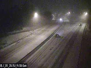
Parkway East taking a beating already
-
1 minute ago, MAG5035 said:
Should be seeing snow start here within the next hour or two by looks of the radar. Hoping that this precip swath finds it's way a tad south of where the 0z short range guidance like the NAM takes it. Could be a fluff bomb for whoever gets the best rates.
Nice start out here. Ramped up fairly quickly
-
Definitely every flake sticking so far. Could be an efficient little storm
-
I can see how this week is shaping up...
Looking like some nice little snow events this week. But we may not enjoy them since we will be obsessed chasing what the GFS is advertising Sunday.
Reminder - enjoy the snow that’s falling since the 6 day GFS is likely going to change :-)
-
3
-
-
11 hours ago, TimB84 said:
I’m as much a fan of cold as I am as a fan of snow, which is to say a pretty big fan. These seemingly endless streaks of above normal months that have become so common, especially in the past five years, are exhausting.
Your bar for cold is pretty high. 12 degrees out right now, and hasn’t hit 40 this month. Hasn’t hit 50 since just after Christmas. Some bitter cold still chances in the pipeline
Not sure if “84” is your birth year...but if it is...trust me it will start to feel colder the next 10 years

-
Looks like a good shot at two separate 2-4” snows this week. Latest GFS also shows a bigger storm for Valentines Day. Verbatim it cuts a deepening storm towards a 1036 high up the Ohio River. Would be a big hit for central Ohio, with a rain to snow here. But plenty of time there.
-
1
-
-
Just now, Rd9108 said:
The NAM is tricking these people into thinking they are getting a 8-12 if not more storm. I'll take any snow at this point and wait for 93 redux.
It’s likely too progressive for anything big
-
GFS bringing 2”- 4” into the Mon Valley Sunday. So not quite dead yet for at least some accum
-
I admit I was kind of excited in ‘94 to get to -22. Felt like I was seeing history and so I definitely rooted for it. But I can probably take or leave extreme cold at this point.
-
12 minutes ago, TimB84 said:
Someone can probably verify this but I’m going to say anecdotally we haven’t been below -10 since that infamous day in 1994.
2009 and 2015 saw double digits below zero officially.
-
A significant shift is doable because we are talking about phase/no phase and the timing. So I wouldnt be suprised if it jumps one way or another in the next 24 hours of models
-
10 hours ago, CoraopolisWx said:
A couple lake enhanced snow bands is not out of the question today and tonight. So my 8.7” call still has a chance to verify. Lol
Final official total was 8.5”. Felt like less in most places due to long duration and compacting - but NWS does a good job counting every inch properly. Credit on their forecast too. This was a pain, but 6-8” over 48 hours was a good call.
(if we catch a band later, not sure we can count it
 )
)
-
1 hour ago, MAG5035 said:
The initial WAA phase of the storm with the primary is where I came up pretty short as better precip kind of split this area (going southern tier and up around UNV and N from there). I had under 2 inches all the way until later Sunday Evening. A few more inches from that and would've pretty much been on target with what I expected here. Otherwise, the 8-14" call with the imbedded area of heavier amounts ended up working out pretty good.
We wound up with around 7”. Same main issue getting the intial batch going.
-
1 minute ago, Ahoff said:
And no real snow to boot. I'd trade the bitter cold if it meant more snow, but now we have less snow and less cold, lol.
Still sends SLP up the Piedmont to the Delmarva. It closes off too late (compared to yesterday) and doesn’t have an expansive shield. But the players are there.
-
There is a much more consolidated batch entering eastern Allegheny county. Not sure everything behind it holds together, but looks like the best shot at some more steady snow.
Also, nice vertical lake enhanced band in central Ohio. Never seen WWA in vertically stacked counties like that - lol. Not the greatest storm for us, but still doing some interesting things.
-
1
-
-
5 minutes ago, Rd9108 said:
Is this why we don't trust Miller bs for our area?

I mean “technically” 2.2003 and 2.2010 were Miller B’s. But they also had a huge primary storm with a great track prior to hitting blocking. We also had a nice one in 12.2003, and probably a few others.
But I really don’t like the textbook exploding Miller Bs for our area.
-
27 minutes ago, CoraopolisWx said:
Curious to see how far west the heavier bands make it today.
Canadien had them in our area yesterday.Same - looks like some are making some progress. Overall will crack 40” today with more opportunities in the pipeline
-
1
-
-
A Hard fought 3.3” so far officially as of 7:00
-
4
-
-
1 minute ago, Rd9108 said:
Yep ill take that. I love moderate/heavy snow. That's why in my opinion ill take a 1994 storm over 2010 any day. Of course I'd love to see a 1993 storm since I was 2 when that hit but that's a once in a lifetime storm.
2010 didn’t quite have the extreme ‘93 and 94 rates (3-4” hour), but it have some have prolonged really good rates. I remember getting like 8” in 5 hours from 7 to midnight. And then there was another period from like 3 to 6 AM where we tacked on another 5”
-
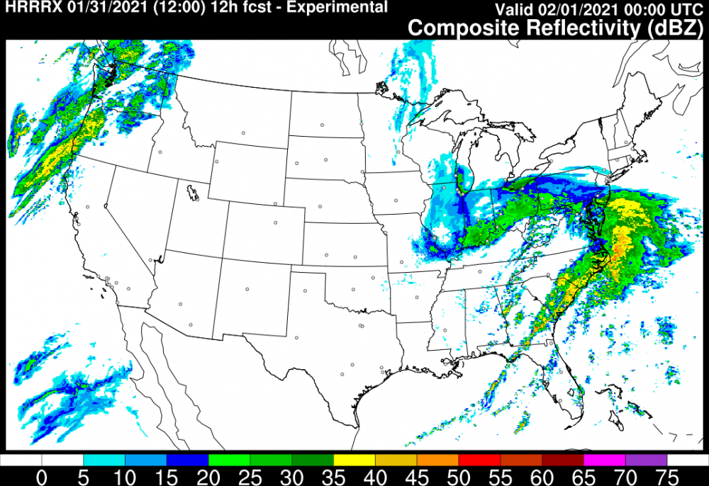
I like this look from the HRRR for this evening
-
3
-
-
18 minutes ago, KPITSnow said:
Hey I want to be clear...everything after December is gravy. I’m not complaining, just pointing out concerns in the evolution of the system.
All good! I know you weren’t really tracking this one the whole time, but this is the way it’s been really the last few days. It’s always been kind of a long duration, moderate event, with this outside shot of scoring big.
-
1
-
-
3 minutes ago, KPITSnow said:
It wasn't over 36 hours.
It was more like 24 hrs - but it also had some nice bursts. Hoping the same here
-
Just now, Atomixwx said:
What's that supposed to mean?
Kpitsnow and his complaints.


Western Pa / Pittsburgh area Winter Discussion ❄️☃️
in Upstate New York/Pennsylvania
Posted
Reminds me a little of just a fat Lake Effect band training. Seems to be some 4” and 5” totals already south/south west of Columbus (while CMH itself is looking a bit shafted)
I think some from that area to here sees 6” if we can keep the goods training.