

Burghblizz
-
Posts
1,432 -
Joined
-
Last visited
Content Type
Profiles
Blogs
Forums
American Weather
Media Demo
Store
Gallery
Posts posted by Burghblizz
-
-
Nice fresh 3” today
-
 1
1
-
-
24 minutes ago, meatwad said:
The radar is building again.
Nice steady snow off this batch. Some nice bourbon in hand.
-
1
-
-
10 minutes ago, Rd9108 said:
I'll take the possibility of getting a blizzard of 93 or 2010 over scoring on the 6-12 storms more often.
If your in Columbus or Indy, it’s pretty lean on both
-
1 hour ago, TheClimateChanger said:
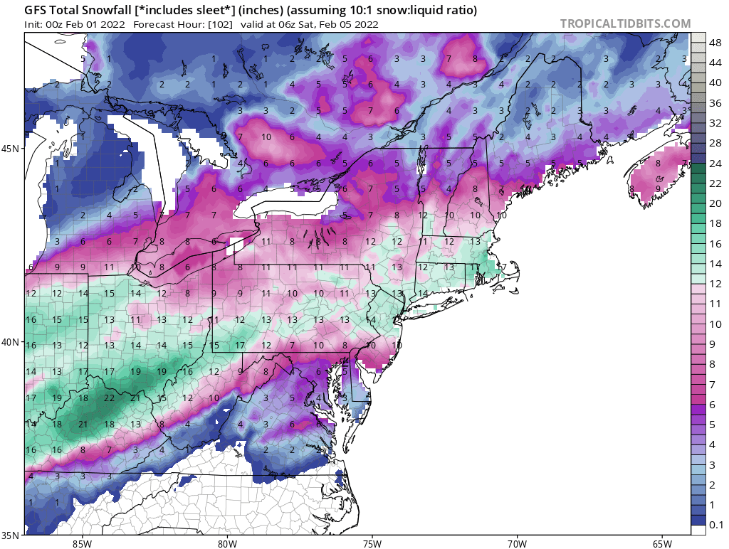
Some of the models were suggesting YNG airport could get 16", and I checked and there has not been a two day storm total that higher there since November 1950. And compared to Columbus and Indy at a similar latitude, PIT has had way more big storms.
Yeah, it’s not even close with Columbus and Indy. C-bus has been hurting as I don’t think they cracked 6” in like 7 years. We are in the game far more often, so take a lot more L’s. But the net result is more big storms than all of them. Like I mentioned before, YNG was on the NW fringe of most of our really big storms, even though they tend to swipe some of our mid sized ones.
-
2 hours ago, TheClimateChanger said:
Just for context… Toledo’s 12.5” storm total was sixth biggest on record.
https://twitter.com/jayberschback/status/1489460096140775428?s=21
Interesting that they went almost 100 years with only 2 12” storms. Then have had 4 in 11 years.
-
1 minute ago, Rd9108 said:
nice surprise after a break day yesterday. enjoy everybody the rare daytime snow
Yeah, love it. We are normally nighttime snow magnets
-
Some nice bands blowing up again in AGC. Almost like LES but coming from the SW.
-
1
-
-
Yesterday was like watching paint dry. Wound up with ~.30 ice accretion with the snow line agonizingly close for hours in the evening.
I’m catching some of that Northern Allegheny band now. Nice fat flakes.
-
2 minutes ago, TheClimateChanger said:
HRRR is getting up into crazy territory in northeast Ohio. When was the last time Canton and Youngstown had 16 inches or more? March '93 Superstorm?
I have to think they have had some since then (seems as though they have cashed in on a lot of our snow over the years)
But fair thought - our storms since that got close or over that (‘94, ‘96, ‘03, ‘10) were considerably lighter there.
-
Hoping to see reports of cold racing east
-
Euro looks good NW of the city. Gives me about 8”
(also about 20 miles from 4” and 20 miles from a foot
 )
)
-
1 minute ago, PghPirates27 said:
lol my point and click has no accumulation.... 6 miles away point and click shows 5-8". Crazy gradient.
They should manually smooth that out. Doubt it plays out that way
-
4 minutes ago, donyewest said:
When we first moved to PA in Nov 2018, just started to unpack and lost power because of the ice storm for 12 hours. I thought the power infra would be more resistant to winter weather because the area deals with it all the time, haha, I was wrong.
There definitely is a good chunk of the area that has a combination of trees and above ground lines - not a great combo. But severe ice storms aren’t too frequent thankfully.
-
NAM slightly colder and also develops another wave.
Taken literally, the city is in icy hell in between, but dropped the bigger totals a little closer from the north, and then developed another band of 3-4” snows south
-
4 hours ago, RitualOfTheTrout said:
Draw a line from City of Pittsburgh to Clarion, the further North / West you go will be rapidly increasing impacts. South and East of that line rapidly decreasing impacts. That's my take based on looking at all the 6z data / 12z NAM. Still almost 36 hours until we get into the part of the storm we are all interested in, so any minor adjustments one way or the other will have big influence on sensible weather. Slower / Less amped look of that wave is what we want, but the trends have been slightly in the opposite direction on the GFS / NAM so lots of stuff to track / analyze.
The front really slows down as I mentioned before, and there is some warm nose influence as the freezing line even bumps NW a little bit. Looks like the counties NWS has highlighted in the watch currently is a good call although I could see an expansion eastward with advisories. Most counties currently in the watch would hit warning criteria based on freezing rain.
I think there will be last minute shifts that will drive us nut - But this is the accurate story to me as well.
Since I’m a bit NW of that line, hoping for more snow. Certainly support for 6”+ N of the city - just TBD if that starts at 5 miles or 50 miles.
We’d be in better shape if we get a little more eastern progression before the main wave comes and tries to advect warm air.
-
16 minutes ago, Ahoff said:
It is?
I wouldn’t feel great in the WV border counties, but rest of the area still has a shot. Obviously even better North and West of the city.
-
1
-
-
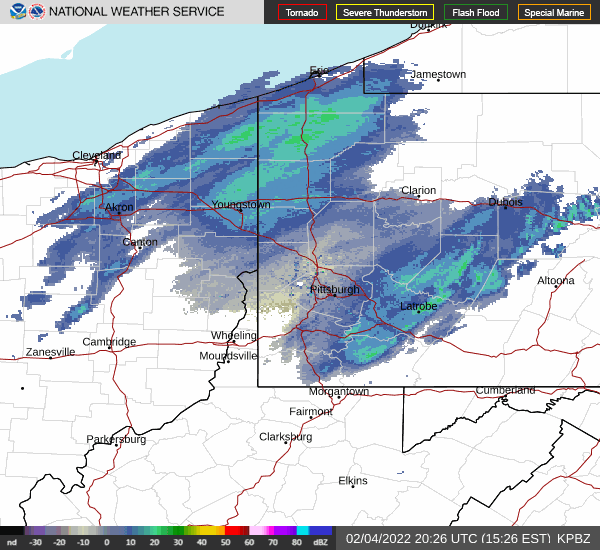
26 minutes ago, TheClimateChanger said:
Our south ticks are killing the storm. Now looks like a rather pedestrian snow event (7-10 inches) for most of northern Ohio and western New York. Maybe a few lollipops up to a foot in the favored areas with a bit of lake/orographic enhancement.
Those areas aren’t staying in the waves of precip as long due to the slightly more progressive nature. So it was more timing as opposed to system strength.
GFS has a chance to be the king here. I feel like others are trending to it more than it’s trending to others. But you still have to be concerned about a tick the wrong way.
-
I weenied out a bit and looked at the soundings for my backyard (Cranberry). It was right on pivotals sleet line, but the soundings never went above freezing at any level. I’d love to see another model join the GFS though. Getting real close to something nice for northern AGC and points N.
-
1 minute ago, tim123 said:
I bet his in house model counts sleet
Maybe - but I would think they would manually adjust that for a public forecast
-
1 minute ago, TheClimateChanger said:
I saw this in the Ohio thread from a TV meteorologist in Cleveland. Brings a foot and a half of snow all the way to the Ohio River in eastern Ohio... what model is showing that? I thought this might raise spirits here though. Lol.
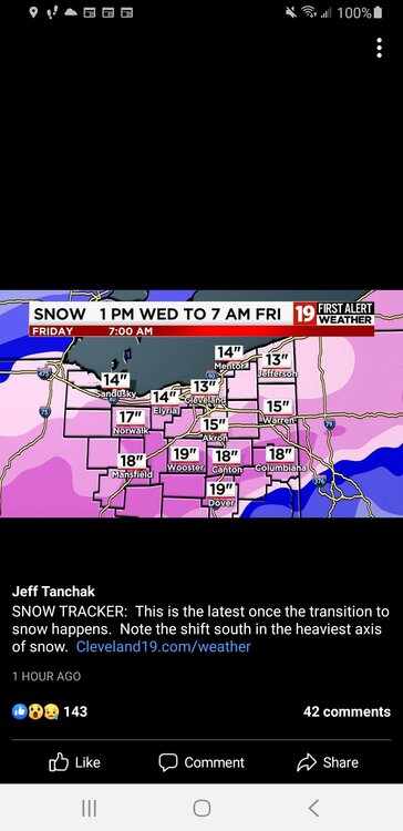
Damn…and his foot line is IMBY.
I wouldnt look too much into it even if he is a good met. Our locals lose attention to detail quickly when it’s out of the viewing area.
-
5 minutes ago, Ahoff said:
Saw the WSW was hoisted and Ron Smiley was saying he was expecting more snow than what was forecasted. He's usually rather conservative, but pretty good about totals, so that's interesting. Figured that meant the models went in our favor.
They were taking victory laps left and right in the MLK storm, even though the total fell within every outlets range.
If they want to score a win though, this might be the storm to do it. Somewhere from PGH to the NW figures to really cash in. But it would be a bold call at this point to slide 6”+ type totals into the city.
-
Might not translate to snow output, but the high presses east a little quicker in NAM. Good trend. Verbatim still probably a helluva sleet storm.
-
1
-
-
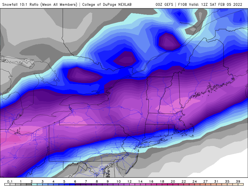
GEFS lookin better.
-
1
-
-
6 minutes ago, RitualOfTheTrout said:
Alright…wtf… who stole the GFS super computer cluster and is running it in their basement with modified physics code?
It can’t be this different from the rest and be correct can it? Lol
That counts a lot of sleet as 10:1 snow, especially in Kentucky and Southern Ohio. But if we can get that warm layer out..
Pittsburgh/Western PA Banter & Complaint Thread
in Upstate New York/Pennsylvania
Posted
Lol - been snowing the whole time they been arguing