

Burghblizz
-
Posts
1,742 -
Joined
-
Last visited
Content Type
Profiles
Blogs
Forums
American Weather
Media Demo
Store
Gallery
Everything posted by Burghblizz
-

Pittsburgh/Western PA Winter 2024-2025 Thread
Burghblizz replied to Rd9108's topic in Upstate New York/Pennsylvania
Nice. Solid 5-7” in the southern counties. I guess we knew the rapid drop off was a possibility. -
Pittsburgh/Western PA Winter 2024-2025 Thread
Burghblizz replied to Rd9108's topic in Upstate New York/Pennsylvania
Caught a couple sneaky heavy bands on the very tail end. Obviously a dud based on time invested, but a decent day. I may have close to 2” now for the day. Interesting to see how that translates to some areas that already did pretty well. Think it could bump the totals to 5-6” in spots in Fayette and Greene. -
Pittsburgh/Western PA Winter 2024-2025 Thread
Burghblizz replied to Rd9108's topic in Upstate New York/Pennsylvania
Almost reminds me of Lake Effect right now. Been snowing moderately for about 30 min…but starting to see a little sun trying to poke through -
Pittsburgh/Western PA Winter 2024-2025 Thread
Burghblizz replied to Rd9108's topic in Upstate New York/Pennsylvania
Seeing 2-3” reports already south of the city into northern WV. Probably just about .5” for me so far. FRZ reported near Morgantown and Accumulating snow in Cleveland. If someone told me that I’d say we were sitting pretty. But radar looks really disjointed. Just a different overall look than I expected. -
My guess is that they said something to the effect of the snow being heavier “south of Hershey”, and it got translated into literally falling apart as it goes through there.
-
Pittsburgh/Western PA Winter 2024-2025 Thread
Burghblizz replied to Rd9108's topic in Upstate New York/Pennsylvania
NAM a tick back north. I do think most of Mon Valley is looking pretty good. Just don’t feel great about where I sit. -
Palmyra have a snow shield that causes snow to diminish in that 3 or 4 miles?
-
Pittsburgh/Western PA Winter 2024-2025 Thread
Burghblizz replied to Rd9108's topic in Upstate New York/Pennsylvania
Hopefully that translates east and doesn’t get chewed up by dry air -
Pittsburgh/Western PA Winter 2024-2025 Thread
Burghblizz replied to Rd9108's topic in Upstate New York/Pennsylvania
Let’s go HRRR https://x.com/burgwx/status/1875952478589788617?s=46&t=nIoI0c7NSX6uBBZqtNsThg -
Pittsburgh/Western PA Winter 2024-2025 Thread
Burghblizz replied to Rd9108's topic in Upstate New York/Pennsylvania
Is that northern edge hitting the ground? -
Pittsburgh/Western PA Winter 2024-2025 Thread
Burghblizz replied to Rd9108's topic in Upstate New York/Pennsylvania
18Z NAM looks a smidge snowier. Edit: taken literally maybe less snowy as in the city but introducing more of the 12”+ stuff just south. Probably not great to split hairs over it anyway -
Bring it! (This time anyway)
-
Pittsburgh/Western PA Winter 2024-2025 Thread
Burghblizz replied to Rd9108's topic in Upstate New York/Pennsylvania
Tolleris’s map is horrible and he used to think Pgh was in Westmoreland County. But he has been decent over the years in terms of cutting through model differences and understanding which may win. If so - still in it. (Although not sure what is supposed to happen above the 6” because I live right above it - lol)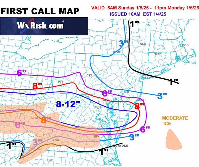
-
I could see him doing this 20 years ago - but you would think now there are some pretty easily available tools to shade in a map.
-
Pittsburgh/Western PA Winter 2024-2025 Thread
Burghblizz replied to Rd9108's topic in Upstate New York/Pennsylvania
This is normally the time the short term models start punching a little north to slop on our parade. This time it would help. -
Pittsburgh/Western PA Winter 2024-2025 Thread
Burghblizz replied to Rd9108's topic in Upstate New York/Pennsylvania
Would probably rather have that heavier shield creeping north like that even if the top end is lower. -
Pittsburgh/Western PA Winter 2024-2025 Thread
Burghblizz replied to Rd9108's topic in Upstate New York/Pennsylvania
Couple reports of 4”+ within about 5 miles of me. Great day IMBY, but im probably closer to 3” -
Pittsburgh/Western PA Winter 2024-2025 Thread
Burghblizz replied to Rd9108's topic in Upstate New York/Pennsylvania
NAM is stronger and a tick better. Gradient is tight. Probably rather be in Morgantown than Cranberry but showing 12-18” 30 miles either side of M/D -
Means business. Wind driven and close to whiteout here.
-
Pittsburgh/Western PA Winter 2024-2025 Thread
Burghblizz replied to Rd9108's topic in Upstate New York/Pennsylvania
Squall has arrived! Close to a whiteout. About 2” on the day. -
Pittsburgh/Western PA Winter 2024-2025 Thread
Burghblizz replied to Rd9108's topic in Upstate New York/Pennsylvania
I can’t count how many times the Euro has jumped 50-100 miles north (to give us slop) within 48 hours. It’s payback time. -
Pittsburgh/Western PA Winter 2024-2025 Thread
Burghblizz replied to Rd9108's topic in Upstate New York/Pennsylvania
It a smidge north from 6z -
Pittsburgh/Western PA Winter 2024-2025 Thread
Burghblizz replied to Rd9108's topic in Upstate New York/Pennsylvania
This swath this morning has been on lighter side, but steady. Sitting on about an inch already. Interesting to see how things set up later. -
Pittsburgh/Western PA Winter 2024-2025 Thread
Burghblizz replied to Rd9108's topic in Upstate New York/Pennsylvania
That’s why I was a little less worried about tongue. Just seemed to be a lot of guidance south. Also more W-E orientation and transfer that happens south. Still don’t hate where we sit. -
Pittsburgh/Western PA Winter 2024-2025 Thread
Burghblizz replied to Rd9108's topic in Upstate New York/Pennsylvania
Usually the opposite - which makes it kind of funny.


