

Burghblizz
-
Posts
1,742 -
Joined
-
Last visited
Content Type
Profiles
Blogs
Forums
American Weather
Media Demo
Store
Gallery
Everything posted by Burghblizz
-

Pittsburgh, Pa Winter 2023-24 Thread.
Burghblizz replied to meatwad's topic in Upstate New York/Pennsylvania
Airport looks like it’s been catching the northern fringe of the band. 1.5” in the last two hours, with 2” total. Steubenville/Wintersville area is about 25 miles southwest and is pushing 6”. Some of those types of totals will likely translate east. Definitely a nowcast storm. Certainly looked like the sweet spot would be further south. -
Pittsburgh, Pa Winter 2023-24 Thread.
Burghblizz replied to meatwad's topic in Upstate New York/Pennsylvania
Totals in eastern Ohio are going to be interesting. Places near Steubenville with 4” and a good bit to go. I saw about 2” downtown already but not a lot of reports from the western suburbs yet. Figure some folks there are doing well. -
Pittsburgh, Pa Winter 2023-24 Thread.
Burghblizz replied to meatwad's topic in Upstate New York/Pennsylvania
Band in Ohio getting thicker. Hoping that can swing north a little. I got into a little heavier snow, but mostly on the outside looking in still. About a half inch so far -
Pittsburgh, Pa Winter 2023-24 Thread.
Burghblizz replied to meatwad's topic in Upstate New York/Pennsylvania
Downtown getting drilled -
Pittsburgh, Pa Winter 2023-24 Thread.
Burghblizz replied to meatwad's topic in Upstate New York/Pennsylvania
Big fan of rates and daytime. Daytime is definitely out, but at least it looks like it won’t be in the middle of the night. I think south of the city still looks really good. I’m a little worried we northern people might not quite get the heavy stuff, but we’ll see. The 2:00 advisory update now advertising “3-5 with locally higher along route 70” -
Pittsburgh, Pa Winter 2023-24 Thread.
Burghblizz replied to meatwad's topic in Upstate New York/Pennsylvania
Models (and now radar) have shown this northern tongue of sorts that looks to get the precip going sooner. Will be interesting to see where this sets up, as it could help with some of the totals along the northern side of this. -
Pittsburgh, Pa Winter 2023-24 Thread.
Burghblizz replied to meatwad's topic in Upstate New York/Pennsylvania
Weenie band getting thicker. I still think the best energy is probably south of this depiction locally, but will be an interesting nowcast this evening. Westmoreland pounded on the run.p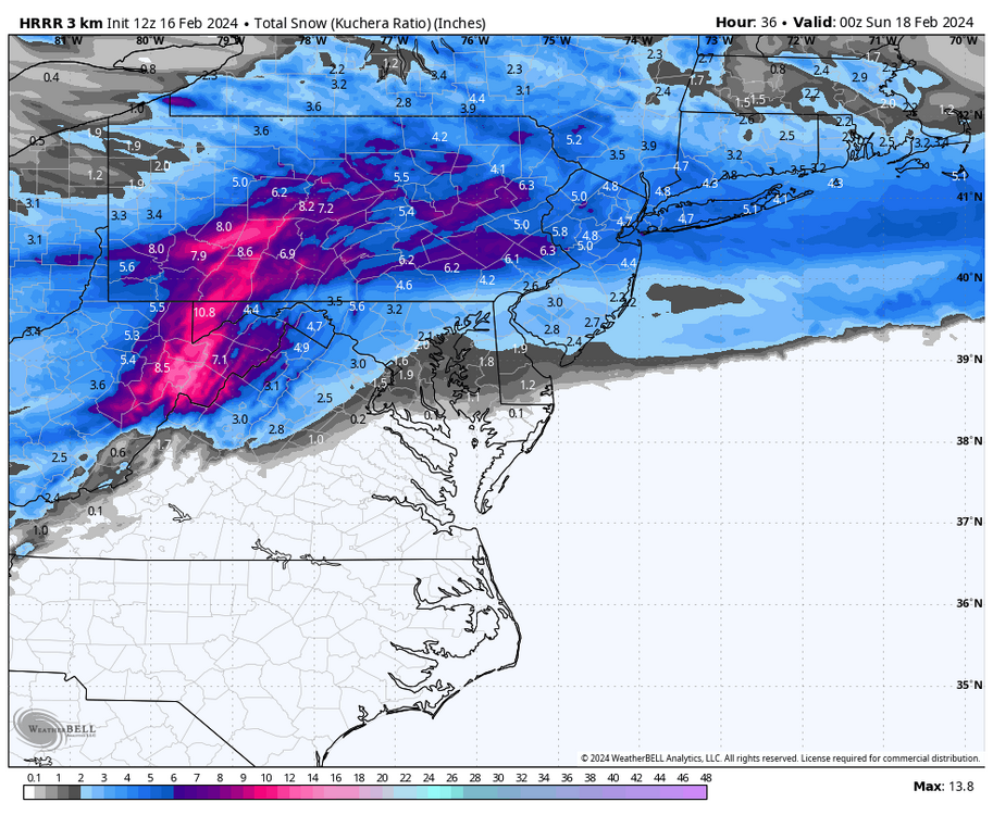
-
Pittsburgh, Pa Winter 2023-24 Thread.
Burghblizz replied to meatwad's topic in Upstate New York/Pennsylvania
HRRR Weenie band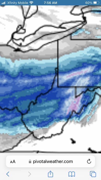
-
Pittsburgh, Pa Winter 2023-24 Thread.
Burghblizz replied to meatwad's topic in Upstate New York/Pennsylvania
I’m probably a touch north for this, but thinking there are some sweet spots (4”+) in the south hills or Westmoreland county. Basically far enough north to catch some better ratios, but far enough south to catch higher precip amounts. -
Pittsburgh, Pa Winter 2023-24 Thread.
Burghblizz replied to meatwad's topic in Upstate New York/Pennsylvania
03Z RAP depiction is in the north camp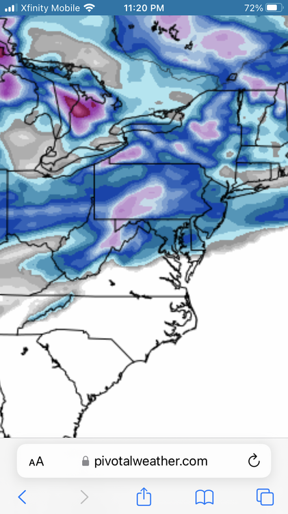
-
Pittsburgh, Pa Winter 2023-24 Thread.
Burghblizz replied to meatwad's topic in Upstate New York/Pennsylvania
Probably out to lunch with the totals, but that banding is interesting. Maybe some localized jackpot areas. -
Pittsburgh, Pa Winter 2023-24 Thread.
Burghblizz replied to meatwad's topic in Upstate New York/Pennsylvania
South of town looking good. -
Pittsburgh, Pa Winter 2023-24 Thread.
Burghblizz replied to meatwad's topic in Upstate New York/Pennsylvania
Great call outs. It’s easy to look at the surface and where the precip is depicted, but it’s the upper levels that drives it. -
Pittsburgh, Pa Winter 2023-24 Thread.
Burghblizz replied to meatwad's topic in Upstate New York/Pennsylvania
I’ve lived that scenario(figuratively), and this isn’t quite that. Dec 2000 and March 2001 in Harrisburg, I lost 3’ of predicted snow at nowcast time. Some of our WTODs had that vibe too This one always had red flags. I spent a lot of time on it because the modeling was so interesting and would have been a fun threading of the needle. -
Pittsburgh, Pa Winter 2023-24 Thread.
Burghblizz replied to meatwad's topic in Upstate New York/Pennsylvania
The funny thing is we got a rare SE shift, just the precip seemed to vanish on the NW side. Crazy -
You mean 2000? I was in Harrisburg at the time. Sunny skies.
-
Sittin pretty
-
Pittsburgh, Pa Winter 2023-24 Thread.
Burghblizz replied to meatwad's topic in Upstate New York/Pennsylvania
Euro isn’t necessarily south like the NAM - it’s just a touch too warm in changing over the intial slug of moisture. It’s still close to being decent. -
Pittsburgh, Pa Winter 2023-24 Thread.
Burghblizz replied to meatwad's topic in Upstate New York/Pennsylvania
Calendar day is misleading. The 2 15”+ storms after 94 straddled calendar days. 2.5 and 2.6 of 2010 got 10+” each day I think. Also, most of us got real close to a foot 12.20 during the same day. I also got 13” in 12.03 (living in Penn Hills) during a single calendar day. Official total fell short, but eastern AGC got walloped in about 8 hours. We don’t always knock those out of the park, but they get a lot leaner as you head southwest down the Ohio river. -
Pittsburgh, Pa Winter 2023-24 Thread.
Burghblizz replied to meatwad's topic in Upstate New York/Pennsylvania
The average snow here is substantially more, but the big storm frequency is more than places to the south and west. It isn’t just the lake enhancement. Some of you guys are always looking to the ridges, the snow belt, and New England and saying woe is us. But we get substantially more synomptic snow than places to the south and places at this latitude to the west. So the criteria is appropriate even if the last 2 years have sucked. -
Pittsburgh, Pa Winter 2023-24 Thread.
Burghblizz replied to meatwad's topic in Upstate New York/Pennsylvania
GFS another a tick better. -
Pittsburgh, Pa Winter 2023-24 Thread.
Burghblizz replied to meatwad's topic in Upstate New York/Pennsylvania
Congrats Morgantown I guess… -
Pittsburgh, Pa Winter 2023-24 Thread.
Burghblizz replied to meatwad's topic in Upstate New York/Pennsylvania
With all the uncertainty, let’s go with a blend for now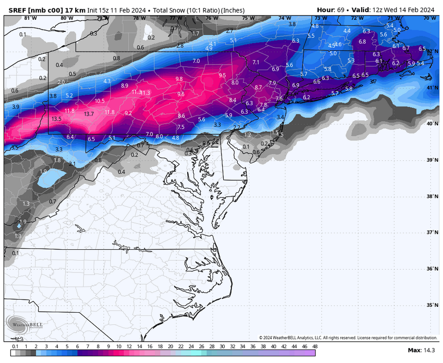
-
Pittsburgh, Pa Winter 2023-24 Thread.
Burghblizz replied to meatwad's topic in Upstate New York/Pennsylvania
I guess I’m right on their 3” line- but honestly this is easily the most nowcast event of the year. The NAM also looks like it’s going to slide a little too far SE, but the GFS will be along shortly with it’s too far NW solution. -
Pittsburgh, Pa Winter 2023-24 Thread.
Burghblizz replied to meatwad's topic in Upstate New York/Pennsylvania
I think that’s the UK with the legend off as well. I think that light blue is really 2-4 not 4-6 (and so on)


