

Burghblizz
-
Posts
1,742 -
Joined
-
Last visited
Content Type
Profiles
Blogs
Forums
American Weather
Media Demo
Store
Gallery
Everything posted by Burghblizz
-

Pittsburgh/Western PA Winter 2024-2025 Thread
Burghblizz replied to Rd9108's topic in Upstate New York/Pennsylvania
I think some of the rural areas get to -15. -
Pittsburgh/Western PA Winter 2024-2025 Thread
Burghblizz replied to Rd9108's topic in Upstate New York/Pennsylvania
-6 IMBY Seeing as low as -11 close by on WeatherBug. Curious to see what some of these rural places show tomorrow morning. -
Pittsburgh/Western PA Winter 2024-2025 Thread
Burghblizz replied to Rd9108's topic in Upstate New York/Pennsylvania
Got 3.5” total last night. Didn’t happen exactly the way I thought, but definitely did the job of freshening up the snowpack. -
Pittsburgh/Western PA Winter 2024-2025 Thread
Burghblizz replied to Rd9108's topic in Upstate New York/Pennsylvania
Another nice band dropping into SW Butler county and entering northern AGC. i got a coating of pixie dust off the initial system, but probably will be close to 3” total off these LES bands. -
Pittsburgh/Western PA Winter 2024-2025 Thread
Burghblizz replied to Rd9108's topic in Upstate New York/Pennsylvania
POUNDING here. 2” last hour -
Pittsburgh/Western PA Winter 2024-2025 Thread
Burghblizz replied to Rd9108's topic in Upstate New York/Pennsylvania
Mailman and Chalk Hill look to be getting the good stuff -
Pittsburgh/Western PA Winter 2024-2025 Thread
Burghblizz replied to Rd9108's topic in Upstate New York/Pennsylvania
This “higher end” product is something.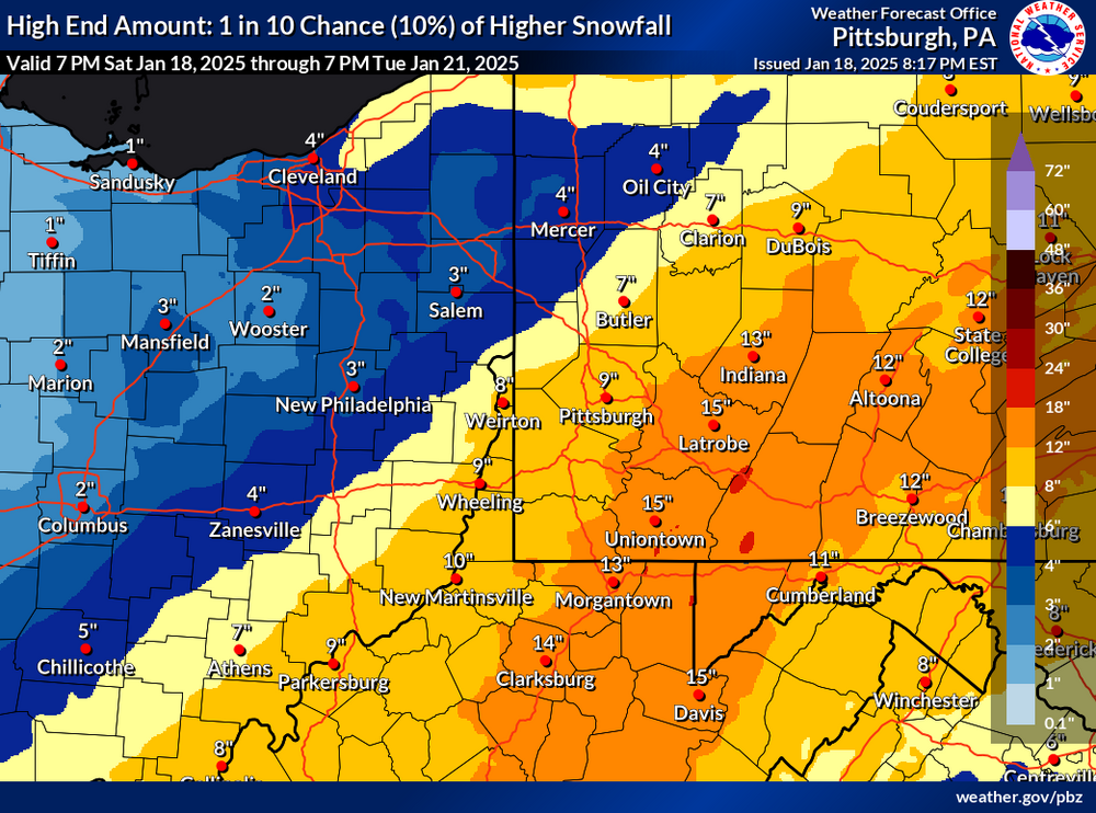
-
Pittsburgh/Western PA Winter 2024-2025 Thread
Burghblizz replied to Rd9108's topic in Upstate New York/Pennsylvania
NAM giving Mon Valley a chance. -
Pittsburgh/Western PA Winter 2024-2025 Thread
Burghblizz replied to Rd9108's topic in Upstate New York/Pennsylvania
So basically Canada against the world Sunday. Haven’t put a lot into that, so that would be a huge bonus if it verifies -
Pittsburgh/Western PA Winter 2024-2025 Thread
Burghblizz replied to Rd9108's topic in Upstate New York/Pennsylvania
Yeah - I saw some yellow popping on radar (then watched it slide south of me) -
Pittsburgh/Western PA Winter 2024-2025 Thread
Burghblizz replied to Rd9108's topic in Upstate New York/Pennsylvania
Is your house on one of the runways at the airport? There has been a lot of localized banding during this period, and one decent storm that had a sharp cutoff. I’m probably around 18-20” for the season here. -
Pittsburgh/Western PA Winter 2024-2025 Thread
Burghblizz replied to Rd9108's topic in Upstate New York/Pennsylvania
It going to pivot to be more snow showers and less uniform. Looks like the first decent band incoming. -
Pittsburgh/Western PA Winter 2024-2025 Thread
Burghblizz replied to Rd9108's topic in Upstate New York/Pennsylvania
Meanwhile - it’s thumping now -
Pittsburgh/Western PA Winter 2024-2025 Thread
Burghblizz replied to Rd9108's topic in Upstate New York/Pennsylvania
Good NWS discussion today. Basically saying that even though there may not be a widespread 3” average to meet advisory criteria, the cold temps along with Tuesdays road issues helped build the case. It should be flexible based on impact. I think we see a high floor with totals today(2+). Good ratios, and interested to see if there is banding later. -
Pittsburgh/Western PA Winter 2024-2025 Thread
Burghblizz replied to Rd9108's topic in Upstate New York/Pennsylvania
Nothing major, but daytime snow on snow is nice. -
Pittsburgh/Western PA Winter 2024-2025 Thread
Burghblizz replied to Rd9108's topic in Upstate New York/Pennsylvania
It has snowed every day in January so far. -
Pittsburgh/Western PA Winter 2024-2025 Thread
Burghblizz replied to Rd9108's topic in Upstate New York/Pennsylvania
I think preparation is still a function of total snow forecasted. Usually a forecast of an inch or two has pretty minimal resources needed. But having it fall steadily over 4 hours when it’s 15 degrees is something different. Not sure if they just look at forecasts or actually consult with someone. Steady rates, low temps, and rush hour, should be treated with a little more urgency than a typical 1-2” snowfall. -
Pittsburgh/Western PA Winter 2024-2025 Thread
Burghblizz replied to Rd9108's topic in Upstate New York/Pennsylvania
Went out to eat in Cranberry tonight. Looked like a full fledged snowstorm for awhile Roads were horrible. Really only a slight over performer - but with temps around 15 everything is sticking. People are complaining that the “weather people don’t know what they are doing” - lol. We are probably somewhere between 1.5-2”, with a forecast of an inch. But the decent rates and cold temps made a huge difference. -
Pittsburgh/Western PA Winter 2024-2025 Thread
Burghblizz replied to Rd9108's topic in Upstate New York/Pennsylvania
Nice fresh inch here. Definitely every flake counting with temps in the teens. -
Pittsburgh/Western PA Winter 2024-2025 Thread
Burghblizz replied to Rd9108's topic in Upstate New York/Pennsylvania
Up to about 2.5”. Still snowing, but with peaks of sun, the accumulating snow looks to be over here. -
Pittsburgh/Western PA Winter 2024-2025 Thread
Burghblizz replied to Rd9108's topic in Upstate New York/Pennsylvania
I wound up with about 2” new. Too bad it fell at night. Would have been nice with snow on snow. -
Pittsburgh/Western PA Winter 2024-2025 Thread
Burghblizz replied to Rd9108's topic in Upstate New York/Pennsylvania
Crazy that someone might pop 6” out of this and it wound up being north -
Pittsburgh/Western PA Winter 2024-2025 Thread
Burghblizz replied to Rd9108's topic in Upstate New York/Pennsylvania
I don’t know - it’s thumping pretty good here relatively speaking. Pushing an inch and it really just started here around 7:30. Roads covered. Snowpack freshened up .Nice night overall. -
Pittsburgh/Western PA Winter 2024-2025 Thread
Burghblizz replied to Rd9108's topic in Upstate New York/Pennsylvania
1 degree IMBY. Clear skies and snow pack did some work last night. -
Pittsburgh/Western PA Winter 2024-2025 Thread
Burghblizz replied to Rd9108's topic in Upstate New York/Pennsylvania
I think these stretches are still quite common in an average to good winter here. How else would we average 40”+ while whiffing on big storms.

