

Burghblizz
-
Posts
1,742 -
Joined
-
Last visited
Content Type
Profiles
Blogs
Forums
American Weather
Media Demo
Store
Gallery
Everything posted by Burghblizz
-

Pittsburgh/Western PA Winter 2024-2025 Thread
Burghblizz replied to Rd9108's topic in Upstate New York/Pennsylvania
Low still passing south and transferring - so I would think any tongue flirtations are brief. -
Pittsburgh/Western PA Winter 2024-2025 Thread
Burghblizz replied to Rd9108's topic in Upstate New York/Pennsylvania
Agree with taking them one at a time - I’ll enjoy whatever falls. I remember occasions over the years where people were bickering about bigger storms falling apart on the models, while it was snowing 2-3” that day :-) -
Pittsburgh/Western PA Winter 2024-2025 Thread
Burghblizz replied to Rd9108's topic in Upstate New York/Pennsylvania
Looks like 3”-4” so far Beaver co, SW Butler co, and down into the North Hills Franklin Park winner so far. 5” -
Pittsburgh/Western PA Winter 2024-2025 Thread
Burghblizz replied to Rd9108's topic in Upstate New York/Pennsylvania
2” so far IMBY mostly since 8:00. -
Pittsburgh/Western PA Winter 2024-2025 Thread
Burghblizz replied to Rd9108's topic in Upstate New York/Pennsylvania
I was thinking the same. Wouldn’t have been disruptive but looked great. Streamers look to mean business this morning -
Pittsburgh/Western PA Winter 2024-2025 Thread
Burghblizz replied to Rd9108's topic in Upstate New York/Pennsylvania
1.5” this morning with no tracking invested. Sticking to everything. Nice little “free” snow. -
Pittsburgh/Western PA Winter 2024-2025 Thread
Burghblizz replied to Rd9108's topic in Upstate New York/Pennsylvania
Nice backend thump here. Smidge too warm for concrete, and might only last a couple hours. But looks nice aht! -
Pittsburgh, PA Fall 2024 Thread
Burghblizz replied to TheClimateChanger's topic in Upstate New York/Pennsylvania
Probably rip and read from a GFS run. -
Pittsburgh, Pa Summer 2024 Thread.
Burghblizz replied to meatwad's topic in Upstate New York/Pennsylvania
This stretch is still impressive in its length of warmth for early season, but not so much in its extremes. I think I’m at like 86 right now. Storms Monday were no joke. I didn’t see any official wind gusts, and I don’t have a weather station. We had to be over 70 MPH gusts in Cranberry. Can’t remember the last time I’ve seen wind driven rain like that. -
Pittsburgh/Western PA Spring 2024
Burghblizz replied to Ahoff's topic in Upstate New York/Pennsylvania
If we could only get this kind of training and efficiency for a snowstorm. -
Pittsburgh/Western PA Spring 2024
Burghblizz replied to Ahoff's topic in Upstate New York/Pennsylvania
Haha - I did say that. For a bunch of years it was the NFL equivalent of having non-losing seasons and losing in the playoffs. Got snow, but missed in the big games (storms). My positive spin was that at least we are practically guaranteed 20”+ regardless of how bad it was. At that point, it had happened maybe 1-2 times in 40 years. The funny thing is in the last 6-7 years we’ve had a decent group of 8-12” storms. The lack of those for a while was causing a lot of whining. But obviously 3 seasons in that period have been historically low overall. -
Pittsburgh/Western PA Spring 2024
Burghblizz replied to Ahoff's topic in Upstate New York/Pennsylvania
I remember looking real close to make sure the white area made it all the way to the Ohio line (in retrospect, it was understated) -
Pittsburgh/Western PA Spring 2024
Burghblizz replied to Ahoff's topic in Upstate New York/Pennsylvania
We’d be panicking that shit was sliding east -
Pittsburgh/Western PA Spring 2024
Burghblizz replied to Ahoff's topic in Upstate New York/Pennsylvania
Ironically, probably 5 miles south of there got another 7-8”. (Which isn’t a ton, but for this year it will be decent % of the total) -
Pittsburgh/Western PA Spring 2024
Burghblizz replied to Ahoff's topic in Upstate New York/Pennsylvania
I technically have this for tomorrow which is one of the more aggressively worded headlines all winter. I have to think though this is more intended for the northern half of the Butler County. Can’t see this being too great in Cranberry, but I wouldn’t mind some nice squalls.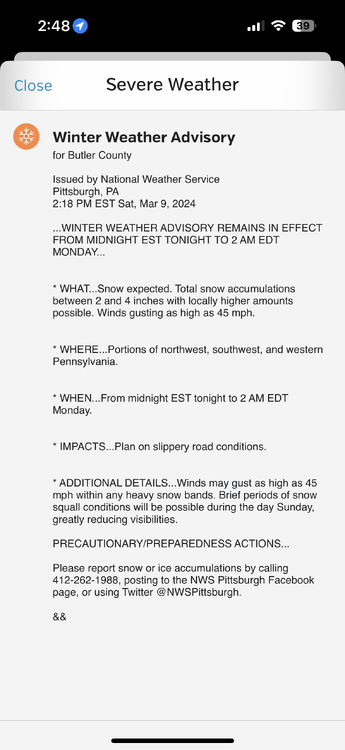
-
Pittsburgh, Pa Winter 2023-24 Thread.
Burghblizz replied to meatwad's topic in Upstate New York/Pennsylvania
A 50” February wasn’t *that* long ago. Also, what followed was 5 or 6 above average snowfall Februarys in a row - getting well into mid 2010s. At that point one could have said they are becoming snowier than January. Two bad years doesn’t mean winter has changed. 2022 was the snowiest March since ‘93. And like I have said - this isn’t disputing the overall impact of climate change. But local sensible weather (esp pertaining to snow) needs a lot more data to conclude anything anytime soon. At this point - it’s just two bad winters. -
Pittsburgh, Pa Winter 2023-24 Thread.
Burghblizz replied to meatwad's topic in Upstate New York/Pennsylvania
Wouldn’t be shocked to see an inch or two along the I70 corridor this morning. Healthy little batch of steady snow. That was modeled way south a few days ago -
Pittsburgh, Pa Winter 2023-24 Thread.
Burghblizz replied to meatwad's topic in Upstate New York/Pennsylvania
He still has this as his “pinned tweet”. Kind of silly at this point. Have to hope for a strong March. -
Pittsburgh, Pa Winter 2023-24 Thread.
Burghblizz replied to meatwad's topic in Upstate New York/Pennsylvania
Rippin here right now. Heaviest I’ve personally seen since yesterday. Great morning (although, not gonna lie, jealous of 6-7” 20 miles away) -
Pittsburgh, Pa Winter 2023-24 Thread.
Burghblizz replied to meatwad's topic in Upstate New York/Pennsylvania
Seeing also 6+ in Plum too. Which basically means that band…cutting through the center of the entire length of Allegheny County will wind up dropping 6-8”. Even though that cuts through a pretty populated swath, not sure we have a ton of posters that got to enjoy it full on. But still a pretty remarkable event. -
Pittsburgh, Pa Winter 2023-24 Thread.
Burghblizz replied to meatwad's topic in Upstate New York/Pennsylvania
It was kind of fringed, and the NWS is on Shafer road with is even a touch north from there. -
Pittsburgh, Pa Winter 2023-24 Thread.
Burghblizz replied to meatwad's topic in Upstate New York/Pennsylvania
Imperial - literally 5 miles from the airport. 6.5”. If I recall, they got the lake band too. People there are probably thinking it ain’t a bad winter -
It’s a pretty narrow band, it just happens to be going right through the city. Places west of the city into eastern Ohio have 6-10”. Outside of the mega band, I think we are looking at more like a widespread 2-4”.
-
Pittsburgh, Pa Winter 2023-24 Thread.
Burghblizz replied to meatwad's topic in Upstate New York/Pennsylvania
The mesos did have some weenie bands, but not in that area. Was further south and east. -
Pittsburgh, Pa Winter 2023-24 Thread.
Burghblizz replied to meatwad's topic in Upstate New York/Pennsylvania
Correction - 7” already in Steubenville


