Burghblizz
-
Posts
1,742 -
Joined
-
Last visited
Content Type
Profiles
Blogs
Forums
American Weather
Media Demo
Store
Gallery
Everything posted by Burghblizz
-

Pittsburgh, Pa Winter 2023-24 Thread.
Burghblizz replied to meatwad's topic in Upstate New York/Pennsylvania
Good assessment. I’m going to try to enjoy some longer walks with the dog, and hope for a kick ass final 5-6 weeks. -
Pittsburgh, Pa Winter 2023-24 Thread.
Burghblizz replied to meatwad's topic in Upstate New York/Pennsylvania
March ‘22 had an 8” ish storm around around the 12th, and then a very active LES pattern even into the latter part of the month. So it was a good month, although lots of melting in between events. But hey, it was March. Other thing I remember is someone (I think Ahoff) started a spring thread in February since it was sucking. Must have worked as a reverse jinx as we finished strong. Threaded the needle nicely on the bigger storm as this long area of precip trained for awhile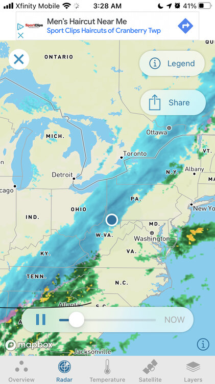
-
Pittsburgh, Pa Winter 2023-24 Thread.
Burghblizz replied to meatwad's topic in Upstate New York/Pennsylvania
Funny how the NAM is a cold outlier. Not sure if maybe it’s overdoing the rates leading to more dynamic cooling. But it’s been consistently showing that backend snow. -
You made me look. I’d be happy to wait 9 days for a 970mb retrograding bomb.
-
Pittsburgh, Pa Winter 2023-24 Thread.
Burghblizz replied to meatwad's topic in Upstate New York/Pennsylvania
NAM is most aggressive with a period changing to snow tomorrow. Has been liking North and West of city. Taken literally, about 4” at KPIT. Probably won’t be able to thread the needle like that, and surface temps will likely be above freezing. Something to watch though. -
Maybe just start your own thread where you can dump whatever statistics you want for wherever you want. If it’s the warmest day that the neighbors dog took a shit facing south, you don’t have to worry about it being irrelevant.
-
Pittsburgh, Pa Winter 2023-24 Thread.
Burghblizz replied to meatwad's topic in Upstate New York/Pennsylvania
That would be surprising. Because it feels like we got our snows in smaller chunks over the last 20 years (with a few big exceptions like 2.10 and 12.20). That would in theory need more frequent snows to keep the averages up. -
Pittsburgh, Pa Winter 2023-24 Thread.
Burghblizz replied to meatwad's topic in Upstate New York/Pennsylvania
You’re not wrong. Fewer clippers, more flirting with mix. There have been subtle changes. Maybe offset by more extended LES nuisance snows. But I think 2023 is a blip. There have been plenty before. Talking warm temps last night and today is very relevant. But Dozens (if not hundreds) of posts that build towards some narrative that our overall snow is dying is the clutter I’m talking about. Nothing in the long term data shows that. -
Pittsburgh, Pa Winter 2023-24 Thread.
Burghblizz replied to meatwad's topic in Upstate New York/Pennsylvania
Funny how you think you understand my “politics”. Definitely a different person than your “assumptions”, and not in any way disputing the science. I’m just sick of a formally great thread cluttered with it when…again…local sensible weather will go through cycles. -
Pittsburgh, Pa Winter 2023-24 Thread.
Burghblizz replied to meatwad's topic in Upstate New York/Pennsylvania
Wait - time out. Not sure who you “some of you” are. I have no issues with “climate change talk”. I have issues with the flat out obsession of a poster (or three) obsessing over every slice of data that might show a a degree or two warmer for *this* area. Local sensible weather (esp snowfall) has not declined here over extended periods For 15+ years (going back to eastern), this thread has been about winter storm chasing. Sure we can acknowledge if it’s warm, etc. But some weird slice of data everyday? I mean look at the Buffalo thread from last year. Climate Changer had 9 posts in a row about Lake Erie being a half degree warmer or some shit. Those guys went to Discord. They want to talk about chasing their 2-4’ lake band. So again…it’s not about the topic or the science. It’s about the place and frequency. -
Pittsburgh, Pa Winter 2023-24 Thread.
Burghblizz replied to meatwad's topic in Upstate New York/Pennsylvania
No one cares -
While gambling and winter seasons are both “independent trials” as far as what happens next, I think both have long term expected outcomes. Red and black on Roulette will come up the same % over the very long term. Pittsburgh will get 44” of snow a year over the long term. And while there are broader climate considerations at play, there hasn’t been an extended period of time where those averages have significantly changed here. So I do think “payback is coming”. It’s worked that way throughout the period of recorded weather history.
-
Pittsburgh, Pa Winter 2023-24 Thread.
Burghblizz replied to meatwad's topic in Upstate New York/Pennsylvania
Euro is not quite there…but close. 6-7” from 422 north. Foot plus north central Pa. Considerably east versus yesterday with snow significantly farther south. Another shift like that and we’re in. Unfortunately, not the direction you would expect the Euro to shift, but worth watching. -
Pittsburgh, Pa Winter 2023-24 Thread.
Burghblizz replied to meatwad's topic in Upstate New York/Pennsylvania
I had 9” in Monroeville March 2013 as well. Maybe this underperformed at the airport, but this was another nice March storm. So I wouldn’t say the few years after 2010 had nothing, just these memories tend to fade quicker than huge storms.
-
Pittsburgh, Pa Winter 2023-24 Thread.
Burghblizz replied to meatwad's topic in Upstate New York/Pennsylvania
I don’t think the NWS frequency page is ever updated, and I never liked the way they do their end points. Ive stopped looking at it, but I think it had something like: 5”+’twice a year…. 8-12” once every 2 years….13”+ once every 14. So you can spin the expectancy of a 12” type storm a couple different ways, but a storm that pushes or exceeds double digits is about a once every 2 year thing historically. The good news is those solid 8-12” snowstorms that had been missing for a bunch of years have been better. I think we have 4 since 2018 (5 for some people that caught the lake band). So despite the horrible last 15 months, that is a positive overall. We are also officially due for a mega storm. -
Pittsburgh, Pa Winter 2023-24 Thread.
Burghblizz replied to meatwad's topic in Upstate New York/Pennsylvania
GFS is close to something for next Sunday. Good track - just not quite enough cold. Probably a good idea to put this one down for few days and just check back around Thursday Low probability as it looks now, but falling at peak climo for cold. -
Pittsburgh, Pa Winter 2023-24 Thread.
Burghblizz replied to meatwad's topic in Upstate New York/Pennsylvania
Even though I didn’t get that main band, it reminded me how much a love this. Sometimes tons of tracking doesn’t play out. But other times, you get something like that mesoscale feature that you would have never predicted 3 or 4 days out. -
And as far as overall “climate”…sure it’s changing. And it’s impacting some things. But we need a helluva lot more than a poor 18 month stretch to glean that our sensible “snow weather” is significantly different. The data just doesn’t show that. Our 30 year snow averages continue to go up. And that included a drought that happened in the early 90s. Then we cranked out 3 70” winters over the next 40 months. Climate change and “snowing a lot in Pgh” aren’t mutually exclusive, especially when viewed in our lifetimes.
-
NWS Weather “headlines” aren’t scores. They are just one services way to broadly communicate what they think will happen. We like watches and warnings as weather fans because it kind of validates our tracking. But no one in there right mind is going to check that 5 years from now. No one cares. People will however remember being stuck in 2” per hour rates. In fact, headlines are for “county averages”, not for one location. So clearly this was an event that averaged at least 4” in the county. It absolutely “verified” (which again, is just us talking, not some official score). If that band was 10 miles east and the kid working last night at NWS thought “hmm…I’m puttin up a warning for the county”, does that count as a WSW verified? Or no because half the county didn’t get it? This stuff can be spun either way. But it’s silly try to position it so it fits the trolling agenda. It was a good winter day for most…a great winter day for some.
-
Pittsburgh, Pa Winter 2023-24 Thread.
Burghblizz replied to meatwad's topic in Upstate New York/Pennsylvania
Go to banter with the trolling. Taking this thread back. Yesterday was fun with actual weather and weather conversations. Don’t need 30 more posts because a ruler missed by .1, or was 2 miles in the wrong spot. Clutter. -
Pittsburgh, Pa Winter 2023-24 Thread.
Burghblizz replied to meatwad's topic in Upstate New York/Pennsylvania
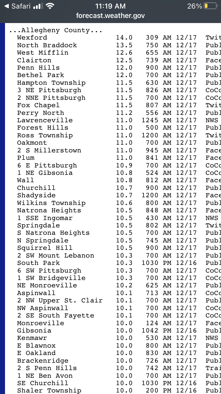
If u move to Philly, DC or Central Park, you can see 700 day stretches before seeing even an inch. 12 miles from the airport had 10” yesterday. So let’s not carry this stat forward anymore. If the official total got it, you would have said “well that doesn’t count because I didn’t get ituhhh” -
Pittsburgh, Pa Winter 2023-24 Thread.
Burghblizz replied to meatwad's topic in Upstate New York/Pennsylvania
December 2020 was a fairly widespread average that approached a foot.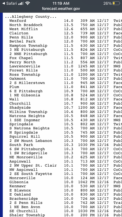
-
Pittsburgh, Pa Winter 2023-24 Thread.
Burghblizz replied to meatwad's topic in Upstate New York/Pennsylvania
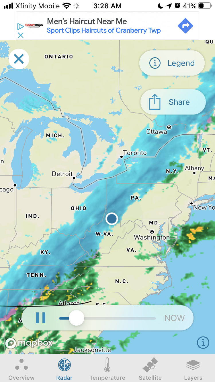
Spotter 2 miles from me reported 4.5”, so that’s what I’ll go with. Had 3.5” from main shield. Picked up about a half inch in about 20 minutes in the LES band. Then a little bit after that, including another littlep snow shower just now. -
Pittsburgh, Pa Winter 2023-24 Thread.
Burghblizz replied to meatwad's topic in Upstate New York/Pennsylvania
Funny how the bigger snows circumvented the weenies fighting and made it to some good posters. Maybe being positive will lead to better snows! -
Pittsburgh, Pa Winter 2023-24 Thread.
Burghblizz replied to meatwad's topic in Upstate New York/Pennsylvania
Just saw McMurray - 8.5” Havent seem an official KPIT total. What’s funny is I think the office is slightly north of the airport. And in watching the band, it may have mostly missed them even though it was snowing at the actual airport.