

Burghblizz
-
Posts
1,742 -
Joined
-
Last visited
Content Type
Profiles
Blogs
Forums
American Weather
Media Demo
Store
Gallery
Everything posted by Burghblizz
-
 It’s basically what I was getting at before. Very similar to the GFS, but it continues on and tracks over Det. Meanwhile, GFS reaches a similar point, but retrogrades to western Mich, becomes occluded, and gets the cold air quicker. So the more eastern track actually hurts unless we want to go all in and hope for a 500 mile shift east.
 -
Welcome! Your name seems appropriate for this week.
-
I don’t know, unless you guys are hoping for a Christmas miracle apps runner, not sure SE is what we want.
-
Not all cutters are created equal - I don’t think this is about willing it to the east. It’s more about intensity and timing. West could be best. We could have crashing temps with SW winds because of how wound up this is. Meanwhile, places just east of the track (including as far north as Ontario are raining). Different evolution, but our biggest storm ever (11.1950) did something similar. That’s why I think we have a better than normal chance of having more precip when the cold air gets there. The GFS then wants to retrograde it and prolong the snows. That’s what it basically gives us a foot. So no, it isn’t likely. And no it’s not Nov 1950. But I wouldn’t punt yet just because it cuts.
-
I think more backend than front… It cuts and cuts hard - but it wraps a lot of cold air around it with SLP way west - and a good slug of moisture still. Gives my backyard about 10” if taken literally, but also some far lessor amounts close by. Rain, rapid temp drop, maybe a flash freeze, and then a period of SN+ looks quite possible. Hard to be too excited when there is a raging blizzard in the Midwest, but does still have a chance to be eventful.
-
Probably not worth over analyzing 5 days out….and it’s definitely not perfect…but 0Z GFS is a step back in the right direction.
-
I know that it’s more complicated than this - but GFS has that “right where we want it” feel a week out. Foot just southeast…feet farther south east.
-
Fall 2022 Pittsburgh/Western PA Discussion
Burghblizz replied to Ahoff's topic in Upstate New York/Pennsylvania
Not really as far as actual Buffalo. Looks like the airport got a foot, but the city and places north have stopped snowing for quite some time. It’s south that will get the epic totals. I don’t think there are a lot of posters from actual in Buffalo here, but it would be interesting to see how a typical weenie would react to have 4 or 5’ 20 miles down the road and not get it. Our thread would be NUTS. I have to think most there would take it in stride just due to the nature of LES, AND the frequency of snow in general. -
Fall 2022 Pittsburgh/Western PA Discussion
Burghblizz replied to Ahoff's topic in Upstate New York/Pennsylvania
Just over 1” here, with the biggest fatties of the day coming. Roads coating up. -
Fall 2022 Pittsburgh/Western PA Discussion
Burghblizz replied to Ahoff's topic in Upstate New York/Pennsylvania
Thumping nicely…the usual colder surfaces are slushy/white. A few degrees colder this would be an easy couple inches. -
Pittsburgh/Western PA Spring 2022 Discussion Thread
Burghblizz replied to Ahoff's topic in Upstate New York/Pennsylvania
This setup is 24” in February. -
Pittsburgh/Western PA Spring 2022 Discussion Thread
Burghblizz replied to Ahoff's topic in Upstate New York/Pennsylvania
Poppin like crazy. Funnels spotted near Mcmurray, West Newton, and Penn Hills -
Central PA Spring 2022
Burghblizz replied to Itstrainingtime's topic in Upstate New York/Pennsylvania
Here yinz go on a revised map. No clue what they were doing the first time, outside of possibly using radar estimates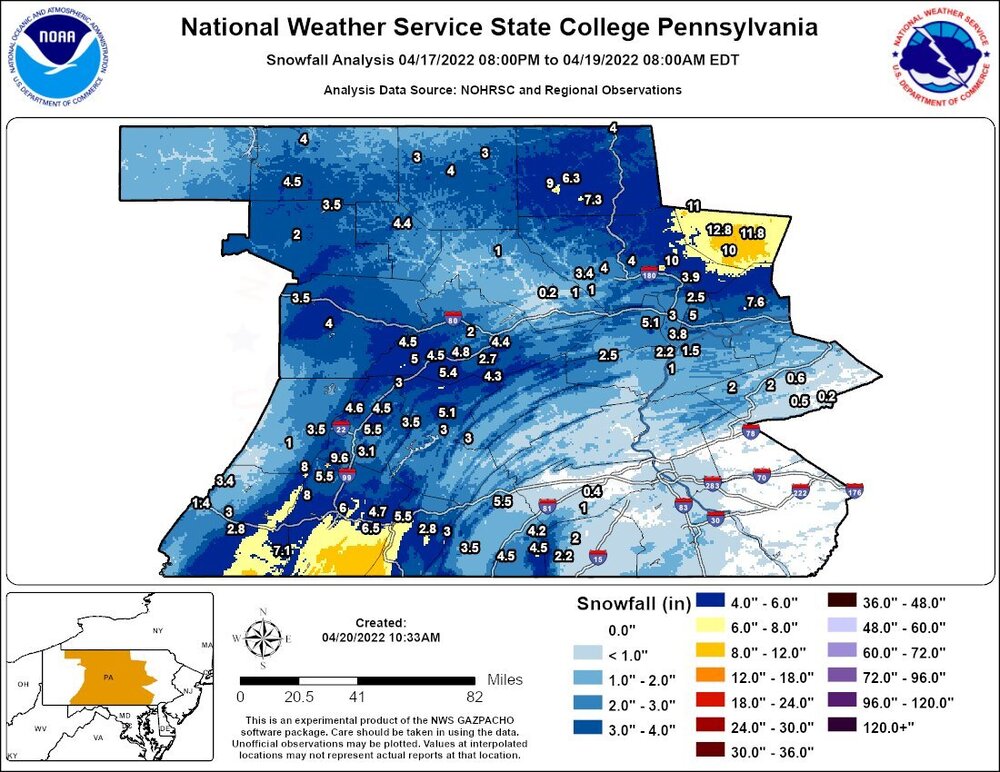
-
Western PA/Pittsburgh Winter 2021/22 Discussion
Burghblizz replied to meatwad's topic in Upstate New York/Pennsylvania
This band north of the city is thumpin. Training a bit too. After this, ready for some warmth. -
Western PA/Pittsburgh Winter 2021/22 Discussion
Burghblizz replied to meatwad's topic in Upstate New York/Pennsylvania
Mod snow right now. Mulch, grass, roofs, cars all have caved. Still really slushy though. Could use a couple degree temp drop. -
Western PA/Pittsburgh Winter 2021/22 Discussion
Burghblizz replied to meatwad's topic in Upstate New York/Pennsylvania
Snow/sleet mix now in Cranberry, after mostly rain this morning. (Edit: big fatties flying now) -
Pittsburgh/Western PA Spring 2022 Discussion Thread
Burghblizz replied to Ahoff's topic in Upstate New York/Pennsylvania
It’s going to be interesting for the northern suburbs, and especially into Butler/Beaver/Armstrong. Don’t think anyone actually gets the 3-6” NAM/GFS/Euro are saying, but wouldn’t be surprised to see some heavy falling snow, with grassy areas white. -
Pittsburgh/Western PA Spring 2022 Discussion Thread
Burghblizz replied to Ahoff's topic in Upstate New York/Pennsylvania
With all the chilly (and windy) weather, would be nice to cash in with some accumulating snow early next week. Otherwise, let’s keep it 60 and above. -
Western PA/Pittsburgh Winter 2021/22 Discussion
Burghblizz replied to meatwad's topic in Upstate New York/Pennsylvania
Winter Weather Advisory tommorow morning. Pushing 70 tomorrow afternoon. -
Western PA/Pittsburgh Winter 2021/22 Discussion
Burghblizz replied to meatwad's topic in Upstate New York/Pennsylvania
I grew up in Fayette county. We flipped back to snow and wound up close to a foot total. I think there was actually more warm air being pulled in to the north. But yes, what could have been. Went to bed with 6” on the ground, and woke up to a slushy mess and a flood watch. But got a bunch more after we changed back, so overall I have a good memory of it. -
This thread has been around for 8 years. Almost 30% of the posts in it were in the last 2 months. Despite all that, we made it to normal snowfall (44”) God help yinz if we ever have an 18” winter.
-
Western PA/Pittsburgh Winter 2021/22 Discussion
Burghblizz replied to meatwad's topic in Upstate New York/Pennsylvania
Another nice band dropping in. In terms of fallen snow, I’m about 5” since Saturday. Nice payback for some of that cold rain. -
Western PA/Pittsburgh Winter 2021/22 Discussion
Burghblizz replied to meatwad's topic in Upstate New York/Pennsylvania
For as bad as most of February was - cold but somehow mostly rainy - March has been awesome. Not great if you want extended snow cover, but March never is. But gotta love having plenty of mild days to get outside, mixed with days with heavy snow. -
Western PA/Pittsburgh Winter 2021/22 Discussion
Burghblizz replied to meatwad's topic in Upstate New York/Pennsylvania
Southeast Beaver, Southwest Butler, and extreme Northern AGC could probably use a headline. Still rippin’ -
Western PA/Pittsburgh Winter 2021/22 Discussion
Burghblizz replied to meatwad's topic in Upstate New York/Pennsylvania
Band is dumping again this morning. Easily got 3” the last 2 days (with of course complete melting in between)


