Burghblizz
-
Posts
1,742 -
Joined
-
Last visited
Content Type
Profiles
Blogs
Forums
American Weather
Media Demo
Store
Gallery
Everything posted by Burghblizz
-

Western PA/Pittsburgh Winter 2021/22 Discussion
Burghblizz replied to meatwad's topic in Upstate New York/Pennsylvania
I had about 1.5”, that got vaporized after it stopped. Nice little early morning treat though. -
Western PA/Pittsburgh Winter 2021/22 Discussion
Burghblizz replied to meatwad's topic in Upstate New York/Pennsylvania
Nice - yeah I saw that on radar - just scooting south or me. Edit: catching some of it now. Just snowed 1” in 20 minutes -
Western PA/Pittsburgh Winter 2021/22 Discussion
Burghblizz replied to meatwad's topic in Upstate New York/Pennsylvania
Looks like we will have the quantity of flakes to get that half inch - just depends on timing and rates. (And temps) -
Central PA - Winter 2021/2022
Burghblizz replied to Bubbler86's topic in Upstate New York/Pennsylvania
It’s the second thing I thought of - lol (right after thinking through how light winter mornings and evenings would be) -
Western PA/Pittsburgh Winter 2021/22 Discussion
Burghblizz replied to meatwad's topic in Upstate New York/Pennsylvania

-
Yeah, it set a nice base for a clipper and some other smaller snowfalls. You’d never know it from our threads, but January was the 3rd snowiest of the last 25 years. This was a decent winter despite the dry spells and the torrential rain at times. Still will crack 40” overall, and had 2 8”+ events. And we’ve had 4 such storms in the last 4 years, which is a lot better pace than the previous 10 years. Next year we reel in the real big one.
-
They made a map from reports, but those weren’t all final totals. I said that to you before as well. If you cross reference the PIS, it had the times. You can still be disappointed about what you personally got, but recognize it wasn’t like that everywhere. Now, 3.12 was no doubt my favorite storm of the year. Only thing that sucked was a lot fell overnight. But it was more enjoyable than waiting for a dry lot to fill in. MLK was still more impactful for my neighborhood due to the time of the year. I didn’t love it because it was almost like two separate 4+” storms. But it all counts. So Both were 9-ish inches for me, but the March sun reduced impact and made 3.12 an easy cleanup.
-
Western PA/Pittsburgh Winter 2021/22 Discussion
Burghblizz replied to meatwad's topic in Upstate New York/Pennsylvania
I think It’s the same thing that skewed the totals with the MLK storm. Those aren’t all event totals. And even the ones that are late, aren’t tacking on the on and off snow that came later. Yes the western part of the county got more of the midnight death band, but some of those totals are a little under represented because of the time of the report. -
Western PA/Pittsburgh Winter 2021/22 Discussion
Burghblizz replied to meatwad's topic in Upstate New York/Pennsylvania
That band drops a little and it’s back on -
Western PA/Pittsburgh Winter 2021/22 Discussion
Burghblizz replied to meatwad's topic in Upstate New York/Pennsylvania
8” on my back deck -
Western PA/Pittsburgh Winter 2021/22 Discussion
Burghblizz replied to meatwad's topic in Upstate New York/Pennsylvania
These lake enhanced streamers mean business. Prolonging the heavier snow -
Western PA/Pittsburgh Winter 2021/22 Discussion
Burghblizz replied to meatwad's topic in Upstate New York/Pennsylvania
Back end of main shield getting here, but some heavier bursts imbedded. SN++ -
Western PA/Pittsburgh Winter 2021/22 Discussion
Burghblizz replied to meatwad's topic in Upstate New York/Pennsylvania
Maybe/maybe not. Seeing a lot of 4’s and 5’s elsewhere so far. -
Western PA/Pittsburgh Winter 2021/22 Discussion
Burghblizz replied to meatwad's topic in Upstate New York/Pennsylvania
WOW -
Western PA/Pittsburgh Winter 2021/22 Discussion
Burghblizz replied to meatwad's topic in Upstate New York/Pennsylvania
I just missed that band (from sleep, not my yard). Because only snowing lightly at the moment, but looking like between 3” and 4” on the ground at least -
Western PA/Pittsburgh Winter 2021/22 Discussion
Burghblizz replied to meatwad's topic in Upstate New York/Pennsylvania
About 5 min of drizzle, now snowing sideways. Hopefully off and running. -
Western PA/Pittsburgh Winter 2021/22 Discussion
Burghblizz replied to meatwad's topic in Upstate New York/Pennsylvania
Some of those zones have different criteria -
Western PA/Pittsburgh Winter 2021/22 Discussion
Burghblizz replied to meatwad's topic in Upstate New York/Pennsylvania
I like it. We sometimes make a late comeback with these types of set ups. Progressive nature though might hurt getting the top end. I love when it snows at daybreak and you transition from watching street lights to just watching it snow - so hopefully it’s ripping still. -
Western PA/Pittsburgh Winter 2021/22 Discussion
Burghblizz replied to meatwad's topic in Upstate New York/Pennsylvania
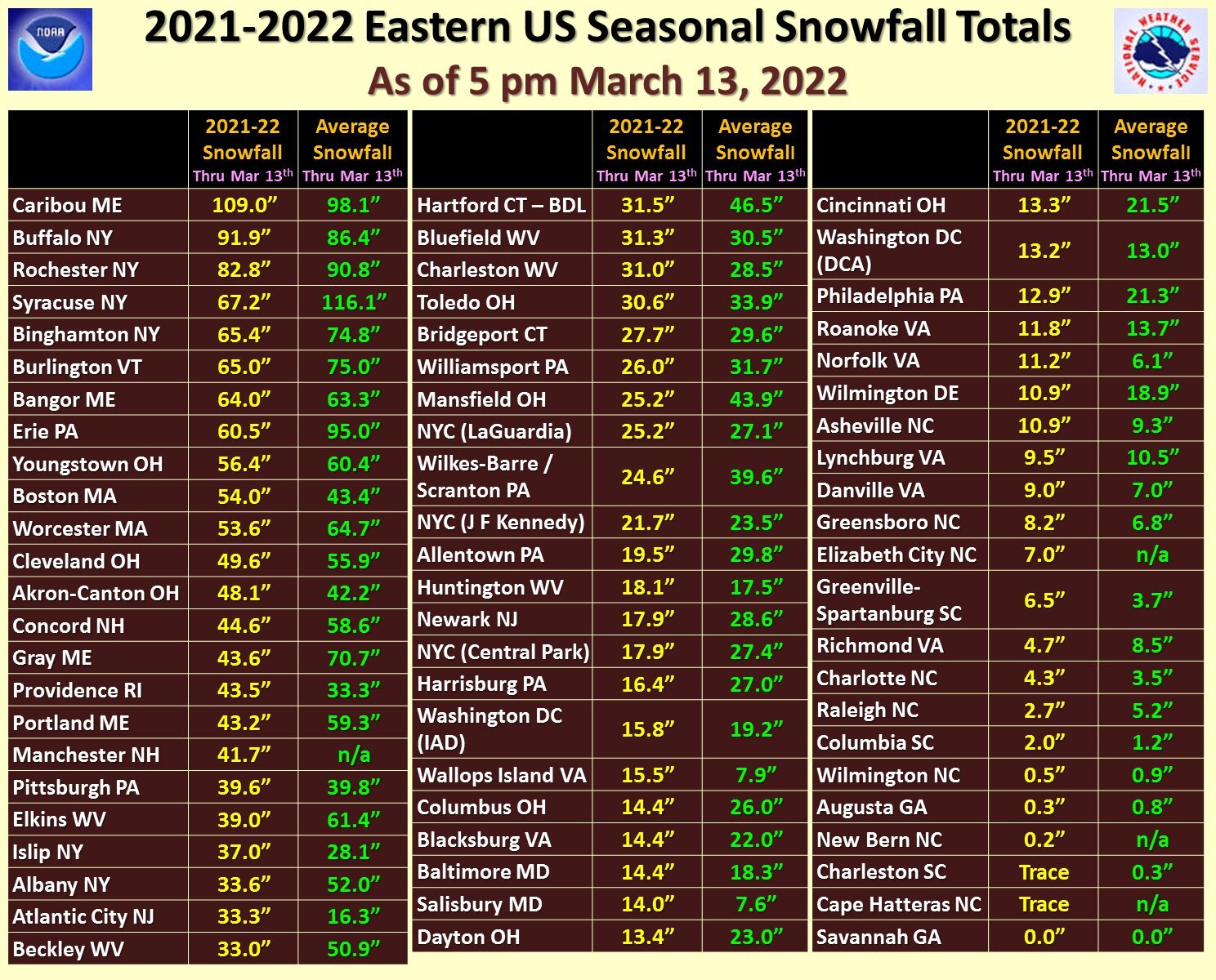
Looking like a good probability of at least a moderate event Saturday. Don’t see this popping >70% 3 days out too often.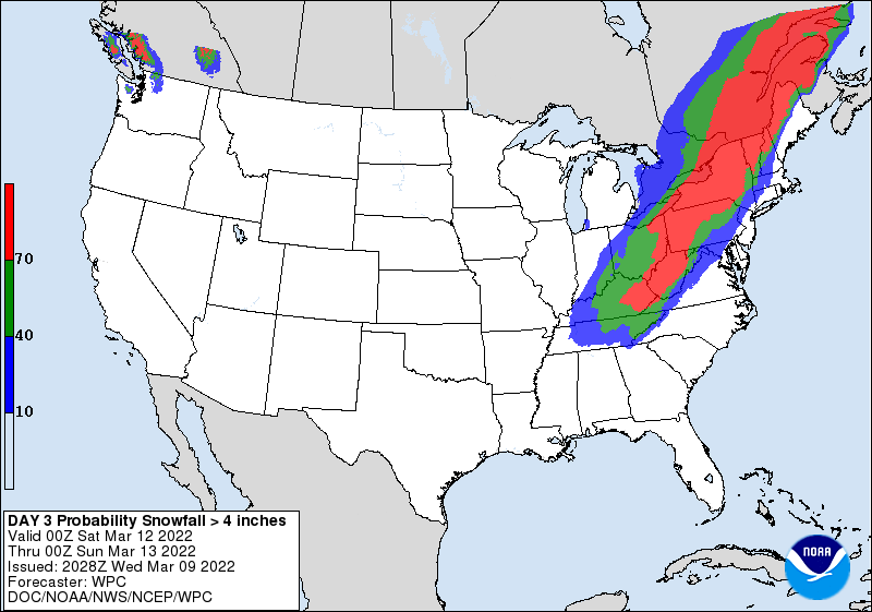
-
Western PA/Pittsburgh Winter 2021/22 Discussion
Burghblizz replied to meatwad's topic in Upstate New York/Pennsylvania
Probably decided against it since the impact to the roads is less than what the snow totals are, AND there wasn’t one from the start. -
The heaviest bands now are stopping at the AGC line. KPITs yard is taking the good stuff!
-
Western PA/Pittsburgh Winter 2021/22 Discussion
Burghblizz replied to meatwad's topic in Upstate New York/Pennsylvania
2.3” at NWS as of 9:30. Could easily hit 4”. Roads are still in generally good shape around here. -
Western PA/Pittsburgh Winter 2021/22 Discussion
Burghblizz replied to meatwad's topic in Upstate New York/Pennsylvania
12Z NAM for Saturday is a cutter…until it isn’t. Stops in its tracks in central WV then makes a right and dumps a foot. Good run for us, although not sure that evolution is realistic. -
It’s snowing aht…
-
Western PA/Pittsburgh Winter 2021/22 Discussion
Burghblizz replied to meatwad's topic in Upstate New York/Pennsylvania
I know this doesn’t hold up as an “official ob”, but 2” on my deck furniture so far