Burghblizz
-
Posts
1,742 -
Joined
-
Last visited
Content Type
Profiles
Blogs
Forums
American Weather
Media Demo
Store
Gallery
Everything posted by Burghblizz
-

Pittsburgh/Western PA WINTER ‘25/‘26
Burghblizz replied to Burghblizz's topic in Upstate New York/Pennsylvania
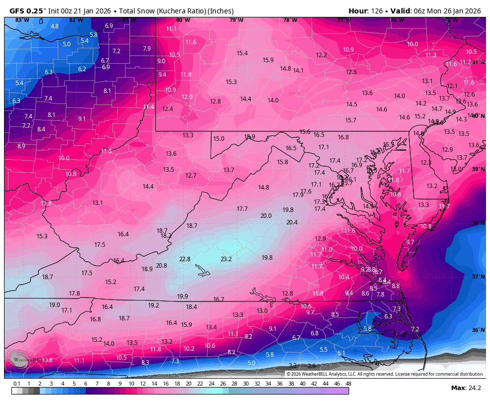
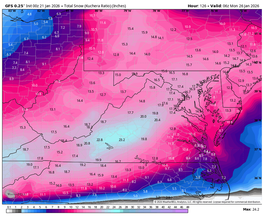
Icon is a mauling. 15”-20” forum wide with tongue back in WV where it belongs. -
Pittsburgh/Western PA WINTER ‘25/‘26
Burghblizz replied to Burghblizz's topic in Upstate New York/Pennsylvania
Of course it also depends on where that guy was. -
Pittsburgh/Western PA WINTER ‘25/‘26
Burghblizz replied to Burghblizz's topic in Upstate New York/Pennsylvania
Who was the one having lunch? I think that was probably an intentional exaggeration to highlight he thought it still might be come NW -
Pittsburgh/Western PA WINTER ‘25/‘26
Burghblizz replied to Burghblizz's topic in Upstate New York/Pennsylvania
I like that it gives close to the same output for most of us, despite a different path than GFS. GFS has 20”+ where Euro has that tongue signature. Would be sweating it more in through there. -
Pittsburgh/Western PA WINTER ‘25/‘26
Burghblizz replied to Burghblizz's topic in Upstate New York/Pennsylvania
Cliff notes on new NWS AFD…. 50/50 shot at >10” in Pgh with higher probability south. -
Pittsburgh/Western PA WINTER ‘25/‘26
Burghblizz replied to Burghblizz's topic in Upstate New York/Pennsylvania
Charleston on that early -
Pittsburgh/Western PA WINTER ‘25/‘26
Burghblizz replied to Burghblizz's topic in Upstate New York/Pennsylvania
Definitely a known bias. And again I have to think the with the majority of the guidance still with plenty of room to the south, I don’t hate it. Let’s smell the sleet and take a swing! -
Pittsburgh/Western PA WINTER ‘25/‘26
Burghblizz replied to Burghblizz's topic in Upstate New York/Pennsylvania
But that’s the warmest of the guidance and still brings double digit snows. Sometimes that solution would be the “one in our camp” knowing that we are going to lose it. -
Pittsburgh/Western PA WINTER ‘25/‘26
Burghblizz replied to Burghblizz's topic in Upstate New York/Pennsylvania
GFS to me looks like not quite the phase, but gets the job done. Might trade some rates for longer duration, but looking like 12+ into SW Pa. -
Pittsburgh/Western PA WINTER ‘25/‘26
Burghblizz replied to Burghblizz's topic in Upstate New York/Pennsylvania
If that happens…and it’s a big if….antecedent cold is more than typical. So I think the results would still be good, even if it ends with some mix. -
Pittsburgh/Western PA WINTER ‘25/‘26
Burghblizz replied to Burghblizz's topic in Upstate New York/Pennsylvania
Euro is Amped! -
Pittsburgh/Western PA WINTER ‘25/‘26
Burghblizz replied to Burghblizz's topic in Upstate New York/Pennsylvania
Honestly, I’d probably throw out the Ukie at this point. Seriously doubt the inland low plows into that high pressure like that. I’m going to continue to root for the others to come north. The GFS was just a correction. It’s not going to continue to jump at that pace given the other guidance out there. We have a lot of wiggle room on the others -
Pittsburgh/Western PA WINTER ‘25/‘26
Burghblizz replied to Burghblizz's topic in Upstate New York/Pennsylvania
If it snows 18”, I won’t care what happens after the last flake falls :-) -
Pittsburgh/Western PA WINTER ‘25/‘26
Burghblizz replied to Burghblizz's topic in Upstate New York/Pennsylvania
I think because we went from the outside looking in to firmly in the game. So it feels like more time for it to get better -
Pittsburgh/Western PA WINTER ‘25/‘26
Burghblizz replied to Burghblizz's topic in Upstate New York/Pennsylvania
Anyone have Ukie Kuchera just for fun. Thats likely way over amped (I doubt it drizzles Sunday). But I bet that’s a nice 15”+ before that. -
Pittsburgh/Western PA WINTER ‘25/‘26
Burghblizz replied to Burghblizz's topic in Upstate New York/Pennsylvania
-
Pittsburgh/Western PA WINTER ‘25/‘26
Burghblizz replied to Burghblizz's topic in Upstate New York/Pennsylvania
Less clown maps in those days. It was a lot of looking at the QPF and assuming. I remember seeing 2.5” or so modeled at one point. -
Pittsburgh/Western PA WINTER ‘25/‘26
Burghblizz replied to Burghblizz's topic in Upstate New York/Pennsylvania
I believe it was over 2”. It wasn’t a high ratio storm -
Pittsburgh/Western PA WINTER ‘25/‘26
Burghblizz replied to Burghblizz's topic in Upstate New York/Pennsylvania
It’s shown that elongated backside a few runs -
Pittsburgh/Western PA WINTER ‘25/‘26
Burghblizz replied to Burghblizz's topic in Upstate New York/Pennsylvania
Gfs a big improvement over 12z. I think the 6” line is back to M/D line in western pa. I think this storm has been talked about so much already, it’s easy to forget it’s still 4+ days out. -
Pittsburgh/Western PA WINTER ‘25/‘26
Burghblizz replied to Burghblizz's topic in Upstate New York/Pennsylvania
Let’s face it. If we’re in the middle of a wide swath of 12+ and it were 5 days out, that would wind up in Toronto. This has to come north. Right? -
Pittsburgh/Western PA WINTER ‘25/‘26
Burghblizz replied to Burghblizz's topic in Upstate New York/Pennsylvania
Several nice bands drifting in from the west -
Pittsburgh/Western PA WINTER ‘25/‘26
Burghblizz replied to Burghblizz's topic in Upstate New York/Pennsylvania
I feel like we got like 1-2” in single digits in December of (I think) ‘22. It was pretty impactful on the roads. -
Pittsburgh/Western PA WINTER ‘25/‘26
Burghblizz replied to Burghblizz's topic in Upstate New York/Pennsylvania
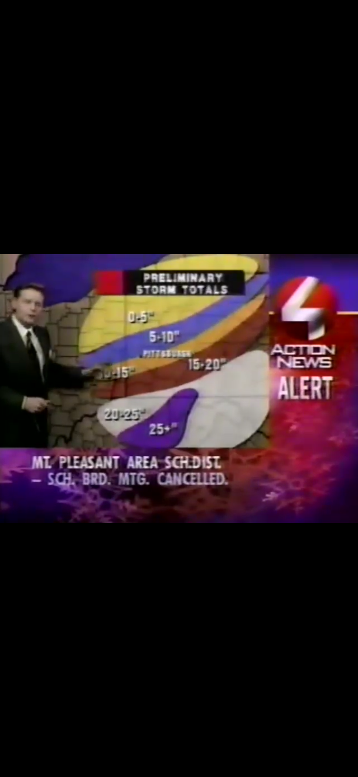
Bit of a crazy gradient here with that storm. I think it was officially 10”, but it ramped up quick south and east. Some places south would have gotten their 3rd 20” storm in less than 3 years (this after a very slow period in the late 80s, early 90s) Mixed feelings on it overall. I lived in Oakland and had a solid foot. But obviously one of the impactful storms ever in terms of the amounts it dumped on highly populated areas. Tough to see others getting 20 and 30”
-
Pittsburgh/Western PA WINTER ‘25/‘26
Burghblizz replied to Burghblizz's topic in Upstate New York/Pennsylvania
Glad we had a good start! Normally, this is where I feel like the days can get away quick. Warm up next week, then suddenly it’s mid January. Good to be sitting on 20”+ as opposed to 4 or 5”.