Burghblizz
-
Posts
1,742 -
Joined
-
Last visited
Content Type
Profiles
Blogs
Forums
American Weather
Media Demo
Store
Gallery
Everything posted by Burghblizz
-

Pittsburgh/Western PA WINTER ‘25/‘26
Burghblizz replied to Burghblizz's topic in Upstate New York/Pennsylvania
I always assume with the point and click that you can’t just add the high numbers together. I think timing is a factor. In other words, if u got 4” in the first part of the period, you may have already taken a few inches from the second. Nonetheless - I’d take that forecast any day! -
Pittsburgh/Western PA WINTER ‘25/‘26
Burghblizz replied to Burghblizz's topic in Upstate New York/Pennsylvania
It’s because it’s all Virga and the radar is catching snow aloft further away from the site (due to the earths curve it’s basically catching the atmosphere higher) I think it fills in as the it gets closer to the ground around the site -
Pittsburgh/Western PA WINTER ‘25/‘26
Burghblizz replied to Burghblizz's topic in Upstate New York/Pennsylvania
I’m not sure I’d worry too much about the 4th or 5th best model knocking an inch or two off. Might be on to something but it’s not like it suddenly changed its solution entirely -
Pittsburgh/Western PA WINTER ‘25/‘26
Burghblizz replied to Burghblizz's topic in Upstate New York/Pennsylvania
It’s also pretty close to what it’s been showing. Don’t understand that comment at all -
Pittsburgh/Western PA WINTER ‘25/‘26
Burghblizz replied to Burghblizz's topic in Upstate New York/Pennsylvania
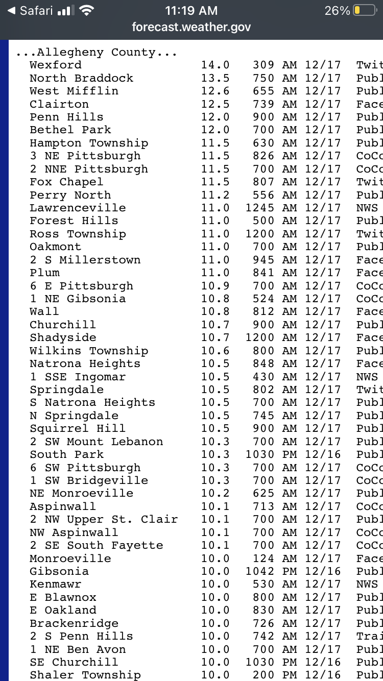
Funny how people quickly forget about this beauty in Dec 2020. Before that it was 11” in 3.2018. So we have a had a couple “foot type” storms since 2010. But that tells me if you want to engrain this in memories, we probably need to be up over a foot officially, with 15” reports around.
-
Pittsburgh/Western PA WINTER ‘25/‘26
Burghblizz replied to Burghblizz's topic in Upstate New York/Pennsylvania
At this point it might not even by overperform - just “perform” -
Pittsburgh/Western PA WINTER ‘25/‘26
Burghblizz replied to Burghblizz's topic in Upstate New York/Pennsylvania
I like the timing of this. Since it will (hopefully) be all day tomorrow, I don’t feel obligated to stay up. Up early and let’s get it on -
Pittsburgh/Western PA WINTER ‘25/‘26
Burghblizz replied to Burghblizz's topic in Upstate New York/Pennsylvania
McCarthy…. -
Pittsburgh/Western PA WINTER ‘25/‘26
Burghblizz replied to Burghblizz's topic in Upstate New York/Pennsylvania
The were looking at Pivotal 10:1, so could have been other presentations that showed more snow. -
Pittsburgh/Western PA WINTER ‘25/‘26
Burghblizz replied to Burghblizz's topic in Upstate New York/Pennsylvania
Keep in mind Euro is historically a warmer model that also has called off many a storm. If you blend all the other guidance, this result seems pretty feasible. And it’s not on the super warm train. (Maybe not quite the totals, but the general depiction in our area seems good) -
Pittsburgh/Western PA WINTER ‘25/‘26
Burghblizz replied to Burghblizz's topic in Upstate New York/Pennsylvania
I doubt think that NAM result guarantees anything down the road - but it certainly shows it can overdo it. Still optimistic that city and points north stay clean. Honestly, the only area in the metro area where things might be held down to a significant degree is the 119 cooridoor. But hopefully still >8” in through there before mixing. -
Pittsburgh/Western PA WINTER ‘25/‘26
Burghblizz replied to Burghblizz's topic in Upstate New York/Pennsylvania
“Reliable source” -
Pittsburgh/Western PA WINTER ‘25/‘26
Burghblizz replied to Burghblizz's topic in Upstate New York/Pennsylvania
I think the main thing at this point that will determine 10” versus 15” for Allegheny County is ratios. Everything else looks locked and loaded! -
Pittsburgh/Western PA WINTER ‘25/‘26
Burghblizz replied to Burghblizz's topic in Upstate New York/Pennsylvania
Forget what I said about not putting too much stock in the rapid refresh models out to 48… -
Pittsburgh/Western PA WINTER ‘25/‘26
Burghblizz replied to Burghblizz's topic in Upstate New York/Pennsylvania
Chat GTP basically told me it’s “typical NAM behavior” and that it holds on to partially melted particles even if the warm layer was very shallow or gone. Disclaimer: I’m posting this snippet for entertainment purposes, and we know that the NAM does in many cases sniff this out. But could be something to this: Ignore NAM sleet if: 850–700 mb is ≤ –2°C No >0°C layer ≥ ~30 mb Other models (GFS is snow Use NAM for: QPF placement Thermal trends Frontogenesis / banding signals But not for dominant p-type in marginal cold events. -
Pittsburgh/Western PA WINTER ‘25/‘26
Burghblizz replied to Burghblizz's topic in Upstate New York/Pennsylvania
Tongue closed in on 3k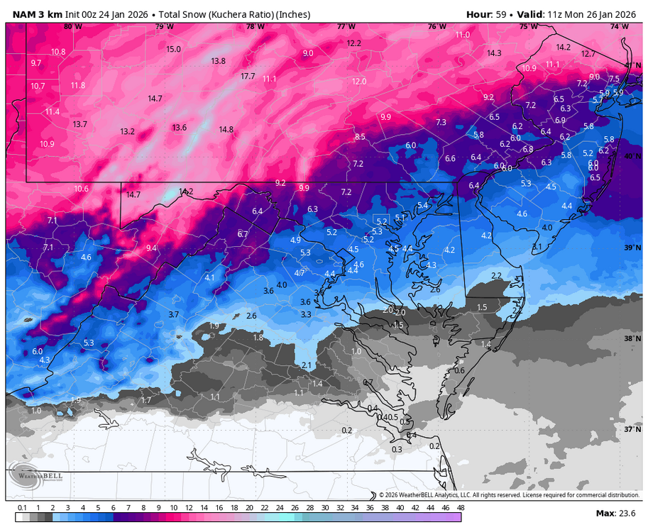
-
Pittsburgh/Western PA WINTER ‘25/‘26
Burghblizz replied to Burghblizz's topic in Upstate New York/Pennsylvania
Yeah as far as the overall area, it probably would have wound up averaging around 15” for the entire storm. I do think it’s overdoing that tongue for the southerners. Those rapid refreshes tend to drag more warm air in, and the longer ranges loses the short term data assimilation that anchors it. -
Central PA Winter 25/26 Discussion and Obs
Burghblizz replied to MAG5035's topic in Upstate New York/Pennsylvania
That’s only through 5 PM Sunday -
Pittsburgh/Western PA WINTER ‘25/‘26
Burghblizz replied to Burghblizz's topic in Upstate New York/Pennsylvania
I think NWS has mentioned it to the south since there is a chance of both wetter snow and ice -
Pittsburgh/Western PA WINTER ‘25/‘26
Burghblizz replied to Burghblizz's topic in Upstate New York/Pennsylvania
That’s a good sign if higher res is showing less of the garbage -
Pittsburgh/Western PA WINTER ‘25/‘26
Burghblizz replied to Burghblizz's topic in Upstate New York/Pennsylvania
We’ll see if it holds on to this at 0Z. I wish for the southern guys it pulled back a little on the tongue - but I still think everyone is fine given it’s about the most north guidance there is. Totals should still look pretty NAMMY for most. -
Pittsburgh/Western PA WINTER ‘25/‘26
Burghblizz replied to Burghblizz's topic in Upstate New York/Pennsylvania
Yeah I said that in a follow up. It’s Z -
Pittsburgh/Western PA WINTER ‘25/‘26
Burghblizz replied to Burghblizz's topic in Upstate New York/Pennsylvania
You are right about that - it’s actually 10 PM Sunday. Same idea though - would be nice to get that kind of icing on the cake late in the storm. -
Pittsburgh/Western PA WINTER ‘25/‘26
Burghblizz replied to Burghblizz's topic in Upstate New York/Pennsylvania
What’s interesting is that is actually early Monday morning. Doubt that exact thing happens - but directionally the GFS is saying that if we get the prolonged back end, there could be some high ratio snows. -
Pittsburgh/Western PA WINTER ‘25/‘26
Burghblizz replied to Burghblizz's topic in Upstate New York/Pennsylvania
5:1 ratios in the low teens would be something. Probably tiny flakes