Burghblizz
-
Posts
1,742 -
Joined
-
Last visited
Content Type
Profiles
Blogs
Forums
American Weather
Media Demo
Store
Gallery
Everything posted by Burghblizz
-

Pittsburgh/Western PA WINTER ‘25/‘26
Burghblizz replied to Burghblizz's topic in Upstate New York/Pennsylvania
Don’t see this too often:
-
Pittsburgh/Western PA WINTER ‘25/‘26
Burghblizz replied to Burghblizz's topic in Upstate New York/Pennsylvania
Some good summaries on this page https://www.weather.gov/media/pbz/DssPacket.pdf -
Pittsburgh/Western PA WINTER ‘25/‘26
Burghblizz replied to Burghblizz's topic in Upstate New York/Pennsylvania
It’s kind of a shame the locals aren’t really part of this experience any more. Maybe it’s because there is less reliance there….but also no one really jumps out as someone that caters to enthusiasts. For example - KDKA seems like they have a fun met room, but no one is breaking down models and scenarios. Although Ray P did have a bit of a funny X post. Basically said “my forecast is 6-12”. It’s conservative due to a few wild cards, and will probably go up…but don’t ask me about someone else’s forecast. Ask them!”. Obviously he is likely getting bombarded with questions since weather apps had been flashing big numbers for days. -
Central PA Winter 25/26 Discussion and Obs
Burghblizz replied to MAG5035's topic in Upstate New York/Pennsylvania
Really like that presentation. -
Pittsburgh/Western PA WINTER ‘25/‘26
Burghblizz replied to Burghblizz's topic in Upstate New York/Pennsylvania
GFS tellin yinz to chill -
Pittsburgh/Western PA WINTER ‘25/‘26
Burghblizz replied to Burghblizz's topic in Upstate New York/Pennsylvania
I think it’s a potential replacement for HRRR/RAP and those tend to compound thermal errors outside of 18 hours. -
Pittsburgh/Western PA WINTER ‘25/‘26
Burghblizz replied to Burghblizz's topic in Upstate New York/Pennsylvania
Isn’t that like a next gen rapid refresh model? I would think that would have a warm bias in this range. -
Pittsburgh/Western PA WINTER ‘25/‘26
Burghblizz replied to Burghblizz's topic in Upstate New York/Pennsylvania
Where were they at? -
Pittsburgh/Western PA WINTER ‘25/‘26
Burghblizz replied to Burghblizz's topic in Upstate New York/Pennsylvania
That freezing rain looks like it has evil eyes -
Pittsburgh/Western PA WINTER ‘25/‘26
Burghblizz replied to Burghblizz's topic in Upstate New York/Pennsylvania
Maybe a smidge drier overall, but certainly nothing that leaps towards the NAM. 0Z may be interesting as it corrected (in a good way) north yesterday. But obviously a wide sweet spot still -
Pittsburgh/Western PA WINTER ‘25/‘26
Burghblizz replied to Burghblizz's topic in Upstate New York/Pennsylvania
GFS is gonna hold -
Pittsburgh/Western PA WINTER ‘25/‘26
Burghblizz replied to Burghblizz's topic in Upstate New York/Pennsylvania
Germans hold at 18z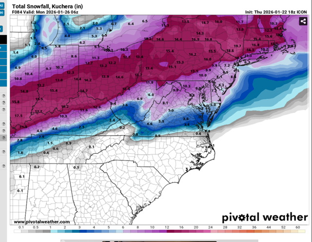
-
Pittsburgh/Western PA WINTER ‘25/‘26
Burghblizz replied to Burghblizz's topic in Upstate New York/Pennsylvania
Evolution of the NAM looks fine. Can’t really put too much stock in what it does in the final 24 hours. Really plows the SLP north and dry slots us a bit. Heavier snows would be city and north -
Pittsburgh/Western PA WINTER ‘25/‘26
Burghblizz replied to Burghblizz's topic in Upstate New York/Pennsylvania
This doesn’t make a whole lot of sense to me, unless they really think ratios would be impacted. Most of the immediate area would still see no ice, but they would be scaling back accum everywhere. But I also have to think this is the heaviest QPF scenario. -
Pittsburgh/Western PA WINTER ‘25/‘26
Burghblizz replied to Burghblizz's topic in Upstate New York/Pennsylvania
Euro flirts a little more with the tongue than GFS, and doesn’t quite have that long duration that goes into Monday. But it gets close as far as output and or probably thumps a little harder along the way. -
Pittsburgh/Western PA WINTER ‘25/‘26
Burghblizz replied to Burghblizz's topic in Upstate New York/Pennsylvania
Not gonna lie - I went looking for the high end potential version, but didn’t see it yet. -
Pittsburgh/Western PA WINTER ‘25/‘26
Burghblizz replied to Burghblizz's topic in Upstate New York/Pennsylvania
I’d be a little disappointed if it’s 6 or 7, although I know that’s a reasonable “good” outcome still. Mostly because we have been doing well with beefed up clippers and LES producing 4-6” type snows. Definitely a different investment in this one! -
Pittsburgh/Western PA WINTER ‘25/‘26
Burghblizz replied to Burghblizz's topic in Upstate New York/Pennsylvania
I doubt we get there even in the win scenario. I think the official 10th biggest is around 15” or 16”. While the official total tends to be on the higher side when it comes to seasonal totals, it’s usually on the lower side with major storms. Storms like Jan ‘94 and Jan ‘96 are nowhere to be found, even though parts of AGC/Wash/Westmoreland got 20”+. I don’t think that’s what we are looking at here, but man it would be nice. -
Central PA Winter 25/26 Discussion and Obs
Burghblizz replied to MAG5035's topic in Upstate New York/Pennsylvania
It has…and it does. But usually in the panels inside 48 hours. -
Pittsburgh/Western PA WINTER ‘25/‘26
Burghblizz replied to Burghblizz's topic in Upstate New York/Pennsylvania
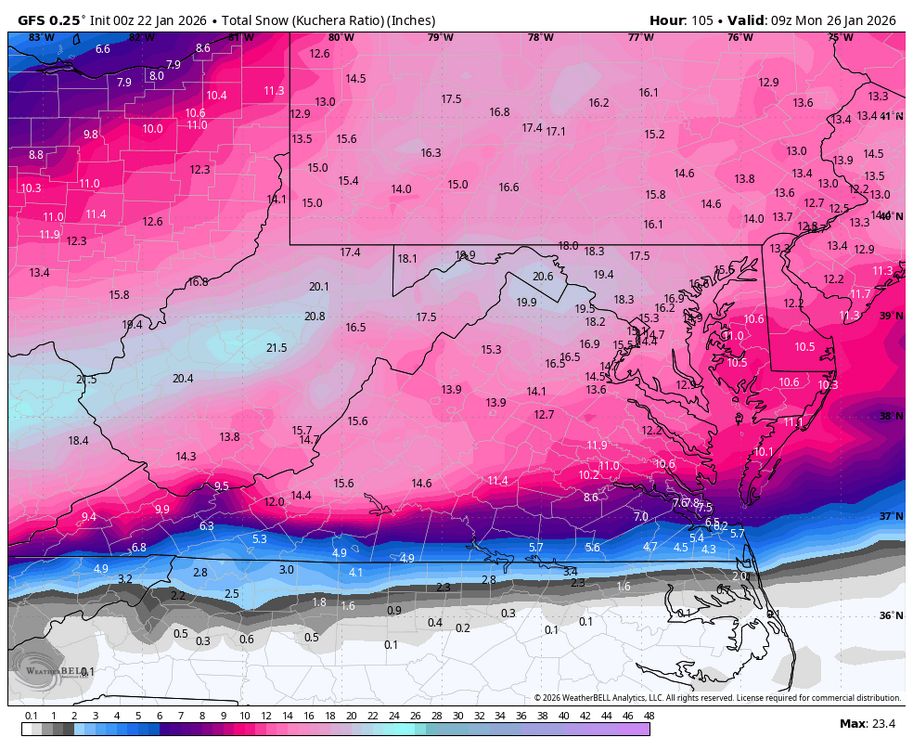
The only thing NAM did was not give the warm and fuzzies of passing around 20” Kuchera maps. Don’t think it changes much at this point. -
Pittsburgh/Western PA WINTER ‘25/‘26
Burghblizz replied to Burghblizz's topic in Upstate New York/Pennsylvania
It was looking stringy and unorganized at first, but it’s getting its act together by hour 72. The end result will be good. Taken literally, it suppresses the precip at first, and then drives the SLP into our backyard which creates mix and dry slot issues. I guess it’s an example of threading the needle to get a “fail” for bigger snows, but verbatim still probably 10” + -
Pittsburgh/Western PA WINTER ‘25/‘26
Burghblizz replied to Burghblizz's topic in Upstate New York/Pennsylvania
lol - rage bait. Yeah, I had to do a double take at the timeframe. I really do think though it’s because they don’t want to put out a map that extends more than 72 hours out. -
Pittsburgh/Western PA WINTER ‘25/‘26
Burghblizz replied to Burghblizz's topic in Upstate New York/Pennsylvania
Good info and good balanced take. I’ll still look at the clown maps and dream, but great info for what is more likely (which isn’t bad at all) -
Pittsburgh/Western PA WINTER ‘25/‘26
Burghblizz replied to Burghblizz's topic in Upstate New York/Pennsylvania
I’d say the 6Zs more than held serve! -
Pittsburgh/Western PA WINTER ‘25/‘26
Burghblizz replied to Burghblizz's topic in Upstate New York/Pennsylvania