

jaxjagman
-
Posts
8,302 -
Joined
-
Last visited
Content Type
Profiles
Blogs
Forums
American Weather
Media Demo
Store
Gallery
Posts posted by jaxjagman
-
-
8 minutes ago, Itryatgolf70 said:
Okay. I thought they came out every day now. My apologies
Mondays and Thursday,no need to apologize
-
 2
2
-
-
2 hours ago, Itryatgolf70 said:
Anybody have the euro weeklies from today? Didn't see it posted.
Maybe because its still Sunday

-
1
-
-
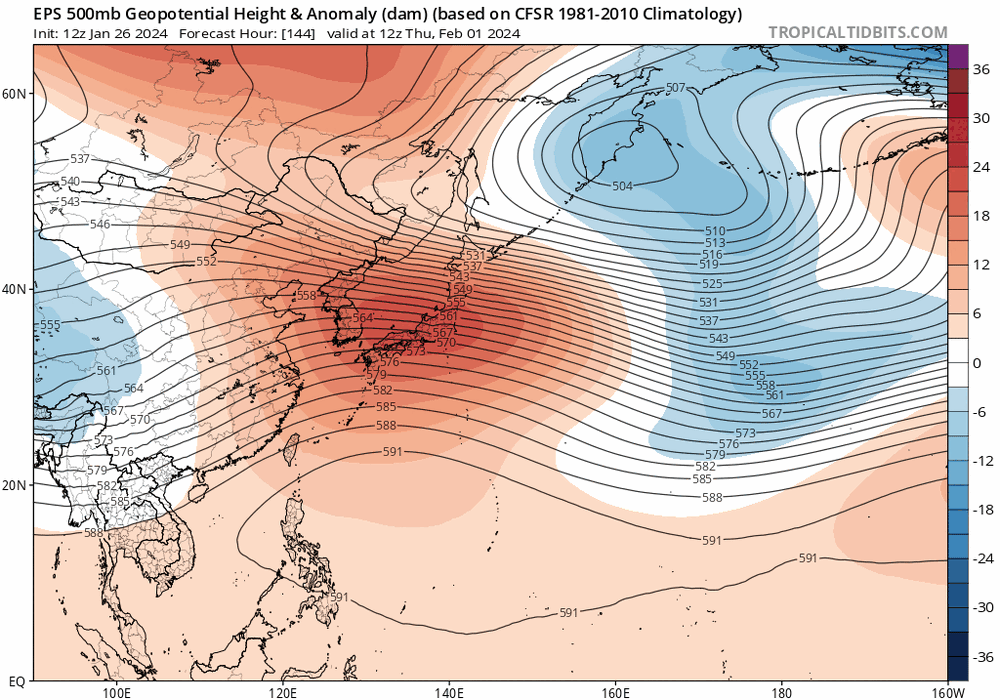
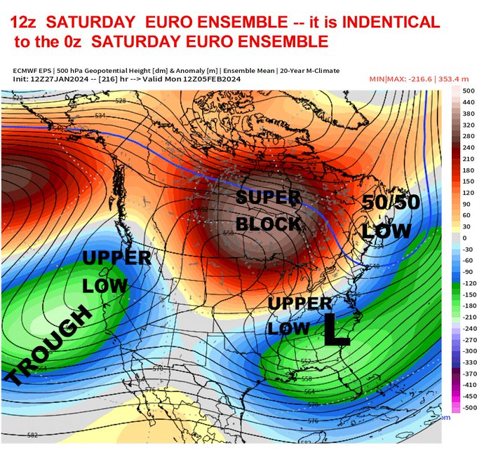
This is actually pretty nice the GEFS and EPS are on the same page,you can look at Carvers map above and the pattern should be something similar to his maps around mid Feb
.thumb.png.a7c98d995f1a85bb39bae6762138e2db.png)
-
1
-
-
Quite a few more members today showing the MJO into the WH as we are into Feb.Mean doesnt seem to have a whole lot of support
.png.5f134e2b6f68715e7e77ab8b262aeb6a.png)
-
4
-
-
It still amazes me how the pattern looks so similar to 2021.I had to rub my eyes,check it over and over and over to make sure i had the right dates,even the MJO into the IO almost did the same thing into Jan around the same exact time frame
-
2
-
-
21 minutes ago, Carvers Gap said:
The 12z GEPS now looks like the EPS ext from yesterday....The GEPS gets there about 24 hours quicker. Either way, this is what we mean when we begin to see Weeklies and global ensembles in sync. Pretty good agreement between two different models.
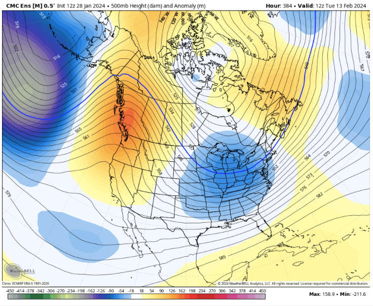
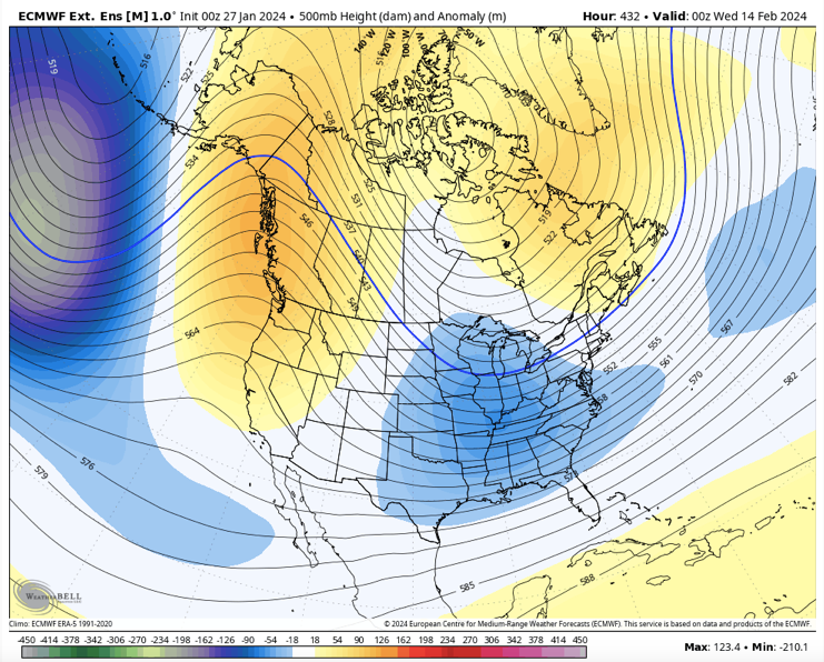
Certainly as of today someone could get a winter storm towards the mid month of Feb in our parts if the teles work in our favor
-
4
-
-
2 minutes ago, Carvers Gap said:
The 12z GEPS now looks like the EPS ext from yesterday....The GEPS gets there about 24 hours quicker. Either way, this is what we mean when we begin to see Weeklies and global ensembles in sync. Pretty good agreement between two different models.
This would be similar to what the GFS is showing with a warm up in East Asia which should possibly be into the 2nd week of Feb, for us then the heights fall
-
2
-
-
Then go ahead into mid March you can see what actually transpired in 2021,not saying this will happen again,just pointing stuff from 2021 vs 2024
.thumb.png.4c0e7bf76d39186de14164e6d88bb30d.png)
-
2
-
-
Here is the velocity comparing 2021 vs 2024,1st map is 2021
.thumb.png.8e6bc9865e7fe42e3a49bb703f2897e1.png)
.thumb.png.05e394bc1f761f5347ebc129ccb9724c.png)
-
3
-
 1
1
-
-
Here is the MJO back into 2021 compared to this year,the stopping point is Feb 18th.We had a major winter storm Feb14-15 in Middle Tn.See and similarity?
.thumb.png.681214cb6b734c37a57888d6023bf732.png)
.png.88d33c0a4fb408b411b1511e25ac00b6.png)
-
3
-
-
58 minutes ago, Daniel Boone said:
Aa far as believing, not that I do but, no different than believing 70 degrees that far out or posting something regarding a mild rainstorm. Are you criticising any of that ? As far as DT, I'm not a fan of him personally ( attitude problem) but, he is still overall a good Meteorologist.
Meh,lets let it go,i shouldnt have said anything myself .
-
1
-
-
3 hours ago, Daniel Boone said:
He's obviously buying the Euro Solution. Feb. 5-6 is timeframe he listed.
I reckon,good luck to him 9-10 days out

-
1 minute ago, jaxjagman said:
He cant be serious,its going OTS
The whole patterm looks nothing more than a meridonal flow into Feb
-
19 minutes ago, Daniel Boone said:
INCREASING THREAT FOR MAJOR WINTER STORM FOR TENN VALLEY AND MID ATLANTIC FEB 4-5
He cant be serious,its going OTS
-
1
-
-
1 minute ago, jaxjagman said:
Seems like the models are trending slower today,what was looking like like height rises around the 9th and 10th look to be getting pushed back to more the 11th or 12th or around there,seems like any cool down will be around the 17th now give or take thats just my take right now
Actually the more i look at this map i'm gonna still say mid month still
-
Seems like the models are trending slower today,what was looking like like height rises around the 9th and 10th look to be getting pushed back to more the 11th or 12th or around there,seems like any cool down will be around the 17th now give or take thats just my take right now
-
Seems like the MJO keeps getting pushed back each day into the WP,There is still considerable spread
.thumb.png.33ca60633bdea38d5953c24a233fb470.png)
-
1 hour ago, John1122 said:
The Euro just had a great pass in what would likely be a nice winter storm here. I refuse to believe that a low dropping from 997 to 991 as it skirts the northern gulf coast from Louisiana over the panhandle of Florida would be precip free here.
It's bombogenesis once it hits the gulf stream.Surprised it didnt go OTS
-
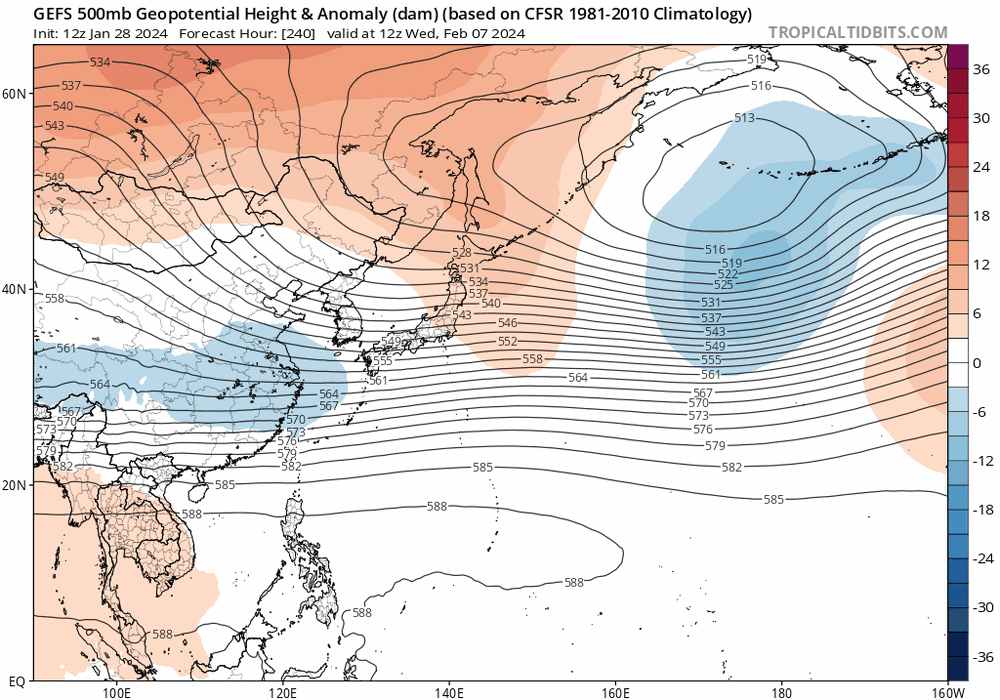
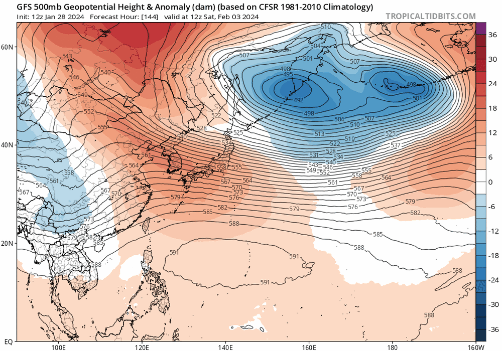
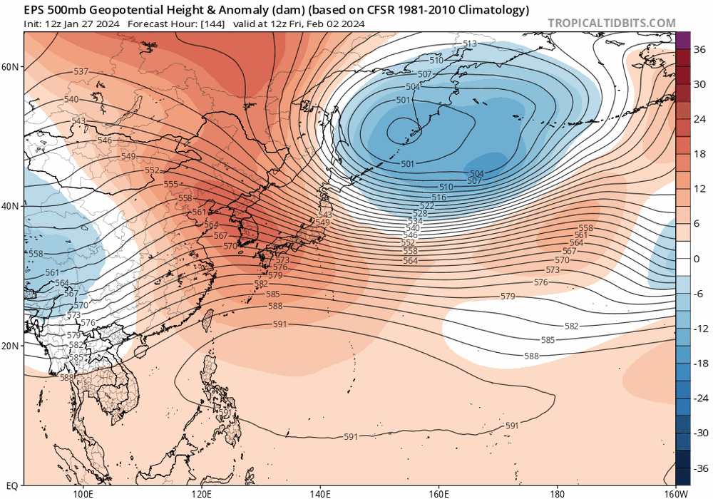
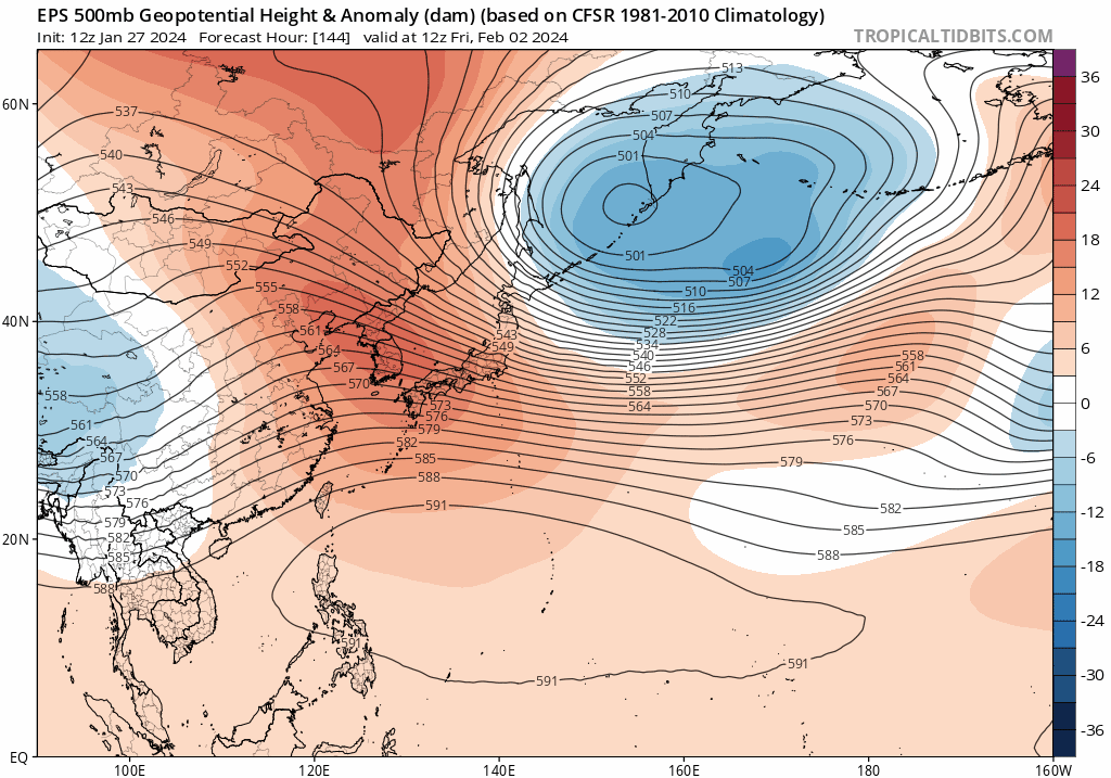
I still think what Carver has been saying is close ,the heights the EPS is showing fall into East China and Korea as we get into Feb is a cold sign for us here,sometimes the jet extension can stay in East Asia despite,still some concern where the MJO will be at and where it actually goes
-
4
-
-
I still wonder where the MJO will be at,it retracts back into Asia but get enhanced once again,could be where its doing all its things into ph7
.thumb.gif.259eb4f95c5a9ed8f6c2200d7b59b13e.gif)
-
4
-
-
Lots more ensembles joined in today for the NH party,just dont like the mean going into the COD,it wouldnt be a game breaker but still
.png.109d9a5dd1b77029aecadf635267ce3b.png)
-
1
-
1
-
-
-
Euro MJO seems to go bonkers into the WP because its been showing another WWB as we get into Feb,its been holding on to keeping the MJO into the WP for a extended stay and hasnt backed down much of any.CFS has been showing the same thing on the velocity but its also been showing a suppressed MJO signal with the 2nd WWB and the MJO is more advanced headed towards Africa and the Western IO into wk2 of Feb today
.thumb.png.d3452a68676b4dc76ae35b3f2c8d8a23.png)
.thumb.png.79b8b1efe7368db550ee553a174877f4.png)
.thumb.png.90d4e947bb7a31b525d29443808850f1.png)
-
3
-
1
-
-
I'm not saying this will happen or will be politically correct,but the pattern does have some resemblence to Feb 2021.Once again this is not a forecast
")
Overview
An Arctic airmass spread across Middle Tennessee from Thursday February 11 through Sunday February 14, 2021, bringing very cold temperatures in the teens and 20s along with lengthy periods of freezing drizzle. This led to ice forming on elevated surfaces such as trees and power lines, as well as bridges, overpasses, and some roadways. As a major winter storm brought additional freezing rain, sleet, and snow to the area from Sunday evening February 14 into Monday February 15, 2021, the previous ice combined with the new ice, sleet, and snow to cause significant ice storm damage across parts of east-central Middle Tennessee, as well as create massive travel disruptions areawide. Locations from Giles and Lincoln Counties northeastward to Pickett and northern Fentress Counties received anywhere from 0.5" to over 1" of ice accretion from the combination of the weekend freezing drizzle plus new freezing rain. Numerous trees and power lines were downed in many counties, resulting in tens of thousands of power outages, with the worst damage affecting Lincoln, Bedford, Coffee, Cannon, Putnam, Overton, and northern Fentress Counties. Elsewhere, 2 to 3 inches of combined sleet and snow along with the frigid temperatures caked most surfaces in a thick layer of ice, with travel coming to a standstill across the northwestern half of Middle Tennessee - including the Nashville metro area.
https://www.worldclimateservice.com/2021/01/22/mjo-forecast-and-stratospheric-warming/
-
3
-
.png.44a7003fb26758f83150b0579e17cc62.png)

.png.111254fcbf1b2660daf29e2375d1dca3.png)
.png.a3689558a79b66a82759d2baf79031ba.png)
.png.512dfaa49a64a237f9fcd242a29dd93b.png)
.png.2263544abe4bdf91eeabf9ddfcd1a804.png)
.png.53af0ebd53f391497e765ae5756baeee.png)


.gif.cbb50d0b6e5132a030f8cb71cfc1b600.gif)

.png.672877b677a736cdc62188e4a77d7b90.png)
.png.e1087828776d9a7fef9f2b9f0c6162ba.png)
.png.2fd6a0a00bd79aa918e81492eda4db4a.png)
February 2024 mid/ long range
in Tennessee Valley
Posted
Yeah and the WWB by the Mean takes it back into the WP for a brief time,starting to have my doubts it gets cold around the mid month,not real cold anyways