

jaxjagman
-
Posts
8,302 -
Joined
-
Last visited
Content Type
Profiles
Blogs
Forums
American Weather
Media Demo
Store
Gallery
Posts posted by jaxjagman
-
-
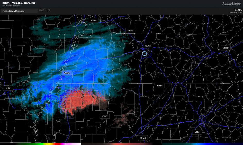
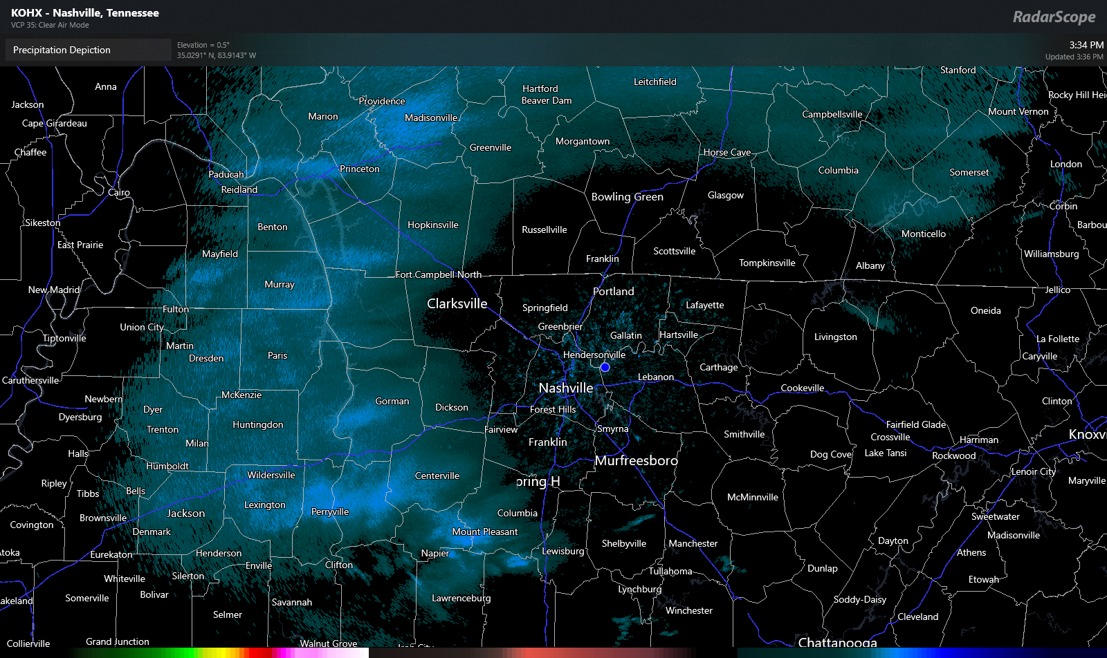
getting a 30-35 dbz band right now,its picked up some
https://g1.ipcamlive.com/player/player.php?alias=brentwood201173a
-
 8
8
-
 1
1
-
-
1 minute ago, BNAwx said:
Right at 2 inches here in Hermitage. Gonna be a fun night!
Radar looks good just to our west25-30dbz should be here soon if it holds
-
8
-
-
4 minutes ago, TellicoWx said:
If you would have asked me 3 hrs ago if I could get to 32 without wetbulbing, I would have said not a shot...yet here we are. T32...DP 26
There seems to have been some weak ridge into your parts holding back on the thermals.i just noticed that on SPC,its shifted into NC now
-
1
-
-
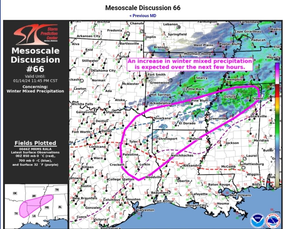
West Tn looks really juicy compared to Mid right now
-
6
-
-
-
Been mostly steady here the last hr or so,plow the came trough and cleared the lane heading towards Franklin,Tn
not sure why my link dont work now

-
3
-
-
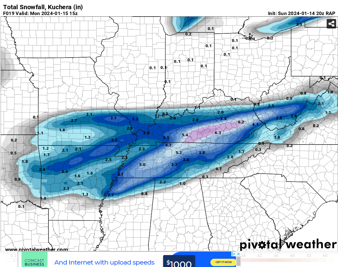
National Weather Service Nashville TN
812 PM CST Sun Jan 14 2024

...New UPDATE...

.UPDATE...
Issued at 755 PM CST Sun Jan 14 2024

It`s snowing!!! All of our observation sites are reporting snow
this hour with the heaviest falling along and south of I-40. We`ve
already received a report of 0.5" of snow in Bellevue. Looking at
the latest run of the HRRR tonight, boy did it come in hot. It
paints a narrow band of higher totals ranging from 6-8 inches from
Wayne County all the way through to our furthest NE counties on
the Plateau, including Nashville. This solution would mean this
event overachieves a little further north than originally
forecasted and it pumps out more snow in any heavier bands that
move through. This will be something to watch as the night
progresses. There were talks of bumping up QPF along our northern
border to match up with this latest run of the HRRR, but for now,
we`re going to hold off on that to see what the next round of
models show since this is only 1 run. Our sounding tonight shows a
textbook snow event; big, healthy layer of moisture right in the
snow growth region with all layers below 0 degrees Celsius. As for
temperatures, they have tanked. Most everyone is sitting right
around 20 degrees and dropping. We will be back with a full
forecast update in the next several hours. In the meantime, stay
safe, stay warm, and enjoy the snow!
-
6
-
-
Might have a inch now its picked up some the last few min
-
3
-
 1
1
-
-
1 minute ago, Matthew70 said:
And they claimed on the game a bit ago it was a record for streaming the game last night. Well I was not one of them streaming it. I will not pay peacock to watch. Greed in college & NFL is ruining a great sport.
Thats bull shit,of course they did to cover there ass and the NFL to do this.Next year you might be doing the SB as PPV,bunch of greedy ass owners
-
1
-
-
5 minutes ago, TellicoWx said:
Not sure if anyone posted...2 hrs ago from SPC...show has really got rolling yet.
by the looks of my radar Memphis should at least have moderate snow right now
-
1
-
-
we are fixing to get one of those bands Chinook posted above any min by the looks
https://g1.ipcamlive.com/player/player.php?alias=brentwood201173a
-
4
-
-
2 minutes ago, Silas Lang said:
It's legitimately insane to me that tomorrow afternoon, nearly the whole state is still covered in snow on radar. It has been a long time since we have had a long duration event.

Its very rare to snow across all of us
-
5
-
-
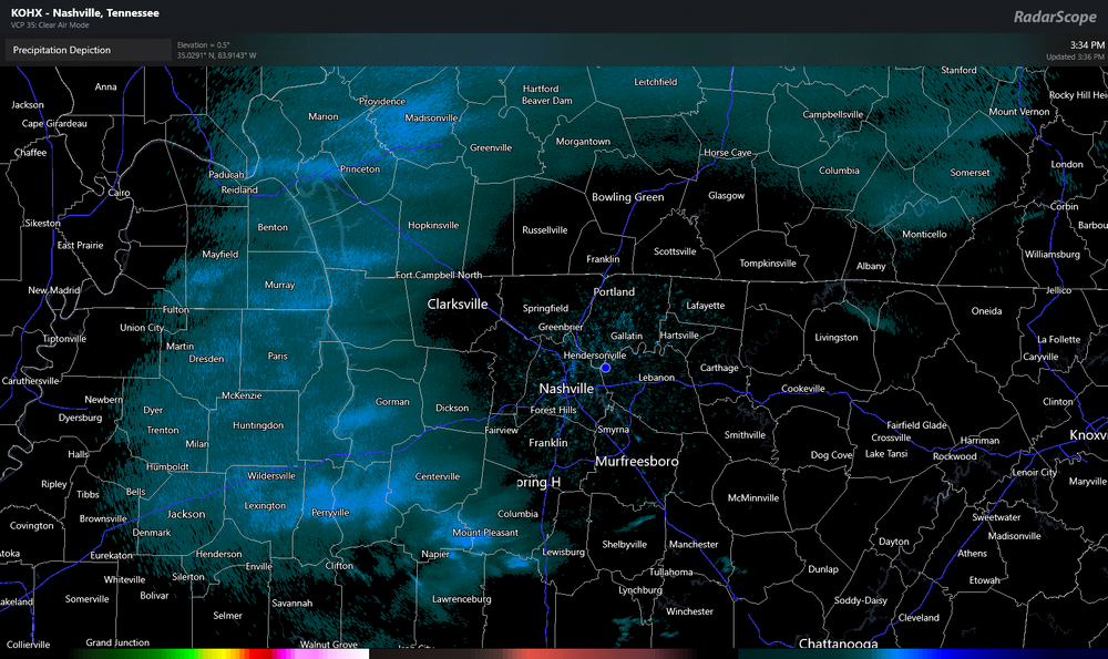
It snowing pretty decent around Memphis it seems,Alabama line,anyone that way?
-
6
-
-
7 minutes ago, nrgjeff said:
Last visit and post for the night. @Chattownsnow and @Uncle Nasty I think the chart above from @TellicoWx eases the Chattanooga anxiety a little bit. We should be able to avoid a Dallas Cowboys style melt-down.
I'll feel better when I see snow falling. Warm air is hanging tough in KCHA but we're always the last to cool off. Already snowing in Knoxville. LOL Chatty. Back to the game!Got pissed off they started charging to watch the playoffs,so i joined the boycott to not watch,plus the Jaguars melt down was easier for me to do this

-
3
-
-
i never understood why people put the flashers on sometimes,its just light snow,i see you.Just a dusting here,heavy stuff is down towards the state line right now
https://g1.ipcamlive.com/player/player.php?alias=brentwood201173a
-
1
-
 1
1
-
-
3 minutes ago, Shocker0 said:
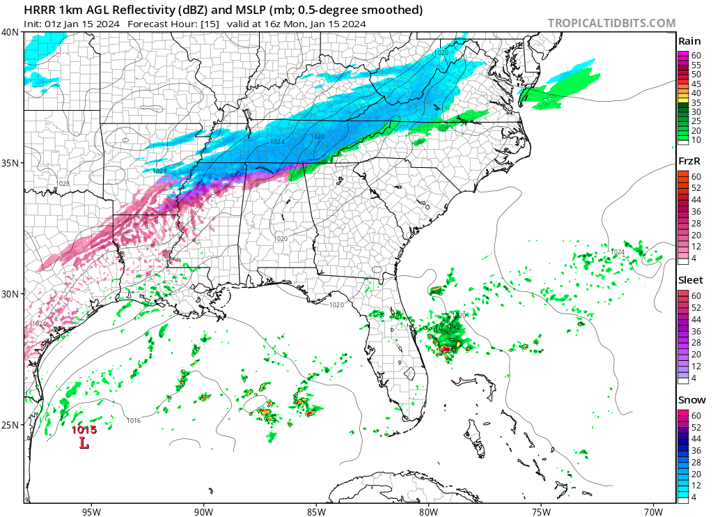
The "Rufus" model moves the heaviest snow well up into Kentucky
at least Kuchera ratios.
Believe that is more the first wave isnt it?
-
3 minutes ago, Carvers Gap said:
Yeah, it does. Chattanooga is in the mix as well.
That was a good run that time
.png.65187d978682eee23e4240c818640d28.png)
-
2
-
-
5 minutes ago, Olhausen said:
You think the globals are going to be way off with this one? Short range models have been showing way higher totals to the north pretty much every run since this system got within their range.
Everyone has their choice but i think the mesoscales work better in this time frame,i dont even look at the globals no more outside 24hrs but everything is guidance to a certain extent
-
1
-
-
getting close
-
6
-
1
-
-
1 minute ago, Matthew70 said:
Murfreesboro is sitting at 30 degrees. A few degrees warmer than forecast.
We are ok,think we should start seeing some snow maybe in a hr.radar seems to be showing this right now for here,your temps shouldnt rise any
-
2
-
-
that should still be pretty disturbing what the RAP is showing last run

-
1
-
-
Just now, PowellVolz said:

.Wow,i was wondering if it was snowing didnt get a chance to look at OBS now i know
-
5
-
-
1 minute ago, Carvers Gap said:
The RAP over the eastern valley is usually pretty poor, but we'll see. A system trending northwest is not out of the question at the last minute. OTH, the RAP and NAM being over amped is also not out of the question at this range.
I still dunno,we usually have warn air in place here and start as more of a mix.Its really rare in our parts to already have cold air in place during a winter storm,so theres not gonna be much data incorporated to me than other skill
-
1
-
-
9 minutes ago, Carvers Gap said:
The 18z NAM again looks like it is experiencing feed back issues. And that is a bias of it. It turns the line of precip well north and much earlier over the eastern valley. It could score a coup and certainly has before, but big totals(which aren't on other models) are usually indicative of feedback. We'll see.
I dunno,the RAP just did the same
-
1
-


January 15th-17th 2024 Arctic Blast/Snow Event
in Tennessee Valley
Posted
Yeah yall should be getting what we are soon,moderate snow here now