

jaxjagman
-
Posts
8,302 -
Joined
-
Last visited
Content Type
Profiles
Blogs
Forums
American Weather
Media Demo
Store
Gallery
Posts posted by jaxjagman
-
-
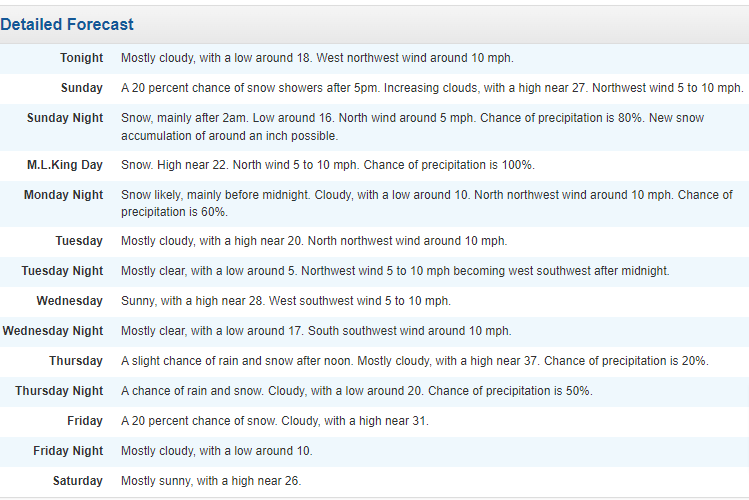
National Weather Service Nashville TN
138 PM CST Sun Jan 14 2024

...New SHORT TERM, LONG TERM...

.SHORT TERM...
(This afternoon through Monday Night)
Issued at 130 PM CST Sun Jan 14 2024

No major changes will be made to the forecast for the very cold
and snowy weather coming our way. A Winter Storm Warning remains
in place area-wide from 6 PM today until 6 am Tuesday.

Snow was already crossing the Ms River early this afternoon.
Short range models show the snow spreading rapidly eastward into
our area late this afternoon and evening. Snowflakes should start
to fall in our western counties by 4 or 5 PM. By midnight, the
ground will likely be covered for most areas along and west of
I-65 with an inch of fresh powder, and up to 2 inches for some
spots. By daybreak Monday, much of the Mid State will have snow
cover, averaging 1 to 3 inches. Then, the second main wave will
move across the area late Monday morning through afternoon with
the greatest additional accumulations focused along a band from
Waynesboro and Lawrenceburg northeast to Crossville and Jamestown.

Models have become as agreeable and consistent as we can hope for
with winter wx in our region. We are still expecting all snow with event
totals averaging 1 to 3 inches over our northwest counties and 4
to 7 inches across our southern and Plateau counties. Areas around
Clarksville could come up a little short, especially with the
second wave tomorrow falling mostly south of I-40. Some spots in
the main band across the south and Plateau could over-achieve with
7-8 inches under locally enhanced bands. Nashville Metro is on the
edge of the higher band, so a small shift in this band could raise
or lower totals for Metro.

The snow will taper off Monday night as temperatures plunge
further. Lows by Tuesday morning will be around 10 degrees with
wind chills down in the single digits below zero for much of the
area. A wind Chill Advisory will likely be needed, but we will
wait til later tonight or Monday before focusing more on the cold.

&&

.LONG TERM...
(Tuesday through next Sunday)
Issued at 130 PM CST Sun Jan 14 2024

After the snow leaves, bitterly cold, dry air will grip the Mid
State Tuesday through Wednesday. A fresh blanket of snow will
enhance the cold temperatures. Highs will be limited to the teens
for many areas on Tuesday and down near zero Tuesday night. The
snow on the ground will not go anywhere through midweek with these
frigid, yet not record-setting temperatures.

Temps will finally climb above freezing Thursday just before
another system comes our way with another chance for snow and
another blast of Arctic cold air. Latest models show potential
for up to an inch of snow with this fast moving system late
Thursday through Friday followed by more bitter cold and dry air
for the weekend.


&&
-
 2
2
-
-
1 minute ago, John1122 said:
The HRRR gives the entire state around 2+ inches except for the tiny SE corner of Polk Co. Imagine being a snowlover and living there.
Looks closer to the NAM what its been showing IMHO
-
1
-
-
3 minutes ago, Mrwolf1972 said:
looks good for the eastern areas heavy snow band right down the Appalachian
yeah its definite showing more QPF this run
-
4 minutes ago, TellicoWx said:
Yeah front has but the cold push is lagging...this is mainly for Monroe/Polk/Hamilton
Yall did warm up,we went to 28 here but the last couple hrs its dropped to 26
-
2
-
-
11 minutes ago, TellicoWx said:
Front is not as fast here for the SE corner...6z HRRR showed 38, 12z 40, 16z 42...obs mid 40s. Something to keep an eye on.
-
1
-
-
1 minute ago, TellicoWx said:
Front is not as fast here for the SE corner...6z HRRR showed 38, 12z 40, 16z 42...obs mid 40s. Something to keep an eye on.
Its already past,look at the WPC maps
-
1
-
-
10 minutes ago, John1122 said:
It ingested the NAM 3k for my area. There's some 18 inch areas between the two of us over Cross Mtn/Frozenhead/Brimstone.
I'd take that,it snows all day tomorrow basically.Short range models dont show much past mid morning here,sure there will flakes flying around most of the day
-
1
-
-
5 minutes ago, John1122 said:
Not sure why but some of the models have been depicting p-types that aren't temp supported. Several have shown rain as the dominant p-type around the s/se side of the precip field but temps never getting out of the 20s while it shows it. I've never seen it before with model outputs.
Yeah seems strange,this is even west of Nashville it shows ZR
-
1
-
-
Short range models look more faster with this system.HRRR even shows some mixing almost all the way to the Ky border but the thermal profiles dont support that
-
1
-
-
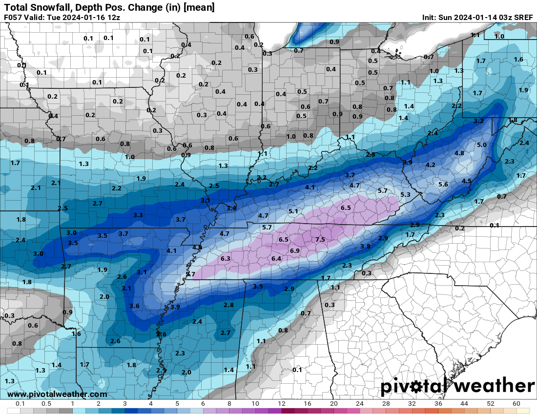
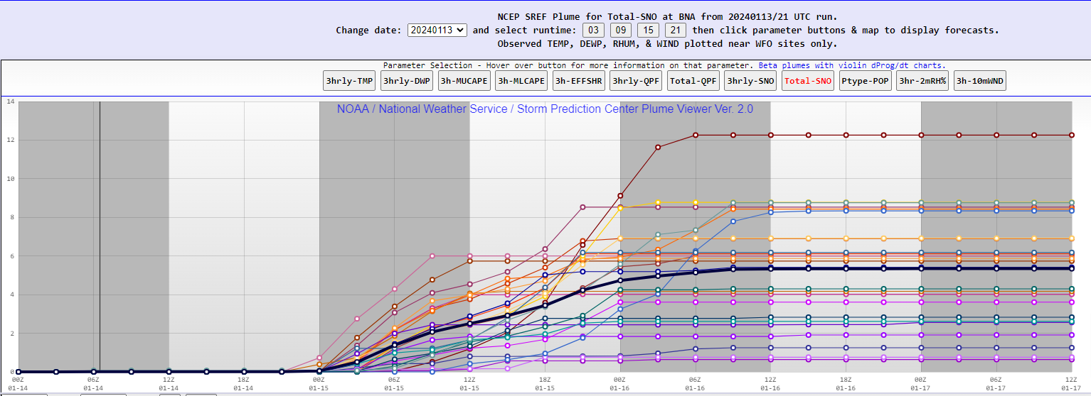
5 minutes ago, John1122 said:
SREF snow depth mean change. This is pretty impressive for a mean for snow depth.
-
1
-
-
6 minutes ago, dwagner88 said:
It appears to have given my area a little more buffer to the southern edge. It got more of northern GA this time.
Good luck to yall,man you stole the snow dome from Nashville it seems
-
2 minutes ago, Reb said:
I’m too invested at this point for that very valid point to matter much to me
 3 minutes ago, Reb said:
I’m too invested at this point for that very valid point to matter much to me
Ill watch it for the Friday system,Euro lost it today somewhat but the GFS still has it,who know at this point
-
6 minutes ago, Reb said:
Anyone doing a Euro play by play?
Think its mesoscale now,i doubt the Euro will change much myself
-
-
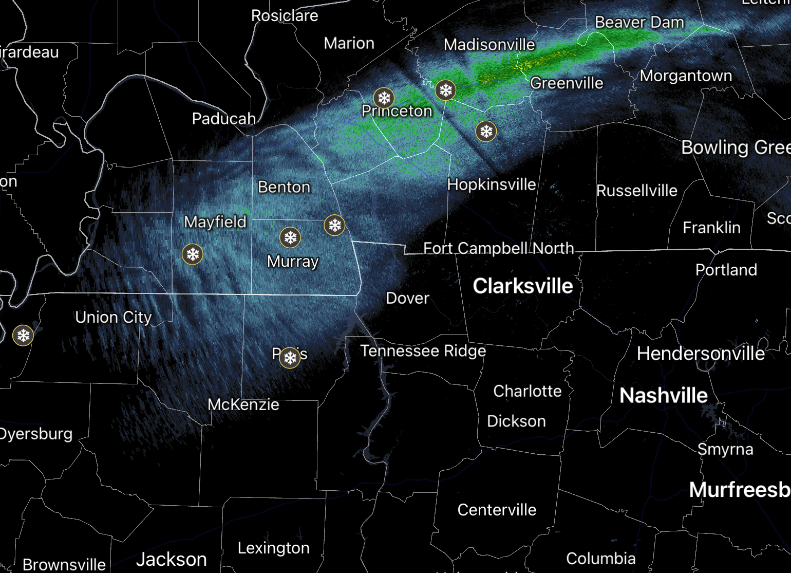
26 minutes ago, bearman said:
What is the light snow coming in to West TN and Southern KY. associated with.

National Weather Service Nashville TN
1054 PM CST Sat Jan 13 2024

...New AVIATION...

.UPDATE...
Issued at 852 PM CST Sat Jan 13 2024

We are about to take the cold plunge. Taking a look at some 00Z
models tonight, messaging remains the same for 3 to 4 inches of
snow to fall areawide starting Sunday evening and through the
entire day Monday. Some areas could see larger accumulation
amounts between 5 to 6 inches in any heavier bands that move
through. Looking at the near term, the sharp cold front bringing
the first real blast of arctic air is right on the cusp of western
TN. The coldest air tonight will be across the western half as
the cold front drapes across Middle TN. Lows across all of Middle
Tennessee tonight will range from 10s in the NW to 20s in the SE.
Highs tomorrow will struggle to reach 30 with many places
struggling to reach 25. Temperatures are not forecast to get
above freezing again until Thursday, so that is close to 110
consecutive hours below freezing. PLEASE check in on those most
vulnerable and prepare accordingly for an extended period of
bitterly cold temperatures.
-
12 minutes ago, bearman said:
What is the light snow coming in to West TN and Southern KY. associated with.
The pic Reb showed below your post shows it
-
2
-
-
10 minutes ago, bearman said:
What is the light snow coming in to West TN and Southern KY. associated with.
CF
-
1
-
-
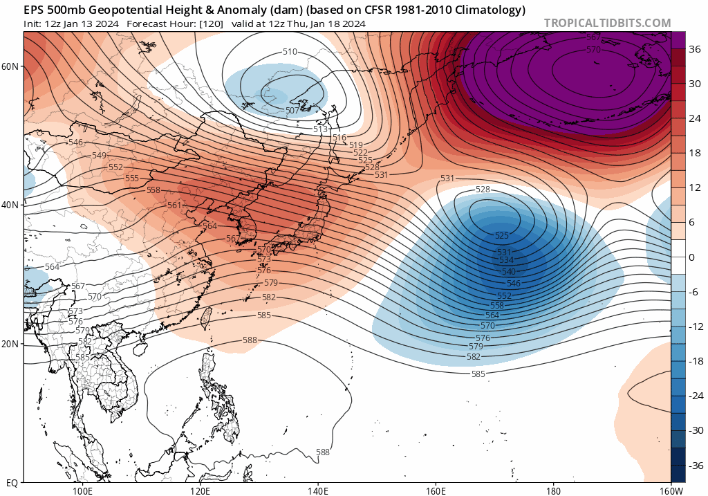
Looks like we will warm up some again.MJO looks strong right now as it gets into the Maritime and WP,but we still should be under the influence of Nino,The SOI yesterday is showing more Nina
13 Jan 2024 1012.32 1002.65 23.84 -1.58 -5.00 12 Jan 2024 1011.79 1004.40 13.10 -2.63 -5.40 11 Jan 2024 1011.80 1005.55 7.73 -2.92 -5.60 10 Jan 2024 1010.99 1006.05 1.56 -2.96 -5.74 9 Jan 2024 1011.83 1006.90 1.51 -3.07 -5.76 8 Jan 2024 1013.35 1008.45 1.37 -3.46 -5.81 What the ensembles are showing into next week East China and Korea will see height rises for a few days then a trough will go through East Asia and just like earlier in the season the heights will fall again in those parts.It shouldnt be a brutal warm up least right now it seems in our parts

-
2
-
 1
1
-
-
Id be happy to get WSW criteria right now,seems like we've been following this system since last winter...i'm getting tired..lol.Might be more wise now to follow the mesoscales.
-
4
-
-
wonder how the globals incorporate the data at this time frame in the Valley,its rare to have cold air to be in place already...dunno
-
3
-
-
National Weather Service Nashville TN
207 PM CST Sat Jan 13 2024

...New SHORT TERM, LONG TERM...

.SHORT TERM...
(This afternoon through Sunday Night)
Issued at 200 PM CST Sat Jan 13 2024

Our main concerns continue to be the developing bitter cold and
snow. After temps fall below freezing tonight, they are not
expected to reach freezing again until Thursday. Cold wx
precautions should be implemented, and we encourage plans to make
warming shelters available throughout the next several days.
Significant snow accumulations are expected to begin Sunday
evening and continue through the day Monday and into Monday night.
Our forecast shows 3 to 4 inches for most of the area. Our
northwest counties may come in on the low side of that, while
some enhanced bands of snowfall could produce localized amounts of
5 to 6 inches in some spots along and south of I-40.

Before the big storm arrives, we will have a cold frontal passage
tonight that will reinforce the Arctic air. This front will be
accompanied by a brief band of snow flurries or showers. Areas
along and north of I-40 may see a dusting late tonight, especially
for areas along the KY border.

Sunday will be dry for most of the day and very cold. Highs will
not climb out of the 20s for most of us. Light snow will start to
spread into our far western counties after 3 PM.

Light snow will blossom across the area Sunday evening, then the
intensity will gradually increase late night. By daybreak Monday,
most areas will see the ground getting covered, and up to 1 inch
may accumulate for the west half.

&&

.LONG TERM...
(Monday through next Saturday)
Issued at 200 PM CST Sat Jan 13 2024

A Winter Storm Watch remains posted for Sunday evening into
Tuesday morning. Models have come into better agreement
confidently depicting widespread snowfall amounts in the 3 to 5
inch range. This will occur as a broad upper level disturbance
crosses the region with deep cold air already in place. Often we
deal with precipitation type changes in our winter forecasts, but
this one will be all snow. A 120KT upper level jet stream will set
up with Middle Tennessee located under the favorable right
entrance region throughout Monday. Moisture will be deep through
the atmosphere and forecast soundings show very favorable thermal
and moisture profiles for the growth of snowflakes. The area will
also be within a low to mid level frontal convergence zone. All
of this means high confidence in snow with potential for enhanced
bands of snow setting up, giving locally greater totals, perhaps 5
or 6 inches in some spots. It is hard to know exactly where the
bands will develop, but even the generalized totals of 3 to 5
inches will cause significant travel impacts. Also, with such
cold air in place, the snow will stick right away and it will
stick around as temps stay sub-freezing until Thursday.

The cold air with the snow and after the snowfall will not be
record-setting (most records are well below zero), but it will be
dangerous for vulnerable populations as wind chill values will
fall below zero. So, a wind chill advisory may ne needed,
especially early Tuesday morning and early Wednesday morning.

As if the early to mid-week wx festivities were not enough, we
are looking at another shot of accumulating snow later in the
week, perhaps 1 inch for late Thursday into Friday!

&&
-
1
-
-
-
NAM shows a warm nose now all the way to Nashville,steals some of the snow fall here into zr/ip at times
-
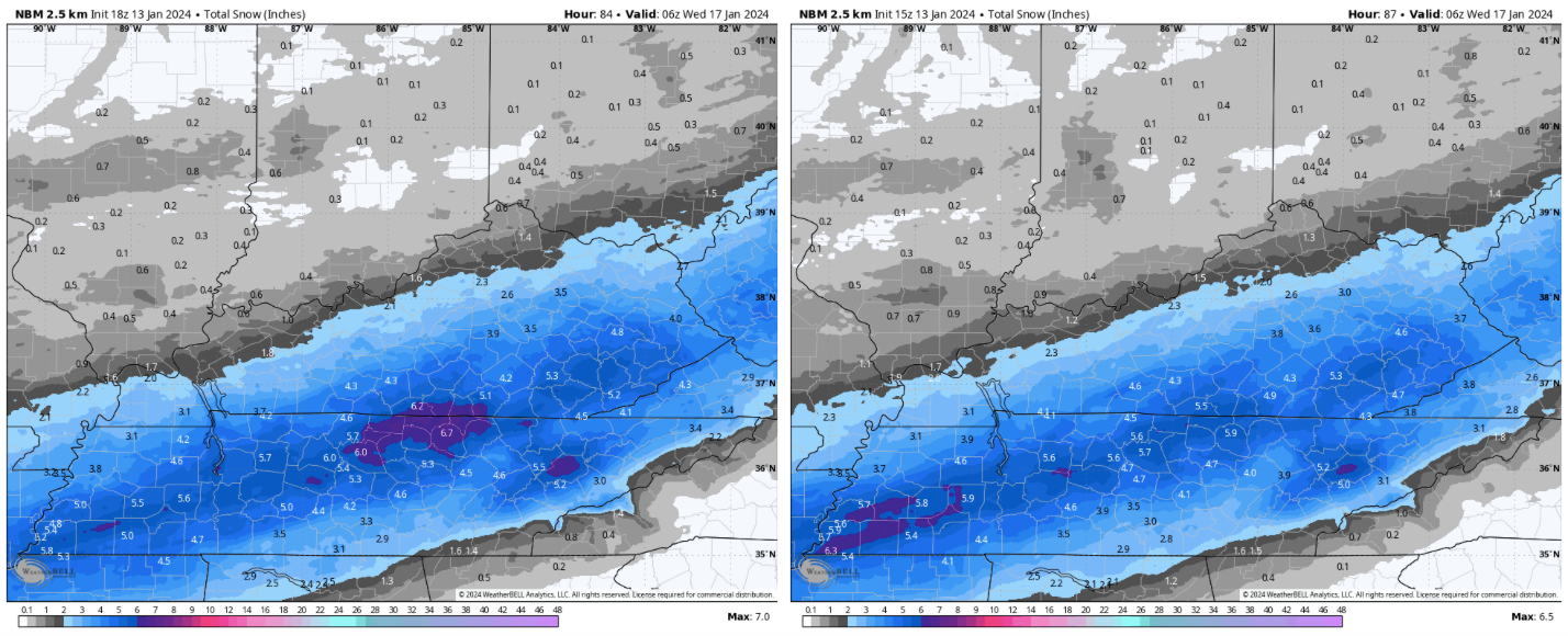
2 minutes ago, Carvers Gap said:
18z NBM looks about right to me. New run is on the left. One last thing I will be watching on models is if they beef-up their qpf as El Nino systems are often under modeled. Looks super similar to the HRRR. But we need the Euro on board. If that is right, there will be some spots w/ 10+" of snow.
Looks like the % of WPC this morning,they show parts of the Cumberland getting smacked
.png.db959aa34c1950e9547d5a7c2d4c17ab.png)
January 15th-17th 2024 Arctic Blast/Snow Event
in Tennessee Valley
Posted
RAP looks more North than most guidance last run