

jaxjagman
-
Posts
8,302 -
Joined
-
Last visited
Content Type
Profiles
Blogs
Forums
American Weather
Media Demo
Store
Gallery
Posts posted by jaxjagman
-
-
Still don't' believe the Euro is right with the MJO.it's having distructive interference from the CCKW in the Maritime right now and in the end it will be in the WH much quicker than its showing
.png.011b5ba764a329a5f22ed9d7962ab709.png)
-
 5
5
-
-
CFS has been much faster with the signal,shows it getting into the WH before or about the next 2-weeks
-
2
-
-
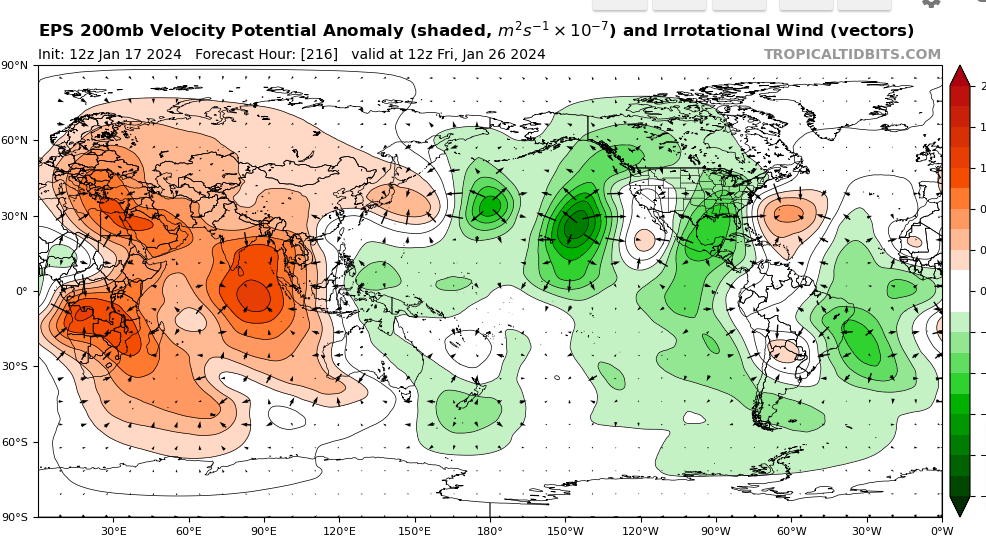
GTH Outlook Discussion Last Updated - 01/16/24 Valid - 01/24/24 - 02/06/24 Following a period of weakening over the Indian Ocean earlier this month, the MJO became much more organized during the past week. Latest RMM observations show the MJO signal propagating eastward into the Maritime Continent (phase 4), and steadily gaining amplitude, which is well reflected by a reemerging wave-1 pattern in the 200-hPa velocity potential anomaly fields. A large uptick in MJO amplitude is heavily favored in the dynamical models during the next week, which appears to be tied to constructive interference with a convectively coupled Kelvin Wave propagating out of the Indian Ocean. This wave phasing is likely to promote widespread enhanced convection over the Maritime Continent, which has been otherwise persistently dominated by a suppressed convective El Nino response.
Even with the MJO continuing to destructively interfere with the low frequency El Nino conditions, intraseasonal activity is largely favored to remain coherent during the next several weeks. Very good agreement exists in the RMM forecasts depicting a high amplitude event propagating eastward into the Western Pacific during the next two weeks, where the MJO looks to eventually constructively interfere again with base state over the Equatorial Pacific. Ensemble spread increases in the extended range, however many solutions (especially the GEFS) continue to maintain a high amplitude event, taking the MJO signal back into the Western Hemisphere by the first or second week of February. A healthy, eastward propagating MJO is expected to provide increasingly favorable conditions for Tropical Cyclone (TC) development over parts of the southern Indian Ocean, as well as the Western Pacific on both sides of the Equator. And in light of aforementioned convective pattern reversal favored over the Maritime Continent in the near term, this could induce a stronger MJO teleconnection in the extratropics downstream. Wintertime Indian Ocean and Maritime Continent MJO events typically lead to the development of anomalous mid-level ridging with warmer than normal temperatures over the central and eastern U.S. This is consistent with the latest week-2 guidance, however there is also both model and historical support for the associated anomalous mid-level ridging to retrograde over western North America with time, potentially allowing for the return of colder than normal temperatures over parts of the U.S. heading into February..png.e689e77c21b9c552e3f2b0e6205246a5.png)
-
3
-
 1
1
-
-
16 minutes ago, Matthew70 said:
What does this mean? Rain? Hopefully not ice.
Euro seems to be showing more of a inverted trough into Mid Tn compared to the GFS,thats why you dont see such a strong LLJ into Mid Tn,its snow to the north and mixing towards the AL/Tn line here in Mid Tn.GFS
-
1
-
1
-
-
Euro shows a 35-45 LLJ,over Mid Tn,lower elevation wont stand a chance here basically up to the Ky line
-
1 minute ago, John1122 said:
Is anyone in the band north of Nashville? It's showing a 45dbz streak on the NWS radar.
Think thats where Flash lives
-
1 minute ago, Silas Lang said:
Same here. Just hit the 4 inch mark. Adding up faster now. Still holding strong at 29.
Yeah we did good with this system,should be around 8" so far,ill go out and measure it later today
-
1
-
-
4 minutes ago, John1122 said:
Crossing 4 inches as the air is filled with pixie dust. It actually warmed up to 23 degrees earlier but dropped back to 21 now.
Mountains play havoc with weather,its 12 here
-
3
-
-
1 minute ago, PowellVolz said:
Dang. That usually works for me. Definitely A server issue
.I know,for some reason when i try to load the 2nd pic it says its to big
-
1
-
-
1 minute ago, PowellVolz said:
Load the pics one at a time
.I tried,its never done this before
-
1
-
-
1 hour ago, *Flash* said:
So, I know the event is still ongoing...and I need to get caught up on about 15 pages of comments. In terms of modeling W's and L's, how are we breaking down performance? Certainly, NOT a win for the Euro at least for my area...
Thought the NAM was the big winner in our parts,EURO was the big loser
-
3
-
-
-
-
Server isnt allowing me to post all together for some reason
-
3
-
-
3 minutes ago, Mrwolf1972 said:
Looks like the heavier snow will set up in valley around 9am and stay there all day hope that pans out.
Sent from my SM-S916U1 using Tapatalk
Short range models still show the secondary later on
-
1
-
-
thats a nice band fixiing to hit theCunberland
-
1
-
-
3 minutes ago, John1122 said:
There's a heck of a band through Nashville that hopefully heads your way.
i saw Nashville should have a decent shower,we seem to have gotten split this time
-
kinda hit a lull recently but picking up again should be getting some decent snow here soon
-
1
-
-
8 minutes ago, Highway2Heel said:
A solid 4” in Columbia and moderate snow continues.
Thx you look to be under a decent band right now
-
2
-
-
NAM is gonna thump the Globals once again even in its extended range of it,im getting impressed with it myself as of late
-
2
-
-
some bigger flakes now here,we look to be 2-3" right now,radar look good again to our west recently
https://g1.ipcamlive.com/player/player.php?alias=brentwood201173a
-
5
-
-
not sure about Chatty tho,look more of a mix right now
-
Starting to fizzle out in the NW,models though have shown this.HRRR shows it snow tho in most of all Tn through the day it seems
-
1
-
-
2 minutes ago, Dsty2001 said:
Wife just yelled at me cause I keep going outside, took some extra sleepy time medication otherwise I'll be up all night watching radar and going outside lol
My wife says the same thing,did you lock the door

-
3
-
 6
6
-

January Medium-Long Range Discussion
in Tennessee Valley
Posted
We will see,but it sure looks like its gonna be more progressive,MJO