

jaxjagman
-
Posts
8,699 -
Joined
-
Last visited
Content Type
Profiles
Blogs
Forums
American Weather
Media Demo
Store
Gallery
Posts posted by jaxjagman
-
-
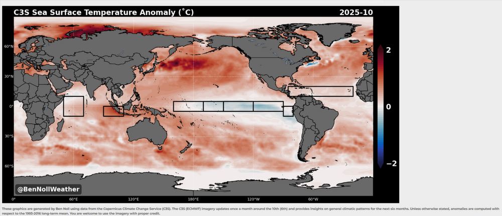
Pattern what CANSIPS is showing right now looks maybe similar to last winter.More NINA, weak NINA.I'm surprised it didnt show more blocking into the Hudson with the blocking its showing into around the four corners,but it still looks like a -NAO.Jan would seemingly right now be BN with the blocking its showing into the Western AK/.Bering Sea.Into Feb this blocking shifts into the Bering Sea,this seemingly could bring a early severe threat
Think myself the warm SST'S into the Yellow Sea into the Sea of Japan and off the east coast of Japan are unprecedented to rely on analogs.I mean the warmest SST'S in this region was in 2023 during a strong NINO
-
40 minutes ago, nrgjeff said:
Unfortunately lots of scattered but significant damage is reported in North Alamba. James Spann posted. Also saw text reports from EMs. Sad deal more like an April event. Haven't heard much from the Nashville 'burbs. Meanwhile sups split Chattanooga so we lucked out here.
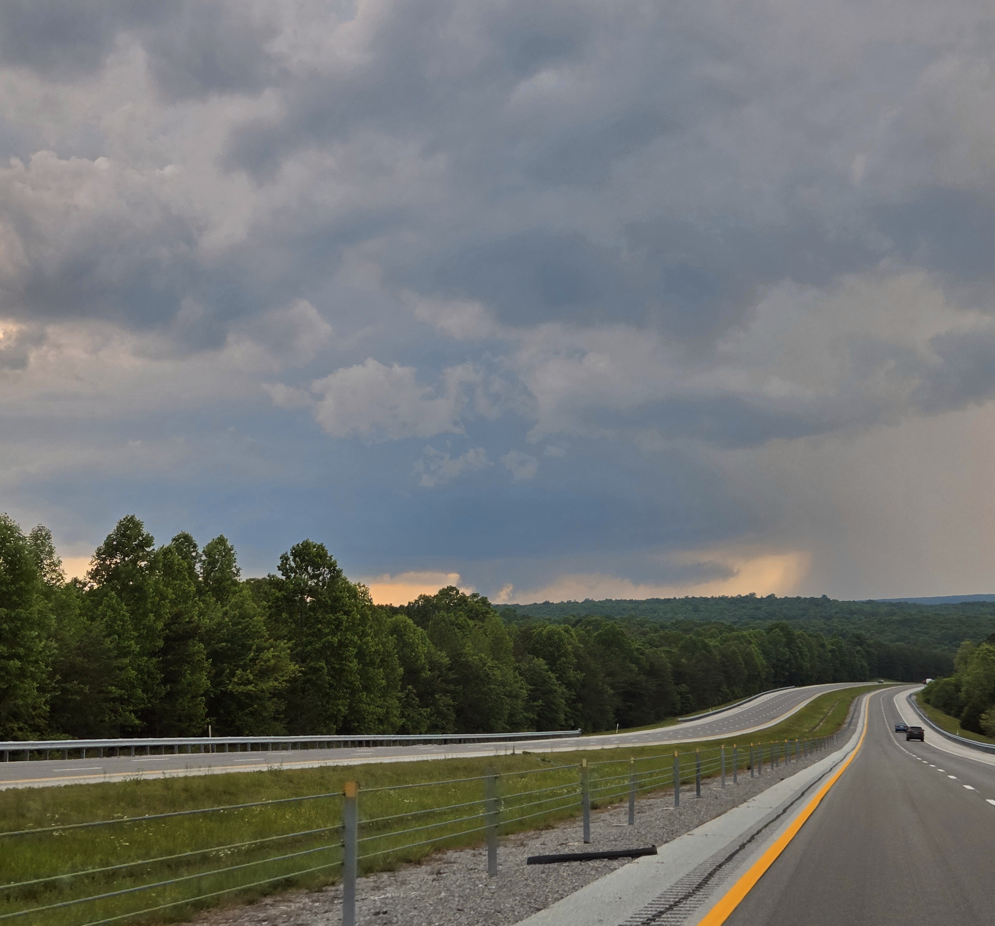
I was unable to truly chase on Tuesday due to work requirements. However during a lull between the Cherokee, AL / Pickwick Reservoir tornado and evening trouble I was able to get out locally.
A severe warned cell (actually the Cherokee cell hours later) tracked from Monteagle, to Dunlap, to Soddy Daisy all Tennessee. I-24 is a no-fly zone for me at rush hour, so no Monteagle, but I was able to track it from Dunlap to Soddy just north of Chattanooga. It was between 6-7 pm EDT before the Madison, AL and Huntsville stuff got really ugly.
Here are my low-lights. While the first is arguably structure out of the spotter's guide, less crisp but good for East Tenn... the rest is scuddy crap. Oh well! At least I got out of the house.
So while the Cherokee cell stopped producing tornadoes, it retained supercell characteristics for several hours. I believe it was on the intersection of the outflow boundary and a prefrontal trough. Evening cells were associated more with the main surface trough - enhanced by the same outflow boundary.

No clue what happened here other than hail and wind,i thought some of the cells should have been tor warned sooner and a couple that should have been warned that wasnt,but thats just me.I know there was some large hail over 2" in Franklin and other places as well,we just got wind here,i didnt see no hail.I thought Morristown was suppose to do our weather here basically,sure they were busy also.
-
 1
1
-
-
2 hours ago, yoda said:
Did NWS Nashville lose power or shelter? All of their warnings and updates are coming from NWS Fort Worth the past 20 minutes
More than likely because they are updating AWIPS this week and couldnt reschedule.They gave the public advance notice because some things might be down at times along with NOAA radio the next few days
-
2
-
-
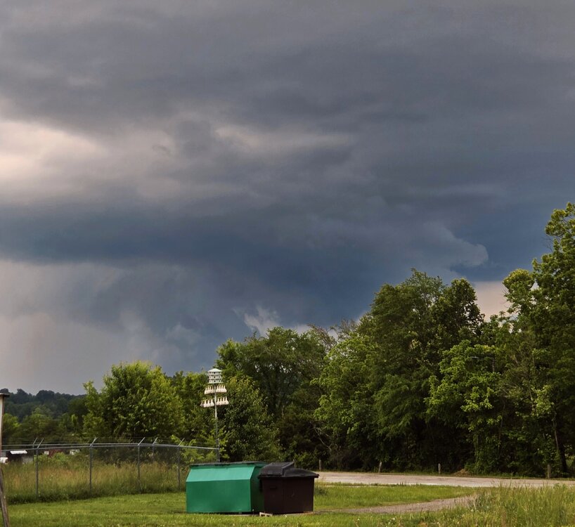
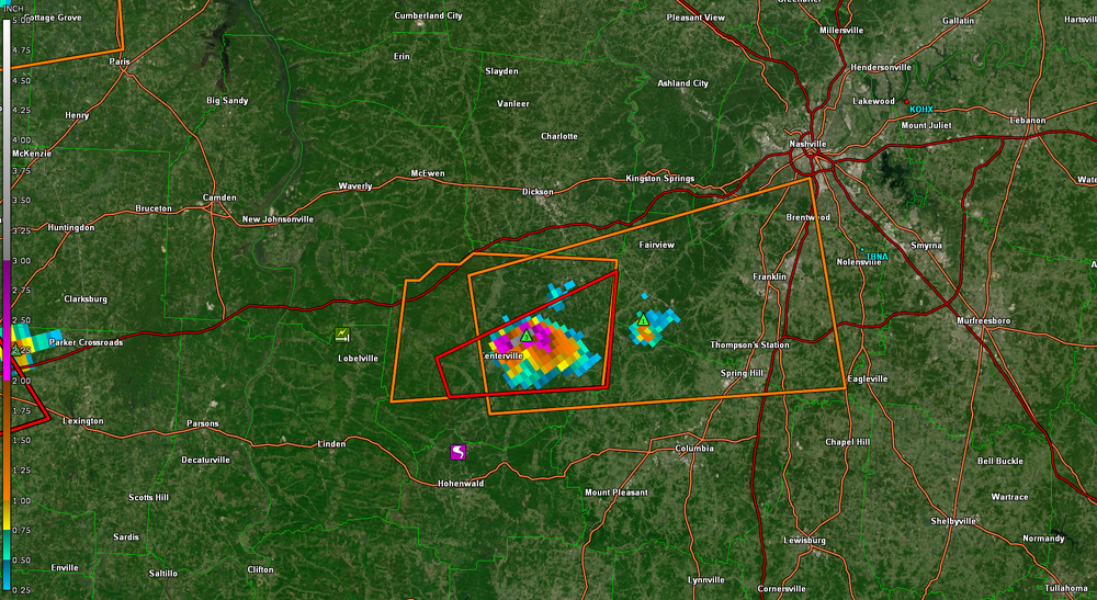
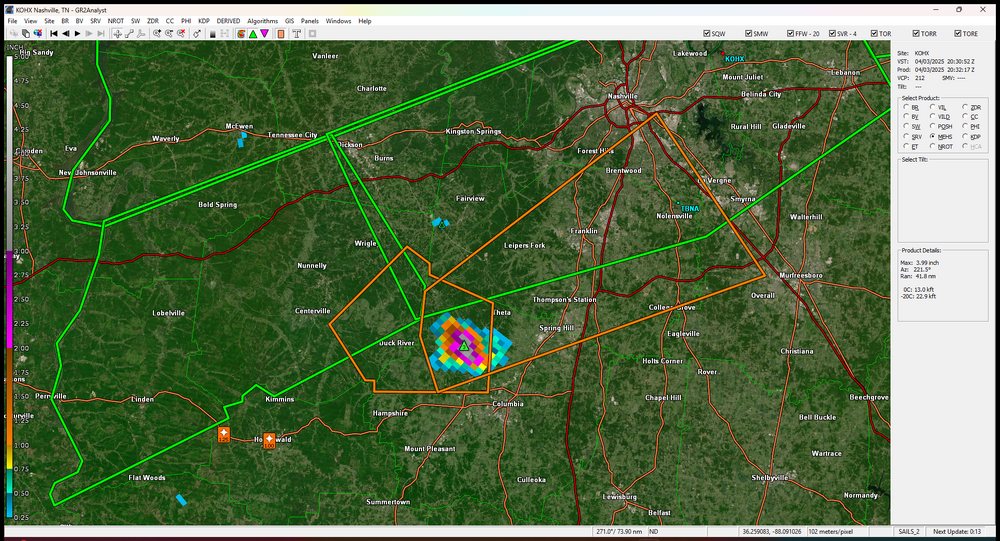
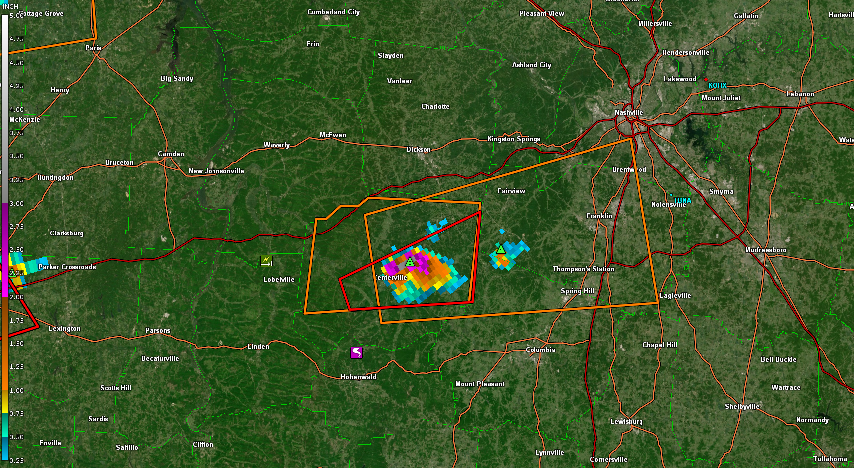
Some big hail ,the Centerville cell
-
Confirmed Tor headed towards maybe Duck River
-
 1
1
-
-
Confirmed Tor headed towards maybe Duck River
-
8 hours ago, Matthew70 said:
Tuesday. Tuesday. Does the trend continue to keep tornadoes away from the state. We shall see.
Could be Monday as well,where ever the boundary sets up.GFS has been showing this for several runs now,but Tuesday looks better as you mentioned
  ...Portions of the TN Valley...
   Multiple rounds of thunderstorms are possible along a residual
   baroclinic boundary across the TN Valley, both during the morning
   hours, and later in the evening. While not quite as unstable as
   points farther to the west, modest mid-level lapse rates amid
   elongated hodographs should support multicells, supercells, and
   short line segments. The stronger storms may be capable of isolated
   instances of large hail, gusty winds, and perhaps a brief tornado.
-
 2
2
-
-
That cell is trucking 70mph
-
Be interesting how the ENSO plays out into severe fall.I know some of the NMME'S has been showing a resurgent Nina.But by BN's maps and some of the NMME'S i'd think the GOM could get rather active from June -Aug,thats JMHO.
https://www.bennollweather.com/climate-graphics
-
We got some P-sized hail for about 5 min then the non severe winds kicked in.Glad we didn't get 2" variety,i already had to replace two windshields from the winter storms.My wife tried to run the wind shield wiper in which was stuck in her car,it ended up cracking the window all the way across where the both wipers were,daughter poured hot water on the winshield,that didnt work out very well..lol
Soon as the ULL gets kicked out around mid week next week it looks fairly unstable for a few days anyways right now..Nashville is already saying it's favorite words.Stay Tuned!!
-
1
-
 1
1
-
-
Made it to 86 today,one degree F from tying the record
-
2
-
-
On 4/14/2025 at 3:50 PM, nrgjeff said:
Yes the center of the action should gradually shift north and west into the Great Plains. Southern season still has a few more weeks though. See if this weekend Plains system can hold together into the South next week.
Then the far extended end of April forecast is very up in the air. Looks like decent flow is forecast across the Lower 48. Whether it's southwest flow (Plains) or choppy remains to be seen. Choppy version would be less intense but might allow rain into our region.
Looks messy everywhere,dont look like no big tor outbreak like twitter is telling the world..lol.Our area for most of us shows piss poor lapse rates no lift,etc.,etc to early to say next?
-
1
-
-
This winter will likely seemingly be warm,its rare to see back to back cold winters in our parts,we had plenty of chances to get a decent snow storm but nooooooooo..it happened down in or around the GOM,in which i feel really annoyed about,they got 2x,3x more snow than what we got here in a day than what we got in the season

-
1
-
1
-
-
14 hours ago, vortexse93 said:
I am hoping to get an early May chase in this year if schedule allows. Late April will have to be local for me unfortunately.
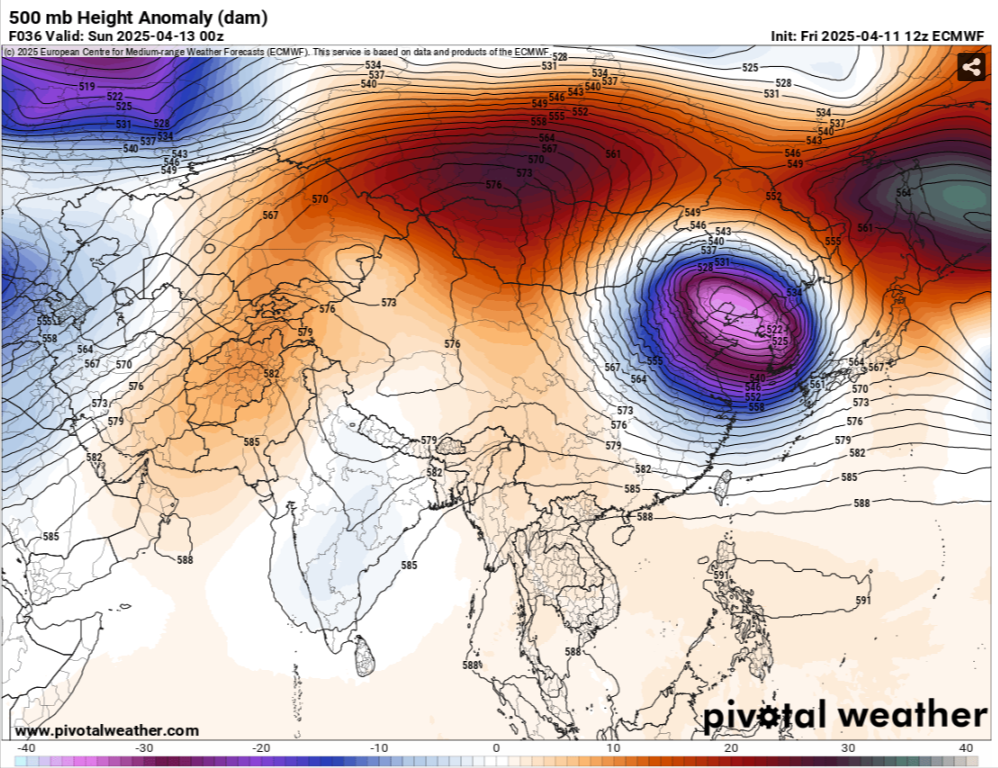
Really like this set up for us.But we will see,just say there is a chance for now,When you start to see a ridge into Mongolia, ULL headed towards the Koreas and ridge into the Sea of Okhotsk into the Bearing Sea,this is normally severe in our parts,but there will always be some sort of a HP in the East that could very well cut off the moisture flux
-
1
-
-
On 4/6/2025 at 5:14 PM, jaxjagman said:
Think we should have a decent chance of severe as we get around the 20-21 of April.Thats a strong ULL coming into from East China into the Koreas next weekend,all the models are showing this with rising heights into Mongolia and Japan,looks kinda meh until then,dont mean you cant get severe just looks meh
Might be a day or two later but thats not a weak Upper Level Low going through East Asia the next day or two.With heights rising into Mongolia and Japan,i'd be surprised myself if the models dont start showing a more severe threat in the upcoming runs

-
1
-
 1
1
-
-
Think we should have a decent chance of severe as we get around the 20-21 of April.Thats a strong ULL coming into from East China into the Koreas next weekend,all the models are showing this with rising heights into Mongolia and Japan,looks kinda meh until then,dont mean you cant get severe just looks meh
-
2
-
-
11 minutes ago, vortexse93 said:
This will be way outside of my chase zone. I am in Jackson, MS so will need something in Greenville, MS at the very least
We had a tornado contest years ago here,I'd always pick Yazoo City in those parts when in storm mode,that town is a tornado magnet..lol
-
1
-
1
-
-
-
24 minutes ago, vortexse93 said:

It has been a crazy for me, as I am sure it has been for a lot of people within this group. I do want to get a quick post out before things get a little more crazy this afternoon and evening.For chasing, I have two options in mind to target and these two options are more than doable given my close proximity.
Option 1). First option and most ideal, will be head towards Vicksburg, MS this afternoon as it gives me the best option to either head north or continue west into Louisiana. Model guidance shows the potential for discrete cells out ahead of the mainline and in the open warm sector. Secondly, this option allows me to head north into the Mississippi Delta in the event storms decide to track more northward and will still give me plenty of time for a potential intercept.
Option 2) This option is a little more aggressive as it leans more towards the RRFS model run and will require a more northward positioning for myself (please take this option with a grain of salt). This option will take me straight into Yazoo City before going into Mississippi Delta. While drive time overall will not change, however, the RRFS is more aggressive with showing the potential for discrete cells further north into Greenville, MS. This northern route will allow me to be closer to Greenville, MS vs Option 1. I do want to point this out, Option 1 still allows me to go northward if needed. However, with Option 2, I am more set on staying north and not as likely to have a viable west option into Louisiana if storms develop before crossing the river.With this being said, I am monitoring the current weather conditions and really waiting on to see if SPC puts another MESO Discussion over Central MS anytime soon. I am close enough to where I can wait and see what happens before making a drive towards either option this afternoon. It is a waiting a game at this point.
Be watching Auburn so im staying home.Some of the latest Mesoscales look better south of Memphis about 50-75 miles give or take,thats around mid afternoon,it dont look bad even where you are at later
-
 1
1
-
-
On 4/3/2025 at 1:14 AM, John1122 said:
It's ridiculously warm. 71 at 2am, Oak Ridge is 77 with a heat index of 79, talk about summer hitting immediately.
I went to bed about 11AM Wed night before the storms here came trough and it was still 81.Today here we made it to 87 high,Nashville OBS says it was 86 so it missed the record of 87 in 1934
-
3
-
-
Big HAIL
-
NROT IS UP TO 2 now that cell headed towards Thompsons Station
-
That sure look like a tornado to me..lol
-
Centerville is showing rotation also now


TV Severe Weather2025-?
in Tennessee Valley
Posted
Like to find the weather charts and see this
across Middle Tennessee, beginning on the afternoon of the 28th, and
continuing into the next morning. All tornadoes are classified as F2.
One person is killed in Davidson County. Another 38 injuries are
reported overall.