dendrite
-
Posts
75,081 -
Joined
Content Type
Profiles
Blogs
Forums
American Weather
Media Demo
Store
Gallery
Everything posted by dendrite
-
 Hopefully more heat and smoke soon
 -
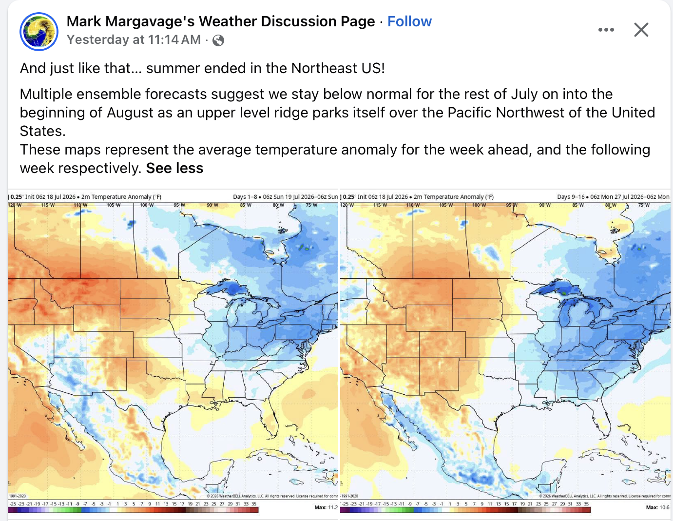
Pretty crazy that summer is over on 7/19

-
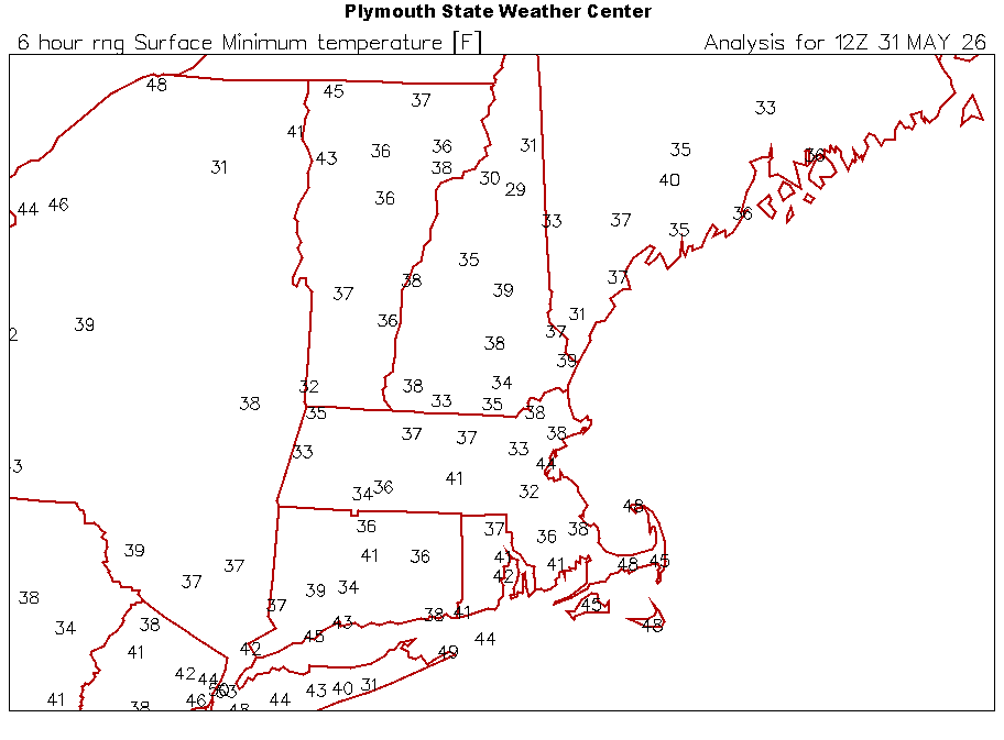
Should be some 40s at the rad sites tomorrow morning.
-
62/53 and ovc with wind is a little chilly for me in July. It feels like mid September out there.
-
In the Canadian forests
-
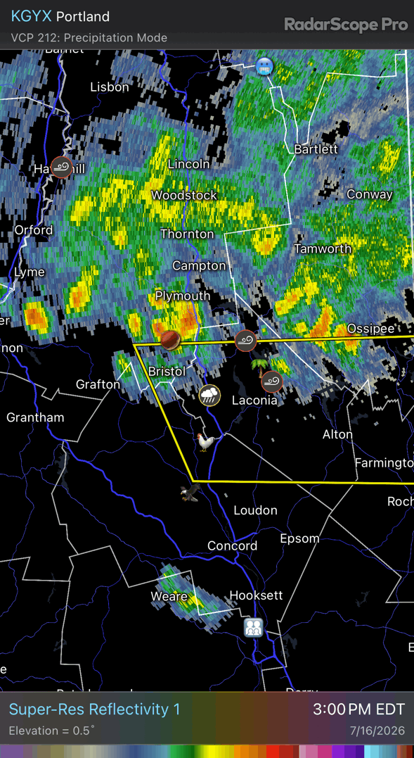
Huge COC today into tomorrow
-
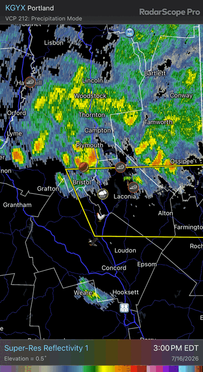
Saturday, July 18, 2026 Thunderstorm/Severe Weather Potential
dendrite replied to weatherwiz's topic in New England
Ditto here this month. And I’m willing to flood CT until I can get it. -
Saturday, July 18, 2026 Thunderstorm/Severe Weather Potential
dendrite replied to weatherwiz's topic in New England
18z hrrr had that pegged -
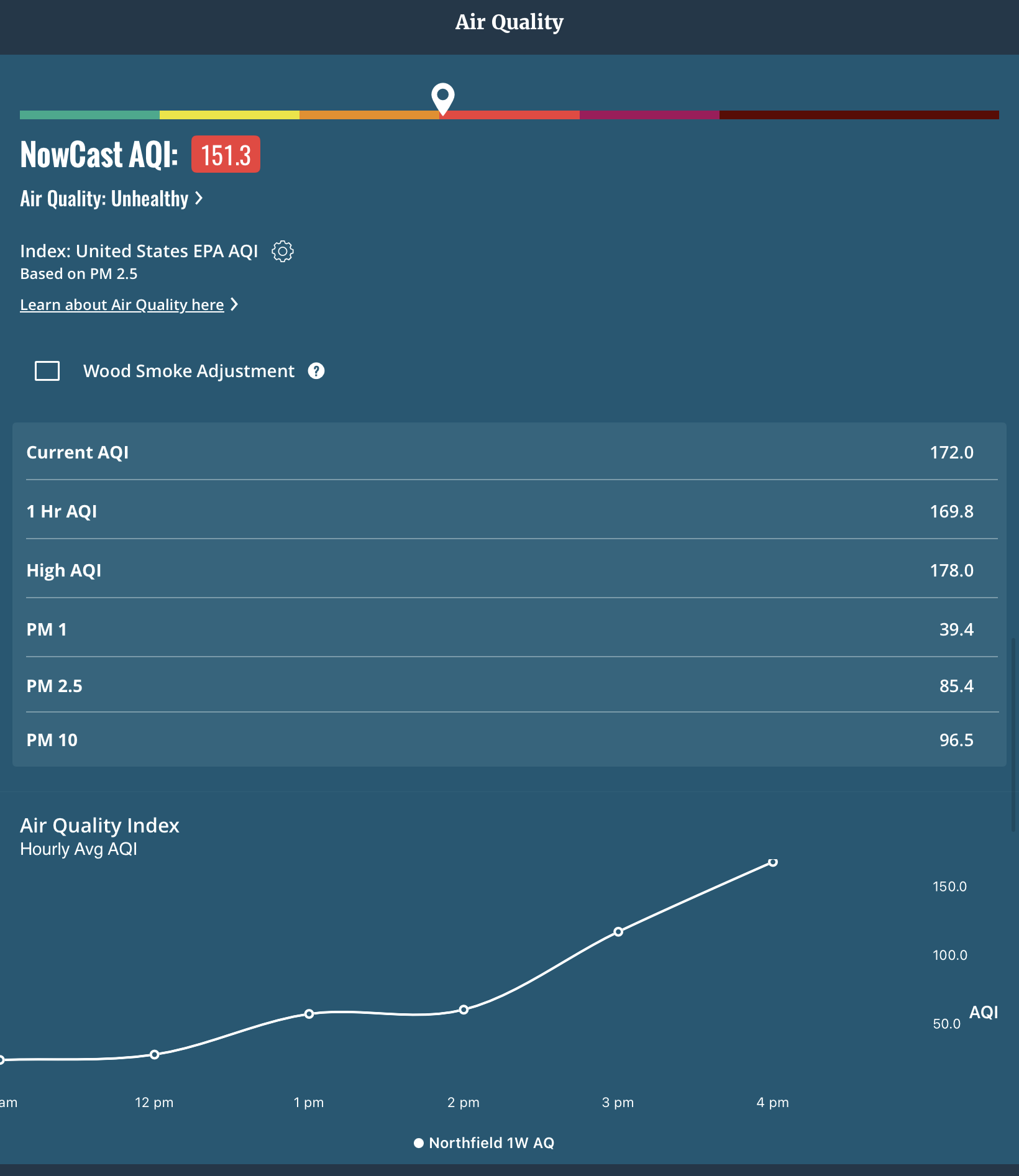
AQI gone wild here post rain

-
Saturday, July 18, 2026 Thunderstorm/Severe Weather Potential
dendrite replied to weatherwiz's topic in New England
About the same here. 0.28” so far -
Saturday, July 18, 2026 Thunderstorm/Severe Weather Potential
dendrite replied to weatherwiz's topic in New England
Bitched myself to some rain. Channeled my inner tblizz. No new wives though. -
Saturday, July 18, 2026 Thunderstorm/Severe Weather Potential
dendrite replied to weatherwiz's topic in New England
Wow is his webbed grip strong. I apologize for the emoji. Please let it rain.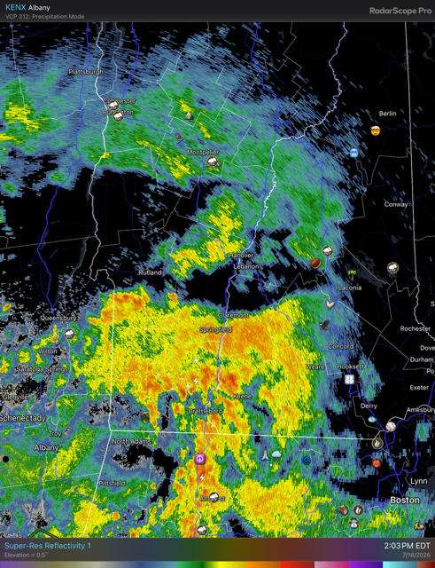
-
Not much smoke here yet A heavy trace of rain this morning
-
134kt is pretty good for 7/20. A little snow and sleet mixed in too. KMWN 200458Z 28071G95KT 0SM -SHRA FG VV000 03/03 KMWN 200552Z 27067G78KT 0SM FG VV000 03/03 RMK SHRAB15E40 DZE40 KMWN 200652Z 28082G92KT 0SM -DZ FG VV000 02/02 RMK DZB30 KMWN 200759Z 28076G103KT 0SM -DZ FG VV000 01/01 RMK PRESFR KMWN 200955Z 27090G107KT 0SM -DZ FG VV000 02/02 KMWN 201150Z 27093G115KT 0SM -SHRA FG VV000 02/02 RMK SHRAB20 KMWN 201257Z 28099G116KT 0SM -SHRA FG VV000 02/02 KMWN 201355Z 28083G92KT 0SM -SHRA FG VV000 01/01 KMWN 201453Z 27079G95KT 0SM -SHRA FG VV000 01/01 KMWN 201555Z 27076G97KT 0SM -SHRA FG VV000 KMWN 201650Z 26076G104KT 0SM -SHRADZ FG VV000 01/01 RMK DZB30 KMWN 201750Z 27086G107KT 0SM SHRASN FG VV000 01/01 RMK DZE15 PEB15 SNB20 PEE45 KMWN 201854Z 27095G111 0SM -SHRASN FG VV000 01/01 KMWN 201952Z 280106G125KT 0SM -SHRASN FG VV000 02/02 KMWN 202052Z 280101G124KT 0SM SHRA FG VV000 02/02 RMK SNEPEB10PEE30 PK WND 280134/32 KMWN 202202Z 280103G126KT 0SM -SHRA FG VV000 02/02 KMWN 202250Z 28088G120KT 0SM SHRA FG VV000 02/02 KMWN 202345Z 28088G126KT 0SM SHRAPE FG VV000 02/02 RMK SHPEB40 KMWN 210050Z 28083G115KT 0SM SHRA FG VV000 02/02 RMK SHPEE35 KMWN 210055Z 29039G52KT 0SM FG VV000 05/05 KMWN 210155Z 30034G39KT 0SM FG VV000 06/06 KMWN 210251Z 28090G115KT 0SM 02/02 RMK T00200020 KMWN 210255Z 30039G54KT 0SM FG VV000 05/05 KMWN 210354Z 32034G43KT 100SM FEW/// SCT003 SCT030 05/05 RMK TPS LWR SCT055 W T00540045 KMWN 210459Z 32028G36KT 100SM FEW/// SCT003 SCT030 05/05 RMK TPS LWR FEW055 W T00540045
-
38° at SLK
-
Maybe they’re literally on fire? China interfering with smoke physics?
-
53.4° Frigid
-
Already 63° and clear Chilly!
-
Weekend rain is looking like a fail for us too now.
-
What a local Steining. 5 drops.
-
He moves in mysterious ways
-
Wind is roaring…I can hear trees falling in the woods from the run.
-
Front is coming from the north…FU may sneak into SNE briefly, but it will get mostly pinched off up here.