dendrite
-
Posts
73,510 -
Joined
Content Type
Profiles
Blogs
Forums
American Weather
Media Demo
Store
Gallery
Everything posted by dendrite
-
How do we define “stay there”? I guess when you say it will reload late March I took it as going back to the same pattern we’ve been in…which I would clap back with “we just don’t know”. Obviously 60s and 70s this early are always relegated to 1-5 days at most. But there’s been some good warmth stretches in March aside from 2012. I mentioned 98 the other day. 2010 was warm right through all of MAM. 2021 and 2016 had quite a few warm Mar and Apr days too. But yeah, obviously no one is getting daily 60s and 70s in spring. That’s sorta rhetorical.
-
Do we?
-

"Don’t do it" 2026 Blizzard obs, updates and pictures.
dendrite replied to Ginx snewx's topic in New England
PVD depth is 31” this morning…so they’ve lost 11” since near the end of the peak of the storm. -
"Don’t do it" 2026 Blizzard obs, updates and pictures.
dendrite replied to Ginx snewx's topic in New England
Those rates were large enough that there was a period where they were racking up high ratio snows. Compaction is real especially with big totals like that. I think it’s a little insulting to assume everyone in that 30”+ zone doesn’t know how to measure new snowfall…especially paid, trained observers at PVD. -
I’m trying to make my bet on Kalshi for when you flip from ACATT to AWATT. Do you have any insider tips?
-
"Don’t do it" 2026 Blizzard obs, updates and pictures.
dendrite replied to Ginx snewx's topic in New England
Fake news. CPez said it didn’t happen. -
Although once his pack starts taking a beating and the valley is flirting with 70° the gypsy will emerge trying to rain to Maine and take everyone else’s pack.
-
Lots of neighbor pics in the extended
-
It’s still so far out too with the gradient lurking to the north. GFS actually wedges NH for most of that stretch. But I did have to laugh at some of the +15C 850s on the op and AI models. Where’s Will’s “don’t look at it” gif?
-
If you have a BD concern it would be your first time in 20 years when you were truly ACATT.
-
To be fair…we have warmer winter normals now and the region was in our own pocket of cold. But yeah, the stars aligned down there this year for a consistently cold and snowy winter, with a couple of historical events. It’s been cold up here too, but more tame the further north you go. For a lot of NNE it’s been a meh winter. But it’s nice to see SNE getting a fun one after a relatively crappy stretch the past few years.
-
Freshets for all….need a 3-5” region wide soaker
-
I already know how those 4 days will go here. Day 1…Sunny, pleasant warm & dry 50° Day 2…wedged…38° ovc Day 3…wedged…40° ovc Day 4…torch ahead of the next front… 60°
-
Days and days of 70s on the gfs and euro in sne, but it seems like an eternity away for something not to go wrong.
-
How?
-
"Don’t do it" 2026 Blizzard obs, updates and pictures.
dendrite replied to Ginx snewx's topic in New England
PVD had a 37” depth gain and reported “only” 37.9” new -
2012 is not coming through that door. We were already through mud season when that occurred.
-
"Don’t do it" 2026 Blizzard obs, updates and pictures.
dendrite replied to Ginx snewx's topic in New England
He said he’d like a dirt bike…fyi. -
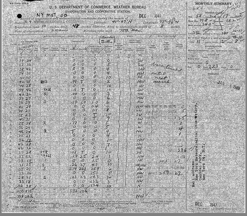
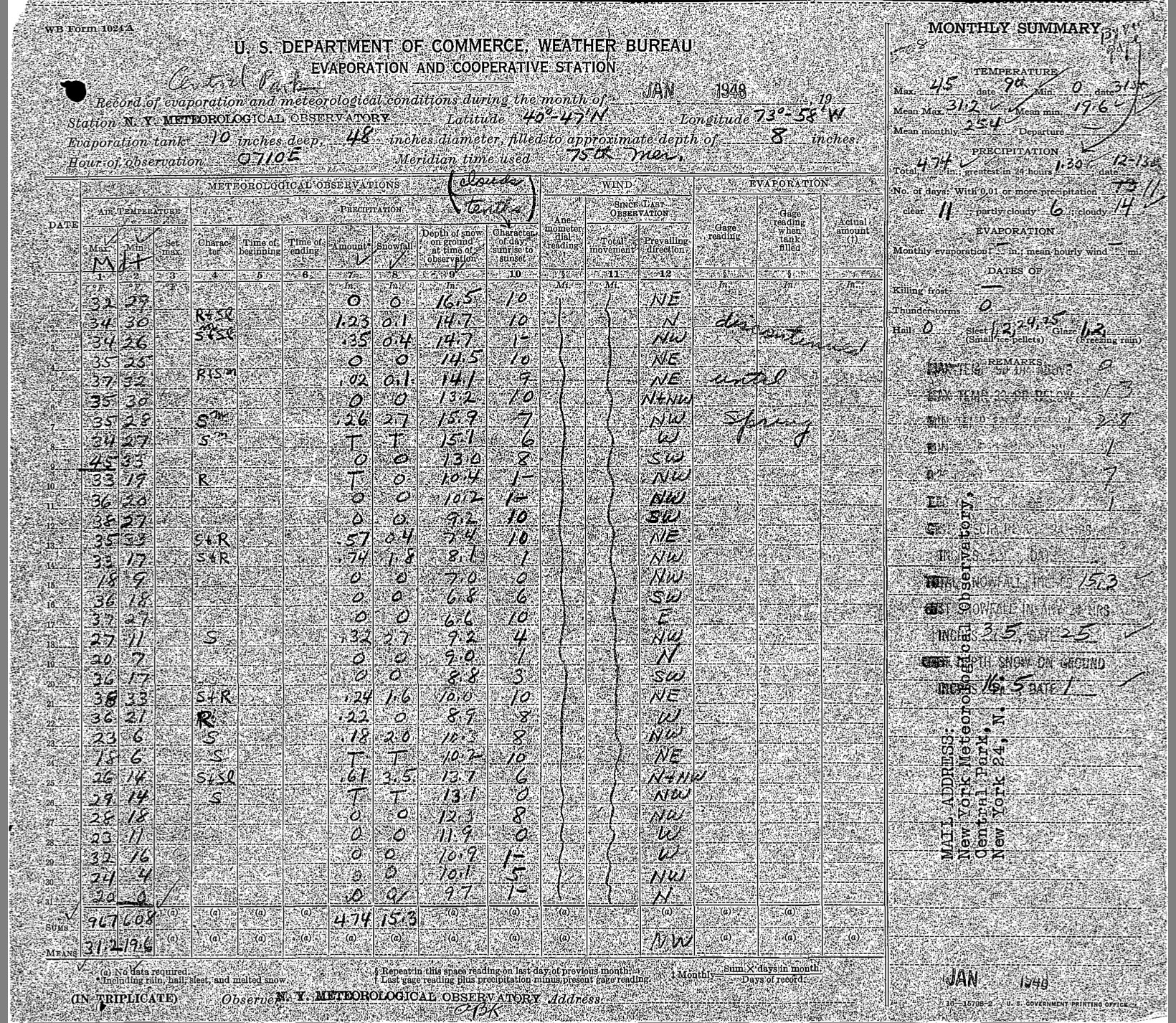
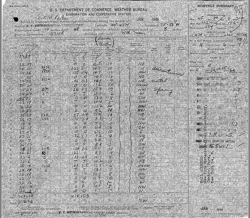
Above the max/min temp columns does that have the abbreviation Mdt? Maybe those were midnight readings and everything else was 7am and then there were supplemental midnight rain and snow obs in addition. That would imply to me that they cleared multiple times.
-
I guess that’s a possibility. You’d think they would finalize the numbers before sending it out at the end of the month. They got the liquid correct.
-
Yeah…strange that the rain totals add up to the same monthly amount but the new snow doesn’t. They do however for Jan 48.
-
Was that generated by weathergeek?
-
It’s weird. The max/mins in nowdata are the same as this. The total precipitation is the same. The snow depth is the same. But the daily precip and snow numbers are slightly different.
-
Where does the 26.4” in 1947 come from? The original COOP form has 25.8”