

michsnowfreak
-
Posts
18,382 -
Joined
-
Last visited
Content Type
Profiles
Blogs
Forums
American Weather
Media Demo
Store
Gallery
Everything posted by michsnowfreak
-

Winter 2025-26 Medium/Long Range Discussion
michsnowfreak replied to michsnowfreak's topic in Lakes/Ohio Valley
Solidly below avg temps, solidly above avg snowfall, and solidly above avg snowcover for Detroit. Been a great winter. But of course, the one thing missing is a huge storm. Im all for a March paste bomb. -
2025-2026 ENSO
michsnowfreak replied to 40/70 Benchmark's topic in Weather Forecasting and Discussion
Its way out, but I cannot see this as being a torch April. -
2025-2026 ENSO
michsnowfreak replied to 40/70 Benchmark's topic in Weather Forecasting and Discussion
Yes, everything is relative to climo. I take a 3-4 day trip to northern MI every year in mid-late February (usually the U.P., sometimes northern lower MI) and in Feb 2024 youd have thought it hadnt snowed at all the way the locals talked even though the area I was at was at like 80 inches on the season at that point. 2023-24 is my lowest snowfall since Ive kept track since 1995, at 21.4". After the gross 2023-24, 2024-25 was a good winter for MI in that it was cold and white, although snowfall was on the light side outside of the snowbelts. But 2025-26 has been a fantastic winter statewide with plentiful cold, snowfall, and snowcover. Today is the 50th day with 1"+ snowcover this season at Detroit. The depth is 8". The current 30-yr annual avg is 47 days, and the longterm avg is 49 days, so we have already eclipsed season avg in early Feb. -
Today is the 50th day with 1"+ snowcover this season at DTW. The depth is 8". The current 30-yr annual avg is 47 days, and the longterm avg is 49 days, so we have already eclipsed season avg in early Feb.
-
Yup. I live the historic old buildings. I always cringe when they tear them down. My brother that lived in Chicago for a decade always lived in old apartment buildings. He moved to Denver for 2 years before moving back to MI last year. IMO Denver had no character (too new) compared to Chicago.
-
2025-2026 ENSO
michsnowfreak replied to 40/70 Benchmark's topic in Weather Forecasting and Discussion
Its been such a steady cold winter locally, we forget that in DJF, warm anamolies are not a nail in the coffin here. In fact. If we can avoid actual torching and get an active pattern it can actually produce very well, but its of course a gamble. This would be the first time this cold season wed be in a more gambling type pattern. Its been solid cold and winter threats briefly interrupted by 2 well advertised torches. -
2025-2026 ENSO
michsnowfreak replied to 40/70 Benchmark's topic in Weather Forecasting and Discussion
I misunderstood, thinking the assertion is volcano is needed for any kind of cold anomoly winter. I feel very fortunate to live in the Great Lakes because our type of climate makes a complete winterless winter impossible. Warmer winters can see some real dynamic snowstorms ala 2022-23. A winter like the present one, 2025-26, is what I would call a classic textbook example of a harsh winter. Below avg temps, above avg snowfall and above avg snowcover. No standout storms but solid deep winter since late November with just 2 brief breaks. Today is the 21st day in a row snow has fallen. I dont ever really ever expect another 2013-14. Took this Pic this evening when dropping something off at the library.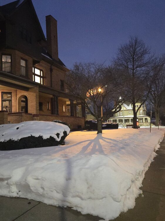
-
Nice winter night. Love this pic of the library and museum in the background.
-
Those who dont live in the Great Lakes just cant comprehend what its like to snow all the time. Just like some here complain about the east coast big dogs, my friend on Long Island gets a kick of how theres always at least mood flakes coming down here. I always tell him, bottom line, if its cold, it will snow. Now, amounts, systems, storm track etc...thats always TBD.
-
Got 1.4" of fluff here yesterday. Season to date snowfall is 36.3" imby and 35.3" at DTW. Deep winter continues.
-
Detroit finished January with a mean temp of 20.6F (-5.2F), precip 1.43” (-0.80”) and snowfall 17.1” (+3.1”). Snow depth of 1”+ covered the ground for 23 of the 31 days, peak depth 9” on multiple days.
-
2025-2026 ENSO
michsnowfreak replied to 40/70 Benchmark's topic in Weather Forecasting and Discussion
Wait...so this winter is likely going in the books as cold neutral? -
2025-2026 ENSO
michsnowfreak replied to 40/70 Benchmark's topic in Weather Forecasting and Discussion
When my brother lived in Denver, he knew going in it was going to be up and down (he loves skiing) but still it became a convenience that regardless what Denvers flavor of the day was (a snowstorm and 10° or sunny and 60°), if it wasnt snowing you could count on the cobalt blue skies and feet of powder in the mountains. And of course thst snowmelt in spring was necessary for the semi arid landscape. Knowing that its an unprecedented winter out there doesn't make me happy at all. I wish I could make it snow for you guys, just not at our expense. -
Blue sky snowblind day to start February. After a low of 2, the high of 27 felt almost mild. It was the first time we hit 20° in 10 days.
-
2025-2026 ENSO
michsnowfreak replied to 40/70 Benchmark's topic in Weather Forecasting and Discussion
March 2018/2023 redux? -
2025-2026 ENSO
michsnowfreak replied to 40/70 Benchmark's topic in Weather Forecasting and Discussion
You are always welcome to post. In fact its encouraged to get more firsthand accounts from other areas of the country. The climate in general is VERY different out West (my brother lived in Denver for 2 years, he knows firsthand). Hell its very different in the Great Lakes vs New England even though the overall winters are comparable. To be more blunt, some ridiculous "predictions" were made by a few about the inability to get cold winters in the east, and we now have 2 winters in a row colder than average. There is a lot of bias from some that clouds their otherwise reasonable judgment at times. This winter here is cold and snowy. The lake ice is thick. Wind chills are below zero daily. Its not historically noteworthy, but its a harsh winter. Most of us weather enthusiasts #1 priority is our own backyards. When we have a mild winter and you a cold one, i dont expect you to feel bad, and you are always welcome to post your obs/data/pics. Just how it works when we all share a hobby but live in different regions -
2025-2026 ENSO
michsnowfreak replied to 40/70 Benchmark's topic in Weather Forecasting and Discussion
Here come the low post troll accounts -
2025-2026 ENSO
michsnowfreak replied to 40/70 Benchmark's topic in Weather Forecasting and Discussion
They didnt. I had a good feeling about the winter here, but i certainly didnt think it would be as cold as it is. Its the perfect combo of above avg snowfall, above avg snowcover, and below avg temps in Michigan. -
2025-2026 ENSO
michsnowfreak replied to 40/70 Benchmark's topic in Weather Forecasting and Discussion
You're both missing the point that @roardog and I are making, though its not surprising as you dont seem to be longterm regular posters in this and previous years enso threads. This forum is EXTREMELY east based. So much so that roardog and I practically feel on the outskirts being in eastern Michigan. The east had been going through a stretch of mild to warm winters, with the core of the persistent warmest anomalies being the east coast. A lot of nonsense was being thrown about the inability for the east to get another cold winter, as if the 2010s were a generation ago, not a decade ago. Now this will be the 2nd colder than avg winter in a row for the eastern third of the US, with this year the coldest so far since 2014 or 2011. Nowhere did I say the cold was unprecedented, nor did I say that the west's snow drought isn't a major deal. Dig up some old threads from 2017 or 2023 when the east was mild, see if the heavy snow/cold in the west got a single mention. -
2025-2026 ENSO
michsnowfreak replied to 40/70 Benchmark's topic in Weather Forecasting and Discussion
I never knew that....and I certainly never heard that on here. But I looked it up and you are correct. The winter of 1976-77 was by far the warmest on record in Alaska. Oh, another thing that's never, ever brought up. The deep cold alaska was in during March 2012. I just can't figure out why we were never discussing those things The many, many times 2012 or 1977 have been brought up -
2025-2026 ENSO
michsnowfreak replied to 40/70 Benchmark's topic in Weather Forecasting and Discussion
The SLC snowlessness is crazy. But again. It doesn't take away from the persistent and widespread cold the east is having. Or the equally unprecedented powder snowstorms hitting the deep south. As someone who has read these boards for nearly 25 years, its incredible how during winters when the eastern US is cold, we suddenly get a massive influx of data recited from random areas never before discussed on here. Data that, of course, is anamously warm for said random areas. -
2025-2026 ENSO
michsnowfreak replied to 40/70 Benchmark's topic in Weather Forecasting and Discussion
I brought up multiple times in the past how when we have a cold winter we will be seeing tons of posts about elsewhere on the globe that is warm rather than a honing in on the same local climate data from when its a warm winter. Sure enough, im hearing about the mean temp in Kitsissorsuit before im hearing about the mean temp in NYC. -
2025-2026 ENSO
michsnowfreak replied to 40/70 Benchmark's topic in Weather Forecasting and Discussion
Exactly. Didn't we hear that we need a volcano to get a cold winter? I don't really care how warm it is in the west or elsewhere, the bottom line this is a harsh winter where a lot of us live, and i dont need to hear about other areas anymore than i hear about them when we have mild amd they have cold. Its been very common to have a warm west/cold east or vice versa pattern since records began. Obviously there are extreme winters that are exceptions, but if every winter used to be "cold everywhere" its completely disregarding the basic ridge trough alignment that is a huge factor in weather pattern. -
2025-2026 ENSO
michsnowfreak replied to 40/70 Benchmark's topic in Weather Forecasting and Discussion
Well yeah that's what many of us said all along. It was shear nonsense to assume every winter would be mild as some alluded to. -
2025-2026 ENSO
michsnowfreak replied to 40/70 Benchmark's topic in Weather Forecasting and Discussion
1000%. And not to mention, these top 5 cold anamolies are coming during what is already the dead of winter. Mid January to mid February is a time when every weekend has a winter themed festival somewhere in the area and a few of them canceled because of the cold! Canceling a winter festival because of cold lol. Locally its been the blue ribbon combination of above avg snowfall, above avg snowcover and below avg temps. Its been solid deep winter since late November with the exception of Christmas week and the 2nd week of January. While not as cold or nearly as snowy as 2014, there are multiple similarities despite the scoffing that was done by some when it was mentioned as an analog. Mountains of snowbanks everywhere, thick ice on local lakes and Great Lakes ice coverage nearly twice what it should be to date. Looking far away from here I see another winter storm hitting the deep south. This will be the 2nd winter in a row myrtle beach gets a 5" snowstorm.


