

michsnowfreak
-
Posts
18,382 -
Joined
-
Last visited
Content Type
Profiles
Blogs
Forums
American Weather
Media Demo
Store
Gallery
Everything posted by michsnowfreak
-

Winter 2025-26 Medium/Long Range Discussion
michsnowfreak replied to michsnowfreak's topic in Lakes/Ohio Valley
Boston had been in a huge snow drought. I knew it was only a matter of time before they'd cash in. They received more snow January 25/26 than they did in the winters of 2022-23 & 2023-24 combined. -
Snowdepth down to a T. Have had 62 days this season with 1"+ snowcover including 22 days with 6"+. Avg snowcover days for an entire season is 49. The snowmelt induced haze looked very eerie this morning.
-
2025-2026 ENSO
michsnowfreak replied to 40/70 Benchmark's topic in Weather Forecasting and Discussion
There is definitely some merit to the Mar/Apr correlation of warm/cool or cool/warm. Its certainly not a guarantee. But in those few years where March is warm and nearly snowless, you can bet April will see accumulating snow. -
2025-2026 ENSO
michsnowfreak replied to 40/70 Benchmark's topic in Weather Forecasting and Discussion
I just dont get into it. Been a great winter for the cold/snowcover crowd in the Great Lakes, so while most of the public is ready for a break, I hate the sun and melting snow. I am going to the U.P. later this week though. -
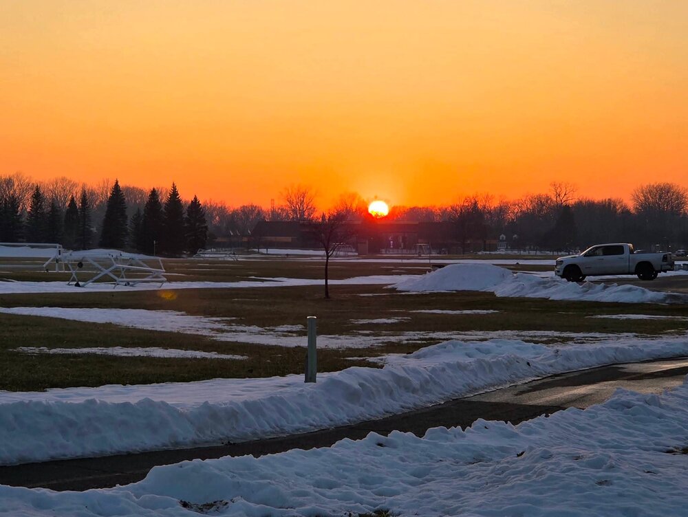
They issued because snow thats been on the ground all winter traps pollutants like road salt/exhaust/etc and its melting without aid of any wind and instead a temperature inversion, so those pollutants are hanging in the air instead of mixed out from the wind.
-
With the snowmelt indices hazy sir yesterday saw a very orange sunset.
-
Winter 2025-26 Medium/Long Range Discussion
michsnowfreak replied to michsnowfreak's topic in Lakes/Ohio Valley
This is why many Chicago weenies get annoyed with Steve's constant big dog whining acting like it never snows in SE MI when the exact opposite is true. Id be pissed too if I was sitting in Iowa or Illinois watching one snowfall after another hit Michigan with the consolation being hey, we got a 20" storm a decade ago and Detroit didn't. -
There was heavy rain at DTW for several hours.
-
Or depression. Take your pick. Signed, snow weenie
-
Even though its been an excellent snowcover winter here, i always hate watching snow melt. Id say that even if i lived where Bo does and watched the last melt in May. The snowmelt and temp inversion is actually causing poor air quality today.
-
Winter 2025-26 Medium/Long Range Discussion
michsnowfreak replied to michsnowfreak's topic in Lakes/Ohio Valley
Actually this year is the opposite here. It feels like more snow has fallen because of the consistent deep snowcover. We had a few fluff events but a lot of times it was so cold that we were getting 10-12:1 powder. The 5.2" snowstorm on Jan 25th was like sand and it was so cold, it seemed more like an 8"+ storm. Definitely due for a couple quick melting snows in Mar/Apr to complete things (and of course hopefully a big storm lol). -
Winter 2025-26 Short Range Discussion
michsnowfreak replied to SchaumburgStormer's topic in Lakes/Ohio Valley
Gradient pattern looks to be setting up for a bit for the far Northwoods. Interesting in that i was thinking/hoping for a 2007-08 esque gradient pattern during winter, but the persistent cold/NW flow had other ideas. -
2025-2026 ENSO
michsnowfreak replied to 40/70 Benchmark's topic in Weather Forecasting and Discussion
Islip NY had 19 consecutive days with with a low temp of 19° or colder, the longest stretch on record. Detroit had 27 consecutive days with a low of 17° or colder, 4th longest stretch on record. It also seems very unusual for nyc to have such consistent snowpack. Of course i dont know nyc stats like i do Detroit. Im very disappointed in the lack of stats im seeing on here for nyc from the stat crowd; I guess only warm ones count. -
Feb 9th was the last of 27 consecutive days where Detroit saw a low temp of 17° or colder. This was the 4th longest stretch on record (behind only 1918, 1948, 1936).
-
Winter 2025-26 Medium/Long Range Discussion
michsnowfreak replied to michsnowfreak's topic in Lakes/Ohio Valley
Yes it is very unusual for them. My friend on Long Island has always told me about 2 foot storms that melt in 5 days. That sounds insane to me. That would be on the ground all winter. So for them to sustain a solid pack from a ~1 foot storm (Mid-Atlantic well less than that) for weeks is very impressive for them. -
Winter 2025-26 Medium/Long Range Discussion
michsnowfreak replied to michsnowfreak's topic in Lakes/Ohio Valley
Disagree. This winter's snowpack has been far above climo in SE MI and if the pattern was shifted a bit west that could've easily been Chicago. Of course nothing compares to the record winter of 2013-14, just 12 years ago (the planet was warming then as well). Always all about the pattern. If anything Chicago's problem this winter was too much CAD. As for next winter, certainly not worried about that yet lol. With 2 colder than normal winters in a row and an el nino on deck, I wouldn't bet against a milder winter, but we've learned time and time again in recent years that enso is just one piece of the puzzle. Usually weak/mod ninos are workable. The only true nightmare scenario is if we are in mid-Fall and a strong nino is imminent. -
Winter 2025-26 Medium/Long Range Discussion
michsnowfreak replied to michsnowfreak's topic in Lakes/Ohio Valley
I would be REALLY interested to see what you would rate the winter here in Detroit. It SCREAMS Beavis winter. Outside of those 2 gross weeks (Christmas week and 2nd week of Jan) it has literally been Beavis winter to a TEE since late November. Not only has the cold and snowcover been consistent, but the snowcover was always looking fresh and clean (just now got a bit dirty after Tuesday). It was also colder in Detroit than Chicago. Not saying this in a bragging way, just because its really rare to get such a beavis winter. Ever since you explained SDDs Ive followed them closely. Chicagos annual avg since 1949 for SDDs is 176. So far this season they are at 117. Detroits annual avg for SDDs since 1949 is 183, and so far they are already at 289. So, Detroit has seen 36.3" of snow to Chicagos 32.1", yet Detroit has had 172 (and counting) more SDDs than Chicago. -
Winter 2025-26 Medium/Long Range Discussion
michsnowfreak replied to michsnowfreak's topic in Lakes/Ohio Valley
It was quite active here, just no major storms. Seemed like i was shoveling constantly at times. Here is the daily snowfall and snow depth at Detroit since Nov 29 2025-11-29 2.9 0 2025-11-30 0.7 3 2025-12-01 0.2 3 2025-12-02 0.8 4 2025-12-03 0.9 3 2025-12-04 T 4 2025-12-05 0.0 3 2025-12-06 0.0 3 2025-12-07 1.5 2 2025-12-08 0.0 4 2025-12-09 1.6 4 2025-12-10 1.4 6 2025-12-11 T 4 2025-12-12 T 4 2025-12-13 T 4 2025-12-14 T 4 2025-12-15 0.3 4 2025-12-16 0.0 4 2025-12-17 0.0 4 2025-12-18 0.0 2 2025-12-19 0.3 T 2025-12-20 0.0 T 2025-12-21 T 0 2025-12-22 T 0 2025-12-23 0.0 0 2025-12-24 0.0 0 2025-12-25 0.0 0 2025-12-26 0.0 0 2025-12-27 T 0 2025-12-28 0.0 0 2025-12-29 1.5 0 2025-12-30 0.2 1 2025-12-31 2.2 1 2026-01-01 0.5 3 2026-01-02 0.2 3 2026-01-03 0.3 3 2026-01-04 T 3 2026-01-05 T 2 2026-01-06 0.0 1 2026-01-07 0.0 0 2026-01-08 0.0 0 2026-01-09 0.0 0 2026-01-10 T 0 2026-01-11 T 0 2026-01-12 0.0 0 2026-01-13 0.0 0 2026-01-14 5.1 0 2026-01-15 1.0 6 2026-01-16 0.6 5 2026-01-17 0.2 4 2026-01-18 0.5 4 2026-01-19 0.3 4 2026-01-20 T 4 2026-01-21 2.4 5 2026-01-22 0.1 6 2026-01-23 0.2 6 2026-01-24 0.1 5 2026-01-25 4.8 6 2026-01-26 0.1 9 2026-01-27 0.3 9 2026-01-28 0.4 9 2026-01-29 T 9 2026-01-30 T 8 2026-01-31 T 8 2026-02-01 T 8 2026-02-02 1.4 7 2026-02-03 T 8 2026-02-04 T 8 2026-02-05 0.1 8 2026-02-06 0.9 8 2026-02-07 0.0 9 2026-02-08 0.0 8 2026-02-09 0.0 8 2026-02-10 0.0 8 2026-02-11 T 5 2026-02-12 T 5 -
2025-2026 ENSO
michsnowfreak replied to 40/70 Benchmark's topic in Weather Forecasting and Discussion
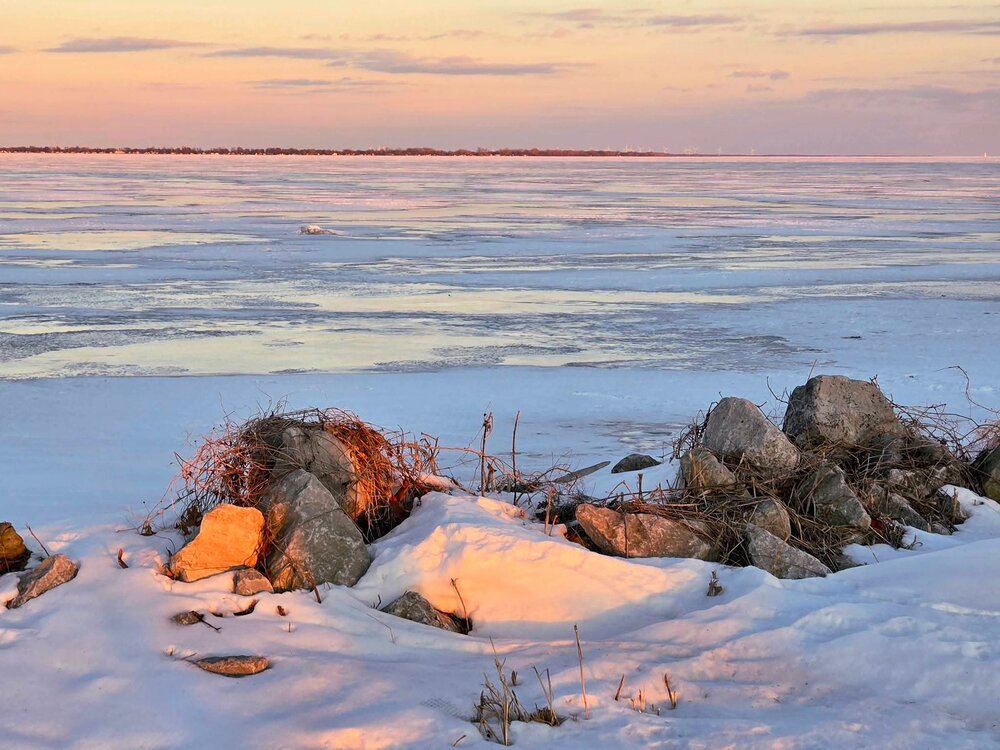
Great Lakes ice coverage peaked at 54.8% this week. After a near average winter in 2024-25, this winter ice coverage is solidly above the historical average around 40%. Superior is now half covered, with Erie nearly 100% covered. I went down to a park this afternoon where the Detroit River turns into Lake Erie. The ice is said to be 12-28" thick. Seeing an ice covered Erie is beautiful, even though that stops its Lake snow machine. https://bridgemi.com/michigan-environment-watch/ice-grips-great-lakes-with-erie-nearly-fully-covered/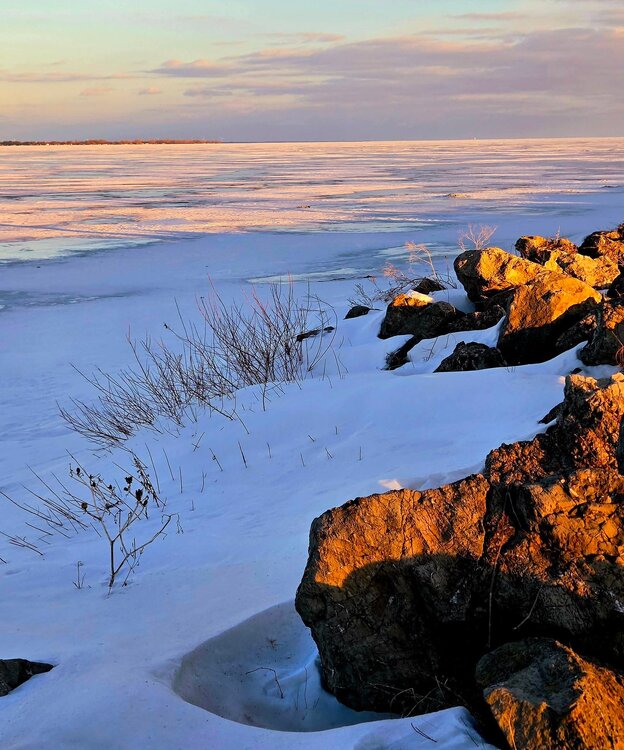
-
Went to Lake Erie Metropark late this afternoon. Frozen Lake Erie is a beautiful scene. Great Lakes ice coverage peaked at 54.8% this week. After a near average winter in 2024-25, this winter ice coverage is solidly above the historical average around 40%. Superior is now half covered, with Erie nearly 100% covered. The Erie ice is 12-28" thick near the Detroit River. https://bridgemi.com/michigan-environment-watch/ice-grips-great-lakes-with-erie-nearly-fully-covered/
-
Winter 2025-26 Medium/Long Range Discussion
michsnowfreak replied to michsnowfreak's topic in Lakes/Ohio Valley
Id bet on it. Whether its more snow, more thunderstorms/rain, or a mix, Id bet on it. Happens so often that a quiet month leads to a more active. Until this week, its actually been a very "active" winter here in SE MI, just no major storms. Two moderate ones and a ton of small ones. -
Winter 2025-26 Short Range Discussion
michsnowfreak replied to SchaumburgStormer's topic in Lakes/Ohio Valley
Me too! -
Winter 2025-26 Medium/Long Range Discussion
michsnowfreak replied to michsnowfreak's topic in Lakes/Ohio Valley
Last 2 winters colder than normal (even tho per cromartieepo last winter torched lmao). Must not be good for MKE palms. Been a pure beavis winter in Detroit. The coming pattern change is a reminder of how wild the next 2 months can be (torches, arctic blasts, snowstorms, tornados, etc). -
Winter 2025-26 Medium/Long Range Discussion
michsnowfreak replied to michsnowfreak's topic in Lakes/Ohio Valley
The mountain west hasn't had deep winter, we have. And if you think we've seen the last snow.... In fact, the average last snowfall is still 2+ months away. -
2025-2026 ENSO
michsnowfreak replied to 40/70 Benchmark's topic in Weather Forecasting and Discussion
The position of the Great Lakes - a direct path for cold shots - makes me think its very likely to see similar sustained deep cold periods like the one just passed, though not as frequent as shorter, more intense bouts as have been seen in recent years. Its really crazy to see two years in a row with deep south snow. Its been an absolutely fantastic winter for deep cold and snow/ice cover. This is two winters in a row the ratio of days with snow on the ground/snow depth to the total accumulated snowfall is greater than usual. Last winter snowfall finished below avg with snowcover around avg. This winter, while snowfall is still above avg to date, it is not as much above avg as is the snowcover. Should future winters continue to warm on avg, the opposite would likely occur (somewhat of a decrease in snowcover, while snowfall itself stats fairly steady).


