

michsnowfreak
-
Posts
18,382 -
Joined
-
Last visited
Content Type
Profiles
Blogs
Forums
American Weather
Media Demo
Store
Gallery
Everything posted by michsnowfreak
-

Winter '23-'24 Piss and Moan/Banter Thread
michsnowfreak replied to IWXwx's topic in Lakes/Ohio Valley
There's still snowcover but it's been melting. The water content of the pack has helped the melt be slow. There will still be piles but today and tonight should do it for a snowpack. A 2 week stretch of pretty deep winter is definitely not bad for a strong Nino, just hoping we do it again the 2nd half of Feb. -
Winter '23-'24 Piss and Moan/Banter Thread
michsnowfreak replied to IWXwx's topic in Lakes/Ohio Valley
Now to add some actual piss and moan banter. No matter the pattern or expectation, I HATE watching snow melt. Far more irritating to me than any model failure. -
Winter '23-'24 Piss and Moan/Banter Thread
michsnowfreak replied to IWXwx's topic in Lakes/Ohio Valley
Dont jinx either of us lol. We still need almost 9" more to avoid #20 lol. I have extensively researched both our snowiest and least snowy winters, using local newspapers as well. The "open" winters, as they called the low snow years, were just sh*t winters. Some were unreal with warmth and just terrible patterns for snow/cold (1881-82, 1889-90, 1918-19, 1948-49, 1952-53), but others had plenty of opportunities where we sat cold and dry (1936-37, 1957-58, 1960-61, 1965-66). When I say cold and dry, none of them were particularly cold winters in mean temp, but they all had plenty of times where it was cold enough and we just wouldnt snow. Detroit has not been in a snow-hole winter since 1995-96. However, this happened several times in the days of yore (see 57-58, 60-61, 65-66). In a demented way, Id even argue we were in a snow-hole-lite in 1977-78. Hard to say that in a 61.7" winter, but snowfall was greater all around us. I wish records existed from the little ice age. There are books written which have pieced together local weather from the 1780s-1860s (records began 1870s) and just like now, winters varied a great deal. But one startling thing is that there were some very cold and very dry, open winters with very little snow. (this is also documented in Minnesota, as there are journals of weather from this time). The slight warming of winters is a help, not a hindrance, to snow chances in a cold climate surrounded by lakes. (while not in a snowbelt, the amount of lake effect and lake enhanced snow has absolutely increased here the last 20 years or so). -
Winter '23-'24 Piss and Moan/Banter Thread
michsnowfreak replied to IWXwx's topic in Lakes/Ohio Valley
We can thank a slightly warmer climate for the absence of those "cold, dry" winters that happened, although infrequently, in the old days. A majority of the least snowy winters were warm, but there were several that were closer to avg or even though mild overall, had a long stretch of cold weather that didnt produce a lot of snow (1957-58, 1960-61, 1965-66 just to name a few....57-58 and 65-66 had warm decembers but cold thereafter). -
Winter '23-'24 Piss and Moan/Banter Thread
michsnowfreak replied to IWXwx's topic in Lakes/Ohio Valley
I have to check with DTX why some of those years are off pre-1900. I used the #s based on the official data (I have had it all long before xmacis existed). -
Winter '23-'24 Piss and Moan/Banter Thread
michsnowfreak replied to IWXwx's topic in Lakes/Ohio Valley
When did I ever say Toledo gets different weather patterns? I said in recent years theres been a big cutoff, larger than usual, which is 100% true. Last winter alone, Detroit had SEVERAL snowstorms that Toledo didnt get anything (or rain) from, and the same was seen in 2021-22 (to a lesser extent). Meanwhile, in 2021, Toledo area had near 20" on the ground in Feb. I never said Toledo cant score, or that Detroit cant get bad winters. But Toledo has been in a snow hole far more often than Detroit. Average snowfall is 7" or 8" less in Toledo than Detroit. Oh, and btw...if youre going to compare Detroit to Toledo, you have to start in the same year. Toledos records didnt start til 1891. So get rid of Detroits #2 and #6 least snowy winter (actually, Toledo DID have records in 1889-90, they reported just 6.0" for by far their least snowy winter, but for some reason, NWS starts records in 1891). So since 1891, Detroits #10 least snowy is 22.0", more than Toledo. Also, lets compare Detroits top 10 to Toledo's top 10: 01.) 94.9" - 2013-14 ---- 01.) 86.3" - 2013-14 02.) 93.6" - 1880-81 ---- 02.) 73.1" - 1977-78 03.) 78.0" - 1925-26 ---- 03.) 68.2" - 1981-82 04.) 74.0" - 1981-82 ---- 04.) 63.7" - 1895-96 05.) 71.7" - 2007-08 ---- 05.) 60.6" - 1966-67 06.) 69.1" - 1899-00 ---- 06.) 59.4" - 1969-70 06.) 69.1" - 2010-11 ---- 07.) 58.1" - 2007-08 08.) 67.2" - 1907-08 ---- 08.) 56.8" - 1993-94 09.) 66.5" - 1929-30 ---- 09.) 56.0" - 2004-05 10.) 65.7" - 2004-05 ---- 10.) 53.9" - 1952-53 Since 1891, # of winters in each category: Toledo ---------Detroit 80”+ - 1 -------- 1 70”-80”- 1 ----- 3 60-70” – 3 ----- 11 50-60” – 7 ----- 14 40-50” – 20 ---- 39 30-40” – 43 ---- 34 20-30” – 33 ---- 23 10-20” – 20 ---- 8 M data – 5 -
Winter '23-'24 Piss and Moan/Banter Thread
michsnowfreak replied to IWXwx's topic in Lakes/Ohio Valley
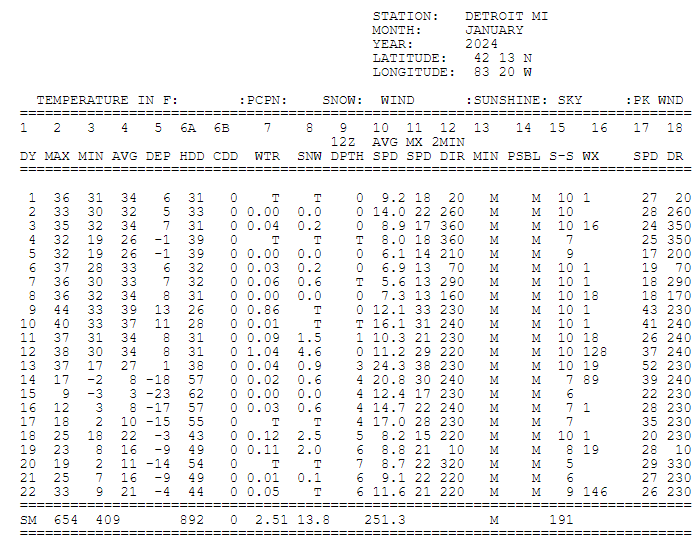
Here's the top 20 01) 12.9" - 1936-37 02) 13.2" - 1881-82 03) 13.7" - 1948-49 04) 15.2" - 1918-19 05) 15.4" - 1965-66 06) 15.8" - 1889-90 07) 16.6" - 1952-53 08) 17.1" - 1968-69 09) 18.0" - 1957-58 09) 18.0" - 1960-61 11) 20.0" - 1982-83 12) 22.0" - 1945-46 13) 22.6" - 1937-38 14) 22.8" - 1943-44 15) 23.2" - 1888-89 16) 23.4" - 1941-42 16) 23.4" - 1997-98 18) 23.7" - 1999-00 19) 24.1" - 2003-04 20) 25.1" - 1988-89 -
Winter '23-'24 Piss and Moan/Banter Thread
michsnowfreak replied to IWXwx's topic in Lakes/Ohio Valley
Judging by those pictures, I'm sure they're not strangers to meth either. -
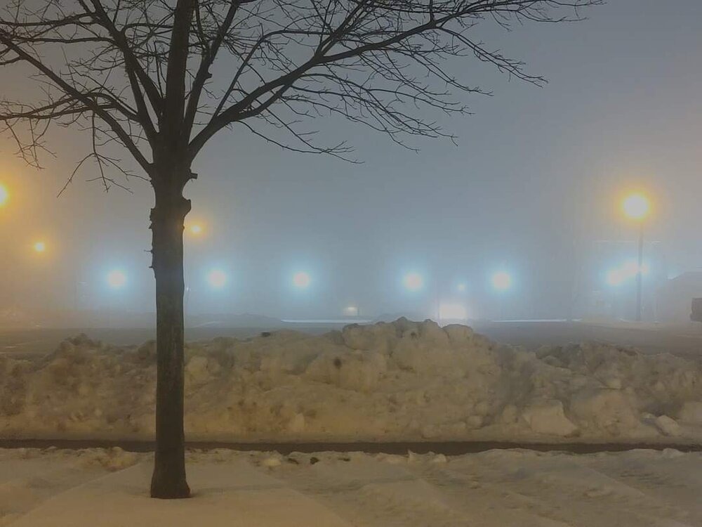
It's soupy for sure
-
I should do a post on that stretch and research some more. That's insane about 1889-90 as it was warm and snowless here. This is on my to-do list lol
-
January 22-23 Potential Ice Event
michsnowfreak replied to MazooWeather's topic in Lakes/Ohio Valley
What did I miss lol? When did you move? -
Agree on all counts. Its like inappropriate touching to the fanatics to point out cold/snow extremes. No one is denying climate change, but the Great Lakes/Midwest is a region with cold winters/hot summers, so most winters, no matter how "warm" they are in the mean, will have some cold/snow stories to be had. And quite honestly, back to the graph chinook posted, I am quite surprised what a bout of deep winter this region saw for a strong Nino. I knew we would have cold shots and snow while some were on a ledge in December, but did not foresee a blast like that. Hoping some more fun is had in Feb/Mar. So much of the season to go, but year-to-year rubber-band snaps can be wild. Locally, there were insane ones from 1880-81 to 1881-82, 1917-18 to 1918-19, and 1981-82 to 1982-83. But the 5 year period from 1877-1882 was downright wild. 1877-78: warm 1878-79: cold 1879-80: warm 1880-81: cold 1881-82: warm
-
Incredible. Each region of the country has their flaws & beautiful points, but winter in the Great Lakes is always a fun time, especially up north, but even down here in the southern Lakes. @MJO812 needs to move to a lake belt. Colder winters often see less snow in total (2013-14 was an absolute epic defy-reality type scenario of insane cold AND snow) but more snowcover and with lakes and waterways frozen you can see some incredible things (hiking ice caves on the Great Lakes is an incredible experience). Warmer winters are frustration to cold/snowcover lovers (especially here in the southern lakes) BUT the tradeoff can be more storms and more lake effect. Look what just happened with the big arctic blast, lake belts got pummelled. Now the warmth will returning, keeping ice at bay, and if the cold does materialize towards mid-Feb, they will get it again. Warm winters do create more intense storms too; since last winter I have seen thundersnow and blinding snow rates multiple times. Winter just doesnt sustain itself. On the east coast, its clearly more feast/famine to begin with and seems to be getting even more extreme. I cant imagine the frustration snowlovers in nyc are going thru, but it wasnt long ago that nyc was seeing record snowfall (2010s). The wait may be torture but warming oceans and a milder winter climate on the coast may lead to some incredible snowstorms. The famine will outweigh the feast, but when you feast, you will FEAST.
-
Yes, especially in the east. NYC it was -1.3F, BOS was -1.7F. Here at DTW it was -0.2F.
-
No way does Escanaba avg 70". I thought there was a map awhile ago from MQT. Ill have to try and find it. But obviously it goes way, WAY up north of there towards Superior.
-
Winter '23-'24 Piss and Moan/Banter Thread
michsnowfreak replied to IWXwx's topic in Lakes/Ohio Valley
Very doable for Toronto. Although far from a lock. If Detroit saw not one flake the rest of the way (impossible lol), it would be the 7th least snowy winter. To avoid top 10, just 1.8" more is needed and to avoid top 20, 8.9" more is needed. Much like this stretch of deep winter we are coming out of, should there indeed be a sharp reversal from warmth to cold as we head towards mid-Feb, that still does not sort out the haves and have nots of snowstorms until we are closer in. -
Lmao. You've got to be kidding me using that map. And actually that would be monroe county, the downriver area are 2-3 feet. That map shows Pittsburgh got like 6". Every official station in southeast michigan had 45-50" last winter except DTW 37". The fact that toledo had way less (several times we had heavy snow and they had heavy rain) means nothing. It's like saying that buffalo did not get 3 feet of snow since rochester only had 2 inches.
-
They average more strictly from Lake Erie influence. It isn't a snow hole just because its not in the snowbelt. There are actually places in the banana belt of the upper peninsula & northeast Lower peninsula of michigan that average around or slightly less know than Detroit or Pittsburgh (but more snowcover). Detroit averages 7-8" more than Toledo, but it's more extreme in warm winters, with last year being a great example. It's like the old saying, sometimes you have to smell the rain to get the best snow. That was the case last winter. Some great storms and snowfall rates but not for cold and snow cover
-
Winter '23-'24 Piss and Moan/Banter Thread
michsnowfreak replied to IWXwx's topic in Lakes/Ohio Valley
Lol no April is NOT a winter month. I just mean you usually get a little bit of snow to pad the season total, and when talking futility that season total is what we base it on. Since we've had a stretch of deep winter, now what i'm really interested in is if once this warm start to february passes, can we see a big widespread snowstorm hit the region? -
Yeah, I was just talking as a whole. I really do feel we're in for another repeat of what we just saw with a huge snap from warm to cold. The difference is this one may give more cold to the east coast and this last stretch did. I love the frigid cold and spend a lot of time in it. But I'm not gonna lie, it was absolutely brutal at times. Looking back at how warm it was in December (After halloween snow and a frigid thanksgiving weekend), if we truly do another snap to extremely warm to start February followed by a sharp reversal to cold, it will really be one of the more bizarre winters I can recall.
-
Amateur. Come up to MI and we'll show you an overcast stretch
-
Winter '23-'24 Piss and Moan/Banter Thread
michsnowfreak replied to IWXwx's topic in Lakes/Ohio Valley
In the past 2 weeks I saw 14" of snow. This is why I dont like talking futility early lol. DTW is at 16.3" on the season with just over half of the snow season statistically to go. -
That illustrates it perfectly Don, thanks! Even here on the "edge" in Detroit, we had -30F wind chills and the + departure was quickly wiped away.
-
Dude, you went bat shit crazy MELTDOWN because it was pointed out, in jest, that you didnt barge into our subforum to post the stats of the record cold week most of the middle of the country saw Jan 14-20th (or as you refer to the coldest 3rd week of Jan on record, "run of the mill" winter weather). You get so hurt when someone points out ANY cold or snow stat and start crying they dont believe climate change is real. Seriously, what is wrong with you? And how the HELL is DTW not representative of what residents of southeast Michigan experienced last winter? I dont believe for one second youve ever been here or "all over". If youve ever been, especially recently, youd notice what a huge difference there often is between Detroit and Toledo. SE MI is not in the snow belt, so obviously theres more snow in west MI. But more snow to the south? You MUST be joking. SE MI hasnt been in a snow-hole in years (1995-96 the last time I recall). We had multiple good storms last winter that Toledo & of course Pittburgh missed. Youre right though (for the wrong reason)...I guess DTWs snowfall isnt representative of what most in SE MI saw in 2022-23: Flint- 46.5"...Saginaw- 46.7"...Ann Arbor 51.6"...DTX NWS 44.7"...DTW 37.1". Im thinking when DTW had blindingly heavy snow, 6.5", on Jan 25th you missed it since PIT was 45F with snow turning to rain. Maybe you also missed when DTW got 6.2", blizzard conditions, thunder & lightning Mar 3 (when the northern burbs got 10"+) since PIT was 45F and rain. Must have also missed Mar 3 when our beautiful 5.2" was a 42F-rain in PIT.
-
Beat me to it Don. The 7-day period Jan 14-20 was one of the coldest on record for most of the middle third of the country, which is why I said midwest (and southern Canada). The east coast missed the brunt of the cold.


