

biodhokie
-
Posts
460 -
Joined
-
Last visited
Content Type
Profiles
Blogs
Forums
American Weather
Media Demo
Store
Gallery
Everything posted by biodhokie
-
Probably since its only a day or twos worth of blue balls instead of a 5 days of tracking to get blue-balled.
-
The one thing that DC does well: hot.
- 2,802 replies
-
- 1
-

-
- severe
- thunderstorms
- (and 4 more)
-
I think you move High Risk into a box of his own into the Ian/Ellinwood slot. He would be the most like them that consistently post.
- 2,802 replies
-
- 1
-
-
- severe
- thunderstorms
- (and 4 more)
-
That's not fun though. I want to expect nothing and still be disappointed.
- 2,802 replies
-
- 2
-
-

-
- severe
- thunderstorms
- (and 4 more)
-
IIRC it defaults down to the lowest person who is out. So we are currently under a code Yoda.
- 2,802 replies
-
- 2
-
-
-
- severe
- thunderstorms
- (and 4 more)
-
Red Box nearby. Mesoscale Discussion 0852 NWS Storm Prediction Center Norman OK 1202 PM CDT Tue May 28 2019 Areas affected...portions of the Mid-Atlantic into the Northeast Concerning...Severe potential...Tornado Watch likely Valid 281702Z - 281900Z Probability of Watch Issuance...95 percent SUMMARY...Storms are expected to develop this afternoon and will likely become severe. Large hail, damaging wind gusts, and a few tornadoes are possible. A tornado watch will likely be issued in the next couple of hours. DISCUSSION...A belt of enhanced mid-level westerly flow of 50-70 knots is stretching across the Great Lakes into the Mid-Atlantic/Northeast. A shortwave trough embedded within this zonal flow currently entering the Great Lakes region will move eastward throughout the day helping to provide forcing for ascent and strengthen deep layer shear. A surface low is located just east-southeast of Buffalo, NY with a warm front stretching to the southeast through northeast PA and central NJ. This warm front should lift east-northeast with the surface low forecast to track generally eastward. The Cu field is becoming increasingly agitated within the warm sector and storms are likely to develop in the next couple of hours. Storms are likely to develop across west/central PA and move east-southeast during the afternoon and evening into portions of NJ/MD/DE/southern NY. Supercell development is likely and few storms may remain discrete. Low-level veering is better to south/east across the region, but flow/shear is stronger farther to the north. Large hail is possible given forecast MLCAPE of 1500-3000 J/kg and effective bulk shear of 35-50 knots. Additionally, strong synoptic winds and steepening low-level lapse rates, especially where strong insolation occurs, will increase the severe wind threat. Tornadoes are possible as well, especially for storms that exhibit more southeast movement, which will maximize SRH per observed/forecast soundings. ..Nauslar/Thompson.. 05/28/2019 ...Please see www.spc.noaa.gov for graphic product... ATTN...WFO...OKX...PHI...BGM...AKQ...BUF...CTP...LWX...PBZ... CLE... LAT...LON 39767949 39848040 40378054 40878056 41458043 41818024 42007982 42057791 41957629 41447465 41257439 40837422 40457419 39887453 38977511 38587554 39077680 39307738 39767949
-
Curtains of rain in Bethesda, visibility down to <0.5 mi.
-
CAD finally eroding here in Bethesda. Went from 65 to 72 in the past 30 minutes.
-
I'm hoping to get some good booms. I'm desperate for a good storm.
-
Yep. RadarScope is worth the $10.
-
-
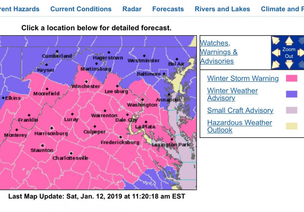
Nothing like having to work in a windowless room on a Saturday. I’m fully expecting flakes to be flying by 4 pm and it’s a winter wonderland outside. That said, how does the red line (outdoor portions) fare during snow events?
-
DCA: 11/1 BWI: 10/27 IAD: 10/31 RIC: 11/15 Tiebreaker: 2.2"
-
Devastating tornado strikes Joplin, Missouri
biodhokie replied to Hoosier's topic in Weather Forecasting and Discussion
Glad to hear the businesses are deciding to re-open. The continuing drive to normalcy is great for Joplin.
