

mahk_webstah
-
Posts
11,845 -
Joined
-
Last visited
Content Type
Profiles
Blogs
Forums
American Weather
Media Demo
Store
Gallery
Everything posted by mahk_webstah
-
 Regeneration up here to steady light snow. We’ll see if it can maintain
 -
Great for some;disappointing for others. Unsure which group I’ll fall into. NWS Weather Prediction Center College Park MD 200 PM EST Fri Jan 20 2023 Valid 12Z Mon Jan 23 2023 - 12Z Fri Jan 27 2023 ...Heavy snow threat for the interior Northeast with an exiting storm Monday... ...Second storm to spread a heavy rain/severe weather threat to the South early next week, working up the Eastern Seaboard midweek along with a heavy snow threat from the central Rockies/Plains through the interior Northeast... ...Synoptic Overview... The weather pattern will remain stormy but progressive across much of the nation going into next week with two well defined low pressure systems of interest. The first will be affecting the Northeast U.S. going through Monday and then exiting into southeast Canada by Tuesday, with coastal rain and interior snow. Meanwhile, the next closed/deep system will dig robustly over the Southwest into Monday then eject across the south-central U.S. early in next week, with a subsequent track in a general northeasterly direction across the Ohio Valley and then the Great Lakes by Wednesday and into Thursday. A building West Coast/western Canada upper ridge as a +PNA pattern will then herald a return to colder conditions from the West to across much of the central and eastern U.S. as amplified upper troughing works develops downstream.
-
Hopefully some of us will be going into that cold, active run with the foot and a half on the ground already
-
-
Latest WPC has the low at about the canal. Still plenty of qpf.
-
That same stripe keeps showing up
-
You should've done this in Gaelic.
-
very light though. I have no expectation that we get much more in terms of accumulation.
-
no change
-
I am just several miles south south west of Brian. I’m not sure what the differences between the IVT and upper level low snows. But it looks like some of the returns seem to be best south so we need to get that west south west to east north east band set up from our area to your area.
-
On radar can see the stuff backfilling around Winnepesaukee and Gene, and then the stuff rapidly filling in crossing the Vermont, New Hampshire border and heading east. Looks like there should be a pretty good wide band setting up across central and southern New Hampshire and down into southern New England. Fingers crossed that all of us, or most of us, but into smashing today.
-
Geez the heaviest swath goes literally from me to Brian to you. Have to see what the others depict.
-
Looked at WPC and GYX for next two storms. Pretty enthusiastic. They project over 2”qpf and seems to be mostly snow here. Interior for CNE and SNE have a shot. These are coastal so messenger ticks on the table.
-
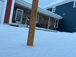
A very uniform 5” here
-
Looks like about 5 to 6 inches here. Snowing light, but quite steadily and accumulating. The Wunder ground radar shows no echoes. It isn’t that unusual to snow here with no echoes but it’s usually very light snow. Looking forward to what happens when the upper level gets closer.
-
Snowing steadily with decent flakes but no echoes
-
thank you, getting prettier as back edge fills.
-
You post another one sometimes during heavy snow, that is mostly SNE but CON is visible in the northern part of the screen. But thanks again.
-
Thank you Will! Looks like waves but the stuff in EPA and NJ needs to keep developing because that is a big gap back to the ULL. I assume the coastal should cause some blossoming.
-
can somebody post that good radar that Will and Brian sometimes post?
-
Actually snowing hard and an inch already. Moderately good snow growth, very sticky.
-
Good burst as I was driving home from dinner in Franklin. Roads caved almost immediately and temp dropped. Then opened up computer and Wunderground had cut snow totals in half. Oy! Radar unimpressive.
-
That sounds like an awesome stretch. 2 months of real winter is great, and actually having it break in February (if it gives an early spring) can be a nice bonus. Sounds like a serious pack was built.
-
I think the high is retreating, so there will be some residual damming, a strong storm will have a good thump before the midlevels overheat, then maybe a slot that ends up glazing us before Wednesday (which kinda looks good eh?). Also, who knows maybe there's a little more confluence than we see on Sunday.
-
well certainly consolation and hope for us. Brian's at work, Gene's doin whatever...just you and me keeping hope alive.

