.jpg.2573028626d558966424be2bdf9b8490.jpg)

Buckethead
-
Posts
2,724 -
Joined
-
Last visited
Content Type
Profiles
Blogs
Forums
American Weather
Media Demo
Store
Gallery
Everything posted by Buckethead
-

2020 Spring and Summer mountain thread.
Buckethead replied to Met1985's topic in Southeastern States
I have slush at 4300' and 37°. Amazing contrast from my 77° Saturday. -
2020 Spring and Summer mountain thread.
Buckethead replied to Met1985's topic in Southeastern States
Oh I'm...surviving...lol. Now I just have a good excuse for never leaving my neighborhood. Sent from my SM-G970U using Tapatalk -
Had a high of 77 on Saturday here in Wolf. The warmest summer temperature I've had since moving here three years ago is 78.7, so you could say Satuday was summer like. And now I have snow in the NWS forecast tomorrow night into Wednesday. Gotta love spring!
-
2020 Spring and Summer mountain thread.
Buckethead replied to Met1985's topic in Southeastern States
Nothing here. Just partly cloud and calm. -
2020 Spring and Summer mountain thread.
Buckethead replied to Met1985's topic in Southeastern States
Just saw that. I love it when we mix snow and tree pollen. -
2020 Spring and Summer mountain thread.
Buckethead replied to Met1985's topic in Southeastern States
This made being up early worth it today. Wish I had remembered to grab my dslr. Looking forward to a few dry and warm days this week. Sent from my SM-G970U using Tapatalk -
2020 Spring and Summer mountain thread.
Buckethead replied to Met1985's topic in Southeastern States
I guess it's that's a wrap on winter. I can't believe I'm rating 40" of snow as a bad season, but I am. Just never could get a single storm to drop more than 3". Oh well, I'm looking forward to April 4...ready for some trout! Hope everyone is doing well. If anybody needs anything, I'll do whatever I can to help ya. Just putting it out there. Sent from my SM-G970U using Tapatalk -
That's 1.5" better than I've had in any one storm this season way up here at 4400'. Nice! Sent from my SM-G970U using Tapatalk
-
I have about 3.5". Still snowing but I doubt I reach 4".
-
I'm glad to see you got something man! I've seen many winters in Gaston and St. Matthew's with less.
-
Picked up an inch in the last hour, 25/25. Sent from my SM-G970U using Tapatalk
-
Currently 26/26 with an inch on the ground and moderate snow in Wolf Laurel at 4400'. Sent from my SM-G970U using Tapatalk
-
28.2/24 with nickel sized flakes falling and a dusting on the ground in Wolf.
-
Wolf Laurel, NC elev. 4400' 31.1°/27
-
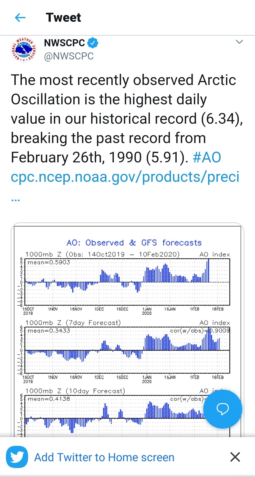
https://mobile.twitter.com/NWSCPC/status/1226866908479160323?ref_src=twsrc^tfw|twcamp^tweetembed&ref_url=https%3A%2F%2Fd-3944355110867719083.ampproject.net%2F2001281851410%2Fframe.html

-
Someone from GSP has been in here...
-
The long term disco is an absolute dumpster fire. What happened to waiting until storms get closer to the mid range before we start posting clown maps four times a day? Come on y'all, we're better than this.
-
Possible tornado in Horry County about an hour ago. Sent from my SM-G970U using Tapatalk
-
Southeast Sanitarium - A Place to Vent
Buckethead replied to Jonathan's topic in Southeastern States
Now in graph form!

-
That's a nice blue norther. I experienced a few of those living in Sherman, TX.
-
I've had over 9' of snow in the last two seasons, and according to long time residents they've both been below normal years for my neighborhood. Cool to look at but I seriously question the accuracy.
-
February into early march is prime time for anything down there I believe. I lived below Columbia for 30 years and most memorable storms (that I recall) fall into that time frame...not sure what climatology says.
-
Felt like winter today. Our high temp of 37° was at midnight, had a few flurries overnight and dropped to 23° by 7 am. Even with bright sunshine, we only rose to 30° during the day. Down to 26.7° currently.
-
Caught this hail shaft or downburst over Erwin, TN around 530 today. Looked like a hailcore on radar at that time.
-
Brad P. posted about the hurricane hunters flying through the Oklahoma storms this evening. At 6,000'. That crew has some serious cajones.