tavwtby
-
Posts
2,814 -
Joined
-
Last visited
Content Type
Profiles
Blogs
Forums
American Weather
Media Demo
Store
Gallery
Everything posted by tavwtby
-
yeah does sound trippy, but for real, waves man...
-
dude, finally someone who gets it, it's all wavelengths man, even traffic moves in waves, I've finally gotten my wife to understand this too, and reasons why we either get along with people or don't because of phase shift... anyway back to weather, wind is roaring here now, definitely looks and feels like winter out there, 25/17 with 15 sustained and a 25 gust last five minutes
-
definitely cyclical because I was looking at other data from another station further away a bit, with longer data history and prior to when the one closest began recording and the almost sinewave like pattern is present, goes up comes down, and some anomalies in between, but overall, peaks and valleys, sun activity perhaps, interesting read about the winter of 55-56, where there were like three big noreasters within two weeks, that year was the biggest here with 177", I obviously didn't take that data but that began the period of over 100" winters until like 71-72 where it tapered off some, interesting stuff
-
the 80s actually weren't that bad for this particular locale, had some decent seasons, I wasn't here of course but the obs from the station I made the list from averaged over 80" for the decade..90s were a bit more, the oughts were a bit less, then the teens were rising but lower than 90s and 80s, if that makes sense, now we're off to a crappy start to this decade... we'll see what happens next few weeks, I just want spring at this point, get to planting
-
yeah since 13-14, we've had 3 legit ratters here, I mean under 35", the first two winter here were awesome, had like 30" pack, and 8' piles, but yea, been a tough stretch
-
yeah man, have a feeling we don't see much more this season, just one of those years, need 1.5 to crack 30 here, some in the subforum got that in one shot in the blizzard, shows just how diverse the weather is in NE, more specifically SNE, such a difference for such a small distance, this I noticed really well when I moved to Winsted from Waterbury, nearly double the snowfall
-
at 28.5" on the season so at least better than 15-16...the average here since I moved from Waterbury is 63, total average since 1932 from the closest station and my obs since 2013 is just over 82, I did avg by decade and it's been going down since the 60's where the avg peaked at 118", and it steadily rose from the 30's to that peak, plot is interesting
-
I thought North ORH or north middlsex cty would jake, is that the case?
-
yeah I'm submitting in between that, 4.75 sn/ip/zr mix still have yet to get above 6" in an event this season, I think I can't remember what I got in the "blizzard"
-
this crap sucked to clean, hard to get a good measure, but I got 4.5-5" of absolute cement sleet ice garbage, blower wanted nothing to do with it either, can I get one just pure fluff snowstorm this season, jesus
-
don't think that helps anyone WOR, if it in fact even happens
-
paws and pellets...
-
about 3 here and flipping back and forth between IP and SN, AWT at the CT MA line
-

Winter storm for the 25th of February is imminent.
tavwtby replied to Typhoon Tip's topic in New England
yeah I imagine we waver here for a bit after thump -
Winter storm for the 25th of February is imminent.
tavwtby replied to Typhoon Tip's topic in New England
I don't think most people look at anything but surface, I try not to even look at them and focus on temps at all the levels of the atmosphere, fascinating stuff, I still struggle with deciphering soundings though -
Winter storm for the 25th of February is imminent.
tavwtby replied to Typhoon Tip's topic in New England
nice blotch of heavies over my head there, ha -
Winter storm for the 25th of February is imminent.
tavwtby replied to Typhoon Tip's topic in New England
funny thing is I sent an email, maybe they did, just seemed odd that all confidence around me north, east, west was for warning criteria and not here -
Winter storm for the 25th of February is imminent.
tavwtby replied to Typhoon Tip's topic in New England
-
Winter storm for the 25th of February is imminent.
tavwtby replied to Typhoon Tip's topic in New England
not sure why this won't post, but I'm now completely surrounded by warnings..ha -
Winter storm for the 25th of February is imminent.
tavwtby replied to Typhoon Tip's topic in New England
-
Winter storm for the 25th of February is imminent.
tavwtby replied to Typhoon Tip's topic in New England
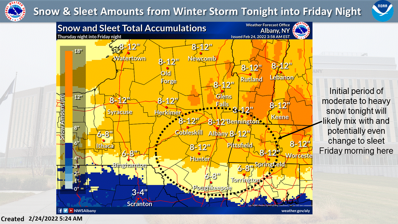
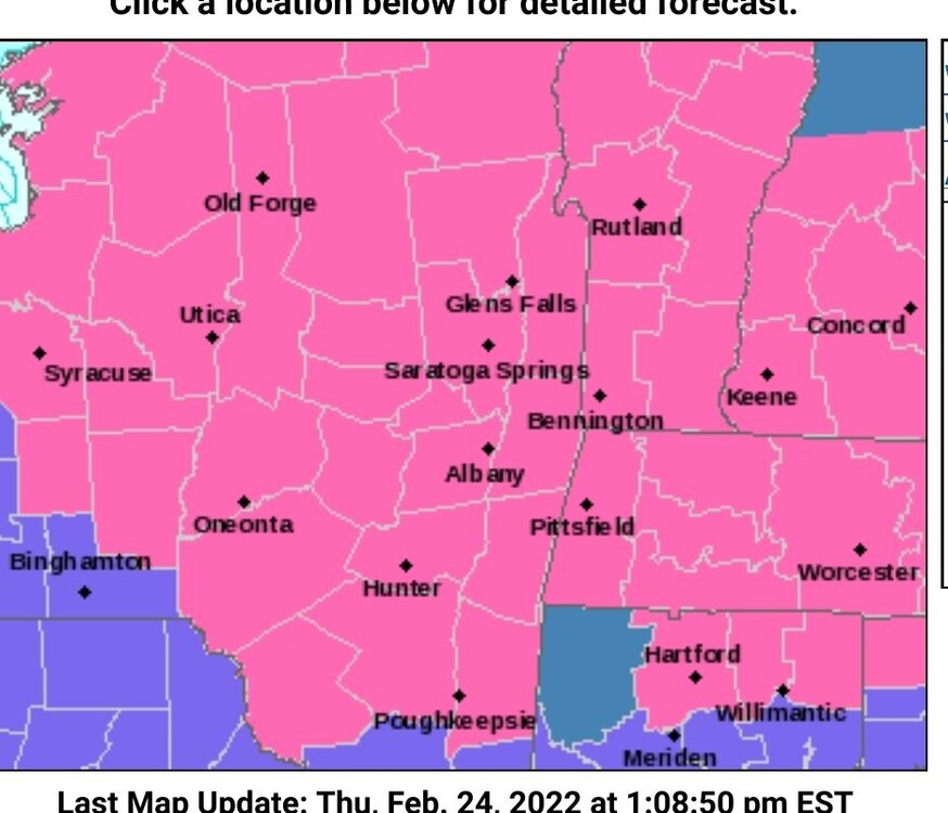
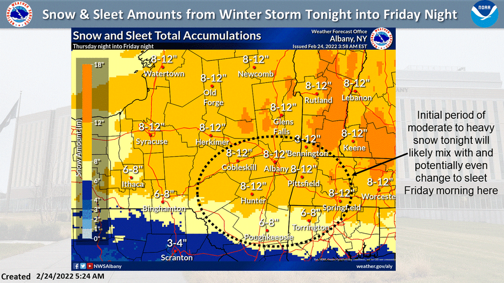
that's what I mean, we're within 24 hours, an advisory can always be upgraded, I'm surrounded by warnings and advisories, but we remain a watch? I expect the afternoon AFD will lock something in, just surprised that south of me is advisory and 5 miles to my north is warning, have to be some serious doubts for this area to not upgrade/downgrade at this time frame -
Winter storm for the 25th of February is imminent.
tavwtby replied to Typhoon Tip's topic in New England
I'm a bit perplexed that ALY has still a watch up and not at least a WWA for Litchfield cty, perhaps WSW for Northern litchfield county? -
Winter storm for the 25th of February is imminent.
tavwtby replied to Typhoon Tip's topic in New England
first call was 8-10 here, thinking that may be conservative, that 11 I spat out earlier may come to fruition, could see some very decent amounts NORH me thinks -
Winter storm for the 25th of February is imminent.
tavwtby replied to Typhoon Tip's topic in New England
again...we take, region wide event, nice -
Winter storm for the 25th of February is imminent.
tavwtby replied to Typhoon Tip's topic in New England
we take