
MANDA
-
Posts
1,296 -
Joined
-
Last visited
Content Type
Profiles
Blogs
Forums
American Weather
Media Demo
Store
Gallery
Posts posted by MANDA
-
-
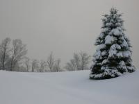
Buffalo web cams.
Looks really impressive at the moment and radar says is continues for several more hours before band shifts away from downtown.
-
 1
1
-
-
Off topic for this sub forum but -10 in Chicago this morning.
-
2
-
-
59 minutes ago, MJO812 said:
Archambault event if everything comes together like you said.
BUT....it has to break right. Overall pattern could deliver, I like it but timing s/w 's and phasing a week out is dicey.
-
2
-
-
Just now, LibertyBell said:
what happened to the people who were saying February would be our best month of the winter?
They forgot to take their meds today.

-
1
-
 1
1
-
-
3 minutes ago, bluewave said:
Highest tide on record for Portland, Maine.
Public Information Statement
National Weather Service Gray ME
1244 PM EST Sat Jan 13 2024

...New Flood of Record at the Portland Maine Tide Gauge...

At 12:06 pm...the water level at the Portland Tide gauge
registered 14.57 feet MLLW. This breaks the all time record at
this location of 14.17 feet MLLW set in 1978. Records at the
Portland gauge extend back to 1912.

Water levels will be reviewed to determine if any adjustments are
necessary to this preliminary value.
My guess the Blizzard of 78?
-
2
-
-
Looks to be locking in on a 1-3" event. Inland will see the most as ratio's will help a bit. Doubt immediate coast NJ / NYC on east see more than an inch. Could be a crap shoot if NYC gets to the elusive inch....we'll see how things evolve.
-
2
-
 1
1
-
-
Just now, bkviking said:
Someone actually drove through water and they got stuck. The police had put up the warnings but people drove through it. Gotta love it.
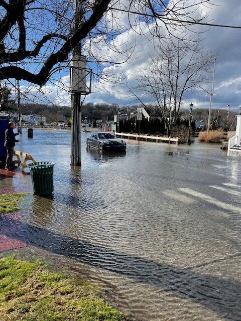
Some people are just a special kind of stupid.
-
3
-
-
Both GFS and CMC are basically showing a wave on an Arctic front. Energy too strung out. Agree with Walt and others this looks like a 1-3" event with higher than 10:1 ratios more inland locations deeper into the colder air. We'll see what EURO shows but I think we are seeing close to a final solution with GFS / CMC this morning. There will be some adjustments over the next 72 hours but the general event I think is showing some clarity this morning.
-
3
-
-
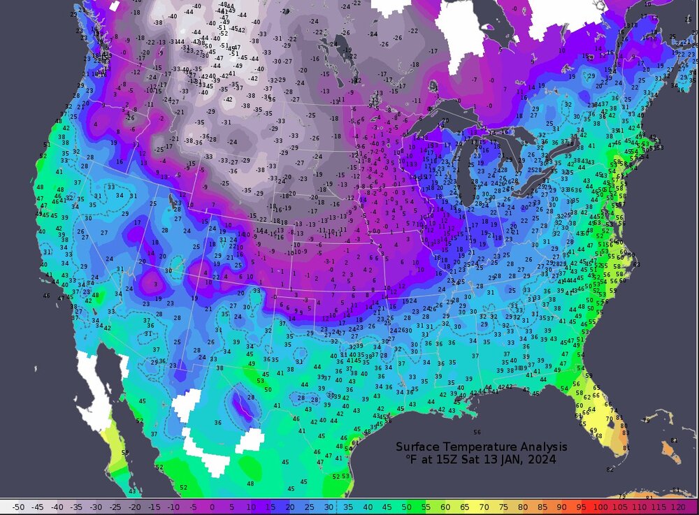
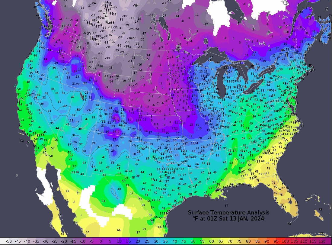
Impressive temperature map. Coldest ob. in Canada at this hour is: -55F at Keg River, Alberta.
-
1
-
-
Would like to experience that kind of cold, but just once.

-
1
-
-
The AI modeling did horrible with Lee over the summer. Several consecutive runs tried to plow a major hurricane into New England. Eventually they came around to the actual outcome that most of the op models had a few days prior. Use this AI stuff with caution.
-
1
-
-
44 minutes ago, Snowstorms said:
https://weather.gc.ca/city/pages/ab-71_metric_e.html
It's currently feeling like -72F in Edmonton. -54F tonight and -58F tomorrow night in Edmonton without windchills. This is ridiculous cold.
Remarkable really and well modeled almost a week out.
-
1
-
-
Temperatures near -50F across parts of Alberta this morning. That is First Class, Grade A cold. Something not seen every year that's for sure and certainly not in the recent past.
-
3
-
-
25 minutes ago, wdrag said:
Don,
I like stats... but these are depressing for NYC... when I keep reading these NYC stats... it's like it almost never snows in the city. I accept them as is and hoping we can expand the sample size soon.
In the meantime, not sure if anyone noticed that Don is projecting a warmer than normal Jan... but only maybe about a degree or so above. The reason that is important... the first 11 days are averaging almost +5 in CP. That means some noticeably brrrr weather is coming to getnthat average down to only +1 or so.
Will check back in the morning.
I noticed Walt and was thinking same as you. Going to be some good "offsetting" cold.
-
1
-
-
20 minutes ago, bluewave said:
I am concerned that the Euro is hanging too much energy back to the SW and it comes closer to the CMC in later runs.


That is a know bias with the EURO so definite possibility.
-
Expansive area of -30C to -40C cold across central Canada this morning. Currently -43C at Yellowknife, NWT and -46C at Old Crow,YT.
Think it is safe to say the cold has moved to our side of the pole....at least for now.
-
3
-
-
https://www.wpc.ncep.noaa.gov/discussions/pmdepd.html
No matter our outcome for snow around here a notable cold shot will be affecting the central/western states and then will be moving eastward, albeit modified.
Some record cold across the nations mid section and down to the Gulf Coast.
Any snow cover laid down in front of it will only intensify the cold, especially overnight lows.
-
18 minutes ago, ForestHillWx said:
The river was about to breach the low point of the Columbia Turnpike by the MMU airport this morning. I suspect later tonight or early tomorrow it will be closed.
That area can flood badly. Used to work weekends at ION Weather at the base of the airport tower and saw it flood several times in the early to late 90's. The area from the Cadillac dealer to Airport Road used to be impassable. Horrible detours. Usual 20 min drive would take me 60 minutes with zero traffic at 5am.
-
3
-
-
I’m rooting for my weather app!

-
5
-
-
2 minutes ago, NJwx85 said:
A lot of the river areas in Northern NJ were resort areas for people in the city during the 40's and 50's when people would vacation out in the country. That is when a lot of these areas were built up. It was a quiet period without a lot of major flooding and you could actually swim and fish in the Pompton river without fear. Then the 60's were bad with floods with 1968 being the worst. And then you had an almost 20 year quiet period until the big flood of 1984 which set records that were only broken with Irene in 2011. That's the problem. You can sometimes get a 10-20 year stretch with no issues and then a period like this happens with two major floods in less than a month and the potential for more in this pattern.
This pattern better break soon. Any more of these 1-2" rains in any kind of rapid succession is going to be a big problem for rivers across our area.
-
1
-
-
4 minutes ago, bluewave said:
Yeah, that plus retrograding blocks are one of the most difficult situations to figure out for the models.
So agree. Retrograding blocks are a big wildcard and difficult for LR/MR models to get a good handle on. I think the possibilities for next Tuesday are pretty much wide open at this point. Would not expect a hint of clarity until 12Z Saturday cycle - maybe even 00Z Sunday.
-
3
-
-
14 minutes ago, North and West said:
How did everyone do regarding power and sump pumps?
3.41" - Pump ran and did its job. Did not lose power so generator did not kick in to save the day. Pump does not run frequently here. Except for Ida rains it rarely ran in the 5 years prior. Lately has been running much more frequently.
-
1
-
-
Rainfall 3.41" here. Winds were nothing horrendous. Estimated some max gusts to 30 mph. Was expecting a little higher. Power remained on.
Ground is just saturated.
-
1
-
-
Raining heavily here at the moment.
Winds over SNJ along the Delaware Bay currently gusting to 40-50 mph.
-
1
-


Potential extensive winter event, I-95 west and with again a chance for NYC first inch(es) of snow Mon or more likely Tue Jan 16, 2024 (serves as OBS thread as well)
in New York City Metro
Posted
Where is "here"?