
MANDA
-
Posts
1,296 -
Joined
-
Last visited
Content Type
Profiles
Blogs
Forums
American Weather
Media Demo
Store
Gallery
Posts posted by MANDA
-
-
12 minutes ago, MJO812 said:
Colder I'm on board with but to use Major Snowstorm "likely"....seems a bit aggressive to me at this point.
-
12 minutes ago, TheClimateChanger said:
I'm wondering if the lack of a cryosphere will moderate any pattern change? I mean there's almost no ice anywhere on the Great Lakes - record breaking lack of ice cover. Even parts of the Upper Peninsula and arrowhead of Minnesota, which ALWAYS have tons of snow, have minimal amounts on the ground. Surely this, coupled with the high sun angle of late February scorching the bare earth, will make it tough to get any meaningful arctic air this far south and east?
Can still get very meaningful cold in February but you are 100% correct that the lack of ice on the Great Lakes + late February sun angle + possibility of bare ground upstream will certainly temper what could have been if the lakes were ice covered and some snow was on the ground. Sun angle we can't help.
-
 1
1
-
-
3 hours ago, bluewave said:
The big warm up for us comes by later next week as the block moves over to the Northeast. Then it will take a while for temperatures to get back closer to normal by mid-February.


Yep, as the block moves more east that is when the torch fires. That is when the big warm departures will make their mark on first half of February. Hopefully we can get back to around normal by the 15th. and then get colder from there. Not at all likely any cold mid and late month will wipe out the positive departures from the first half of the month. Also, unless February is unusually stormy we should finish near or below normal in the precipitation department.
-
51 minutes ago, bluewave said:
All it took was one of the strongest omega blocks on record for this time of year to finally dry things out in early February.


That is one blocked up upper air pattern. Going to take a while to get the train moving again. Going to be a real snoozer next 10-14 days, as per guidance. Then we'll see what happens. I'm pretty convinced of a period of BN temps from 2/15 - 2/20 or thereabouts. How much beyond that? Does the pattern produce for meaningful snow, 6"+ forum wide? It could but it doesn't have to. Patterns like the one that is forecast for mid / late month have failed to produce more so than not last year and this. At least something to watch with interest over the next two weeks to see how it develops. In the meantime it will give the ground a chance to dry out around here.
Be thankful the block has setup the way it did. Any further east we would really warm up, as it is we'll be in a NW flow of at least cool / chilly air with cold nights and daytime temperatures not truly torching. Any further west would have kept us in a cloudy, raw and damp pattern.
-
2
-
-
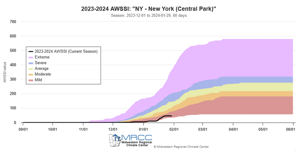
33 minutes ago, donsutherland1 said:
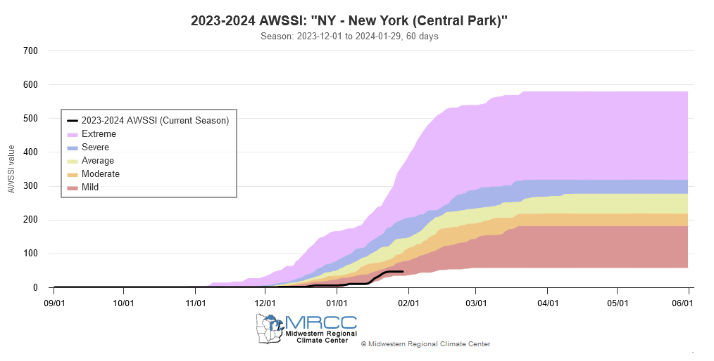
Winter 2023-2024 now ranks as the 4th worst winter in terms of warmth and lack of snowfall through January 31st:
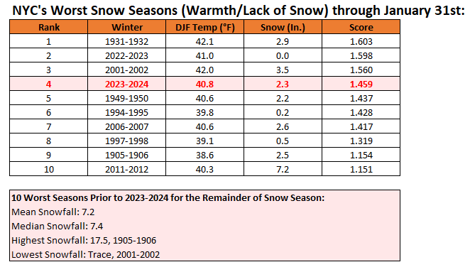
It is also categorized as a "mild" season on the Accumulated Winter Season Severity Index (AWSSI). The AWSSI is based on a more limited data set.
I suspect we'll bump up a notch or two by 2/15.
-
1
-
 1
1
-
-
.20" snowfall here overnight into this morning. Looks pretty.
Nickle and dime events and I still am not at 12" for the season.
-
Total rainfall here with this last event was 1.37". Trace of snow yesterday morning.
Majority of this rain fell with the temperatures between 33 and 35 degrees ! Frustrating to say the least.
I wasn't expecting much, maybe a half inch on colder surfaces but didn't even get that.
-
1
-
 1
1
-
-
Total rainfall here with this last event was 1.37". Trace of snow yesterday morning.
Majority of this rain fell with the temperatures between 33 and 35 degrees ! Frustrating to say the least.
I wasn't expecting much, maybe a half inch on colder surfaces but didn't even get that.
-
1
-
-
55 minutes ago, NEG NAO said:

I'll say one thing about this map. First time this season I've see a cold high in the right place with classic banana shape to funnel cold air in.
I'm not implying anything one way or the other just that I like the look of the surface map. Long way to go and I'm not getting excited about a 198 hour prog, ensemble or op.
Something to watch....that's all.
-
3
-
-
Another drenching 1"+ rainfall here. Did go to a period of wet snow between 8 and 9 am that caused the deck to get a LIGHT coating of slush and slightly whitened the pines in the yard. All gone now as it went back to rain once precip intensity decreased. Temperature 33.5 to 34.5 since about 5am.
-
3
-
-
4 minutes ago, MJO812 said:


I'll take this as an opening bid.
-
7
-
-
Gotta like the 12Z Euro. Best look so far this season even if cold air might be marginal to start. If that look or something close to it is real with the closing off upper low where it shows it then it might get interesting. Especially for the interior. I'm interested but need to see if these trends persist. You gotta like the trends this morning / afternoon though. 12Z GEFS not shabby either. Interested to see 12Z EPS shortly.
-
3
-
-
33 minutes ago, Stormlover74 said:
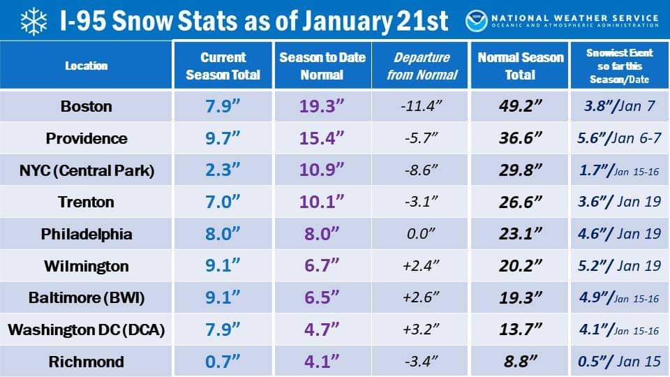
I think the Boston stat is sadder than CP.
-
10 minutes ago, MJO812 said:
We need rain
My car is a mess
And the sad thing about that is you've not got not much in the way of totals to show for it.

Out this way the roads are a mess with all the excess road salt. Like a dust storm on parts of Route 80.
So yes, wanting some rain.
-
3
-
1
-
-
Snowfall my location so far this month: 10.2". Season to date: 10.5".
-
2 minutes ago, Stormlover74 said:
Correct for philly but for nyc that's Tuesdays event. Upton never put one out for yesterday that I saw. Probably had so few reports they didn't bother
oops sorry about that. I fixed it. I hadn't looked at it before I posted the link. Thanks!
-
1
-
-
Final snow totals from PHI:
https://www.weather.gov/wrh/TextProduct?product=pnsphi
Final total here 1.2".
-
As of 5pm total 1.2". Just barely made it to the low end of my forecast range. Will get melted total tomorrow morning.
-
-
9 minutes ago, NEG NAO said:
12Z GFS thinks so one soaking rain event starting mid week after another through first week of Feb.....
At least we'll get rid of all the excessive road salt. What a mess.
-
1
-
-
-
Friend in Mt. Laurel NJ now up to 3.5" but intensity is lightening up now. He had a burst of moderate for a while with decent size flakes.
-
1
-
-
Latest snow totals from NWS PHI:
https://www.weather.gov/wrh/TextProduct?product=pnsphi
Nothing from OKX yet.
-
Can't find a traffic cam on NJDOT site that shows anything but wet roads.
State of Emergency and NJDOT Commercial Travel Ban? Was totally uncalled for. Dilutes the message when one is actually needed.
Was not THAT long ago that States of Emergency during winter storms were reserved for 12"+, blowing/drifting and heavy rates of fall so as to actually impede travel. This was never any of that.
Then they wonder why people are apathetic and don't pay attention.
-
4
-
2
-
 1
1
-


February 2024
in New York City Metro
Posted
I'll take cluster 3 for the win. Cluster 2 for the consolation prize.