
MANDA
-
Posts
1,286 -
Joined
-
Last visited
Content Type
Profiles
Blogs
Forums
American Weather
Media Demo
Store
Gallery
Posts posted by MANDA
-
-
8 minutes ago, jm1220 said:
If winter's doomed to total garbage, today will do perfectly fine. The worst is useless cold and dry to warm and the storms hit then. Sucks though for the Catskills, etc ski resorts that rely on the snow.
Totally agree. Is terrible for ski areas though as you said.
-
Helluva winter for sure!
-
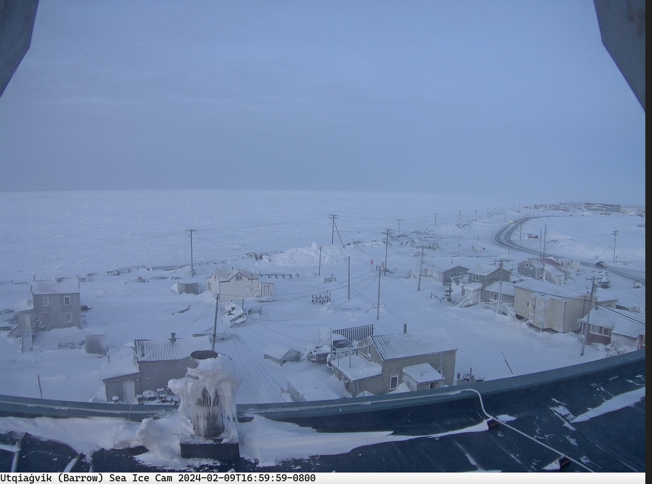
Off topic for this forum but a nice wintry scene up in Barrow this afternoon. Check out the drifting.

-
1 hour ago, donsutherland1 said:
I think the focus on a light event is warranted until there is more support for something bigger. The GFS is too aggressive. Apparently, a social media account compared the upcoming event to the February 1969 Lindsay Storm (15.3” in NYC and 20.2” at JFK). But that account didn’t tell a key part of the story: the temperature for that storm fell from 34 into the middle 20s. Most of the precipitation fell with readings that were below freezing. That’s not the case this time around. Were there a similar air mass, then we’d be looking at a significant snowfall. One other omission, the 1969 storm was much wetter than what is likely this time: NYC: 1.82” and JFK: 2.49”.
I read your post and how to go check to see if it was who I thought it was. It was. This person has really gone off the deep end last several years.
Shame.
Lindsey Storm

-
4 minutes ago, bluewave said:
Current North American snow extent at record lows for the date back to December levels.

Pathetic.
-
 1
1
-
-
53 pages on the 8th of the month and no snow or cold to show for it so far.

I know full well that is what was expected but that is a lot of "chit chat" over a pending pattern change.
Keep calm and carry on.
-
19 minutes ago, donsutherland1 said:
The two-day figure was > 1 in 1,000 years. I don't have access to UCLA's older data, but the two-day figure was a record.
Was going to guess once in a 500 year return. Wow, that is really impressive. Thanks!
-
1
-
-
12 minutes ago, donsutherland1 said:
The final storm total at UCLA was 14.20". It was an unbelievable event.
Wonder what the return period is for totals like that? Any Idea Don? Any records set with that total? Single storm? Month?
-
1 hour ago, MJO812 said:
I don't really see anyone use the snow depth map for their forecasts.
In cases like this (and for most of the events so far this season for that matter) they should be. Far better in marginal situations than 10:1 maps / Kuchera. It situations like this those 10:1 maps are pure folly and you are only setting yourself up for disappointment. To each his own I guess.
-
1
-
-
7 minutes ago, brooklynwx99 said:
my guess is that you get a vigorous wave coming onshore around the 20th, the Aleutian low retrogrades, spiking the PNA, and that's how you get clobbered. everything is in place there, TPV is perfectly elongated
No confidence in a 360 hour prog, even if ensemble. I do like the elongated TPV though. That WNW lobe from NW Hudson Bay into the NWT is ripe to come plunging southeast (and possibly phase) if the western ridge pumps. That is the way you could do something big. Like I said though 360 hours out....need this look to persist as we move forward in time. Like the look but too far out for more than passing interest from me at this point.
Plenty frigid in central and northern Canada so cold air is there to be tapped if everything were to fall into place. Would modify more than usual with bare U.S. ground and warm lakes but could turn very cold (at least 1 shot of it) if things fall into place.
-
2
-
-
17 minutes ago, NEG NAO said:
with below normal snowfall ?
Based on what I'm seeing so far I'd have to give the nod to below normal snowfall for February. Developing pattern favors keeping us on the colder side of normal for second half of the month but IMO not near cold enough to wipe out the warmth of the first half.
-
 1
1
-
-
1 hour ago, bluewave said:
It’s mostly Pacific air under the block as the weeklies don’t look very cold into late February. Near normal to slightly below normal temperatures. So February should finish with warmer than normal departures due to the warmth into mid month.
Feb 5-12
Feb 12-19

Feb 19-26

I'll bet the farm that February finishes above normal by at least 2 degrees.
-
1
-
-
1 hour ago, NEG NAO said:
What is your definition of " a decent megalopolis snowstorm this winter" ?????
12" at least...preferably 18".
-
10 hours ago, SACRUS said:
Records:
Highs:
EWR: 62 (1973)
NYC: 59 (1988)
LGA: 59 (1988)
Lows:
EWR: -2 (1961)
NYC: -3 (1881)
LGA: -1 (1961)Historical:
1870: Congressman Halbert Paine, who represented Wisconsin's Second District, introduced a joint resolution in the House of Representatives “to authorize the Secretary of War to provide for taking meteorological observations at the military stations and other points in the interior of the continent, and for giving notice on the Northern Lakes and seaboard of the approach and force of storms.” The House adopted the resolution by unanimous consent and, two days later, it passed the Senate. Five days later, on Feb. 9, President Ulysses S. Grant signed the joint resolution into law, officially creating the nation's first weather service.
1952 - The only tropical storm of record to hit the U.S. in February moved out of the Gulf of Mexico and across southern Florida. It produced 60 mph winds, and two to four inches of rain. (2nd-3rd) (The Weather Channel)
1952: An area of low pressure moved out of the Gulf of Mexico and across southern Florida during the evening and late-night hours on February 2, 1952. It produced 60 mph winds and two to four inches of rain on February 2 and 3. The low pressure remains the only tropical storm to impact the United States in February.
1956 - A record snowstorm in New Mexico and west Texas began on Ground Hog's Day. The storm produced 15 inches of snow at Roswell NM, and up to 33 inches in the Texas Panhandle. (David Ludlum)
1987 - A fast moving arctic front brought snow and high winds to the north central U.S. Winds gusted to 69 mph at Brookings SD. Big Falls MN reported nine inches of snow. Record warmth was reported just ahead of the front. Burlington IA reported a record high of 59 degrees. (The National Weather Summary) (Storm Data)
1988 - A dying low pressure system over southern California deluged the San Diego coastal mountains with more than four inches of rain causing half a million dollars damage. Arctic air invading the north central U.S. sent the mercury plunging to 38 degrees below zero at Park Rapids MN. Raleigh NC reported a record high of 75 degrees. (The National Weather Summary) (Storm Data)
1989 - Bitter cold air covered much of the central U.S. Butte MT reported a wind chill reading of 91 degrees below zero, Salt Lake City UT was blanketed with 11.9 inches of snow in 24 hours, and winds around Reno NV gusted to 80 mph. Unseasonably warm weather continued in the southeastern U.S. Twenty-eight cities reported record high temperatures for the date, including Wilmington NC with a reading of 80 degrees. (The National Weather Summary) (Storm Data)
1990 - Thunderstorms developing ahead of a cold front produced severe weather in the Lower Mississippi Valley during the late afternoon and evening hours. One person was injured in a tornado near Reidheimer LA. Thunderstorms northeast of Brandon MS produced hail three inches in diameter along with high winds which downed or snapped off one hundred trees. (The National Weather Summary) (Storm Data)
1996 - An Arctic outbreak that lasted from late January through early February produced nearly 400 hundred record lows, 15 all-time low readings, and over 50 new record lows. Four states recorded their all-time record low temperatures, including Tower, Minnesota, on this date with a reading of 60 degrees below zero, canceling Tower's annual Icebox Days festival because it is too cold. Locations that reported their all-time record low or tied included: Cresco, IA: -36�, Osage, IA: -34�, Charles City, IA tied their record low with -32� and Lancaster, WI tied their all-time record low with -31�. International Falls, MN, and Glasgow, MT set records for February with -45� and -38�, respectively. The temperature at Embarrass, MN, plummeted to -53�. Rochester, MN, dipped to -34� for its coldest temperature in 45 years. Green Bay, WI only reached -16� for the high temperature for the day, their coldest
1996: An Arctic outbreak that lasted from late January through early February produced nearly 400 hundred record lows, 15 all-time low readings, and over 50 new record lows. Four states recorded their all-time record low temperatures, including Tower, Minnesota, on this date with a reading of 60 degrees below zero, canceling Tower's annual Icebox Days festival because it is too cold. Locations that reported their all-time record low or tied included: Cresco, IA: -36°, Osage, IA: -34°, Charles City, IA tied their record low with -32° and Lancaster, WI tied their all-time record low with -31°. International Falls, MN, and Glasgow, MT set records for February with -45° and -38°, respectively. The temperature at Embarrass, MN, plummeted to -53°. Rochester, MN, dipped to -34° for its coldest temperature in 45 years. Green Bay, WI only reached -16° for the high temperature for the day, their coldest high temperature on record in February. The place to be this day was in Orlando, FL, where it was a balmy 85 degrees.
2006 - New Orleans is struck by two tornadoes, collapsing at least one previously damaged house and battering Louis Armstrong International Airport. The Weather Doctor
2008 - Hilo, HI, is deluged by 10.82 inches of rain in a period of 24 hours, breaking the previous record set in 1969 by 3.5 inches. The Weather Doctor
2011 - A high temperature of 44°F registered at Sky Harbor Airport in Phoenix, AZ, sets an all-time February record for the coldest high temperature for the city. The Weather Doctor
Imagine if we had an outbreak like that one in 1996 today! Climate doing what climate does....changing always.
-
1
-
-
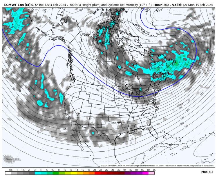
9 minutes ago, donsutherland1 said:
It should be noted that a national shift does not mean an Eastern U.S. shift. Here are the clusters at 360 hours:
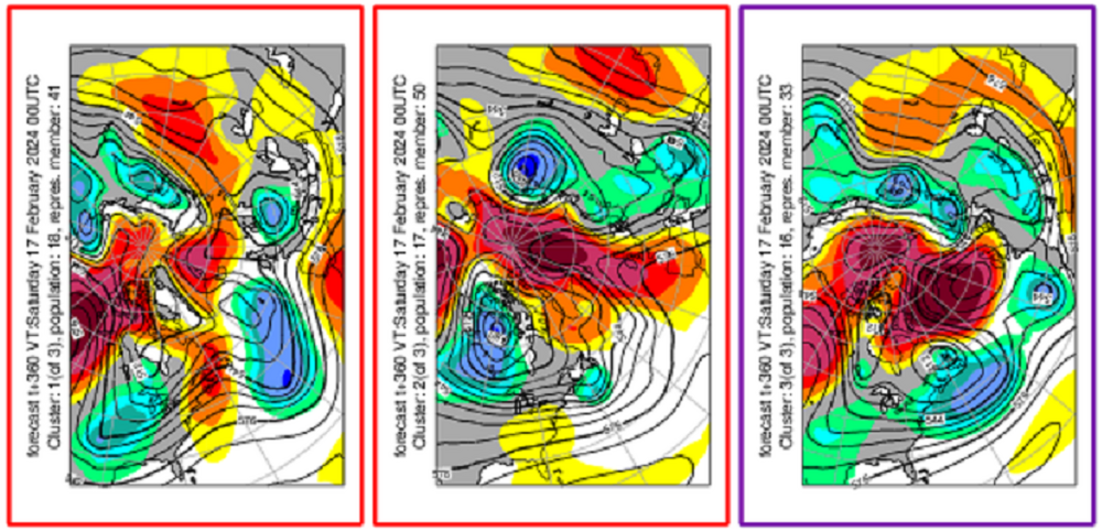
I continue to expect that a shift to colder weather will occur in the Northeast near mid-month. The 12z GFS is an outlier at the end of its range and not supported by the GEFS.
I'll take cluster 3 for the win. Cluster 2 for the consolation prize.
-
1
-
-
12 minutes ago, MJO812 said:
Colder I'm on board with but to use Major Snowstorm "likely"....seems a bit aggressive to me at this point.
-
12 minutes ago, TheClimateChanger said:
I'm wondering if the lack of a cryosphere will moderate any pattern change? I mean there's almost no ice anywhere on the Great Lakes - record breaking lack of ice cover. Even parts of the Upper Peninsula and arrowhead of Minnesota, which ALWAYS have tons of snow, have minimal amounts on the ground. Surely this, coupled with the high sun angle of late February scorching the bare earth, will make it tough to get any meaningful arctic air this far south and east?
Can still get very meaningful cold in February but you are 100% correct that the lack of ice on the Great Lakes + late February sun angle + possibility of bare ground upstream will certainly temper what could have been if the lakes were ice covered and some snow was on the ground. Sun angle we can't help.
-
1
-
-
3 hours ago, bluewave said:
The big warm up for us comes by later next week as the block moves over to the Northeast. Then it will take a while for temperatures to get back closer to normal by mid-February.


Yep, as the block moves more east that is when the torch fires. That is when the big warm departures will make their mark on first half of February. Hopefully we can get back to around normal by the 15th. and then get colder from there. Not at all likely any cold mid and late month will wipe out the positive departures from the first half of the month. Also, unless February is unusually stormy we should finish near or below normal in the precipitation department.
-
51 minutes ago, bluewave said:
All it took was one of the strongest omega blocks on record for this time of year to finally dry things out in early February.


That is one blocked up upper air pattern. Going to take a while to get the train moving again. Going to be a real snoozer next 10-14 days, as per guidance. Then we'll see what happens. I'm pretty convinced of a period of BN temps from 2/15 - 2/20 or thereabouts. How much beyond that? Does the pattern produce for meaningful snow, 6"+ forum wide? It could but it doesn't have to. Patterns like the one that is forecast for mid / late month have failed to produce more so than not last year and this. At least something to watch with interest over the next two weeks to see how it develops. In the meantime it will give the ground a chance to dry out around here.
Be thankful the block has setup the way it did. Any further east we would really warm up, as it is we'll be in a NW flow of at least cool / chilly air with cold nights and daytime temperatures not truly torching. Any further west would have kept us in a cloudy, raw and damp pattern.
-
2
-
-
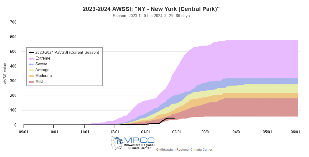
33 minutes ago, donsutherland1 said:
Winter 2023-2024 now ranks as the 4th worst winter in terms of warmth and lack of snowfall through January 31st:
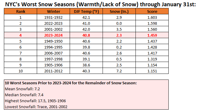
It is also categorized as a "mild" season on the Accumulated Winter Season Severity Index (AWSSI). The AWSSI is based on a more limited data set.
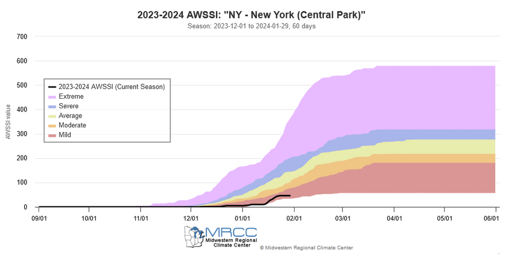
I suspect we'll bump up a notch or two by 2/15.
-
1
-
1
-
-
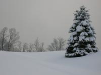
.20" snowfall here overnight into this morning. Looks pretty.
Nickle and dime events and I still am not at 12" for the season.
-
Total rainfall here with this last event was 1.37". Trace of snow yesterday morning.
Majority of this rain fell with the temperatures between 33 and 35 degrees ! Frustrating to say the least.
I wasn't expecting much, maybe a half inch on colder surfaces but didn't even get that.
-
1
-
 1
1
-
-
Total rainfall here with this last event was 1.37". Trace of snow yesterday morning.
Majority of this rain fell with the temperatures between 33 and 35 degrees ! Frustrating to say the least.
I wasn't expecting much, maybe a half inch on colder surfaces but didn't even get that.
-
1
-
-
55 minutes ago, NEG NAO said:

I'll say one thing about this map. First time this season I've see a cold high in the right place with classic banana shape to funnel cold air in.
I'm not implying anything one way or the other just that I like the look of the surface map. Long way to go and I'm not getting excited about a 198 hour prog, ensemble or op.
Something to watch....that's all.
-
3
-


2/13 Significant/Major Winter Storm Discussion & Observations
in New York City Metro
Posted