

MANDA
-
Posts
2,950 -
Joined
-
Last visited
Content Type
Profiles
Blogs
Forums
American Weather
Media Demo
Store
Gallery
Posts posted by MANDA
-
-
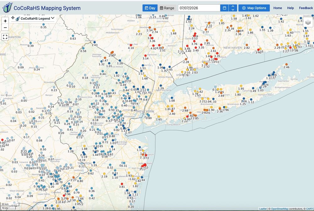
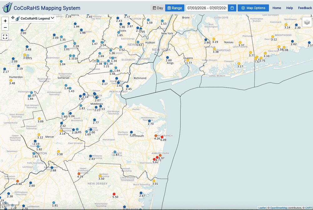
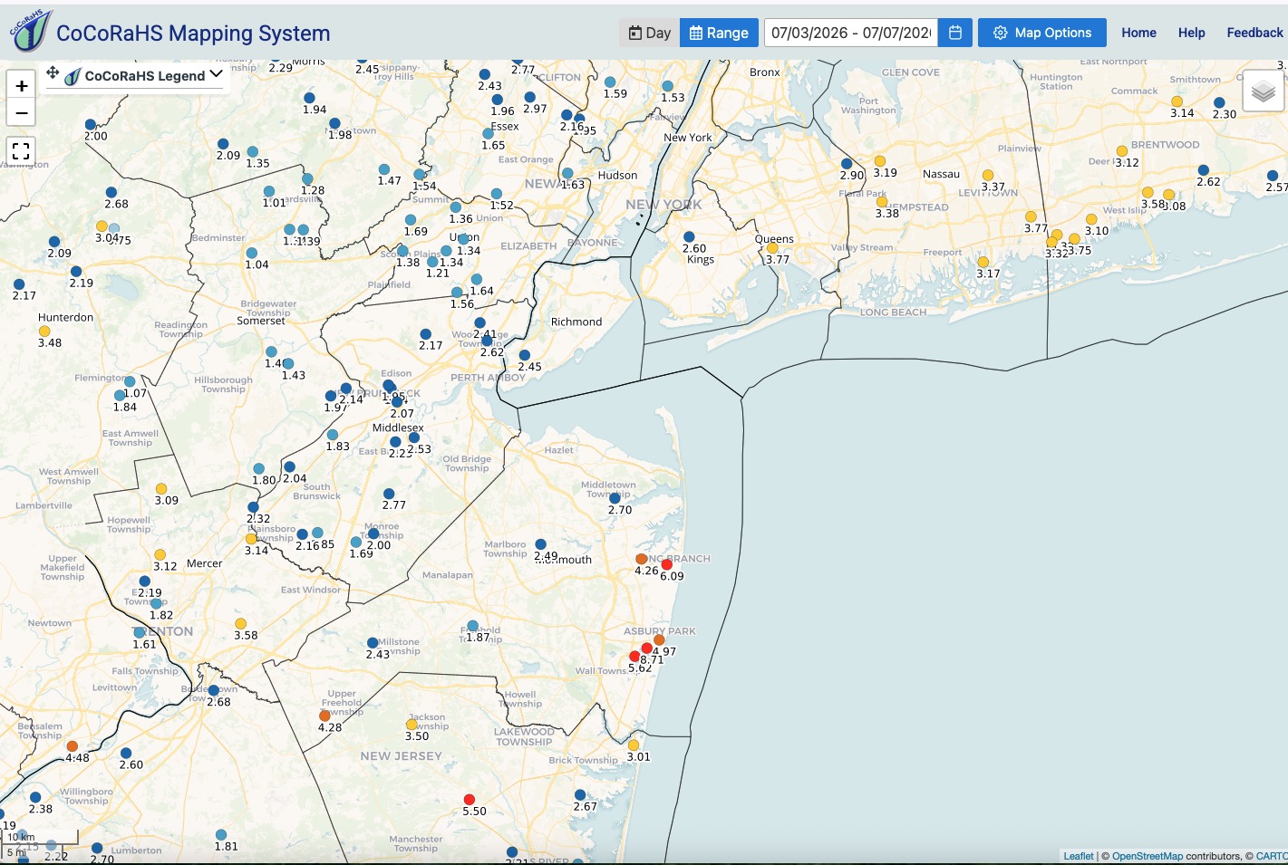
Received just .26" here yesterday.
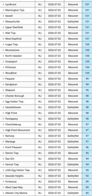
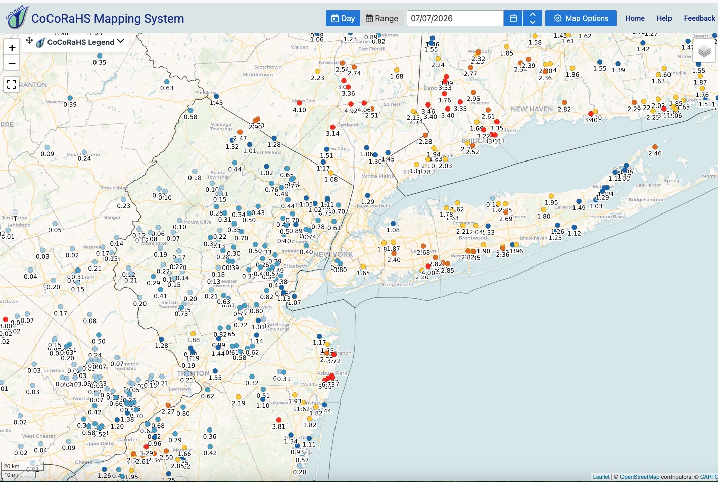
Rainfall maps: Yesterday and since Friday - click to enlarge.
Everyone across this subform got a good soaking. Localized places too much.
Everything has greened up nicely for early July. Won't have to water anything this week.
As we move deeper into hurricane season I'm interested to see how it evolves. Hostile as it gets looking ahead the next 2-3 weeks based on any parameter you want to look at.

-
 4
4
-
-
4 minutes ago, psv88 said:
Nobody was hurt so they’ll be fine.
I'd make a hefty wager someone files a lawsuit and I'd wager if they do a settlement is reached. Emotional trauma or something along those lines.
-
1
-
-
14 minutes ago, Brian5671 said:
The good news for most was that it was spread out over 24 hrs which mitigated flood risks
I think the only exception to that was parts of Monmouth County, NJ and some locations on Staten Island and along the South shore. Certainly the northern locations with 5-7" it was spread out to avoid any flash flooding.
Gotta believe BJ's is going to have lawsuits for not maintaining their rooftop drains. Litigious society and all.
-
1
-
-
41 minutes ago, bluewave said:
Multiple crews are responding to a roof collapse at a BJ’s Wholesale Club in Ocean Township.
The Monmouth County Sheriff’s Office said first responders are on scene at the store on Route 35 in the Oakhurst section of Ocean Township. Officials are asking people to stay clear of the area so emergency crews can respond safely. The collapse happened around 11:30 a.m. Multiple mutual aid crews from surrounding towns were also called to the scene.
Law enforcement officials told News 12 that there were no injuries reported. Police said all 27 staff members who were in the building at the time are accounted for and safe. All of the customers who were in BJ's at the time of the collapse are also safe, police said.According to Ocean Township Police Chief Michael Sorrentino and Monmouth County Sheriff Shaun Golden, approximately 20% of the rear of the building has collapsed. Officials believe the damage was caused by the weight of the water from the heavy rain that fell.
Authorities are also urging drivers to avoid Route 35 because of severe flooding in the area.
This remains a developing story.Governor Sherrill....Bueller, Bueller.
First the power outages and now flooding. Crickets. Could probably use a State of Emergency in a few counties about now.
-
1
-
-
2 hours ago, BoulderWX said:
A little over an inch - power still out
Mine came back about 11:30 this morning. Hope you get it soon. Friend out it Pittstown still out with estimate still Wednesday evening.
-
1
-
-
Still no power.
Rainfall total as of 7:00 a.m. a beneficial and manageable 1.36". Thankfully the excessive totals did not pan out over a large area. Isolated excessive amounts only. @IrishRob17seems to have jack potted. Threat of Flash Flooding much reduced for rest of today but still some locally heavier showers around. Temperatures down but humidity is sky high. Very soupy out there this morning.
-
1
-
 1
1
-
-
29 minutes ago, IrishRob17 said:
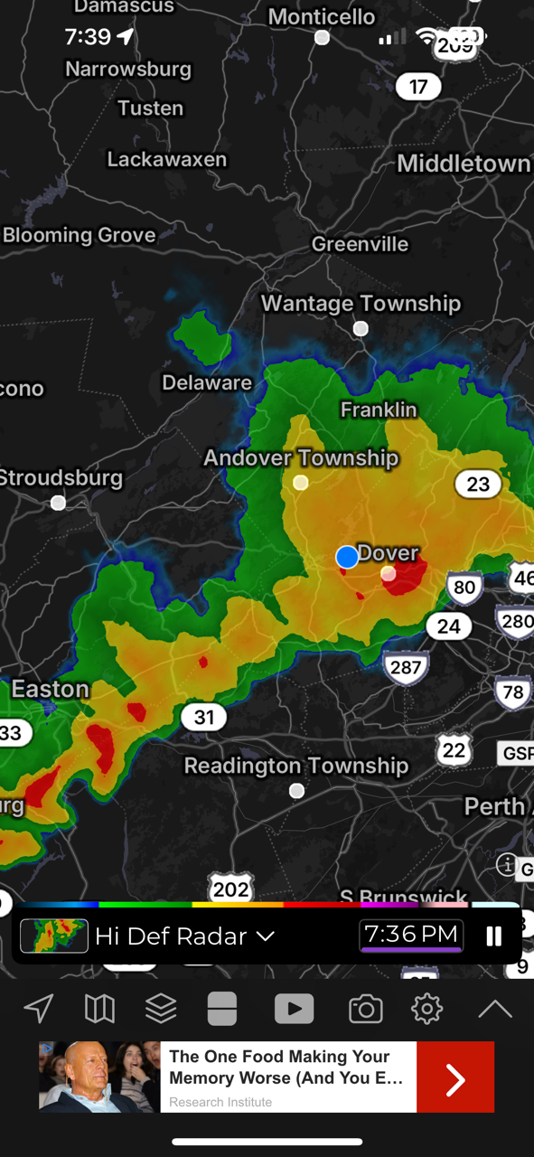
WPC discussion on the heavy rain developing and the potential flooding:
https://www.wpc.ncep.noaa.gov/metwatch/metwatch_mpd_multi.php?md=0612&yr=2026
Pretty strongly worded. Some places could be in trouble along that stalled boundary.
-
1
-
 1
1
-
-
1 hour ago, BoulderWX said:
Latest guidance on power is Wednesday night. What a horrible weekend
Same here, power still out. Latest update is 11:00 tomorrow night for my area. Generator is saving the day but honestly I'm getting tired of hearing the noise. First world problem I know.
Can't wait for the next time a Cat. 1 takes the right track. How the hell are they ever going to handle that? I know they are working hard and I'm not near as bad off as some but it seems to be taking so long. Friend in western Hunterdon County is Wednesday night and friend in Berkeley Heights is 9:00 Thursday night.
I've got nothing to complain about so forgive me. I'm just cranky.
I hope anyone that depends on a sump pump during heavy rain and is without power gets it back in time.
-
1
-
-
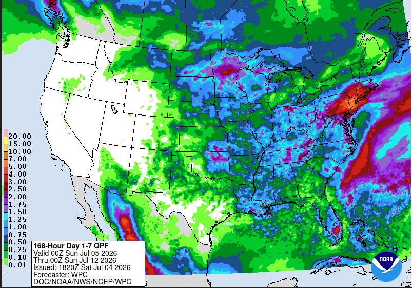
5 minutes ago, SnoSki14 said:
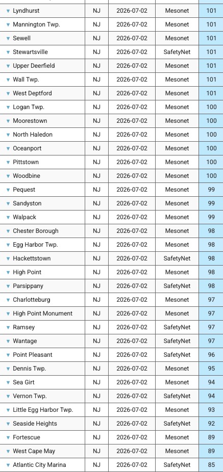
Is that accurate. That's 10"+ in central NJ over the next 2 days
Seems overdone but going to be some local 5” totals in spots I think. How bad any flooding might be will depend on rainfall rates / training.
-
First storm of the evening just slid by to my north. Gusty downdraft and some sprinkles. Few rumbles of thunder as well. Mid Hudson Valley getting rocked at this hour.
-
WPC going with the wetter guidance.
Local 5" amounts verbatim over the next 7 days with most of that from later Sunday into Monday.
Local flash flooding possible despite the ongoing dryness.
-
2
-
1
-
-
9 minutes ago, BoulderWX said:
My updated time is 6pm tomorrow - good luck man.
You as well! Not fun especially over a holiday weekend.
-
2
-
-
Power still out here. Finally received an update with expected restoration time of 7am tomorrow and crew has been dispatched. Anything severe later could delay restoration. Thankfully generator is humming away. Took 6 years but it finally paid for itself! Got it installed after Isaias in 2020. It was a 'WWI" purchase...wife wanted it. No way I was going to get away with putting it off any longer. Not after Sandy, Irene and numerous other snow / ice related outages over the years. She was having no part of it anymore.
Cell service has been spotty at best. Internet was down but just came back. Have not been out but talked with people who have been and lots of trees and wires down.
Picked up .71" rainfall in about 12 minutes with the storm last night.
Happy 4th to all. Hopefully for those without power it will be restored sooner rather than later. I think several days for total restoration.
-
7
-
-
12 minutes ago, BoulderWX said:
Got the same, good times.
Reading between the lines I think it means they are doing little or nothing until daybreak.
-
Just got update from JCPL. For my area "estimated restoration times will not be available until tomorrow afternoon"
This is not going to be a quick fix.
-
1
-
2
-
-
51 minutes ago, Picard said:
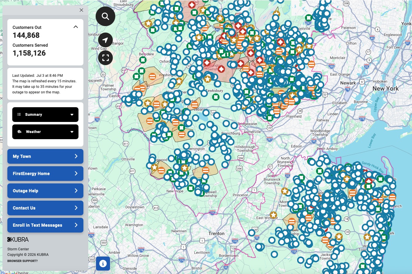
That is one hell of a map. I would expect problems on a night like tonight, but JCP&L has the worst record of keeping lights on. They are always the highest outages measured by percentage of their total customers.
Not sure what happened in my area. My power went out before the winds really hit. We had a CTG strike, a boom of thunder and off went the power. Then the winds really picked up. Lighting must have hit something. Grid was probably pushed to the limit already with the heat.
-
1
-
-
-
28 minutes ago, nycsnow said:
28k without power now
JCPL outage map is lit up. Going to be a long time for full restoration on a holiday weekend I think. Could be days for some? My town seems to be leading the way with 95% of the power out. Chester area also up there with close to 80% out.
-
 1
1
-
1
-
-
Might take a while to get the power back on over a holiday weekend. Thankful for the generator.
-
1
-
-
Temp fell like a rock. Currently 64 degrees.
-
1
-
-
Getting rocked here. Legit scary. CTG lightning and crashing thunder. Torrential rains. Winds gusting to est 60 mph. Debris all over. Power out. Generator on.

-
1
-
1
-
-
You gotta feel for people who have to work outside in this. Just horrible.
Especially in highly urbanized areas (EWR, NYC PHL etc.) with the heat coming off the pavement and buildings. Also for those with no a/c. Just stifling outside overnight. Can't imagine no a/c. Yet people did it back in the day but I just can't imagine how miserable that must have been.
Guidance suggesting some widespread rainfall later Sunday / Monday.
-
2
-
 1
1
-
-
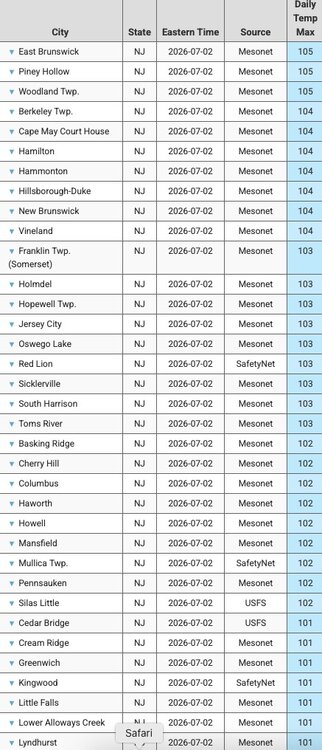
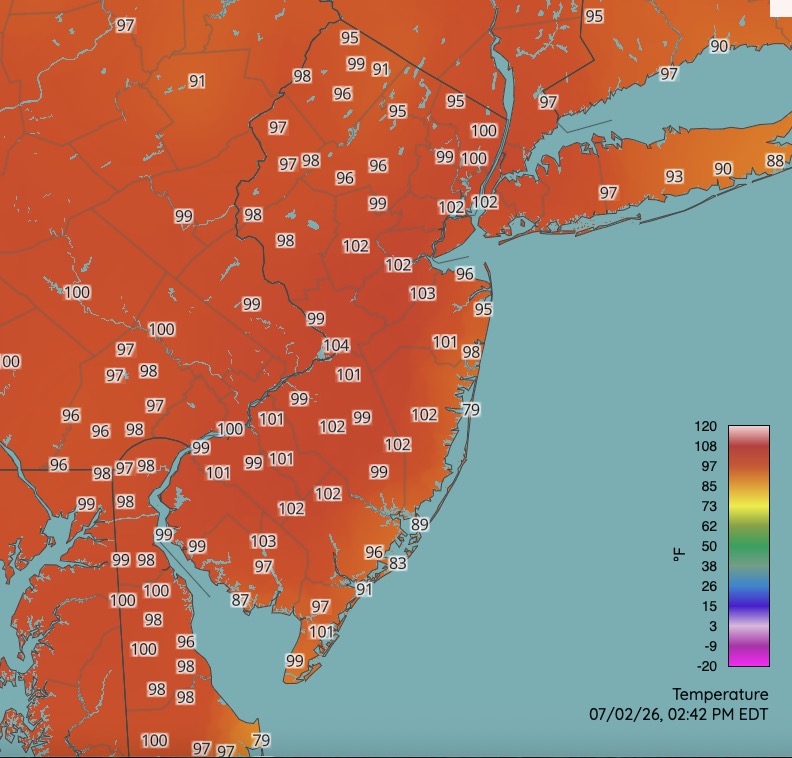
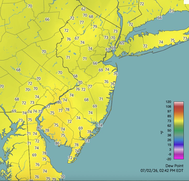
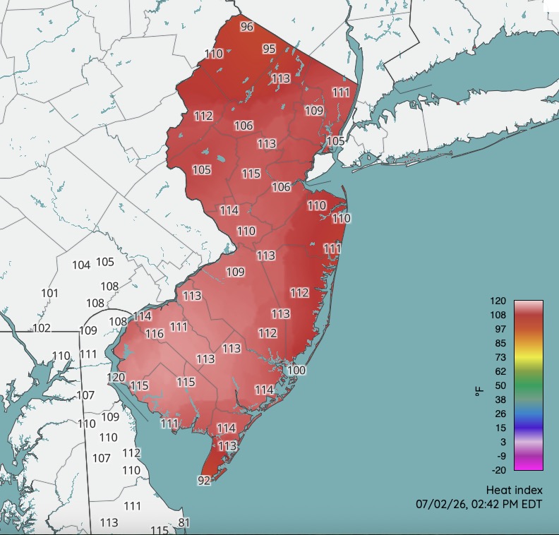
High temperatures across NJ today from Rutgers Weather Network. Most max heat index readings were between 108-115. There were some readings in excess of 115 over parts of NJ. Even as high as 120 over the southwest corner of the state. Hot day! One more similar day tomorrow. Still hot Saturday but "less hot".
-
2
-
-
Currently 97 here. That might do it for me for a high. Been going between 96 and 97.


July 2026
in New York City Metro
Posted
Socked in here all day. Even some mist / drizzle at times earlier. Temperature never got out of the 60's. High on the day 69.