
MANDA
-
Posts
1,286 -
Joined
-
Last visited
Content Type
Profiles
Blogs
Forums
American Weather
Media Demo
Store
Gallery
Posts posted by MANDA
-
-
19 minutes ago, SnoSki14 said:
Not for us. Low is too far inland
Yeah, 99% of this sub forum would have switched to rain and or sleet even with the coldest of air masses in places. Mainly because of 850's would have failed for more inland locations and sfc on up would have failed closer to coast with onshore e to e.s.e. flow. At this point who cares anyway.
-
 2
2
-
-
24 minutes ago, ag3 said:
Hrrr and short range models have this ending faster than modeled. By 3-5 pm.
Matches radar, IMO.
Agreed. Will be a soaker between now and then though.
-
Aside from a brief cool down over the weekend and into next week (cool down is relative to what is going on now) it looks to warm back up afterwards and pattern is looking rather dry for next 10 days or so and maybe even a bit beyond that.
-
1 minute ago, Dark Star said:
Saw a flock of robins last month...
Same here about two weeks ago. More than I have seen at any time of the year. Lots of bird activity.
-
1 hour ago, Picard said:
This is the earliest in my recent memory for things to start blooming
Our crocus has been in full bloom since the weekend, and the neighbors daffodils are all open. There were already a couple of bees pollinating the flowers too.Pretty much the same here. Daffodils are 95% in bloom, at least on the south side of the house. Shady locations are lagging behind but still ahead of schedule. Never have seen so much bird activity so early, that started almost 2 weeks ago.
-
13 minutes ago, bluewave said:
Too bad the phase wasn’t a little further southeast allowing a benchmark track instead.
Was sooo close. If the surface low track was about 75 miles more to the east it would have had crippling effects across the NYC metro area. It was bad as it was but could have been much worse with much more snow and drifting if track was displaced a bit to the east.
The 60 hour 4 panel DIFAX prog is framed and hanging on my wall to this day.
-
1
-
 1
1
-
-
Nice read on February 2024 and Winter 23-24 for NJ.
That freakish snow event on 2/16 - 2/17 saved the winter for locations in the CNJ area.
Take that event out and it would have been a true ratter.
https://www.njweather.org/content/lost-winter-february-2024-winter-20232024-recaps
-
1
-
-
1 hour ago, donsutherland1 said:
Under brilliant sunshine, the temperature topped out in the middle 60s across parts of the region.
The warmth will peak tomorrow through Friday with the temperature rising into the middle and upper 60s in the New York City area and middle and perhaps upper 70s from Philadelphia and southward. The generally mild conditions will persist through mid-month.
There is good consensus on the guidance that a deep trough will likely develop just after mid-month. However, as has generally been the case this winter, no direct Arctic shots are likely. As a result, any cold will likely not be severe for the season and the potential exists for the cooler period to last one to perhaps two weeks, much as occurred in February. Any sharper cold shots will likely have a short duration. The closing days of the month could turn warmer.
No significant snowfall appears likely in the northern Middle Atlantic region through at least March 15th. The probability of an unprecedented second consecutive winter with less than 10" seasonal snowfall in New York City's Central Park has continued to increase. Records go back to 1869.
The ENSO Region 1+2 anomaly was +1.0°C and the Region 3.4 anomaly was +1.4°C for the week centered around March 6. For the past six weeks, the ENSO Region 1+2 anomaly has averaged +0.98°C and the ENSO Region 3.4 anomaly has averaged +1.53°C. A basinwide El Niño event is ongoing. The ongoing El Niño event will continue to fade during March. Neutral conditions could develop during the spring.
The SOI was -5.60 today.
The preliminary Arctic Oscillation (AO) was -1.335 today.
Based on sensitivity analysis applied to the latest guidance, there is an implied 90% probability that New York City will have a warmer than normal March (1991-2020 normal). March will likely finish with a mean temperature near 46.5° (3.7° above normal).
3.7 above....do I hear 4.0....
Has been rising as the month progresses as have most of the previous months.
Where March finishes will depend on how "chilly" and for how long it lasts next week.
I think a 4.0 or a little higher finish is quite possible.
Beautiful day today....If not going to snow I'll take this over cool, damp and rainy anytime.
-
1
-
-
24 minutes ago, bluewave said:
One of the first indications how cold 76-77 was going to be was NYC getting down to 50° at the end of August. Then the 29° in October. So a tie of the all-time monthly minimum in August and 2nd coldest in October. Then single digits during the first week of December. None of which has been able to be replicated since then.
Time Series Summary for NY CITY CENTRAL PARK, NY - Month of Aug
Click column heading to sort ascending, click again to sort descending.RankYearLowest Min TemperatureMissing Count1 1986 50 0 - 1982 50 0 - 1976 50 0 - 1965 50 0 - 1885 50 0 2 1923 51 0 - 1912 51 0 - 1887 51 0 3 1940 52 0 - 1934 52 0 - 1895 52 0 - 1890 52 0
Time Series Summary for NY CITY CENTRAL PARK, NY - Month of Oct
Click column heading to sort ascending, click again to sort descending.RankYearLowest Min TemperatureMissing Count1 1936 28 0 2 1976 29 0 - 1925 29 0 - 1887 29 0 - 1879 29 0 6 1940 30 0 - 1869 30 0
Time Series Summary for NY CITY CENTRAL PARK, NY
Click column heading to sort ascending, click again to sort descending.RankEnding DateLowest Min Temperature Dec 1 to Dec 7Missing Count1 1875-12-07 8 0 2 1976-12-07 9 0 3 1926-12-07 10 0 - 1882-12-07 10 0 Amazing stats there. I remember all 3 of those general events. Especially the early December bitter cold. As a young kid it seemed even more impressive than it actually was. If memory serves there was 4-6" snow Christmas night into the early morning hours of the 26th. Was supposed to be rain but storm tracked just far enough offshore for a 4-6" plastering. Pattern seemed to flip and hold right after Hurricane Belle went through.
-
3
-
-
2 minutes ago, Brian5671 said:
sounds like west of NYC it's been windier
Been ripping here all day. Frequent gusts to 40 mph. Peak was just before daybreak though with gusts to near 50 mph., maybe a bit more.
-
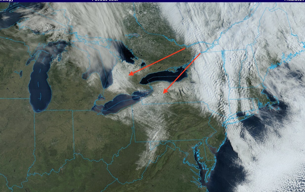
Finally some fresh snow cover in some places.
-
Winds howled here all night. Just ripping at times. Must have been some heavier snow squalls overnight as well. Patches of snow scattered around and on sheltered rooftops.
-
Numerous snow showers here this afternoon and one legit moderate snow squall. Temperature dropped to 34 with that. Moderate snow was coming down horizontal with very gusty winds. All melted on contact.
-
1
-
-
2.08" rain here last 24 hours. Temperatures most of that time were in the upper 30's.
Another wet month in progress. Thankfully a dry and warm week coming up.
-
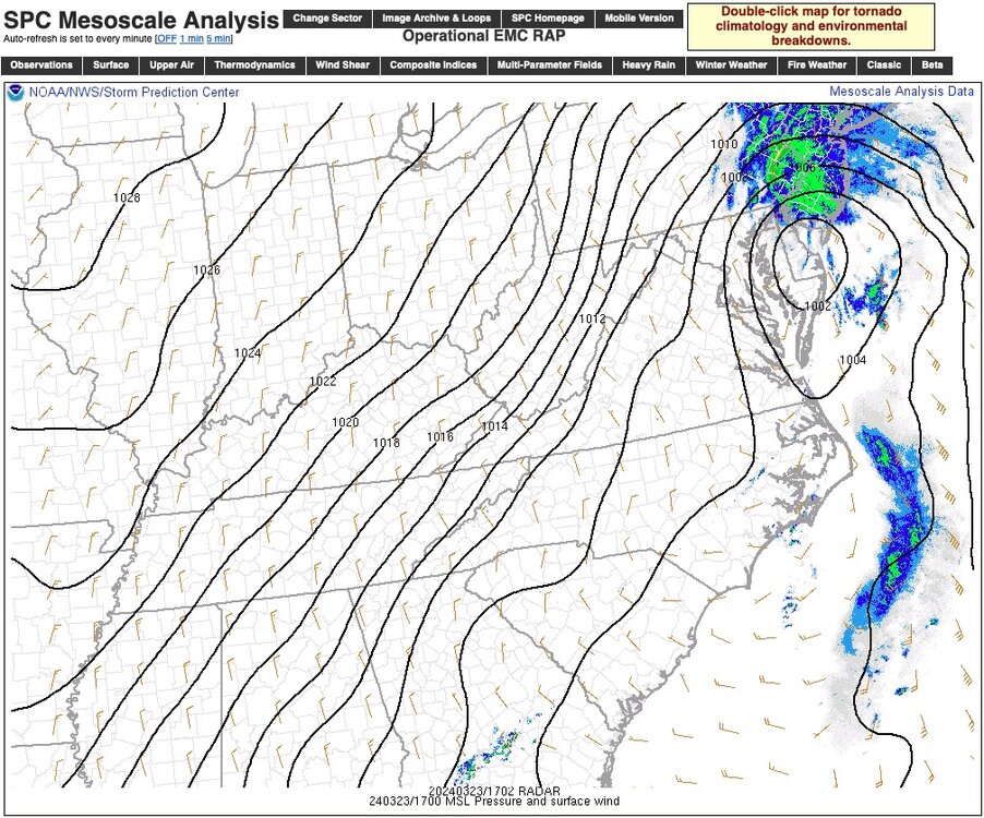
Flood Watch posted for parts of Mt. Holly CWA.
They are going with 1-2" rainfall.
Thankfully a drier pattern once beyond this. At least for a while.
-
1
-
-
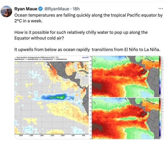
Thought this was interesting. La Nina seems to be coming on rather quickly as the Nino collapses. Will be interesting to watch this over the next weeks and months. That is some rapid cooling over a very short period of time. Latest EURO suggesting quite a busy Atlantic hurricane season.
Possible naming frenzy but impacts to be be determined.
-
1.11" rainfall last 24 hours and 1.61" last 3 days.
-
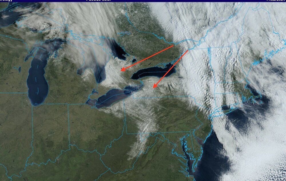
Pretty impressive satellite picture this morning.
https://www.meteo.psu.edu/ewall/PSUGOES_PA2/loop30v.html
Raining heavily here attm.
-
1
-
-
15 minutes ago, bluewave said:
Looks like a warm and wet pattern going into March as this is another example of these south based blocks linking up with the Southeast ridge.
March 4-11


My focus now turns to actually wanting warmer weather and avoiding Spring and Summer Drought. Winter is over and I'm ready to move on.
-
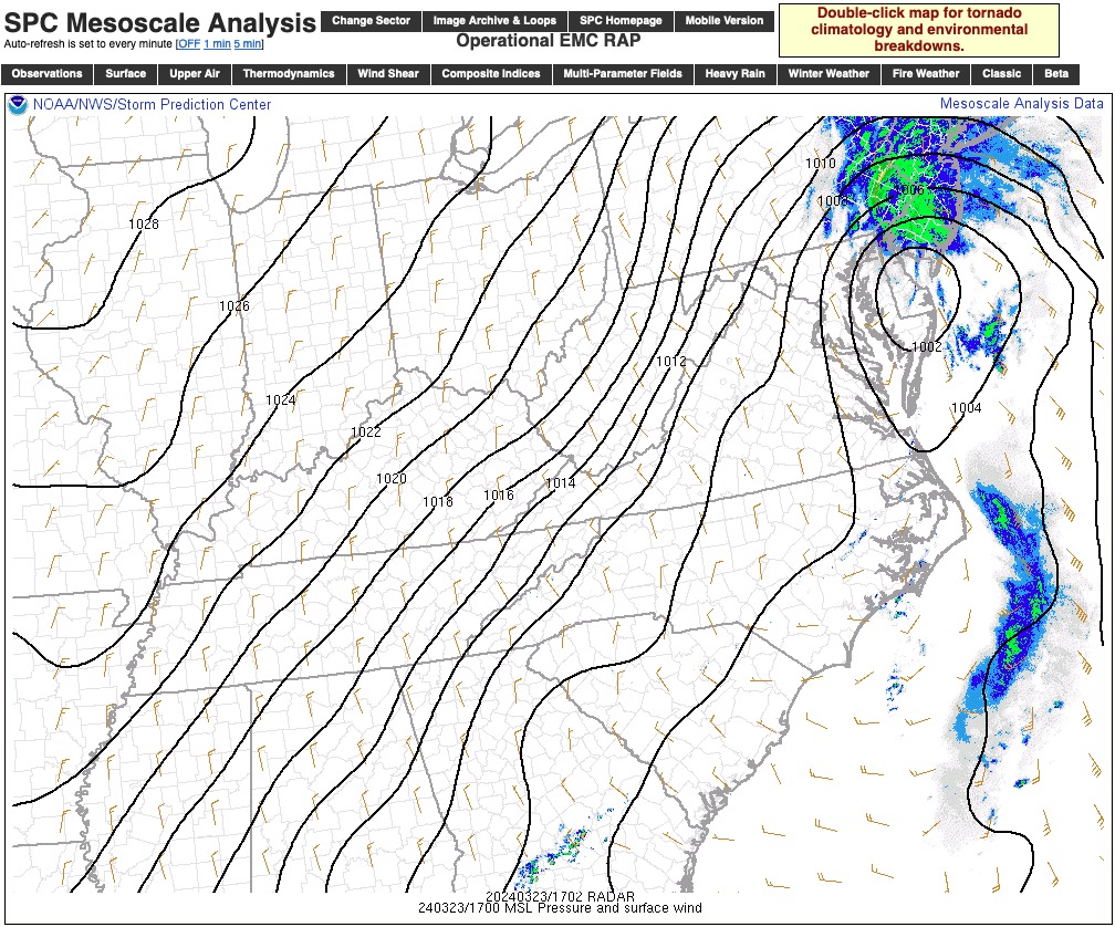
The howling winds from the overnight have died down but it is still kind of gusty out there.
Event rainfall total = 1.05" (.68" and .37").
Total Precipitation for February = 2.45".
Y.T.D. = 10.67".
Snowfall February = 11.5".
Snowfall for Season to date = 22.2".
-
2
-
-
1 hour ago, donsutherland1 said:
Winter 2023-2024 ranks 6th through February 28th:
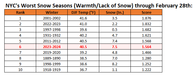
Thanks Don. My guess would have been #4 or 5. Real close to tying at least for #5.
-
2
-
-
7 minutes ago, donsutherland1 said:
Should NYC fail to see any additional measurable snow through March 10th, which appears likely right now, the odds would be tilted decidedly in favor of an unprecedented second consecutive season with less than 10" of snow. Winter 2023-24 will finish with a mean temperature of 40.5°. Of the 9 winters with a mean temperature of 39° or above, 7 (78%) saw less than 2.5" of snow from March 11 to the end of snow season (mean snowfall: 1.5"). Of the 13 winters with a mean temperature of 38° or above , 9 (64%) saw less than 2.5" of snow from March 11 to the end of snow season (mean snowfall: 2.4"). The subset of very warm winters (38° or above) that lacked snowfall through March 10 (less than 10") had mean snowfall of just 0.9" from March 11 to the end of snow season. Five of those six winters (83%) had less than 2.5". The lone exception was 1997-1998. The sample sizes are small highlighting the historic rarity of the kind of winter the region is experiencing.
Hi Don,
What does the latest "Winter Futility Chart" look like with just 1.5 days to go before meteorological winter is finished?
-
1
-
-
Rainfall last 24 hours .66".
Snow gone except for plowed mounds.
-
3 minutes ago, bluewave said:
The HRRR has some 70° potential today down around Philly.

With the way the warmth over performs I'll take the over on those temps.


March 2024
in New York City Metro
Posted
Event total here = 2.89".
Some rainfall and snowfall maps. Two day event totals. Click graphic to enlarge.