
MANDA
-
Posts
1,294 -
Joined
-
Last visited
Content Type
Profiles
Blogs
Forums
American Weather
Media Demo
Store
Gallery
Posts posted by MANDA
-
-
As of 7am:
Liquid total for the event = 2.25".
Snow total for the event = 26.5"
Ratio works out to be = Just shy of 12:1 on average.
-
As of 7am:
Liquid total for the event = 2.25".
Snow total for the event = 26.5"
Ratio works out to be = Just shy of 12:1 on average.
-
3 minutes ago, wdrag said:
Wantage NJ (this part): 940AM report 27" will get you an SD by 1130A. S- continues to accumulate. 30F. 10A/2
This is steady snow... not snow showers. The continued accumulation only increases roof and branch snow load.
Persistent band moving SSW through most of Sussex into Warren County. Based on radar looks like western Warren could be getting moderate snow at this time.
Have not picked up anything additional here since 7am obs so total remains at 26.5".
Sweeping drifts to 40". Impossible to walk through.
-
 2
2
-
 1
1
-
-
This Central Park stuff is such nonsense. Simple task and it can't be performed correctly?????
What a joke.
-
7:00 MT. ARLINGTON
Storm total snowfall is 23".
Drifts near 4' pretty much all around the house now.
Can't even make it from garage out to backyard anymore.
Just too deep to walk.
Snow depth is now 21" as difficult to measure with drifting and some compaction going on.
Picked up 1.5" last 2 hours. That is certain as driveway was plowed right after measurement 2 hours ago and
now has 1.5" new snow.
Still moderate snow under persistent band.
-
5:15 MT. ARLINGTON NJ
Moderate snow ongoing - on average 1" per hour.
Storm total and snow depth 21.5".
Picked up 2.5" during last 2 hours.
Temp 25.
Drifting in open area nearing 36" in spots. Deep enough that walking was near impossible.
Persistent band seems to be setting up in my area with echos moving NE to SW overhead.
-
Mt. Arlington at 3:00
19" for increase of 1.5" over last 2 hours.
While rate of fall has lessened last 2 hours still mainly moderate snow ongoing at this hour.
Now it comes down to how banding evolves next 4-8 hours and into the overnight.
Temp 22.5
Drifting 24-28"
-
1:00 from Mt. Arlington
17.5" storm total and current depth
Up 3" in 2 hours.
Temp 22
Drifting to 24" on exposed NE side of house.
-
11am from Mt. Arlington NJ.
Storm total and depth 14.5".
That is up 4" from the 10.5" measurement at 8am.
Just steady and persistent moderate to sometimes heavier snow last 3 hours.
Temperature 22.3
Banding just starting to develop south and east of here vicinity NYC/NE NJ.
-
2
-
-
Mt. Arlington NJ.
Moderate snow at 8am obs time.
Temperature 20.7.
Storm total and snow depth so far 10.5".
Near blizzard conditions at times.
-
1
-
-
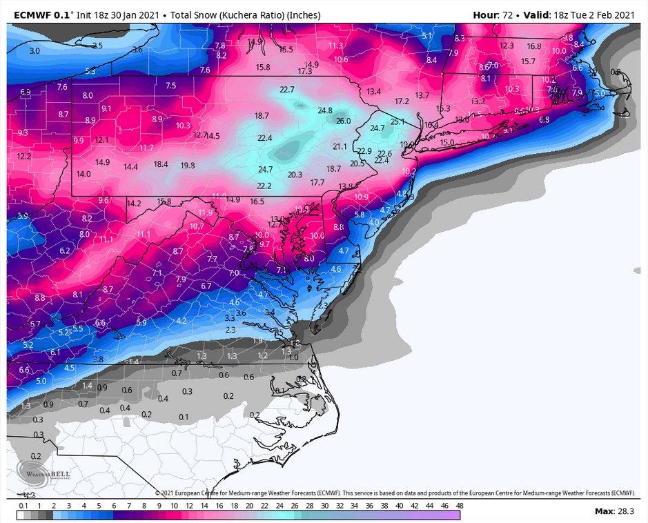
Putting aside the snow maps for a moment. All guidance has been consistent last 3-4 runs at least with very robust QPF.
Even allowing for it being a bit overdone where max qpf can sync up with best ratios and remain all snow that alone suggests some
spots see in excess of 20". Final "jackpot totals" will depend on where banding sits and pivots. Keep in mind...what goes up must come down
so you want to be in the band because the subsidence on either side will keep your totals lower.
Some favored spot can see 24-30" and I would not be surprised. Best chance I think is north of 78 and west of 287.
-
2
-
1
-
-
-
-
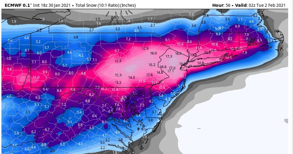
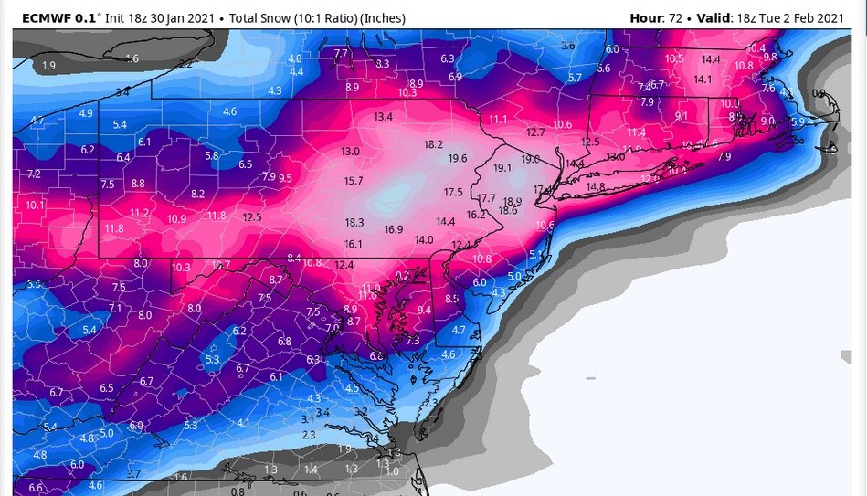
18Z Euro is locked and loaded !
Snow map through 02Z Tuesday
-
1
-
2
-
-
Hi Walt-
So happy to have you on these forums. Big follower of you from your KBOX and KPHI days.
Great input and insight. Always appreciated.
-
5
-
1
-
-
17 minutes ago, sussexcountyobs said:
Approaching .8" here in Vernon @ elevation of 1217' with very light snow falling . Temp 27.5
Thanks for the report from Sussex County high ground. Might not see many obs of 1"+ from this event.
Really thought some 2-3" amounts would of shown up around your area of Sussex.
-
Just took measurement. Total 1". Everything covered including roads in my little traveled neighborhood.
Temperature currently 26 with some light freezing drizzle.
Event performed pretty much as expected along and north of I78. I was expecting some 2" to even a bit more over the higher terrain of
Sussex but waiting to see some reports - nothing that I've seen so far of 1"+.
-
12:50 - burst of moderate snow ongoing. Had a brief bust mid morning as well.
1/2" on the ground. Sticking to everything. Current temp 27.1. Been holding
between 26 and 27 since early morning. Based on radar will becoming to an end
at least for a while in the next 30 min.
-
Had .95" last 24 hours. Looks like back to our regularly scheduled program for this week with not much going on
next 5-7 days. Still hopeful last week of month can deliver at least some snow and perhaps a notable cold shot.
Chances of significant snow event (>6") not looking likely at this point.
-
NWS PHI mentions significant icing possible along and north of Rt 78 in afternoon AFD.
If trends on EURO persist this could be real possibility.
Worth watching out for.
-
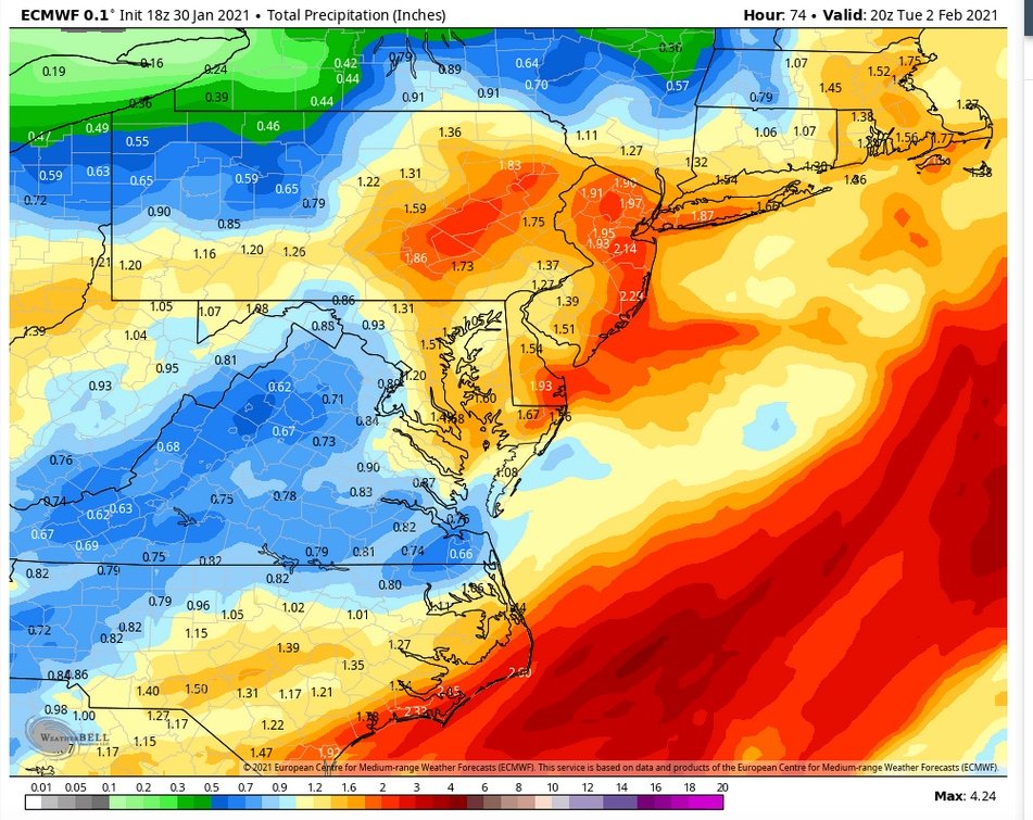
Although likely overdone EURO shows significant amount of freezing rain over NNJ, especially inland. Did pretty well with ZR on last event, although a bit overdone.
Surface temps solidly below freezing for long duration so threat of significant icing, up to 1/2" is possibility. Lets hope is more IP than ZR. Half inch ice accretion is significant
and can bring down tree limbs and power lines.
Euro currently showing 1/4 - 1/2 amounts NNJ with some locally higher amounts Sussex County. Thinking the 1"+ QPF is likely also overdone so would expect ZR totals to be near lower end
of EURO range.
This post in reference to Monday late afternoon into Tuesday event. The Sunday night into early Monday event looks insignificant for metro NYC.
-
Think the main thing to take away from EPS this afternoon is that there is the threat of storm along the east coast in about a week.
Even stronger signal for another bitter cold arctic outbreak by Sunday into last week of January and perhaps into first week February.
Much higher confidence in that than any storm details at this point...overall pattern on latest eps can deliver the goods as far as extreme
cold in concerned.
-
2
-
-
14 minutes ago, PB COLTS NECK NJ said:
The skill is not in the snow maps.
Trust me I know that. But I was just trying to put it in simple terms for others. If your comment above applies to snow maps then it would certainly apply to your original post about individual members being "very deep". The individual members and individual members snow totals are directly related.
Looking at the 500 EPS mean also supports the lack of snow on the individual member maps. First vort is allowed to escape east (no phasing) while deeper arctic s/w dives into and through the mid-west.
All of this is not really worth discussing since as I said the op and the eps will change many times between now and next Tuesday my only point was that looking at this one single run of the eps it was not very encouraging. Can almost guarantee the 00Z op / eps will have a different solution since we are 7-8 days away.
-
1
-
 1
1
-
-
7 minutes ago, PB COLTS NECK NJ said:
The EPS looks good , it`s cold with some very deep members
The EPS members don't look that encouraging to me as of now. Granted they can and will change in the days ahead but 12z 01/21 EPS show 6 out of 51 members giving CP 6"+ (3 of the six give 8-12" and the other 3 are right around 6) and the majority of the other 45 + the control give CP between a coating and 3" over the next 10 days (thru 12Z 1/31) that is not encouraging signal as of right now.
Like I said things are likely to change several times over the next week but taking this run of the EPS at face value not much to write home about.
-
1
-
Obs and nowcast Major Nor'easter near blizzard Sunday afternoon Jan 31 - Sunrise Wednesday Feb 3
in New York City Metro
Posted
Walt-
Noticed the same "blue tinge" here as well. Any idea what causes that? I've noticed it in other deep snows of the past?