
MANDA
-
Posts
1,286 -
Joined
-
Last visited
Content Type
Profiles
Blogs
Forums
American Weather
Media Demo
Store
Gallery
Posts posted by MANDA
-
-
6 minutes ago, wizard021 said:
I did think it would.
A win for you AND the NAM !
-
Back to moderate snow here.
Based on radar meaningful echos will be past this area in next 30 min or so.
We'll see if can get anything additional this evening / overnight.
Not expecting much.
-
Pure sleet here in Mt. Arlington now.
Temp 21.5 degrees.
New snow 3.6" right at time of changeover.
Didn't think sleet would get this far NW.
Just surged NW in a hurry. Win for the 3K NAM.
-
 1
1
-
-
Final Mt. Arlington, NJ
1.2" - melted .10".
-
 1
1
-
-
22 minutes ago, mikem81 said:
Ill take this look from the GEFS for now

Absolutely agree. I'll take this for now. All options open at this point but have to like cold high banked to west and north.
Opens the door to freezing / frozen precipitation especially inland.
Thursday / Friday event looks like a "no go" for this forum but I will take this for now and see where it heads.
-
Breaks of sun now.
Looks beautiful !
-
1
-
-
Breaks of sun now.
Looks beautiful !
-
1
-
-
Final total here in Mt. Arlington is 4.1".
Picked up .9" over last 2 hours.
Just some S--/flurries wrapping up as of 3:45.
Nice event to "freshen up the pack".
-
1
-
-
1:00 Mt. Arlington, NJ
Total 3.2" with 1.2" last 2 hours.
Light snow now and per radar back edge is heading this way.
Maybe another 60 - 90 min tops before we are done here.
Temp 26.4.
Looks nice - snow sticking to everything.
Easy to measure.
-
1
-
-
11:00 a.m. Mt. Arlington, NJ
New snow since SB 8:00 = 2" over 3 hours.
Temperature 26.6.
Moderate snow ongoing.
Based on radar my area of NW NJ is on NW fringe of the "good stuff".
Better rates and totals coning in southeast of here.
Thinking approx 4" for an event total here.
We shall see.
-
9:40 Mt. Arlington
Solid moderate snow.
26 degrees
Snow began @ 7:50
Just ESTIMATE, have not been out yet but 1/2" looks like it has fallen over last 90 min or so.
-
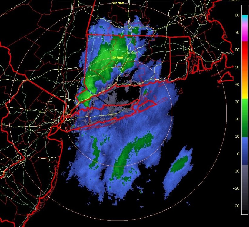
Unreal. Just when it looked like OKX radar was about to be clear a large area of 20 - 30 dBZ returns blossomed over
western 1/3 of Ct. Large area of steady light snow! Maybe a patch of moderate embedded? System just will not give up the ghost.
-
1
-
-
Based on latest KDIX / KOKX radar the last of the precipitation / bands will have exited all land areas of the and be out over the ocean over the next 60-90 mins.
After (I'm estimating about 84 hours) there will be no precipitation falling over the OKX / PHI CWA.
Pretty amazing.
-
1
-
-

This from latest 2/3 - 4:26 P.M. PHI PNS Statement.
Have no idea why it was changed from "trained Spotter to "broadcast media"
Also amount dropped from 35.5 to 35.1 not sure why that is either.
From what I've read will take weeks to months to confirm if this amount will overtake the current 34" NJ state record.
Office of NJ State Climatologist will conduct detailed investigation.
-
1
-
-
Had period of light snow here about 30 min ago as well. Just flurries now.
Just trace amounts added to 27" storm total.
-
1
-
-
33 minutes ago, wdrag said:
I didn't google but am sure it's related to water content and light passing through.
Thanks!
-
1
-
-
1 minute ago, wdrag said:
Catching up now: CoCoRAHS snow amounts etc. Meanwhile...interesting here in Wantage NJ. My snowfall through 930A was 27", but my SD ~18... and looks blue in the footsteps. Plenty of water content. At least 2-3" via attached.
NOHRSC analyzed snowfall, CocoRAHS water equiv and CoCoRAHS snowfall follow.


Walt-
Noticed the same "blue tinge" here as well. Any idea what causes that? I've noticed it in other deep snows of the past?
-
As of 7am:
Liquid total for the event = 2.25".
Snow total for the event = 26.5"
Ratio works out to be = Just shy of 12:1 on average.
-
As of 7am:
Liquid total for the event = 2.25".
Snow total for the event = 26.5"
Ratio works out to be = Just shy of 12:1 on average.
-
3 minutes ago, wdrag said:
Wantage NJ (this part): 940AM report 27" will get you an SD by 1130A. S- continues to accumulate. 30F. 10A/2
This is steady snow... not snow showers. The continued accumulation only increases roof and branch snow load.
Persistent band moving SSW through most of Sussex into Warren County. Based on radar looks like western Warren could be getting moderate snow at this time.
Have not picked up anything additional here since 7am obs so total remains at 26.5".
Sweeping drifts to 40". Impossible to walk through.
-
2
-
1
-
-
This Central Park stuff is such nonsense. Simple task and it can't be performed correctly?????
What a joke.
-
7:00 MT. ARLINGTON
Storm total snowfall is 23".
Drifts near 4' pretty much all around the house now.
Can't even make it from garage out to backyard anymore.
Just too deep to walk.
Snow depth is now 21" as difficult to measure with drifting and some compaction going on.
Picked up 1.5" last 2 hours. That is certain as driveway was plowed right after measurement 2 hours ago and
now has 1.5" new snow.
Still moderate snow under persistent band.
-
5:15 MT. ARLINGTON NJ
Moderate snow ongoing - on average 1" per hour.
Storm total and snow depth 21.5".
Picked up 2.5" during last 2 hours.
Temp 25.
Drifting in open area nearing 36" in spots. Deep enough that walking was near impossible.
Persistent band seems to be setting up in my area with echos moving NE to SW overhead.
-
Mt. Arlington at 3:00
19" for increase of 1.5" over last 2 hours.
While rate of fall has lessened last 2 hours still mainly moderate snow ongoing at this hour.
Now it comes down to how banding evolves next 4-8 hours and into the overnight.
Temp 22.5
Drifting 24-28"


January 28-30th Possible Nor'easter
in New York City Metro
Posted
And at 90 it leaves very little behind in the southern stream. Extrapolated out I believe it would have been an interesting 102 and beyond. Still, LOTS of moving parts and best we can do is watch the trends. NOTHING is written is stone and likely won't be for a while.