
MANDA
-
Posts
1,294 -
Joined
-
Last visited
Content Type
Profiles
Blogs
Forums
American Weather
Media Demo
Store
Gallery
Posts posted by MANDA
-
-
For those still looking for cold air on our side of the pole currently Yellowknife is sitting at -40F and -47 at Fort Good Hope.
The cold is coming to the western and central U.S. and down to the gulf coast in a big way. Direct and fast discharge S.S.E. It will eventually seep / ooze east but the western and central states from Canada to the Gulf of Mexico are going into the deep freeze with record breaking cold. Hope the power grids are ready. Especially the wind turbines in Texas. They didn't do so well last time this happened. Temperature departures of -50 to -70 looking more likely over the Northern Rockies and Northern Plains. Bitter cold day for Iowa Caucus. Below zero!
-
 3
3
-
 1
1
-
-
Snow pack in my area. Currently 4.5" - 5" of snow pack remains at my house.
Can't speak for areas to my north and west but the snow pack here is heavily crusted over. It almost supports my weight (160#) when I walk over it, I only make minor indentations. My point being I'm not sure how much rainfall it will absorb at least initially. Going to be a good deal of runoff as the heavy rains get underway. Again, not sure what the condition of the 6-12" snow pack is to my NW. Just thought it was worth a mention.
-
3
-
-
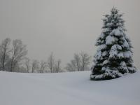
Always like a visible satellite pic day after a snowstorm.

-
8
-
-
Final storm stats:
Two day snowfall = 7"
Two day melted = 1.22"
-
3
-
-
Final (more or less as light snow still ongoing off and on) Snowfall = 6". Depth at 8am = 5.5".
Will update melted total shortly.
Went to rain at 8:15 last evening with 3.8". Went back to snow and at 3am was 6". Settled and compacted to 5.5" at 8am obs. time.
Very heavy and wet snow pack.
-
2
-
-
Moderate rain here, mixed with some sleet. Change over about 8:15. Measured 3.80” at 8:15 when I heard sleet mixing in. Currently all rain and 32 degrees. We’ll see if I can pickup a bit more snow tomorrow morning. Not expecting much though.
-
1
-
-
Light to moderate snow ongoing. 29 degrees.
2.5" as of 6pm measurement. Guess is another 1" since that time.
Will measure again at 9pm.
My forecast of 4-6" for MBY seems on track.
-
1
-
-
Just now, EastonSN+ said:
It's raining there now?
Looks like snow is falling in the lights but melting on the pavement.
-
1
-
-
-
Per friend in Pittstown, Hunterdon County the sleet has gone back to snow.
-
1
-
-
Just measured. 2.5” and 27.6 degrees.


-
7
-
-
Pittstown, NJ now pure sleet (light) per friend.
Mix line has made little to no progress over the last hour. Suspect still snow north of Pittstown over Central and Northern Hunterdon.
-
1
-
-
Per friend in Pittstown, NJ Hunterdon County. Snow/sleet mix as of 15 min ago.
1" on the ground.
Currently light to occasional moderate snow here. 27.7 degrees.
It looks just shy of an inch. Will measure at 6pm.
-
28 degrees. Light to sometimes moderate snow. Not quite 1/2” yet.
-
1
-
-
6 minutes ago, lee59 said:
Columbus Circle webcam for anyone interested:
https://www.earthcam.com/usa/newyork/columbuscircle/?cam=columbus_circle
Going to come right out and say it....CP is not getting an inch.
-
Model support growing for major Arctic dump of cold air into the western 1/3 of the U.S. and then oozing east. Tremendous surface high pressure (1050-1055 mb) forecast to build over northern and western Canada to aid and abet the Arctic plunge. Temperature departures could reach 50-60 below normal over parts of MT/WY.
Worth watching as it looks like a dynamic pattern is setting up. We'll see if any southern branch s/w can phase with northern branch s/w to really make things interesting. Southern branch looks to stay active and juiced so MAYBE things will work out for something really noteworthy next 10-14 days.
-
2
-
 1
1
-
-
Latest WPC 7 day QPF. Pockets of 5" locally.

-
Bright banding (sleet / big wet flakes) showing up on radar southwest and west of PHL.
-
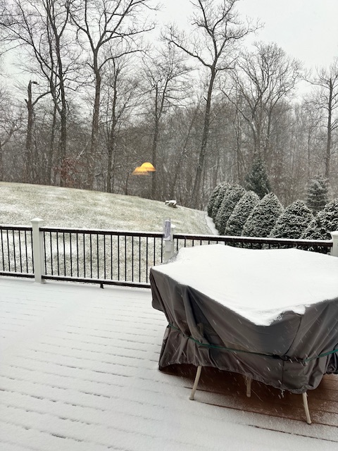
S-- here. Coating the deck.
-
13 minutes ago, mikeysed said:
Left Southern Morris County. Currently at Crystal Springs Resort. Expecting 12" on the mountain. Room is at ~1300 elevation, mid mountain. Flurries and 27 degrees. Plus my 12" ruler
Don't think you are getting 12" but send pictures anyway
-
2 minutes ago, HVSnowLover said:
The 2 inch line looks like it goes into the NW corner of the Bronx. There does seem to be a tight NW to SE gradient for sure.
Looks good to me. Have been expecting pretty much this all week....including going over to a mix for a time at my location. We'll know for sure in 24 hours.
-
1
-
-
2 minutes ago, Northof78 said:
Which thread are we using for obs? This one or the one just created?
-
Holding with my 4-6" forecast for my location and still believe will go to mix and perhaps just plain rain at 33/34 degrees overnight / early morning. I am thinking 4" will be closer to actual than the 6" but staying with that range.
-
1
-
-
22 minutes ago, DenvilleCyclone said:
In Denville, NJ, Morris County, I’m right on the 4-8,3-6 line for sure. Once you head east down the hill route 80 towards Parsippany there will be a sharper cutoff. Smell the rain for good snow.
")
Heading westbound on 80 I've seen some very sharp increases in snow depth and deteriorating road conditions once to exit 35 as you start to gain elevation. Works in reverse if you are heading eastbound.
-
3
-

Two Mdt to high impact events NYC subforum; wknd Jan 6-7 Incl OBS, and mid week Jan 9-10 (incl OBS). Total water equiv by 00z/11 general 2", possibly 6" includes snow-ice mainly interior. RVR flood potential increases Jan 10 and beyond. Damaging wind.
in New York City Metro
Posted
Very concerning for those in NNJ who are affected by river flooding. Street and highway (urban flooding) is one thing but when a river overflows into your house that is something else. Feel bad for those affected. Stress level must be through the roof. Me personally if I went through it once I'd be out of there.