

MANDA
-
Posts
1,309 -
Joined
-
Last visited
Content Type
Profiles
Blogs
Forums
American Weather
Media Demo
Store
Gallery
Posts posted by MANDA
-
-
Some maps with total rainfall since last Wednesday. (click map to enlarge)


-
 4
4
-
-
Still running on the lower side of totals here since last Wednesday when this wet pattern began.
Last 24 hours = .53" and total since last Wednesday = 1.16".
-
20 minutes ago, SnoSki14 said:
Not really seeing that big autumnal front just yet.
Probably won't happen til October. Nino Octobers are typically cooler than usual
At this point I'll take a front that will at least clear out the humidity! Getting a little tired of the warmth + humidity.
-
Nickle and dime totals last several days here.
Totals ending 8:00 a.m.:
Friday = .32"
Saturday = .14"
Sunday = .17"
Since 8am this morning .12"
Heavier totals pretty much all around my location.
-
Several rounds of showers and T-showers last evening and overnight. Fast moving and the bulk of the rain was to my NW.
Received .32" here.
-
Early first look at 00Z tropical models. Still bending more westward near end of run. The end of the run starts to enter the pivotal time as Lee approaches 70W. Exactly where it is located at 120 hours and the direction and speed of movement at that time will start to tell the tale of where it is ultimately headed.
-
1
-
-
12Z EPS has nudged left with some members land falling Lee along parts of the Northeast coast. Going to be very interesting to follow EPS next several days for longer range trends, especially after data from synoptic missions gets into the models. Impacts **IF ANY** are 7-9 days away. Will be interesting to follow....not an absolute slam dunk Lee is OTS. Has been my feeling and remains so.
-
Just now, Amped said:
The eye has improved a lot in the last hour, kind of reminds me of Dorian undergoing RI. They could probably skip cat 3 on the next advisory and go straight to 4.
I think they will.
-
9 minutes ago, StantonParkHoya said:
It passes through Franklin's upwelling as well
Potentially yes, but not until mid next week or so.
-
7 minutes ago, NJwx85 said:
Obviously, but that's not the reason for weakening in the next 5 days. The model is attempting to show the result of at least one ERC which massively expands the wind field. In fact the HAFS shows a new period of intensification beginning as the run ends.
ERC...

New eye emerging:

ERC complete:

Totally understood, was just trying to convey I was not expecting it to stay at cat 4 / 5 levels for an extended period of time and certainly not to once north of the islands. Would even be surprised if after the ERC is complete if it got back to near peak or peak.
-
1 minute ago, NJwx85 said:
12z HAFS-A. If true, Lee will probably peak in intensity on Saturday or Sunday.
Check out how much the wind field increases from now until the end of the run.


It has to weaken, you are not going to keep this pristine environment that long. Will be a huge wave and swell producer for east coast and Atlantic Canada but this is not going to hang onto cat 4 / 5 status once north of the Islands. The environment and overall pattern does degrade.
-
Nice dual outflow channels with northern one evacuating into an atmospheric sink.

-
3
-
-
5 minutes ago, NeffsvilleWx said:
Recon is back on the ground per ADSB data. Wonder what happened.
They looked at the latest satellite and said "hell no"

-
1
-
 10
10
-
-
Wet times ahead with potential moderate to severe flooding for western and NW sections of this forum into parts of New England. Good thing it has been on the drier side lately. This is without anything from Lee. Still seems more likely than not that there is no effect from Lee as far as wind and rain for the east coast but that is not a lock IMO.
-
4 minutes ago, SchaumburgStormer said:
Going straight Hulk mode today.

Just amazing! Wish recon could of been in there from earlier this morning. Would have loved to see actual pressure and wind data. I think though that it is just coming into travel range....about 50W is when they usually begin recon.
-
40 minutes ago, Windspeed said:
Oh...

Lee is on his way to something special!
-
 1
1
-
-
1 minute ago, drstuess said:
Structure got a lot better

Sent from my SM-S901U using Tapatalk
Super impressive core organization.
-
2 minutes ago, Allsnow said:
Either way you slice it, this is the hottest week of the summer and it does feel like July
Agreed! Thankfully the September sun angle helps a little, would have felt worse with a July sun angle. Impressive though.
-
1
-
-
7 minutes ago, Windspeed said:
Lee is ahead of my forecast; and I thought I might've been too hasty. Think it will be a major by 5PM AST now. The eye is warming fast. Two CBs rotating around should drop pressures like a rock. Recon will find a hurricane undergoing rapid intensification when it reaches the core this evening.

Classic RI satellite signature !
-
3
-
-
13 minutes ago, Eskimo Joe said:
Will be interesting to see over the next 2-3 (12Z / 00Z) model cycles if the synoptic mission data causes any notable shift in track forecast.
If Lee travels near or over the impressive cold wake left by Franklin it will be well off peak before it would affect Bermuda. If it stays south and west of that it would hold onto major status longer. Regardless, it will be generating huge waves and swells next week that will be an issue for the U.S. east coast, Bermuda and Atlantic Canada down the road. Not to mention the Islands in the coming days.
-
4 minutes ago, Rtd208 said:
Fascinating stuff to follow.
-
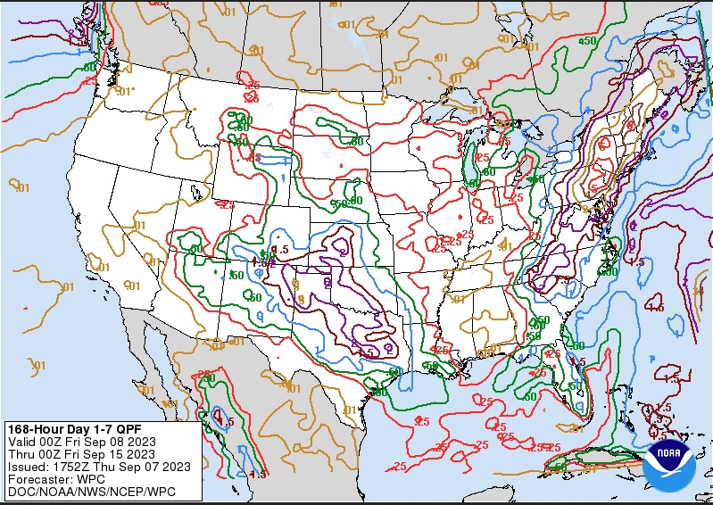
Latest 7 day QPF from WPC. Reference post from Walt early this morning. Looks like a wet time for the NW and western sections of this sub forum over the next 7 days. Pretty much the same places that have been drenched the most all summer long. We better hope Lee stays out of the picture because any excessive rainfall from a tropical system (especially over these western and NW sections and New England) would not be a good situation. Very likely Lee does stay away but not guaranteed at this point. Regardless, some wet weather for parts of this sub forum over the next week to 10 days.
-
1
-
-
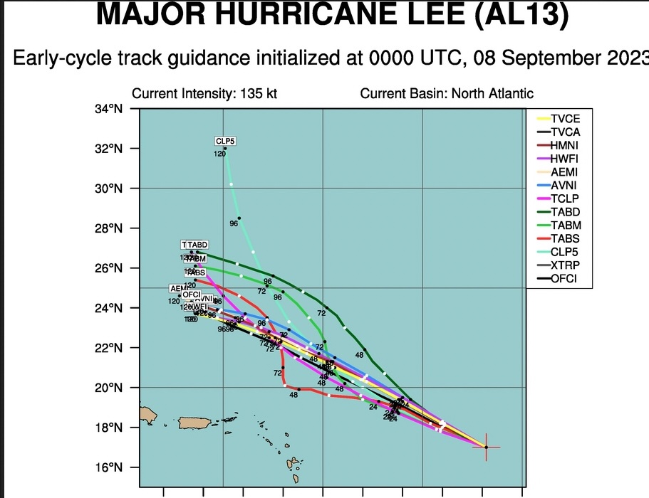
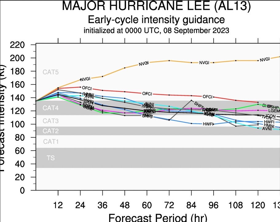
Long ways to go but here are latest EPS (Tropical Models) and Intensity Guidance.
EPS does show a cluster staying more south and coming further west. More so than prior cycle.


-
1
-
-
Had a low here of 47 this morning. Along with a light breeze it was legit light jacket for a time earlier this morning.
Walpack dipped to 42.
-
2
-


Category Five Hurricane Lee
in Tropical Headquarters
Posted
That track would cause moderate to severe beach erosion, tidal flooding and extremely dangerous surf/waves into the Gulf of Maine and on the North and NE facing beaches of Cape Cod ( Boston Harbor as well) as N to NE winds would pound the coast until the center passes a given latitude and winds back into the NW. If it were to track more on the left side of the cone it of course would be worse but that is not likely at this time. Sprawling wind field will have plenty fetch to pile up water in advance of the center before it passes. Expect coastal flood warnings etc. as we move into late week.