
MANDA
-
Posts
1,309 -
Joined
-
Last visited
Content Type
Profiles
Blogs
Forums
American Weather
Media Demo
Store
Gallery
Posts posted by MANDA
-
-
7 minutes ago, forkyfork said:
the pattern was perfect for a nyc ku
Exactly! It was just the details that took a bit to fine tune but those maps were classic "big event" look.
-
57 minutes ago, jbenedet said:
GEFS is south.
Bigger point is the way the surface high becomes one extended all the way to Bermuda. That’s a “too warm” problem for all densely populated locations along the coast. West is best.
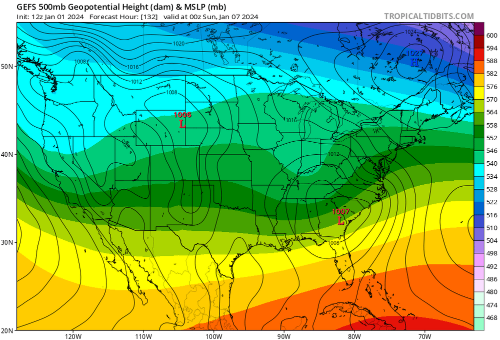
Nice to have a high to the "north" but that is far from a classic "look" for snow in the big cities. Personally I like the "banana" look with center over the northern lakes. That high position with marginal cold air to begin with ain't gonna cut it along and southeast of I95. Even interior could have issues with mix depending on exact track. I'm not sold on an all snow solution for any part of this sub forum to be honest. I'm more concerned for further north coast hugger than suppression.
-
It is a week away. The details are far from certain and the models WILL waffle back and forth.
I'm just happy there is some potential and something to track. Looks like legit chance of measurable snow especially interior.
For now just watch the model trends....long way to go.
-
 2
2
-
-
2 minutes ago, Wxoutlooksblog said:
No major change in sight.
WX/PT

Ugly, just ugly.
-
1
-
-
Not much mention about the state of the Great Lakes water temps and ice cover. Just checked. On average GL water temps are running about 12 degrees F warmer than this date last year. Average ice coverage is .20%. Neither of those two things is going to help us chill down in any notable way over the next 2 weeks at least. Any "cold" air mass crossing those waters is going to modify significantly.
If we could get a frigid air mass to surge southeastward over those warm waters the LE snow guns would roar but not seeing that happen anytime soon.
-
1
-
 1
1
-
-
7 minutes ago, LibertyBell said:
thanks, so regularly replace the filter?
Yes, keep filter clean, vents on device clean and dump and clean the catch container daily.
-
1
-
-
Two day rainfall = 2.48".
December = 10.43".
2023 = 63.76"
-
1
-
-
Just now, LibertyBell said:
Yess and when the steam heat turns on everything gets worse!
How strong or big of a dehumidifier do you need?
I'd be careful running a dehumidifier. If not kept clean you can pump all sorts of bacteria and mold into the air on top of what you may already have. You've got to keep them clean.
-
Two day rainfall = 2.48".
December = 10.43".
2023 = 63.76"
-
11 minutes ago, Evie3 said:
Grew up on a dairy farm in Sussex county, near the former Monastery off of 202. There was no 287 or 78, of course. We sold our milk to the Ideal Dairy, which I think is still in business. I recall watching Green Acres as a kid and thinking it was about my parents LOL. As a young child I recall a time in the early 1960s when Kennedy Airport (then Idlewild) was closed because of a bad snowstorm. We had a 1 mile+ long driveway off of 202 and were snowed in for a long time - well over a week. Thankfully we had a generator, fuel tanks and firewood but by the time someone came to plow us out we were running low on canned goods. After that my mother (who grew up in Newark and was used to being able to walk around the corner to the store) started hoarding canned goods. Even though we moved to the suburbs when I was 8 the canned goods thing continued, I don't think she ever really got over it....People find it hard to imagine that was New Jersey, but it was. Who knows, it could happen again! These things tend to be cyclical over long periods of time.
A simpler place and time. Something to be said for that.
-
2
-
-
1 hour ago, forkyfork said:
way out there but this pac isn't going to cut it

Nope, it sure ain't if it verifies.
-
2
-
-
Not expecting any snow here for the rest of December. That being the case I will be behind the curve of last December when 4" of snow fell here.
My expectations on this December were very low but I didn't think it would suck quite this much. My expectations for January are also guarded to say the least, especially if the opening half of the month craps the bed.
-
Two day event total = 4.44".
(3.82" and .62")
Trace snow this morning as well.
-
1
-
-
2 hours ago, Tatamy said:
Anyone else (NW NJ / NY)have a small coating of snow on the ground this morning? My low so far has been 33.5. I looked outside and thought this can’t be real.
I did. Trace amount of the deck. Two day rainfall total = 4.44" (3.82"+ .62")
-
3.82" here as of 8am. Winds nothing notable. Maybe some gusts to 20 mph. earlier this morning.
Ground is saturated.
-
1
-
-
3.82" here as of 8am. Winds nothing notable. Maybe a few gusts to 20 mph earlier this morning. The ground is saturated.
-
1
-
-
Getting off and on torrential downpours here. Would do a July or August day proud for intensity / rainfall rates.
The bursts of rain have been brief but just shows you the atmosphere is primed for heavy downpours.
Someone in NJ west of I-95 sees 6" in my opinion.
-
1
-
-
1 minute ago, bluewave said:
Yeah, the GFS doesn’t have much in the way of an inversion in the soundings so has gusts near 70 mph at the beaches.

Will be bad news if verifies. Saturated ground and SE winds of that intensity = not good. Tree and power line damage likely. Again, if it verifies. Models have been overzealous with wind forecasts with several events in the recent past.
-
3 minutes ago, cleetussnow said:
This looks like shit:

500 MB HTS in the low 560's is something most of us don't want on Christmas morning. The 546 at KINL not much better!
-
15 minutes ago, bluewave said:
This may be the warmest day 10-15 EPS signal I ever saw for Canada this time of year.

Not getting any U.S. cold shots between Christmas and New Year's if that is correct! It is a 360 hour prog but the trend is your friend in this pattern. **IF** this come close to reality it will take a while to scour out that Canadian warmth so the first 7-10 days of January **COULD** be shot.

-
2.46" rainfall here.
Snowfall .30". Everything was plastered and caked in a wet snow. Only concrete and blacktop remained wet.
To Walt's point elevation played big role. Drove down off the top of the ridge I live on (1060') and once to Rt. 80 exit 30, just a mile away very little snow and mainly wet. Bit of elevation near Rockaway on 80 and ground was whitened go down 100' or so and all gone.
-
Wind was non event here. Barely a light breeze at times over the last 24 hours.
Rainfall just glancing at the gauge (will take measurement at 8am) looks like 2 to 2.5".
Temperature down to 32 even with light to some moderate snow. Grass and deck coated already with at least 90 min worth of light to some moderate snowfall to come. COULD see 1" on coldest surfaces?
-
1
-
-
Based on latest radar trends this is not going to produce anything more than 1" for NW NJ. Best rains aimed up along and especially east of I95. Long Island looks to do best with heaviest totals as models have been generally suggesting.
-
2
-
-
After looking at all the overnight data I think it is safe to say we have started to

I am not at all surprised. The signal has been there for a lackluster December. Raging Pacific Jet just ain't gonna cut it for cold and decent snow in the east. Pattern needs to relax and reshuffle and that is not likely to happen before the end of the month.
December = shot.
-
4
-


Two Mdt to high impact events NYC subforum; wknd Jan 6-7 Incl OBS, and mid week Jan 9-10 (incl OBS). Total water equiv by 00z/11 general 2", possibly 6" includes snow-ice mainly interior. RVR flood potential increases Jan 10 and beyond. Damaging wind.
in New York City Metro
Posted
Better hope that trend does not persist. I abandoned suppression solutions yesterday. Still not convinced even interior does not have mixing issues before all is said and done. That 50/50 low is the only thing saving the day from a hugger or cutter. Surface high pressure nice to have but not ideal location by any means and not that cold of an air mass to work with. We'll see where this heads as guidance rolls in today, tonight and tomorrow. I'd keep enthusiasm in check for inland areas and as for the coast consider it a win if you can break the lack of 2" streak.