-
Posts
2,792 -
Joined
-
Last visited
Content Type
Profiles
Blogs
Forums
American Weather
Media Demo
Store
Gallery
Everything posted by MANDA
-
My blizzard snows (12.5") from a week ago are essentially gone, except for drifted areas and plowed mounds. I'm now back to working on what was left from the January glacier. That stuff is still a crusty, crunchy mess of snow and ice. Before the blizzard a week ago there was about 3" or so of that left and that is pretty much where I am at now, 3" with about 70% coverage.
-
Including what fell this morning (.10") I'm at 49.9" for the season.
-
-
Picked up .02" melted and .10" new snow this morning. Has melted already. Stuck to everything except the street which still has salt residue. Average snow depth this morning with about 70% coverage is 3". Most of that measured in north facing / shadier locations. Southern facing lawns and slopes bare ground to about 1".
-
EWR snowfall nearly double mine
-
February Precipitation stats at my location: Melted: 1.96". Y.T.D. Melted: 4.72". February snowfall: 15". Snowfall Season to date: 49.8". AVERAGE snow depth this morning with 90-95% coverage: 3.5". South facing lawns and slopes bare ground to 1.5". Shaded / north facing locations: 4-5". Was driving around southern Union and Morris Counties yesterday (Chatham, Summit and New Providence) and snow melt pretty dramatic there. They had 15-20" in spots and there is quite a bit of bare ground. Eyeballing looked like 3-4" in areas with most remaining depth. By this coming Monday, 1 week after the storm 15-20" of snow will have been wiped out.
-
Beyond aggressive it is nuts. What were they thinking.
-
Great stuff !!!!!
-
That ain't something you see very often! We'll see where the seasonal total for all those locations ends up.
-
Love the pics / vids. Especially like the snowman on the fire escape!
-
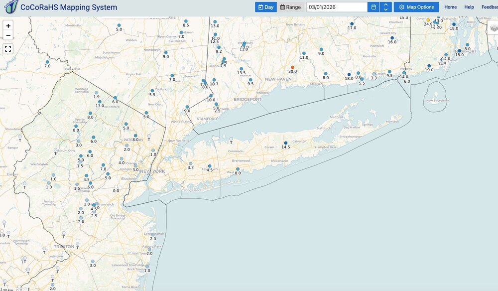
Two day storm totals. Liquid and snowfall. Click maps to enlarge.
-
Analyzed lowest pressure was 966MB. Analyzed track was about 60 miles south of the BM. Full warm seclusion.
-
https://x.com/i/status/2026316284682760389 Drone video from yesterday along the coast of Massachusetts. Pretty impressive. Photo from Westerly R.I. late yesterday afternoon.
-
So who in here plans on getting a full night of sleep tonight ? No reaching for the phone at 1:00 in the morning. No getting up at 5 to see what the 6Z NAM did. Kind of need a break.
-
Morris county comes out of NWS Mt. Holly office. Here is link: https://www.weather.gov/wrh/TextProduct?product=pnsphi
-
Wow, huge difference for such a short distance.
-
Wow. Thanks!
-
Thanks Don. What will it take for them to surpass 1978 record?
-
Final total here was 12.5". Picked up 1.5" after my 11" 7am measurement. Would have been more than that if it were a month earlier. Sun angle and temperatures near 30 were fighting against what was falling. The 1.5" was melting from underneath and compressing from the top. 12.5" is a wrap.
-
When you break 1978 records you know you are in rare territory. Especially when those records are from southeast New England.
-
Snow just won't quit even out this way. Steady light snow ongoing but skies are starting to brighten up.
-
Still light snow here. Measured 11" at 7am - water content of that was 1.08". Just about 10:1. Roughly first half of the 11 was less than 10:1 and the rest of it probably 12 or 13:1. Just an estimate, but top half of the pack was much fluffier than bottom relatively speaking.
-
Most (not all) modeling nailed the minimum pressure...to the mb actually.


