MANDA
-
Posts
2,965 -
Joined
-
Last visited
Content Type
Profiles
Blogs
Forums
American Weather
Media Demo
Store
Gallery
Everything posted by MANDA
-
Amazing photos as always Don. Really beautiful!
-
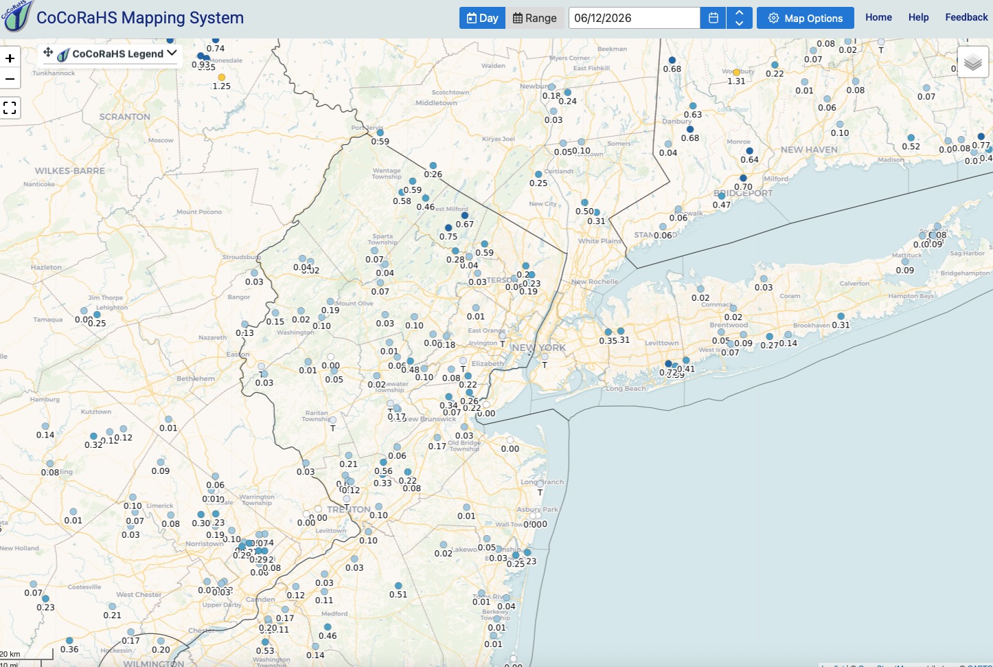
Scored .24" last evening in a T-Shower. Better than nothing I suppose. Air has better "feel" to it this morning. The humidity yesterday was foul. Cleaner air mass in place with deep blue skies. Still no Canadian smoke this season, that's a plus.
-
Missed out on any decent rainfall last night. Just .07". Additional rain chances over the next few days. Will be localized and some locations will do better than others but some heavy downpours possible in spots for sure. Another steamy day today.

-
Crashing thunder and vivid lightning display off to my north now. Just very light rain here now. The downpour lasted 90 seconds. Small storm fizzled as it past just south of me.
-
Newton / Sparta area look to be getting a good whack.
-
Same here. Getting CLIPPED by small fast moving storm just to my south. Brief heavy rain but moving through fast. Lots of lightning to my north and south with rolling thunder.
-
Much will depend on wind direction 6/21 and beyond I think. Ongoing dryness could help the heat over perform. On the other hand the lingering rather strong "cool pool" off the North Atlantic coast could temper the heat, especially along the coast if wind has any onshore component. That cooler than normal water has been persistent. We'll see if it gets beaten back in a meaningful way over the next several weeks. I would have to think it will also lessen the chances of locally intense deluges / significant flash flooding events we have seen scattered across the area over the last several warm seasons. Less moisture added to the atmosphere for our area. That area had been quite warm for the last several summer seasons.
-
After the coming trof does its thing this weekend and next week over the GL/OV it will lift out and we go full bore into summer pattern once to about 6/20. Still remains to be seen how much rain we get between now and then. Pattern could potentially produce but uncertain how far east toward our area it will get. Going to get steamy though with some higher dews than we have seen so far this warm season.
-
Starting to see signs of the "wetter" pattern around mid month. Ways to go so we'll see how it evolves but looking interesting based on some of mid to LR guidance. Could get quite steamy and soupy once to late week into next week. I like the fcst trof positioning over the GL/OV down the road. Perhaps a slow moving front draped over the east with some decent gulf moisture to work with? Details TBD.
-
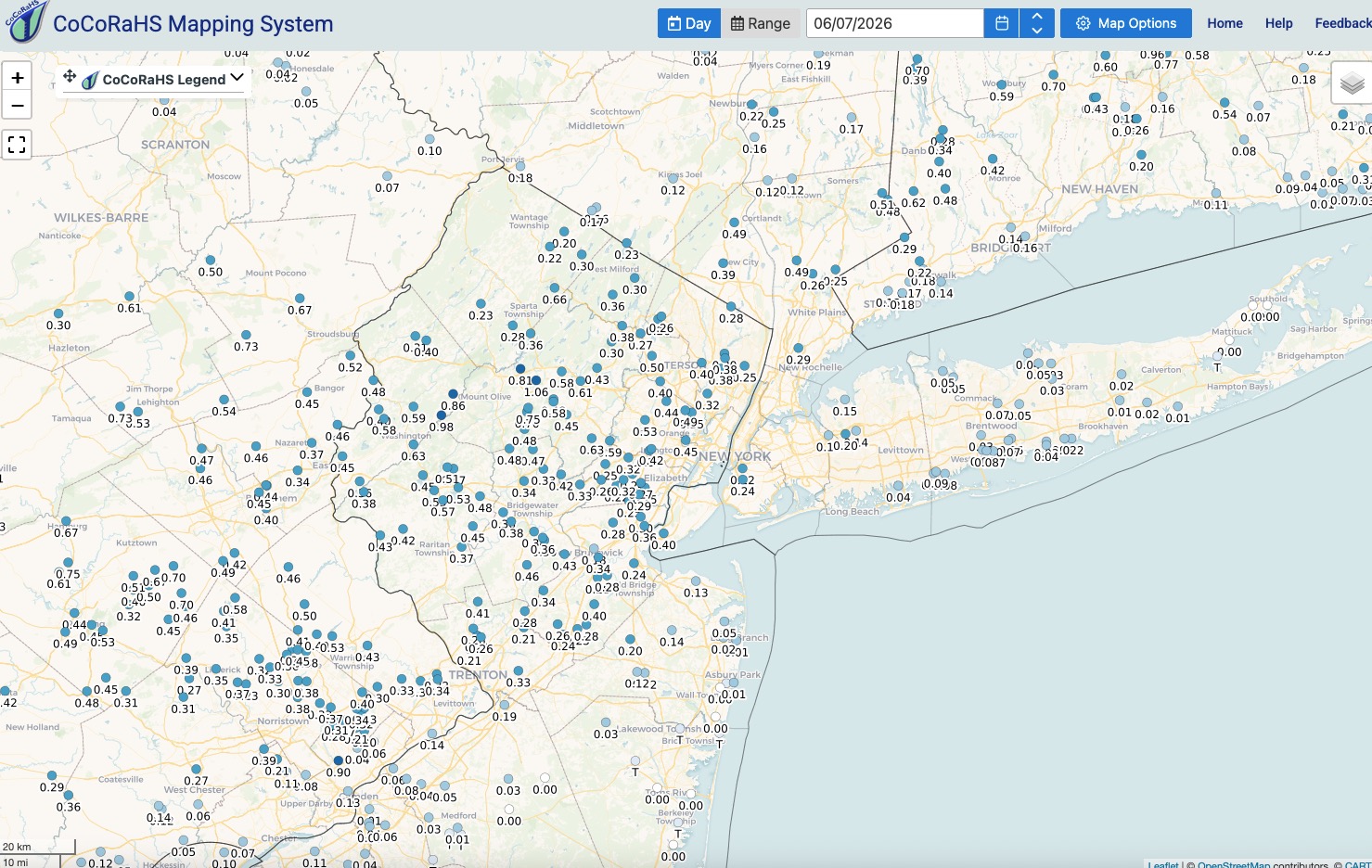
Did well here and I'm calling it a lucky over achiever on the rainfall last evening. Picked up .81". Happy about that. Lawn and garden looking happier this morning. Lawns had really started burning by yesterday afternoon. This rainfall will help a bit for a few days at least. Had a few loud booms of thunder and some vivid lightning flashes to go with the wind and rain. Estimated gusts to 40 mph but only very briefly. Great pictures you all posted from last evening. Looks like a short burst of intense heat by late in the coming week. Would love for the LR guidance to be correct about a wetter period for the second half of June with the GOM possibly opening up with a northern transport of moisture over the eastern U.S. Cautiously optimistic. Of course any northward push of gulf moisture will make it feel swampy and that will make it uncomfortable but it is June.

-
Ideal air mass and atmospheric conditions for cooler nights and rapid rises during the day. A touch more humid today as air mass gets "dirtier" and heats up but still nothing oppressive. Moderate dews at worst. Less cooling expected tonight. Minimal rainfall next 7 days at least. Watering continues.
-
Could be seeing crisping lawns by the weekend. Areas of my yard not reached by the sprinklers are already starting to crisp. The entire yard was lush green as of late last week. Flower pots in full sun and community garden bed need watering pretty much every two days.
-
I think the difference between this rain threat coming up for Sunday and the Memorial Day weekend event is that the Memorial Day weekend event brought meaningful rain. The potential rainfall this coming Sunday will be more meaningless but just enough to F up a weekend day. Looks like 1/2" or less for most spots based on the more reliable model guidance. We'll see how it plays out but it does not look overly wet IMO.
-
I'd take the February 83 renegade storm and call it a win !
-
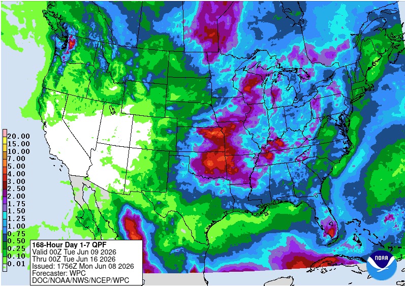
Not saying I disagree with this outlook, I don't. On the other hand I have always found these maps to be kind of useless in terms of "how much above". They say nothing for the projected departures. .5 degrees or 5 degrees? You really have to go look at EPS for the most part to get the best idea of how much above the period will be. For the sleepy general public looking at this map it screams heat wave. Just my 2 cents. I think they could do better on this product to convey the above normal message.
-
May rainfall here was 3.22". Up until the Memorial Day weekend rainfall the monthly total was only 1.29" so that holiday weekend rainfall saved the month from being extremely dry. Rainfall looks light, <.50" over the next 7-10 days for most locations. Hope everyone has a good June!
-
Sure looks that way.
-
Gotta love your optimism. We are just about at the earliest sunrise time and about 10 min to go for latest sunset so you can add that to your list of positive things. I'm not a fan of extreme heat and humidity but gotta enjoy Summer for what it has to offer. Don't rush your life away. Keep your expectations for Winter 26-27 low. Without a renegade "biggie" might be slim pickings this coming winter based on Nino climo. We'll see. Same thing for hurricane season. Looks about as hostile as it can be moving forward. Some of the longer range guidance from Canadian and EURO are BONE dry over the tropics right through August. It only takes one to make it memorable though.
-
Sampling of lowest mins across NJ this morning. Low of 43 here. So great to still be sleeping with the windows open. Back to a drier pattern again. Not much rain in sight next 7 to maybe 10 days. Thankfully no big heat either.
-
Out on a run and the moon is a rising. Chilly!
-
With 5-1/2 hours of serviceable daylight left in this 3 day weekend blue skies and sunshine have returned. Will fire up the grill later.
-
Steady light rain ongoing but looks to be last batch. Should see drying and some brightening by later this afternoon. Event total here as of 8am 1.90". Hoping to get something on the grill for dinner. Remember those who gave all this Memorial Day. My great Uncle, killed on Iwo Jima. I of course never met him. He enlisted at age 18, right out of high school and was deployed to Iwo Jima. My mother told the story of how she was visiting her grandparents in rural Teaneck, NJ. and she was sitting in the living room with her grandmother (my great uncles mother) when two marines knocked on the door with the news that he had been killed. My nephew, a marine now holds his medals and dog tags.

- 982 replies
-
- 23
-

-

-

-
They are not likely to make it up. Lots of $ lost for those folks this weekend. One of the three big summer weekends was just flushed down the drain.
-
Have to believe the bicycle stuff is due at least in part to the tough economy right now. Gas costs eating into people's disposable income? I'm sure the weather does play at least some part though. Hope things pick up for you soon.