MANDA
-
Posts
2,965 -
Joined
-
Last visited
Content Type
Profiles
Blogs
Forums
American Weather
Media Demo
Store
Gallery
Everything posted by MANDA
-
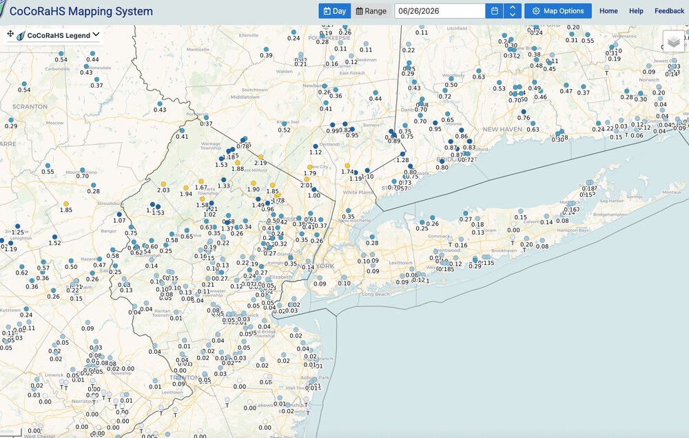
Heat kicks into high gear today and peaks tomorrow and Friday. June rainfall here was 5.51". Got lucky with a rather localized heavier total. Y.T.D. = 23.82. Some places far below these number across the metro area.
-
Came across this kind of by accident just now. This is "Earthlight" who used to be a regular and great poster on this forum. Wishing him well. Way too young for this. Jeez.
-
Was wondering the same myself earlier today. I think there was a wicked drought ongoing that summer? Someone can correct me on that if needed.
-
Congrats! Let us know how it goes!
-
Keep your expectations in check for this winter. Expect the worst and hope for the best.
-
If sea breeze can kick in right at the beach it will save the day. If west or NW flow prevents it you will cook. Friday looks like the best day to cook. Local sea breeze could save the day on Thursday and / or Saturday.
-
Rain total yesterday was .33". Total for the week was 3.88". Glad I got lucky with some heavier totals before the heat arrived. Looks like a hot stretch mid and late week. I'm thinking @MJO812 and @nycwinter will be hunkered down until further notice. Really wish CP had the instrumentation back at Belvedere Castle where it was properly sited so we could get a better sense of NYC temperatures. Thankfully we have the NYC Micronet sites across the city. CP bothers me only because that is what the media uses to give temperatures for the city and it is what people hear on new reports etc. Will be interested to see what CP tops out at vs surrounding sites.
-
Same here. Periods of rain all day from late morning until about 5:30. Over now (6:00 p.m.) Will check the total in the morning but rain all day today was not on my bingo card. It was fairly obvious through by looking at the radar this morning that a wet day was incoming across NNJ.
-
Terrible. Wish they would fix it. Takes forever to get logged in if you even can get logged it. Glad I'm not the only one having issues.
-
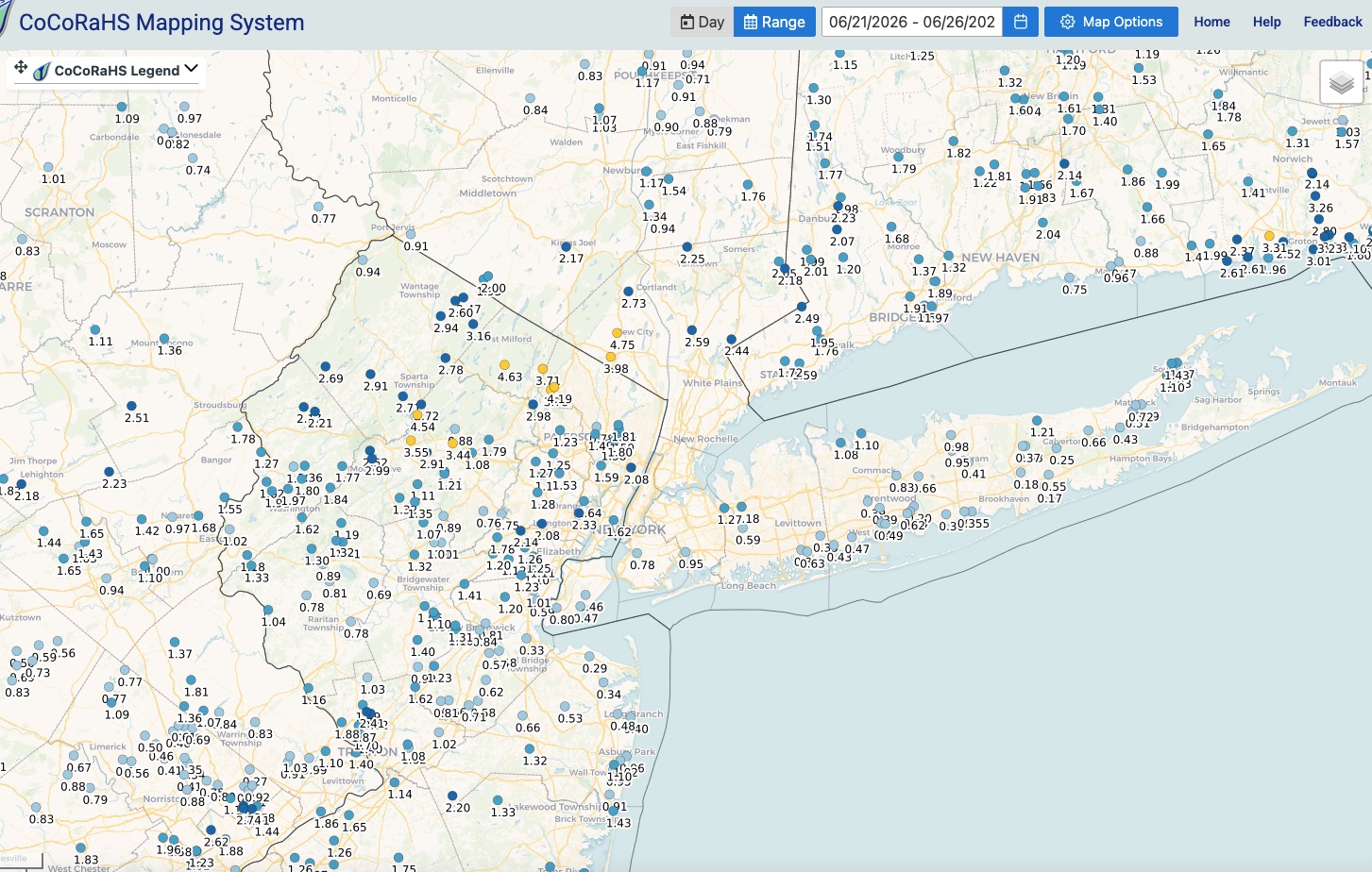
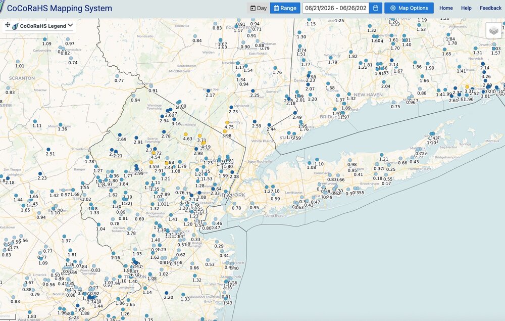
Rainfall from overnight and for the week. Click to enlarge
-
Had .63" here overnight for a total of 3.55" this week. Going to be some winners and losers in the June rainfall tallies.
-
For now at least we look to just be on the northern fringe of the heat. We'll see how that looks as we get closer. Heat looks fierce from roughly D.C. area south and southwest. Carolinas and southeast look to bake under intense upper level ridge. Maybe enough of an offshore trough to give us a slightly less hot NW flow at least initially. If ridge position is more north and east the heat will surge in but as it looks now the worst of the heat could be held at bay and only last for 2-3 days mid to late late next week.
-
Some places got more than others but beneficial rains sub forum wide.
-
Gravy on the biscuit so to speak.
-
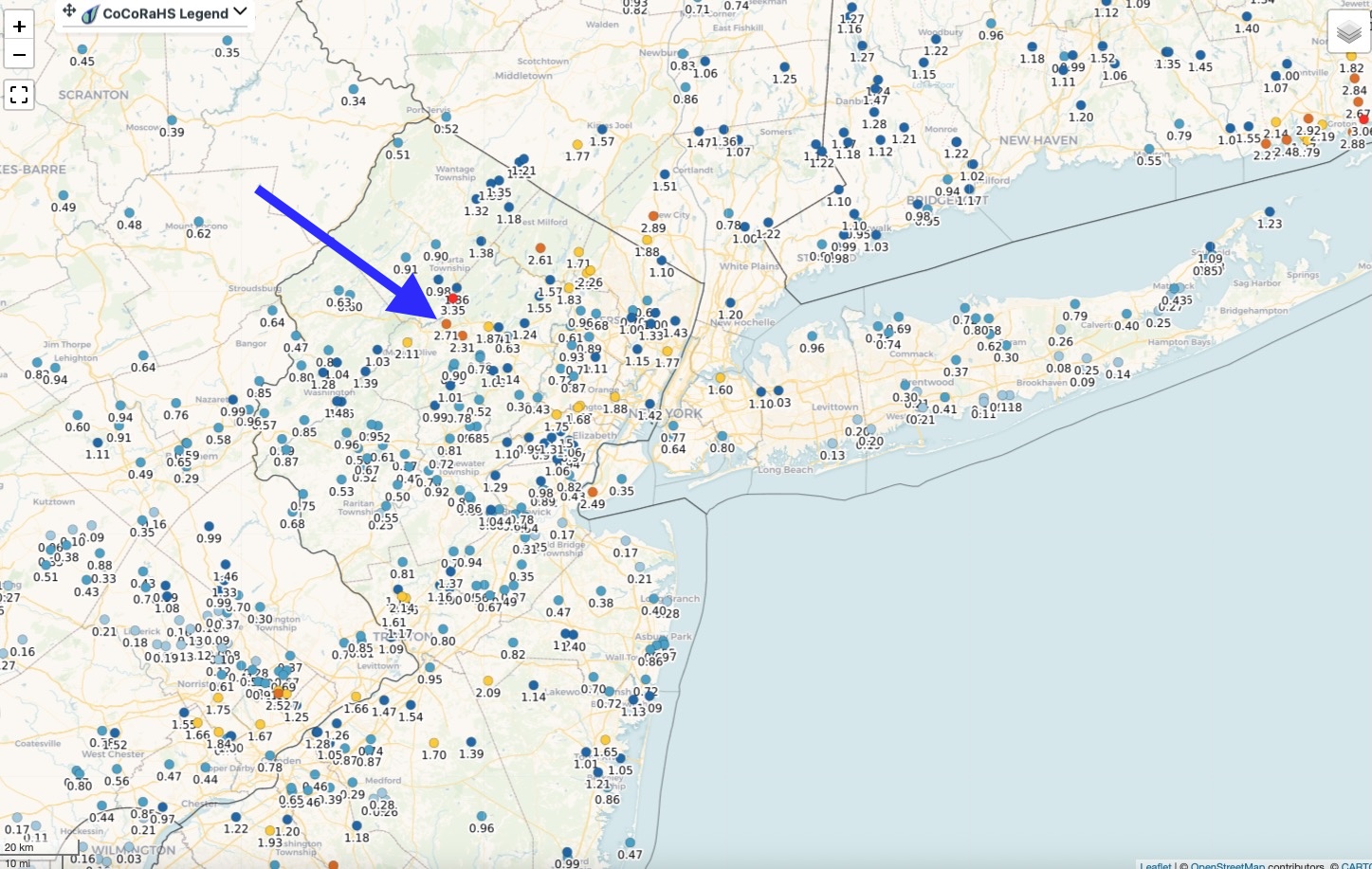
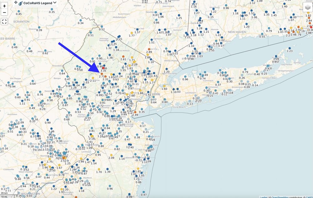
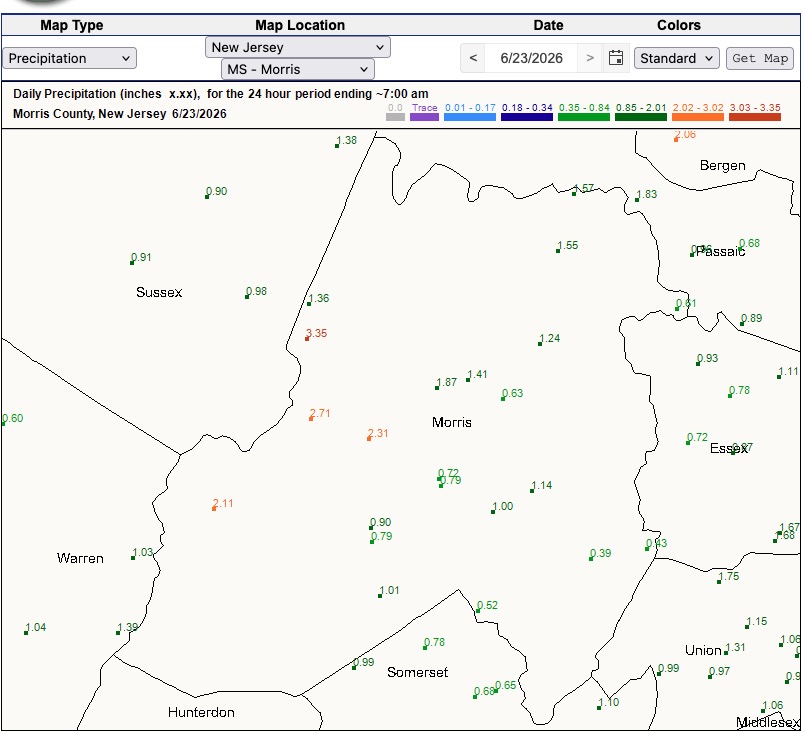
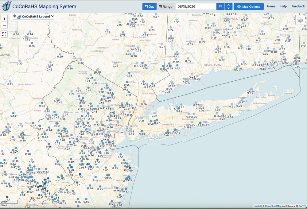
Got lucky here overnight as well. Drenched! Event total 2.71". My area was one of the places that received some of the heaviest amounts. The heaviest amounts were very localized. Click map to enlarge.
-
Fog is quite dense here. About 1/4 mile visibility.
-
Heavy downpour in progress from a very small fast moving shower. Will check the gauge in the morning but probably pushing .35” I’m guessing at this hour.
-
Nice total for EWR.
-
Just got home and pretty lame total here so far. Only .20”. Radar looks sad to my west and west-southwest. NWS doubled down on Flood Watch into early tomorrow. We’ll see I guess. Certainly not seeing anything heavy up my way for next several hours at least. CNJ looks to do best over the next few hours.
-
I'm forecasting 1" with locally higher amounts along I-78 on northward at the moment. We'll watch for subtle shifts. At a minimum I think 1/2" - 1" looks pretty solid between the I-78 - I-90 corridor. With locally higher amounts. I'll be disappointed with anything under 1". Sunny parts of the lawn not reached by sprinklers are taking it on the chin. Looking terrible. If this keeps up much longer I'm worried NJ will issue mandatory restrictions and start banning all but essential irrigation as we head through July.
-
Received .07" here last 24 hours (8am - 8am) with most of that from a very localized fast moving heavy downpour yesterday afternoon. Just some very light scattered showers so far this morning and it looks like that will be it for the day. We pin our hopes to Monday for something decent. Signal has been consistent for 1"+ so we wait and see.
-
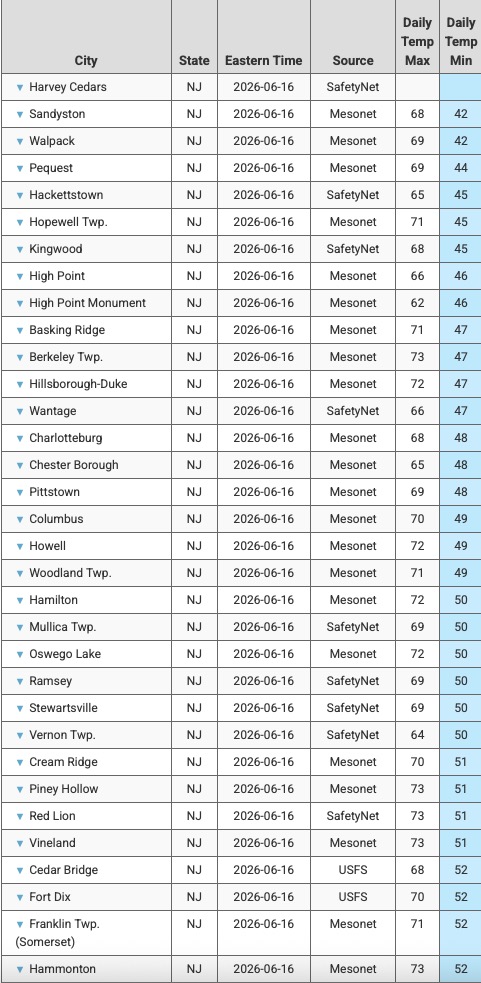
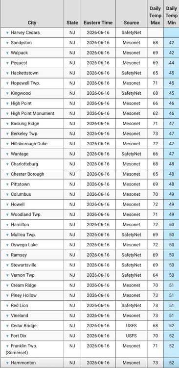
Nice weather! Not much more you could want in mid June. Enjoy! A sampling of the coolest NJ mins from this morning.
-
Received .44" rainfall overnight. Nothing remotely severe but a much needed rainfall. Received .68" last 3 days. At least I won't have to do any watering today or tomorrow. Stellar morning with low dews, pleasant temperatures, gusty breeze and deep blue skies. Click map to enlarge.
-
Yeah. Hope it is not just some gusty fast moving showers. I have a feeling it will be more along those lines with not much in the way of significant rainfall totals.
-
Hard to get the heat and humidity to hit and hold so far this warm season. It gets hot and humid for a short stretch and then it is broken but a nice air mass. No complaints from me. I had been forecasting the heat to return and hold by the end of the coming week but once again it is delayed. We'll see what the closing 7 days of June bring and then into July. Just need some rain. The long term dryness still shows no sign of breaking. We'll see who gets what later today. Was initially thinking the 7 day period ending this coming Wednesday would have been wetter with 1-2" totals fairly widespread but it is under performing. The heaviest rains have stayed west from the Mississippi River to just west of the Appalachians.