

psuhoffman
-
Posts
27,419 -
Joined
-
Last visited
Content Type
Profiles
Blogs
Forums
American Weather
Media Demo
Store
Gallery
Everything posted by psuhoffman
-
Thank you... We all have our roles to play
-
Sometimes it’s hard to accept we just can’t “know” something. But instead of focusing on the specifics we don’t know there is a lot we do. It’s very likely we’re heading towards a solid weak to moderate Nina. That also means it’s highly likely we get a suppressed STJ and an active northern stream dominant winter. Regardless of details that’s usually a dryer than normal look here. We will see a lot of those “precip hole” maps with emojis as the mountains eat up what little moisture those NS systems from the west have and they draw in Atlantic moisture too late to do us any good. We all know the drill. What we don’t yet know...is exactly the orientation and extent of the pacific ridge. If it’s flat we are very likely looking at a similar pattern to last winter. Even that doesn’t mean it AS BAD as last winter. There were some opportunities early that DC missed. And maybe there is one or two less hostile periods and DC lucks out. But it would be another very mild and likely much below normal snowfall winter. On the other hand if the pac ridge extends poleward more we will likely see more arctic air intrusions into the eastern US and while it’s still going to be a struggle without the STJ, we have a better shot of lucking into some snow and eeking close to a median winter. There is always the crazy long shot possibility that due to some factor we can’t foresee an anomaly happens. 1996 for example. Or more realistically 1999/2000! That was a god awful pattern the whole winter but we got a 10 day period with great blocking and cashed in big time. Flukes like that cannot be predicted but they can happen. That’s my take on where we are. I don’t want to stop anyone from speculating or trying to drill down on the details. I love the discussion. So don’t think I’m trying to squash it. But imo it’s risky when you drill down so much you’re using 3 seasons (And 1 of those skews the mean) to make generalizations about the expected pattern.
-
You have to be careful with those correlations. I did a deep dive into every Nina since 1950 a few years ago and found flaws in the commonly accepted correlations. Those QBO solar specific Correlations for instance are highly skewed because it’s such a small sample. Take the easterly qbo low solar. I think there are only 3 members. And 1 is 1996 which skewed the entire composite. The other 2 years were nothing like 1996! Does that mean a low solar East qbo has a 1/3 chance of being 1996? Doubt it. More likely 96 was a fluke aberration. Too small a sample to draw conclusions though. That’s just one example. What I found when I really dug into the data was there is a pretty even mix of Nina archetypes (which we discussed a month ago) determined by the location and poleward extent of the pac ridge, in every Nina category and it’s very difficult to find useful predictive markers. I did notice that having a cold sst anomaly in the northern pac was almost always a bad sign but again it was a very small sample to say conclusively it has predictive value.
-
I need to get on the payroll. Tired of sending you business for free!
-
What your data showed was that of the last 5 Nina’s with a cold October none had above avg snowfall and only 2 had median. Here is the DCA snowfall in the last 5 “non cold” October Nina’s. 13.6, 4.9, 10.1, 3.4, 7.8 None above normal snow. 2/5 median. Same probabilities. Your data is fine but all it shows is how crappy a Nina is, not any correlation to October temps as a predictor of just how crappy.
-
Post better work
-
1. There are only 5 examples there of a Nina with a cold October. Too small to be reliable. 2. You aren’t adjusting the goalposts. We know in a Nina snowfall will very likely be below avg. we’re discussing will it be in the dumpster fire type Nina or the “better” but still below avg snowfall category. 2/5 years in that set were in the better category, 15.4 and 12.8” at DCA. If DCA breaks 10” in a Nina that is a huge win. If it breaks 12” it’s dance in the street time. 15” and clothes should come off!!! You listing how all cold October Nina’s were below avg is kinda duh since there has only been 1 above avg Nina at DCA total since 1950 so it’s too small a sample to draw any conclusions!
-
I don’t disagree just saying it’s not because of persistence. My point is many of the persistence crew isn’t really about persistence they are just about pessimism.
-
But 1996 would be an aberration in any enso. How rare is that outcome just in general? I think when you get that kind of blocking all bets are off on everything else. Look at 2018. We got that kind of blocking in March and April and had several legit threats! One legit hit and a few others that would have been if it was January not March plus one storm suppressed south of us even!!! If we could get that kind of Uber blocking Dec-Feb even in a Nina we would probably do good. 2010/11 spooks some people but it still took a pretty fluky weird course of events to miss that Boxing Day storm then we did get one good storm in January. But the blocking broke down and the rest of winter sucked. If the blocking had persisted another few weeks or had been centered mid winter vs so early when our climo is rough that year probably would have been better. Anytime we get that kind of blocking it can overcome other negative factors.
-
Where’s our “persistence” crew??? I’m not saying I buy that. I don’t. But...I find it funny that our resident persistence worshipers that like to tell us the crap pattern will continue because....persistence...are suddenly saying “but it won’t last” when the pattern is good.
-
I agree there is still hope this year ends up in the “better” Nina category. When I examined past Nina archetypes I found it very difficult to determine reliable predictive characteristics we could use ahead of time. The one would be extremely cold north Pac SST (Which almost always was a kiss of death) but we don’t have that. Unfortunately some still ended up crap anyways. But there is hope! However...notice most of even the “better” colder Nina Years were still more frustrating than not. 1996 aside the rest still ended up below avg in DC. But they did get closer to median and at least had chances in the area and legit threats to track and some places in our region did better in some of those years. So they are “better”. But it’s wise to set the bar pretty low in a Nina. Even a “good” Nina is simply getting anywhere close to avg. A median snowfall winter is a huge win in any Nina imo. If we get super lucky and 1996 decides to repeat itself great. But I’ll save my sanity not counting on that.
-
October snow is way too small a sample size to draw firm conclusions Thats like if some minor league player got called up for one game and hit 1/3 thinking they will bat .333 for their career!
-
Agree with all this. But what I found (and most know) is in a Nina it’s even harder to luck our way to a significant snow without any HL blocking. A lot of that is due to a less potent stj. Without blocking in any regime our best shot is to luck into a juiced up but progressive wave. Those are really unlikely without any stj help. But that is especially pertinent to DC. They are too far west to benefit from waves that develop late as they infuse Atlantic moisture. DC needs the gulf as it’s main moisture source. Only exception is a slow moving amplified bomb. But we need blocking for that so again catch 22! So it’s REALLY difficult for DC to get a significant snow in a +NAO Nina regime. Even more so than in other enso states.
-
There is a quote from prince’s bride that works here
-
I just figure when most people outside our region want a quick snapshot they are focused on the urban corridor from DC-Baltimore. You and I are not really in the mainstream here. 2000 wasn’t that good up here (but I would take it) since it’s a lot harder to fluke to avg with a couple storms up here. But the “we” was for the main cohort in this forum. You can get clipped by late developing miller bs and coastal scrapers much easier and in a Nina that advantaged your area over DC sometimes.
-
We did pretty well in 2000 by our standards but all the snow fell in 2 weeks when there was blocking. The rest of the winter sucked. We can always root for a fluke like that. Actually, A few years ago heading into the 2017 nino I went back and examined the h5 look leading up to every Nina warning even at BWI going back to 1950. Every single one had some kind of high latitude help. In some cases it was bootleg and didn’t show up well on the numerical NAO. Like blocking near Hudson Bay which is actually one of our better ways to back into a snow event in a flawed longwave pattern here. But I couldn’t find a single significant Nina snow without at least a decent look up top to aid. If the NAO looks like hot garbage in a Nina we can try to luck into some kind of scraps like a front end inch or two or a clipper but we’re not getting anything of substance.
-
But did you say it with a Monty python French accent?
-
Agree, 2011 was very close to a mini 1996 type Nina repeat just got really unlucky. Even the one good storm could have been much bigger if it hadnt come when the cold was stale and we wasted the front half of the storm.
-
2010 wasn’t a typical Nina fail. It wasn’t a late developing northern stream system. It was a big snow in the TN valley and NC with plenty of gulf moisture. But if I remember correctly a couple details screwed us. The upper level low was really broad and the base of the trough dug a bit too deep them swung around too wide right for us. On top of that there was a weak northern stream wave that came across right in front of it that may have helped to initially suppressed the gulf system until it was too far east to help us.
-
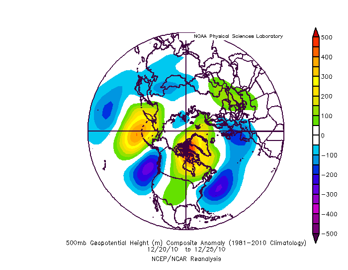
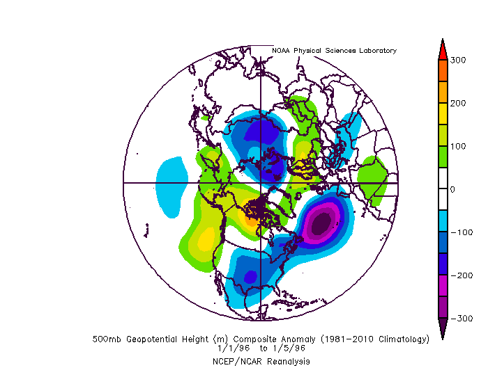
comparing the week leading up to 1996 and 2010 the pure high lat block was better in 2010. The blocking in 1996 had weakened some and shifted centered west of Hudson by January. But what made that work was the monster ideally located 50/50 low and that the trough axis was perfect just to our west and centered far enough south to get some stj involvement despite the Nina. Very rare. 2010 the blocking was better but a less ideal trough axis and 50/50. But it still could have worked except there was a weird messy phase between the initial gulf wave and the NS that initially suppressed the wave to our south then pulled into the NS too late for us. It could have ended better with better timing. Problem is we need more to go perfect here being further southwest than Philly-Boston.
-
I know, and I know you know everything I’m saying. Just adding not refuting anything!
-
There are macro level patterns that are conducive for snow here. But within that there are micro level details that can determine hits v close misses. I could show you some big hits and near miss h5 plots and you couldn’t tell the difference! Chaos has a hand in this. That said Nina’s tend to be an issue because the stj is suppressed and it’s NS dominant. And that means 2 issues. Most storms, even with blocking, are later developing because they usually are cut off from deep moisture until they hit the coast. As the Furthest west of the northeast regions that disadvantages us. Second it’s hard to get the NS to dig under us enough. As the furthest south of the typical snow regions...you get the idea. So Baltimore has a marginally better shot that DC. Philly marginally better than Baltimore. NYC better than Philly and by the time you get to Boston Nina’s often are awesome there! But you aren’t going to pick up on any of the micro level details that determine Jan 1996 from Dec 2010 from any kind of range.
-
Him! I almost made a similar reply to yours then stopped myself thinking...why am I going to stop to respond to the crazy guy screaming on the street corner soap box?
-
We know day 15 scores are barely better than climo. So not shocking day 100+ is erratic and unreliable. But the models are based on sound physics. Despite what DT says they don’t show things that are physically impossible. Improbable maybe but not impossible. So what these random runs that show a colder winter paradigm say is that yes that outcome is still within the envelop of possibilities. We all know what what the likely outcome is given our Nina climo. But still within the Nina set are anomalies (1904/5, 1910/11, 1917/18, 1995/96). And we don’t have a really good predictive answer for them. If you showed me all the data from early fall 1995 I wouldn’t have expected that. And I think sometimes the desire to figure it out leads to prescribing too much significance to one factor. Yea the QBO was going negative but we have had other Nina’s with a similar qbo that didn’t lead to that outcome. I think sometimes people are uncomfortable with uncertainty and just admitting “we don’t know”. Odds favor the typical dud Nina. But maybe come March we are looking back wondering how no one saw that coming!
-
If I was walking down the street and some stranger said some crazy nonsense like that I would just keep walking. I think I need to live my internet life more like that...


