psuhoffman
-
Posts
27,419 -
Joined
-
Last visited
Content Type
Profiles
Blogs
Forums
American Weather
Media Demo
Store
Gallery
Everything posted by psuhoffman
-

The Weekend Rule? Saturday 2/17 - The Icon Storm
psuhoffman replied to DDweatherman's topic in Mid Atlantic
You said NEVER… 12z gfs
-
The Weekend Rule? Saturday 2/17 - The Icon Storm
psuhoffman replied to DDweatherman's topic in Mid Atlantic
full fluff factor -
The Weekend Rule? Saturday 2/17 - The Icon Storm
psuhoffman replied to DDweatherman's topic in Mid Atlantic
31/21 Sn+ -
The Weekend Rule? Saturday 2/17 - The Icon Storm
psuhoffman replied to DDweatherman's topic in Mid Atlantic
You must of slept through the 12z run today. NAM/GFS/Euro all had over 4” for a large part of the area. -
The Weekend Rule? Saturday 2/17 - The Icon Storm
psuhoffman replied to DDweatherman's topic in Mid Atlantic
That one screwed me over in State College too! -
The Weekend Rule? Saturday 2/17 - The Icon Storm
psuhoffman replied to DDweatherman's topic in Mid Atlantic
Glad I’m not in Pine Grove anymore. Look at that subsidence just north of that band. That’s going to be the real screw zone. -
The Weekend Rule? Saturday 2/17 - The Icon Storm
psuhoffman replied to DDweatherman's topic in Mid Atlantic
That happened to me once. Growing up in NJ. Watched this band of snow coming east from PA but it never made it. Front end started to dry up as the front advanced until the back edge caught up to the front end like 1 mile from me and the whole thing dried up. -
The Weekend Rule? Saturday 2/17 - The Icon Storm
psuhoffman replied to DDweatherman's topic in Mid Atlantic
Some of the hills in the Lebanon area are candidates for the 8”+ jack zone. -
The Weekend Rule? Saturday 2/17 - The Icon Storm
psuhoffman replied to DDweatherman's topic in Mid Atlantic
I can tell from how it’s accumulating so far ratios here are way over 10-1. Very fluffy. Excellent dendrites. -
The Weekend Rule? Saturday 2/17 - The Icon Storm
psuhoffman replied to DDweatherman's topic in Mid Atlantic
Y’all weren’t kidding that was fast. Went from nothing to heavy now in 10 mins. Grass has a coating and parts of the driveway are caving. 32/19 -
The Weekend Rule? Saturday 2/17 - The Icon Storm
psuhoffman replied to DDweatherman's topic in Mid Atlantic
It’s over there that’s the back edge -
The Weekend Rule? Saturday 2/17 - The Icon Storm
psuhoffman replied to DDweatherman's topic in Mid Atlantic
Unfortunately that’s the band I was hopeful we could get under a couple days ago. But that’s been gone for a while. Now I’m just praying I don’t end up in the subsidence between that band and the fgen associated band to the south. -
The Weekend Rule? Saturday 2/17 - The Icon Storm
psuhoffman replied to DDweatherman's topic in Mid Atlantic
Mid levels were perfect for snow growth -
Oh I had that duel banding structure in my forecast. I buy that. It’s the general drying at the last minute in less sure of. There will be winners and losers based on meso scale banding though.
-
Here is the actual exchange, then you don’t have to stand by anything, everyone can see for themselves.
-
That’s fine but the people here have the right to know the truth. They can go read the other thread and see for themselves that you’re lying.
-
The trends are what they are but the storm had been over performing in many locations to our west. And I’ve noted several times over the years when guidance pulled this drying up thing right at the last minute and it was wrong. We will know real soon.
-
If you’re going to reference my post please quote or link it so people can see for themselves. You’re misrepresenting what my exchange with chuck was about. He criticized the NWS not my forecast. The NWS went higher than me. But I felt his attack was unfair. He made several inaccurate statements. He was trying to make a case they had no justification for their high snowfall forecasts and denied models are trending lower with qpf. The NWS made those forecasts this morning based on 12z data that at the time was averaging around .5qpf and trending upward. It’s not fair to use information that came out after they made those forecasts to call them unjustified. He also inexplicably twice claimed guidance never showed more qpf then when I called him out and showed the trends he blew it off and switched to other arguments. Chuck can be brilliant. He can also be infuriating at times. And just because he has issues doesn’t mean he gets to attack someone with misrepresentation or flat out lies and not get called out. Lastly we go back and forth a lot. We have a rapport in the other forum. We often argue but it’s not hostile. I respect him but in this case he was wrong and misrepresenting things in a way unfair to NWS.
-
The Weekend Rule? Saturday 2/17 - The Icon Storm
psuhoffman replied to DDweatherman's topic in Mid Atlantic
34/17 waiting. Radar looks good to me. -
The Weekend Rule? Saturday 2/17 - The Icon Storm
psuhoffman replied to DDweatherman's topic in Mid Atlantic
The storm has been over performing to our west. Makes no sense. I’m skeptical. -
The Weekend Rule? Saturday 2/17 - The Icon Storm
psuhoffman replied to DDweatherman's topic in Mid Atlantic
I live on Dug Hill! -
The Weekend Rule? Saturday 2/17 - The Icon Storm
psuhoffman replied to DDweatherman's topic in Mid Atlantic
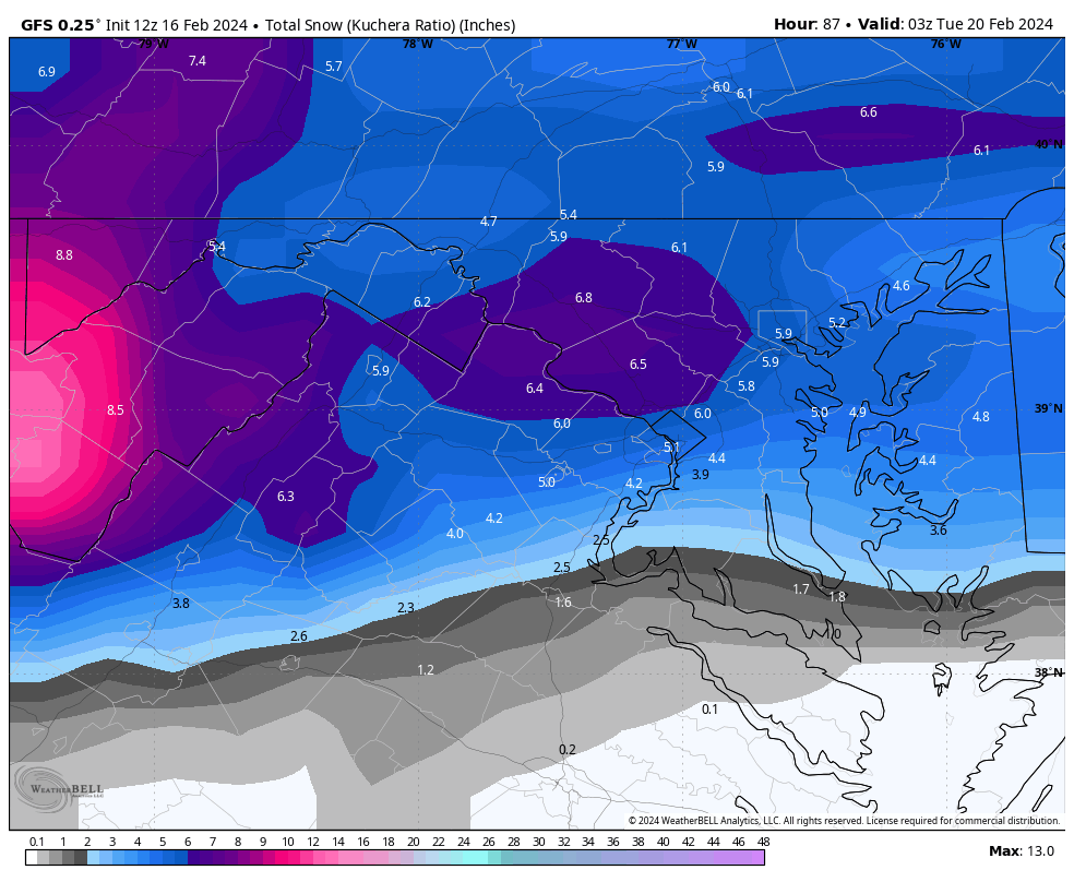
-
The Weekend Rule? Saturday 2/17 - The Icon Storm
psuhoffman replied to DDweatherman's topic in Mid Atlantic
-
Late Feb/March Medium/Long Range Discussion
psuhoffman replied to WinterWxLuvr's topic in Mid Atlantic
The euro weeklies did. The EMON plots ran through 8/1/2, mostly at low amp but they did back when they looked amazing.