

psuhoffman
-
Posts
27,419 -
Joined
-
Last visited
Content Type
Profiles
Blogs
Forums
American Weather
Media Demo
Store
Gallery
Everything posted by psuhoffman
-

What Went Wrong in Winter 23-24/Base State/Will It Ever Snow Again??
psuhoffman replied to WxUSAF's topic in Mid Atlantic
December did have more a canonical nino pattern, which is why early on I was still very optimistic for the winter despite the snowless early returns. The problem is in a strong nino December is typically warm/snowless anyways. The only exceptions are weaker or modoki nino's where the pacific trough is displaced west of normal for a nino and so we get a better PNA ridge. Even in the past it's always been difficult for us to overcome any deficiencies in the pacific until January. Our snowfall in December is more highly correlated to getting BOTH an ideal Atlantic High latitude AND pacific patterns. If you look at all the strong nino analogs even on the snowier side of the list...1958, 1966, 1987 and 2016, none had any snow in December except 1958 which had one fluke snowstorm in an otherwise torch month. The others were all snowless and warm. The issue is when the nino would have helped us it decoupled some in January. It ended up kind of a hybrid with both nino and nina tendencies. The stronger than normal ridging west of the nino trough was an issue. It continually pushed the nino trough east of ideal. The nino trough was NOT out of control like 1973 and 1998. It was not nearly the strength of a super nino trough. But it was displaced east so that it had the same impact on our pattern because of the nina like ridging further west in the pacific. We got a half and half winter, the problem is we got the worst half of both a nina and nino! Yay us. -
Late Feb/March Medium/Long Range Discussion
psuhoffman replied to WinterWxLuvr's topic in Mid Atlantic
And it induced this long wave pattern. The mjo can’t do anything about the fact the surface temps torched right through this period anyway.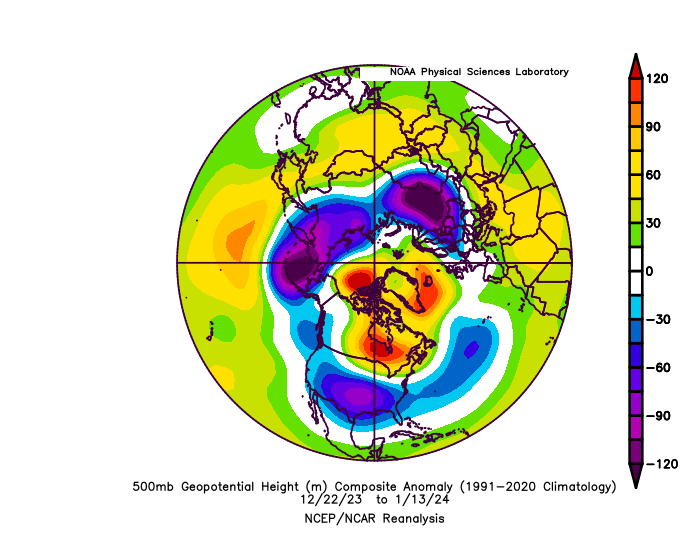
-
Late Feb/March Medium/Long Range Discussion
psuhoffman replied to WinterWxLuvr's topic in Mid Atlantic
I mean this a long range discussion. Just super duper long range. -
What Went Wrong in Winter 23-24/Base State/Will It Ever Snow Again??
psuhoffman replied to WxUSAF's topic in Mid Atlantic
I’ve read that the reduction of SO2 may have increased warming due to increased sunlight. But is there evidence it’s somehow contributing to the PDO? If so isn’t that extremely bad since we’re establishing a -pdo has become pretty hostile to snow here and that seems like a more permanent thing! -
What Went Wrong in Winter 23-24/Base State/Will It Ever Snow Again??
psuhoffman replied to WxUSAF's topic in Mid Atlantic
The persistent AK trough is also not very Nino ish. That’s more a weak Nina or neutral after a Nina look. -
What Went Wrong in Winter 23-24/Base State/Will It Ever Snow Again??
psuhoffman replied to WxUSAF's topic in Mid Atlantic
It failed similarly but for different reasons. 98 the Nino pac trough was a beast and extended east because the Nino was very easy based and strong. This year the pac trough was weaker, more in line with a typical Nino, more transient but it kept getter pushed east by Nina ish central pac ridging and displaced into the pna domain. -
if he still has the same habits...right before he finally capitulates he will go silent for a while...a day or two will go by with no posts or videos...and then he will issue an angry incoherent crazy rant about how he put so much work into it and this or that just didn't go right and you have to be humble and god this and god that and how grateful he is for his family as if the MF just went through some personal tragedy.
-
Late Feb/March Medium/Long Range Discussion
psuhoffman replied to WinterWxLuvr's topic in Mid Atlantic
I’ve given up on anything much in this -pdo. Yea we will keep getting some snow. Table scraps. But this is it. But can you imagine if this continues after the PDO flips? We better get a snowy winter quick after the PDO goes positive or it will be real depressing. -
What Went Wrong in Winter 23-24/Base State/Will It Ever Snow Again??
psuhoffman replied to WxUSAF's topic in Mid Atlantic
Here are some things I have thoughts on...some of them I agree with you on, some I do not. I'm trying to have a cordial friendly conversation though. No need for the hostility just because I missed one of your posts a few days ago. Stop looking at weather through a microscope. It does not enhance the resolution but rather blurs it. 5 miles by 5 miles is more than enough of a close up, really 10x10. The closer up you zoom that more the errors rapidly multiply.. If you are referring to NWP here and the tendency for the globals to increase resolution, especially the euro lately, I agree. As they have increased resolution they have increased variability. The are technically more accurate now globally. But they can be inconsistent run to run and with less predictable biases. For me, in some cases, they were easier to use before the resolution increases. They might have biases and be off but I could predict how they were off and adjust for them. That made them more useful than when they go off on tangents run to run. But they sacrificed consistency at longer leads for being able to better model details at shorter leads. Wasn't my choice. Go with less calculus and more AI stipulated analog composition There are attempts at this right now, but they are new and it will take a little time to develop. I've been following some of the AI models and they have not been awful, especially considering how new they are, basically first generation. They have had some successes. But they have had some bad failures too this winter. They were still holding onto the storm for later this week for instance for days after the old school models realized it was going to be way too warm. I hope they can develop this tool, I have absolutely no issue with using AI analog based methodology, it just wasn't available until now. I do use analog forecasting when a threat is upon us. I look at the CIPS analogs all the time and they inform how I adjust what the models are showing in my forecasts. Begin to consider that earthquakes,volcanoes and huge tidal waves actually may have shifted things in some way. Lord knows plenty buy into gas stoves and cow farts as our ruination and the things I mentioned are 20,000X stoves and cows. I don't have the resources to research any of that. I can read the research others are doing though. As of yet no reputable study has found a significant long term influence from any of those factors except one...the cows lol. I didn't do any of that research. But I balk at two things... the idea that climate change is some politically fueled agenda is first. The research showing warming was done before there was politics about it. The politics came later as different parties took sides and money interests aligned itself with those sides. IMO some are putting the cart before the horse here. The other issue I have is that we have to consider every possible theory before they are proven. That is not how it works. When someone comes up with a new theory that goes against the status quo it is up to them to prove it. The burden of proof is on the person proposing a new theory. We don't start from a place of every possible theory is true until you disprove it. So I have no first hand knowledge that the 32" change in the Earths axis during our lifetime has or hasn't changed our climate. But I've seen absolutely no evidence or study proving that it has and so until that evidence is provided the status quo is that it hasn't. I am willing to consider it has. If someone conducts a study that proves it has, I can accept that. But you seem to be asking me to accept these possibilities without any proof. I don't think incorporating unproven speculation about every possible theory into my forecasts will increase their accuracy. How would I even do that? Ive seen nothing about how these things impacted climate in a tangible way. So back in October when I was formulating my winter forecast exactly how could I have incorporated the change in the Earths axis or tidal waves? Is there some research saying how I could adjust our snowfall climo for these variables that I have not seen? If I am missing something I am open to seeing it and considering it. Ditch the 7+ . A lot of extended weather is corrupted for agricultural and oil futures advisements so are you saying you're not going to issue seasonal forecasts anymore? My question was about how to make long range analysis better and you pretty much said "don't do it". That isn't getting better that's giving up. I want to get better not give up. This seems to imply your problem is that the long range thread exists at all. You don't want us to improve on it you want us to get rid of it? If so...why not just not go in there and then for you it doesn't exist and others that do want to discuss long range can do so? Honest question. -
Late Feb/March Medium/Long Range Discussion
psuhoffman replied to WinterWxLuvr's topic in Mid Atlantic
You’re right. Next year we get 2017 followed by 2002. -
Late Feb/March Medium/Long Range Discussion
psuhoffman replied to WinterWxLuvr's topic in Mid Atlantic
If the PDO flips by next fall I will entertain that maybe a 1996 anomaly is within the realm of possibility. But that has no chance in this current pacific base state. -
Late Feb/March Medium/Long Range Discussion
psuhoffman replied to WinterWxLuvr's topic in Mid Atlantic
I get what you’re saying but there hasn’t been a single snowy anomaly out of 6 chances. And the pattern is pretty consistent not like a mean from different variable anomalies. It’s possible we just got unlucky 6 straight times but I doubt it. Also, the pattern fits a logical explanation. I can see the why behind the what even if there isn’t enough data to prove it with statistical significance yet. -
Late Feb/March Medium/Long Range Discussion
psuhoffman replied to WinterWxLuvr's topic in Mid Atlantic
I think they updated last year. Ya you have to adjust for climo changes. This is the mean of we remove years prior to 1990. The only place it’s cold is where we don’t want it to be lol.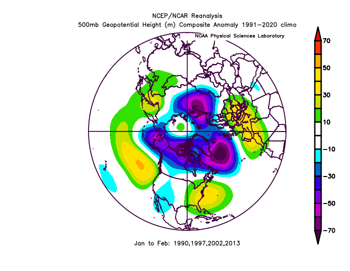
-
Late Feb/March Medium/Long Range Discussion
psuhoffman replied to WinterWxLuvr's topic in Mid Atlantic
Those plots use 1990-2020 climo means though. -
Late Feb/March Medium/Long Range Discussion
psuhoffman replied to WinterWxLuvr's topic in Mid Atlantic
It looks colder because several of those years are from a colder period. That’s all imo. The biggest take away between that and the Nina h5 is there tends to be a flatter pac ridge and a more +AO. But that correlates. A poleward ridge can lead to heat fluxes that weaken the TPV and can foster blocking. In a flat pac ridge the faster flat jet actually speeds up the TPV and precludes blocking. -
Late Feb/March Medium/Long Range Discussion
psuhoffman replied to WinterWxLuvr's topic in Mid Atlantic
@SnowGoose69 here is the Jan/Feb composite h5 for all neutrals following a Nina. let me vomit. We’d be way better off with a stronger Nina ridge than that puke there! Last year we had some discussion that last winter behaved more like a neutral after a Nina and looks a lot more like that comp above than the Nina comp with a stronger pac ridge. The Nina was very weak and fading by winter.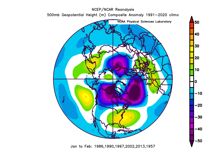
-
Late Feb/March Medium/Long Range Discussion
psuhoffman replied to WinterWxLuvr's topic in Mid Atlantic
I can’t always prove the why behind the what. I can simply find statistical correlations. In the last 40 years our snowfall in enso neutral following nina years has been the worst category. Worse than Nina’s and other neutrals and obviously ninos. My only theory as to why is a weakened Nina lag. In an actual Nina sometimes the pac ridge can be poleward and in those cases we can get cold and some snow. It’s still northern stream dominant so big mecs+ level storms are rare south of 40* and it’s hard for us to go above avg without any big storms but at least they aren’t awful winters with near median snowfall. I think in a neutral with a Nina lag we seem to get a weaker flat Nina pac ridge (like what’s coming the next 2 weeks) and that’s the worst often with a trough to its north over AK! We get a continent flooded with warmth AND an eastern ridge. Shit the blinds pattern for any snow chances south of Montreal. We would be better off with a stronger Nina response and perhaps a poleward ridge at times. -
What Went Wrong in Winter 23-24/Base State/Will It Ever Snow Again??
psuhoffman replied to WxUSAF's topic in Mid Atlantic
Not everyone follows daily. When they come in and comment not knowing about this thread people invariably reply there. That’s what happened today. And CC is extremely linked to discussing long range patterns since one impacts the other so it’s somewhat unrealistic to expect no cross pollination of conversation. What I don’t get is I don’t see this reaction anywhere else. Both in some of the other regional forums I participated in and on other weather based science boards. It’s only here that people go berserk when CC gets brought up in a thread about predicting weather. Other than the politics of it, and I’ve reached a point where IDGAFF about that I’m 100% focused on the science and weather people can shove their politics up their u know what. -
Late Feb/March Medium/Long Range Discussion
psuhoffman replied to WinterWxLuvr's topic in Mid Atlantic
Underwater volcanoes -
Late Feb/March Medium/Long Range Discussion
psuhoffman replied to WinterWxLuvr's topic in Mid Atlantic
Unfortunately my research shows there is a lag time wrt fading la nina patters. There is absolutely no evidence that a La Nina that fades towards neutral during the winter produces an increase probability of snow later in winter here. In actuality, the Nina's that fit that category had lower snowfall in Feb/March than La Nina's that did not fade. Snowfall can be a fluke so I also looked at the H5 patterns, and saw no evidence the canonical Pacific La Nina pattern was more likely fade late in winters where the La Nina faded. I can accept what you are saying about a fading El Nino might be true. Perhaps an el nino patter breaks down faster and there is no lag. But there have been examples of fading el nino's where the canonical nino pac didn't break down until well after the nino SST's did. I would have to look into it more to try to understand the why behind the what. ETA: Also...there is some evidence that a neutral following a nina is even worse than a nina. So that might explain why a fading nina does us no good. -
What Went Wrong in Winter 23-24/Base State/Will It Ever Snow Again??
psuhoffman replied to WxUSAF's topic in Mid Atlantic
@WEATHER53 also, the best way you can make your point is to discuss your analysis and show the better way you think is out there to analyze and predict long range patterns. I want to get better. If there is a better way than the current analog based methods I use I’m open to it. But vague criticism with no productive suggestions is unhelpful. Even if I wanted to act on your posts what exactly can I do? You’ve provided no tangible suggestions. -
What Went Wrong in Winter 23-24/Base State/Will It Ever Snow Again??
psuhoffman replied to WxUSAF's topic in Mid Atlantic
Personally I’m discussing what happened so that I can understand what mistakes I made and not make them again. If I don’t analyze what caused the non canonical Nino pattern then I can’t improve my forecast next time we’re faced with a similar scenario. -
What Went Wrong in Winter 23-24/Base State/Will It Ever Snow Again??
psuhoffman replied to WxUSAF's topic in Mid Atlantic
Yea but it has the trough north of Hawaii making it sort of a hybrid and that blocking. I’m not holding my breath we see either next year. But flukes happen. And all we need is to get lucky in a short window. Most remember 2000 fondly but other than 10 days the winter was an awful long wave pattern. Look at this mess…and yet we remember it as a good winter. A fluke like that could happen But we hit 3/3 on waves in those 10 days. It’s possible but odds are against us.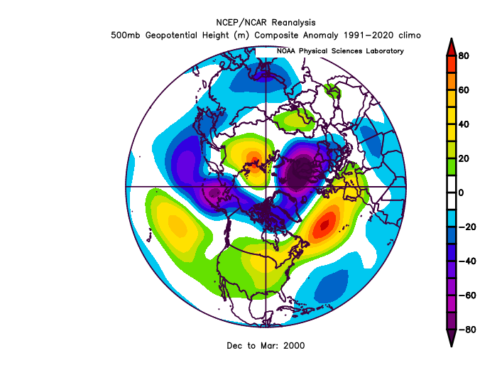
-
Late Feb/March Medium/Long Range Discussion
psuhoffman replied to WinterWxLuvr's topic in Mid Atlantic
Done -
What Went Wrong in Winter 23-24/Base State/Will It Ever Snow Again??
psuhoffman replied to WxUSAF's topic in Mid Atlantic
@brooklynwx99 Moved from other thread.. There are several factors that are all contributing imo. The warmer waters in the western PAC and IO are favoring hostile MJO forcing. The Hadley cell has been expanded lately displacing the jet in the central pacific north. This might also be contributing to the over extensions as the compressing of the jets speeds them up. The warmer waters all around the enso regions are muting the impact of ninos and enhancing the impact of Nina’s by muting and enhancing the temp contrast. There was good research that suggested the contrast is more important than the raw enso anomalies. Lastly this PDO cycle is on roids and bullying other influencers right now. They are all working in tandem to create an extremely hostile base state that’s destructive to attempts at establishing a canonical Nino. Sometimes one might relax, like the mjo right now. But taken holistically as a whole I think it’s just too much for the Nino to overcome for more than short sporadic periods. We knew this, it was discussed as the reason for the 2019 Ninos failure to couple with the atmosphere. But most of us thought a strong bordering on super Nino would overcome those obstacles. Simplest answer is that it was not. There were some voices out there warning this would happen. I acknowledged this was a risk. But I went with the belief the Nino would win. I was wrong. Some of those factors are most definitely related to warming. Some most definitely are just cyclical like the PDO. Others it’s unknown whether they are CC or a temporary thing. We won’t know, imo, how bad off we are until the PDO flips. What I think we’ve proven is that all those other factors have conspired to make a -PDO worse and pretty much impossible to get a cold snowy winter in the mid Atlantic south of 40. But there is no evidence yet that +PDO have been affected. 3 of the last 5 +PDO winters were above avg snow here. But none were after the 2016 super Nino that might have reset things to a degree. But since we’ve been in a strong -pdo since 2018 all we can do is speculate. 2017-2018 was too small a sample size but to be fair both were typical Nina’s and cold at times. Nothing in those years struck me as alarming. That started happening in 2019 on when the PDO went Uber negative. So I’m hopeful that while our -pdos have been rendered god awful by other influencers exasperating what was already a hostile cycle, once we get a +pdo we can still cook wrt snow. We will find out when the PDO flips


