-
Posts
27,417 -
Joined
-
Last visited
Content Type
Profiles
Blogs
Forums
American Weather
Media Demo
Store
Gallery
Everything posted by psuhoffman
-

Late Feb/March Medium/Long Range Discussion
psuhoffman replied to WinterWxLuvr's topic in Mid Atlantic
Ya not sure March 58 would even be a snowstorm anymore. Not kidding. -
I got the thunder and the precip. Just missed the temps. Meatloaf said…
-
See I told ya my storm would be epic. Thunder. Lightning. Heavy precip. Massive communications disruptions.
- 374 replies
-
- 10
-

-

-

Late Feb/March Medium/Long Range Discussion
psuhoffman replied to WinterWxLuvr's topic in Mid Atlantic
-

Late Feb/March Medium/Long Range Discussion
psuhoffman replied to WinterWxLuvr's topic in Mid Atlantic
But @Terpeast said that would probably just be a perfect track rainstorm now -

Late Feb/March Medium/Long Range Discussion
psuhoffman replied to WinterWxLuvr's topic in Mid Atlantic
@CAPEThe GEFS and op Euro are really going stronger with the Scandi ridging by day 10 or so... Look I am still in the skeptical camp that any of this leads to snow for us...but its worth noting that's all. If the heat flux from the Canada ridge and the Scandinavian ridges combine to cause a -NAO, that is not an uncommon progression in a strong nino. It's coming a little late for us here though. Honestly, my WAG is that we do get blocking from this...but that it comes too late for snow...and just in time to give us a miserable March 20-April 15 or so....by late April it won't matter on a sunny day we will warm up regardless of blocking. Who cares what its doing on a rainy day, I'm not chillin outside in the rain whether its 65 or 45. -

Late Feb/March Medium/Long Range Discussion
psuhoffman replied to WinterWxLuvr's topic in Mid Atlantic
yes lets have this debate, this will go wonderful -

Late Feb/March Medium/Long Range Discussion
psuhoffman replied to WinterWxLuvr's topic in Mid Atlantic
I think this is topical, the only way you're seeing any positive signs of snow is if you are on some pretty good drugs right now. Plus...as some have said, it is time to explore other previously unexplored factors and possible causes. Have we considered drugs? Maybe the right drugs could open up a window to some kind of shared consciousness where by we can actually control the weather. If snow weenies unite we could fix this! -

Late Feb/March Medium/Long Range Discussion
psuhoffman replied to WinterWxLuvr's topic in Mid Atlantic
You might be seeing the giant tomato worms because of the wrong drugs -

Late Feb/March Medium/Long Range Discussion
psuhoffman replied to WinterWxLuvr's topic in Mid Atlantic
depends on the drugs -
And what are we supposed to do with that? So like 5% of the time the day 12 of the op GFS is actually right. Without knowing when that 5% is how is that even remotely useful? Should I post all the times its ridiculously wrong at day 12? Seriously what exactly is the point of this post?
- 2,509 replies
-
- weenie fest or weenie roast?
- weenies got roasted
- (and 2 more)
-

Late Feb/March Medium/Long Range Discussion
psuhoffman replied to WinterWxLuvr's topic in Mid Atlantic
Is it a good sign when our February 2024 pattern discussion is mostly about tropical, winter 2026, maple sugaring and ski conditions in northern new england? -

Late Feb/March Medium/Long Range Discussion
psuhoffman replied to WinterWxLuvr's topic in Mid Atlantic
A freeze thaw cycle can be good so long as it’s sunny and gets into the 40s. I had a great day at Killington last March that started in the 20s but they had a high in the mid 40s. By 10am south facing slopes softened up nice and by noon all slopes were soft. -

Late Feb/March Medium/Long Range Discussion
psuhoffman replied to WinterWxLuvr's topic in Mid Atlantic
At this point you might want to root for warmer... spring skiing up there can be awesome. Soft snow, light jacket...what you don't want is a cold front after a warm up and you get a sheet of ice. I just hope they have enough base to make it to April. I got some good news from the MRI on my knee but even if rehab goes well I won't be able to get out there until April. In a typical year April is my favorite month up in Vermont and Maine actually...but it looks so freaking warm up there the next 2 weeks with possible big rain events...I wonder if they will have much base left by then. ETA: To explain, with the rain coming up there it would take a LOT of snow to actually cover the ice base that would develop if it gets cold again. They would need to make or get at least 18" to actually have good skiing conditions again. A lot of the snow initially would just blow or get skiid off the trails with hard ice under it. Following a thaw like that it typically takes 2 feet before conditions are good again. So your better bet is to root for it to stay warm and get nice soft spring slush. -

Late Feb/March Medium/Long Range Discussion
psuhoffman replied to WinterWxLuvr's topic in Mid Atlantic
Somewhere is an alternative universe where water freezes at 50 degrees -

Late Feb/March Medium/Long Range Discussion
psuhoffman replied to WinterWxLuvr's topic in Mid Atlantic
I can think of one example where a Canada ridge was undercut and lifted to link with a retrograding ridge from Scandi. You’re right Dec 2009 is the more common progression except in a strong Nino. Several other of our strong Nino blocks came about from a lifting Canada ridge linking with a retro scandi ridge. The bigger issue is I agree with you that the guidance is probably being fooled again. Through day 10-15 it’s relying on pattern progression but as it gets further out it’s increasingly saying “I see a -QBO, weak ass SPV, strong Nino, let’s go canonical pattern look for those drivers”. But as we’ve seen time and again other factors the guidance isn’t properly weighting is running interference. Odds are the same thing is happening again. The only reason I give it any chance is the current SPV collapse in progress. I think there was even a wind reversal already with some guidance suggesting a second in a few days! The timing of which would correlate with a block in mid March. But we’ve seen that fail too this winter so… Honesrly I’m humbled (and currently trashed) at this point. I really thought the Nina pac base state would mute the super Nino some and result in a canonical moderate Nino pattern. Instead what we actually got was the fucking worst traits of a Nina and Nino. At this point I’ve called uncle and have no expectations but march is crazy and the SPV just collapsed so im leaving a crack open for something to surprise me. -
It better be epic
-

Late Feb/March Medium/Long Range Discussion
psuhoffman replied to WinterWxLuvr's topic in Mid Atlantic
You’re right, recent history suggests we should be optimistic -

Late Feb/March Medium/Long Range Discussion
psuhoffman replied to WinterWxLuvr's topic in Mid Atlantic
The eps had like 3 runs over 5 days where it did advertise a Scandi ridge progression. Gfsx never really did. This time both have it. It’s not the strongest signal ever but I see it. I don’t see as much wave breaking. Last time guidance developed multiple strong Atlantic lows before the block. This time the -nao comes before the Atlantic lows. Im extremely skeptical it comes about. Guidance also had the December and January blocking coming about that way and both those times it ended up being more wave breaking and unstable and quickly broke down. That could happen again. Or we could get the block and it’s too warm like last March. Im with you wet skepticism we get a favorable pattern. But I do think the current looks on the eps and gfsx have a slightly better progression than last time. ETA: the eps has already been kicking the can a few days lately. Its very likely its doing the same “-QBO Nino lets snow the typical pattern” crap it did all 2019 and this year. -

Late Feb/March Medium/Long Range Discussion
psuhoffman replied to WinterWxLuvr's topic in Mid Atlantic
La Niña -

Late Feb/March Medium/Long Range Discussion
psuhoffman replied to WinterWxLuvr's topic in Mid Atlantic
FWIW the blocking on long range guidance evolve form heat fluxes initially assoxiated with Scandinavian ridging. This is a more common and stable way to get blocking than the wave breaking attempt earlier this month. I am well aware of the climo limitations we will face in late March. -

What Went Wrong in Winter 23-24/Base State/Will It Ever Snow Again??
psuhoffman replied to WxUSAF's topic in Mid Atlantic
This is where I am, but apparently some are now saying the PDO is permanent due to lower SO2 lol -

What Went Wrong in Winter 23-24/Base State/Will It Ever Snow Again??
psuhoffman replied to WxUSAF's topic in Mid Atlantic
Ironic given my last post above, but just went to check the overnight runs on Wxbell and saw JB made a post and was curious...he pretty much just said the same things I've been saying the last few days wrt what went wrong. I am critical of JB a LOT so its only fair I point it out, begrudgingly. Other than the volcano and anti CC agenda stuff he forces into every one of his posts...the rest of it I agreed with. His analysis of the PDO/MJO/Nina base state and how it impacted the Nino is pretty much the same conclusions I came to wrt why I got this winter wrong. The fact I made the same mistakes as JB means now I need to go rethink my life. -

What Went Wrong in Winter 23-24/Base State/Will It Ever Snow Again??
psuhoffman replied to WxUSAF's topic in Mid Atlantic
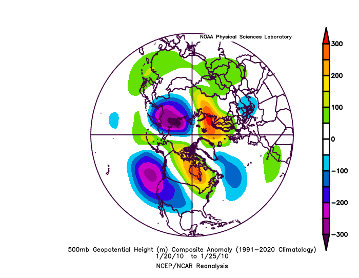
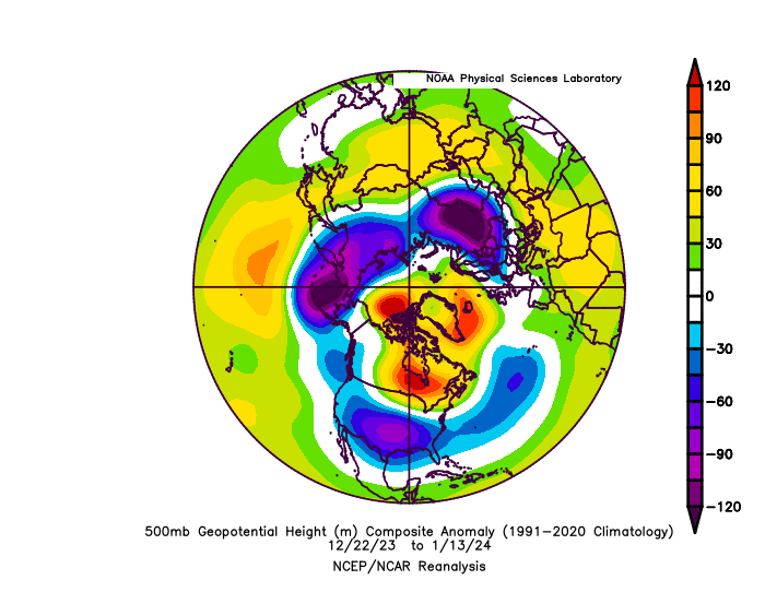
December did have more a canonical nino pattern, which is why early on I was still very optimistic for the winter despite the snowless early returns. The problem is in a strong nino December is typically warm/snowless anyways. The only exceptions are weaker or modoki nino's where the pacific trough is displaced west of normal for a nino and so we get a better PNA ridge. Even in the past it's always been difficult for us to overcome any deficiencies in the pacific until January. Our snowfall in December is more highly correlated to getting BOTH an ideal Atlantic High latitude AND pacific patterns. If you look at all the strong nino analogs even on the snowier side of the list...1958, 1966, 1987 and 2016, none had any snow in December except 1958 which had one fluke snowstorm in an otherwise torch month. The others were all snowless and warm. The issue is when the nino would have helped us it decoupled some in January. It ended up kind of a hybrid with both nino and nina tendencies. The stronger than normal ridging west of the nino trough was an issue. It continually pushed the nino trough east of ideal. The nino trough was NOT out of control like 1973 and 1998. It was not nearly the strength of a super nino trough. But it was displaced east so that it had the same impact on our pattern because of the nina like ridging further west in the pacific. We got a half and half winter, the problem is we got the worst half of both a nina and nino! Yay us. -

Late Feb/March Medium/Long Range Discussion
psuhoffman replied to WinterWxLuvr's topic in Mid Atlantic
And it induced this long wave pattern. The mjo can’t do anything about the fact the surface temps torched right through this period anyway.


