psuhoffman
-
Posts
27,419 -
Joined
-
Last visited
Content Type
Profiles
Blogs
Forums
American Weather
Media Demo
Store
Gallery
Everything posted by psuhoffman
-
IMO it depends on ability level. A-basin has some amazing expert level trees over on the Pallavicini side...but they are extremely challenging. Copper has some better trees for advanced intermediates to advanced but not true expert level. Winter park has the best IMO of the 3 resorts you mentioned. WP has really nice trees in between some of the trails on Mary Jane and especially under the Eagle Wind lift.
-

What Went Wrong in Winter 23-24/Base State/Will It Ever Snow Again??
psuhoffman replied to WxUSAF's topic in Mid Atlantic
That was as of a week ago...its been warm. But also, not sure if his data is the same, what I saw the NWS release might have included Alaska and Hawaii. -
@powderfreak or anyone else.... I'm pushing hard in rehap from a knee injury to try to get back out by Easter this season...but is there enough base at Subarbush, Stowe, and Sugarloaf for there to be a decent April ski season this year?
-
Late Feb/March Medium/Long Range Discussion
psuhoffman replied to WinterWxLuvr's topic in Mid Atlantic
I don't think the Wizards are going to win the championship this year -
Late Feb/March Medium/Long Range Discussion
psuhoffman replied to WinterWxLuvr's topic in Mid Atlantic
The pattern is changing... but I see some of the same flaws in the "better" pattern that has plagued us for years now even when we get a better longwave configuration. Add in the fact we are talking about late March and we're at the edge of when snow is even reasonably possible and that was before the current torch we've been stuck in for 9 years...I dunno man I am not saying the chances are 0. I realize crazy shit happens. Yes the pattern looks better. But by far the most likely outcome even if we do get a perfect track wave is just another perfect track rainstorm. Snowshoe probably gets a big snowstorm late March or early April. This probably saves the spring ski season for New England...but I am skeptical this does much for us locally. -
Late Feb/March Medium/Long Range Discussion
psuhoffman replied to WinterWxLuvr's topic in Mid Atlantic
I heard the winter of 1784BC was biblical and a strong analog -
What Went Wrong in Winter 23-24/Base State/Will It Ever Snow Again??
psuhoffman replied to WxUSAF's topic in Mid Atlantic
Yea, I am definitely NOT saying this is climate change. I don't know. But there has been very little discussion around this phenomenon at all, and that surprises me. I think because it's being written off as part of the larger PDO cycle. And a LARGE part of the western trough eastern ridge is most definitely related to the PDO. Yes the pacific has spend the vast majority of the time in a configuration that is conducive to a western trough eastern ridge longwave pattern. But there is variance within that. Just like we don't have an eastern trough 100% of the time in a positive PDO there is variability to the pacific pattern in a -PDO. The issue is I've noticed that during the perhaps 30% of the time where the pacific longwave pattern is not such that should amplify a trough in the west, about half that time it still is. Waves are coming in off the pacific and just wanting to amplify in the west regardless of what the upstream pattern is. I am just trying to flag this and start a conversation about it since I think this is part of what's making this period even worse than a typical -PDO cycle. I threw out 2 factors I can think of. The SER being fed not just by the western pattern but also by the warmer waters downstream could be offering some resistance...and stronger waves coming in off the pacific perhaps making it more likely they amplify sooner and then get stuck in the mountain west due to feedback there. Then you get an awful feedback loop between these 2 factors where the SER slows down the waves some which are already stronger and then they amplify more which pumps the ridge in front more...and UGH. But I have no idea if that is it. But no one else is even talking about it at all and offering other ideas. I am open to any ideas. I am not really open to the "this isn't actually happening" arguments because I've seen it too often. The waves obviously eventually come east...and its not happening all the time, yes sometimes we get a perfect EPO/PNA ridge that forces a huge trough into the east at times...but quite often even when the longwave configuration in the central and eastern pac would suggest waves should kick east before amplifying they are still amplifying more west first which pumps a ridge in front which means even when they do kick east its not going to work for us because there is too much heat in front of them. I see this...and I see no discussion about it which is frustrating because above all else I want to learn and understand. -
@jonjonCongrats, I've stopped in a couple times when I took the kids to Blackwater or Timberline but you weren't there...very nice place.
-
Late Feb/March Medium/Long Range Discussion
psuhoffman replied to WinterWxLuvr's topic in Mid Atlantic
-
Late Feb/March Medium/Long Range Discussion
psuhoffman replied to WinterWxLuvr's topic in Mid Atlantic
Here it is illustrated a different way. @brooklynwx99 Look at X and Y… it doesn’t matter Z is the same if ridge X trough Y equals trough Z AND trough X ridge Y STILL equals trough Z What pac long wave config doesn’t end up with a wave amplifying there??? or as @Ji said “what are we even doing here?” -
Late Feb/March Medium/Long Range Discussion
psuhoffman replied to WinterWxLuvr's topic in Mid Atlantic
We haven’t -
Late Feb/March Medium/Long Range Discussion
psuhoffman replied to WinterWxLuvr's topic in Mid Atlantic
Let me add to the last point…the waves will eventually progress east. But it doesn’t matter if they keep amplifying too much in the west FIRST and pumping heat ridges in front of them. -
Late Feb/March Medium/Long Range Discussion
psuhoffman replied to WinterWxLuvr's topic in Mid Atlantic
@brooklynwx99 @Ji @Terpeast This is an even better example of what I was talking about yesterday. This is before Ji’s “it has to be snow” wave. The ridging in front is the problem, ignoring the freaking crazy 50/50. But I get it there is a horrible air mass in front. So I’ll let that one go… Bit focus on the pacific and west coast progression here on this loop. That next wave should progress east. Look at the long wave pattern. That Ji wave is being absorbed into the 50/50 about to strengthen that. There is a perfect pac longewave configuration. But look what happened. Everything else in the pac progresses. The trough and ridge behind the wave move east. But the wave doesn’t. It’s dogging down and cutting off in the west and look it’s pumping another ridge ahead of it that’s going to link with the west based block and…we know the end. @brooklynwx99yesterday I showed this same thing on a gfs run and you said we just had to give it time and wait for the next wave to progress east but that was just an illusion because the run ended there. The next wave isn’t going to progress east either. The wavelengths in the west just adjust, broaden it shorten, as the waves amplify and get stuck in the west. I’m not interested in arguments if it’s happening. I’ve seen this time and again lately. I am interested in hypothesizing WHY that’s happening. The wavelengths to the west of these waves out west do not always support them digging into the west. But even when the pac pattern SHOULD kick the waves east the flow just compresses. My theory is that it’s not just the pac. That there is also downstream resistance in the flow. Maybe from the warmer than normal gulf and Atlantic. Also if the waves are coming in off the pacific more juiced up they could be amplifying sooner which could cause them to want to cut off in the mountain west due to feedback. I don’t KNOW. I’m just thinking wave physics and trying to figure out why something that shouldn’t based on the upstream wavelengths keeps happening. What’s weird to me is that no one else is talking about this. Just accepting it with no discussion of WHY! -
Late Feb/March Medium/Long Range Discussion
psuhoffman replied to WinterWxLuvr's topic in Mid Atlantic
It’s not even close but it has an absolutely perfect long wave pattern with a -nao and +pna which helps us get a 45* rainstorm instead of a 55* one!
-
What Went Wrong in Winter 23-24/Base State/Will It Ever Snow Again??
psuhoffman replied to WxUSAF's topic in Mid Atlantic
Daily https://psl.noaa.gov/data/composites/day/ monthly https://psl.noaa.gov/cgi-bin/data/composites/printpage.pl -
Late Feb/March Medium/Long Range Discussion
psuhoffman replied to WinterWxLuvr's topic in Mid Atlantic
Gonna rain -
Late Feb/March Medium/Long Range Discussion
psuhoffman replied to WinterWxLuvr's topic in Mid Atlantic
I’m tracking my April ski season in VT. Dunno what you’re doing. -
Late Feb/March Medium/Long Range Discussion
psuhoffman replied to WinterWxLuvr's topic in Mid Atlantic
We used to think the same thing about the poor schmucks in NC or SC that would track patterns and we knew even if everything went perfect it probably still wasn’t going to snow there. We’re those schmucks now. -
Late Feb/March Medium/Long Range Discussion
psuhoffman replied to WinterWxLuvr's topic in Mid Atlantic
@Ji even this isn’t enough to get snow even close to us. Other than above 3000 ft the snow is all north of the PA/NY line! -
The coldest high (not during a rainstorm) between April 15 and May 15 in 2019 was 62 degrees. Most days were in the 70s. I think the -NAO ruining our springs has been a bigger narrative than it has a reality.
-
Late Feb/March Medium/Long Range Discussion
psuhoffman replied to WinterWxLuvr's topic in Mid Atlantic
That run takes us through March 15. And the whole continent is still torched...it took 2 weeks to fix that problem in mid winter...what is your timeline here? -
But you are in CT, that's way different... its often 10-20 degrees colder there in the spring with backdoor cold fronts...we don't get those this far south. I am not complaining about a sunny 60 degree day, and that's about as bad as it gets due to blocking down here once past mid April.
-
The coldest day at BWI between April 15 and May 15 in 2022 that wasn't during precipitation was one day with a high of 58. The next coldest was a high of 60. Most of that month had highs in the 60's or 70s. There were several legit chilly days with highs in the upper 40s and low 50s but they were all days when it was raining. I don't care what the temp is in a rainstorm, I'm not outside anyways.
-
Late Feb/March Medium/Long Range Discussion
psuhoffman replied to WinterWxLuvr's topic in Mid Atlantic
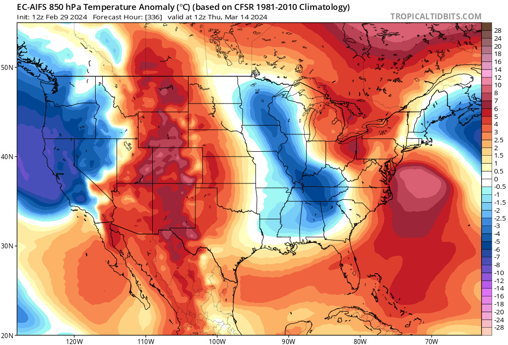
well it has a -NAO, MONSTER 50/50, perfect pacific, central pac trough, PNA ridge... just don't look at the temps TORCH lol #itjustdoesntmatter -
Late Feb/March Medium/Long Range Discussion
psuhoffman replied to WinterWxLuvr's topic in Mid Atlantic
Are you ok? Do you need help?