wthrmn654
-
Posts
3,953 -
Joined
-
Last visited
Content Type
Profiles
Blogs
Forums
American Weather
Media Demo
Store
Gallery
Everything posted by wthrmn654
-

Moderate snowfall 12/14/2025 WWA up for most of the area
wthrmn654 replied to WeatherGeek2025's topic in New York City Metro
Reading the last few pages will give anyone a headache jeez! -
Oh I sorry, I opened a can of worms with that question post I made earlier!
-
With the bad winters happening consistently lately, I can't remember how many years exactly so far now many other years has a similar outcome occurred based on record keeping stats? If rarely much at all, the big question that comes to mind is, will this be the new kind of winter we will be seeing from now on, with a warmer world?? Seems to me that part history versus what happens storms wise has been falling short. One example would be the forecasts for record breaking hurricane seasons the past 2 years falling a little short, with a couple monster storms... Or were simply stuck in a dam loop and can't seem to break it?
-
2 times now is been in the teens so far this December. 16 Friday morning and about 17 this morning. Surrounded by water with no wind, that's very very impressive for it only being beginning of December here on the island at the end..
-
Lots of outages on my area versus yesterday trees, wires, etc down all over the place
-
Rain stops and winds are increasing...
-
1.48 and winds have really picked up big time all sudden
-
1.42 dam that came down fast
-
A 39-year-old man died on Thursday after he became trapped in a flooded basement in Brooklyn, as sudden heavy, record-setting rains brought flash flooding to the New York area, the police said. A neighbor said the man who died had become trapped when he went back to his basement in the Flatbush neighborhood to rescue one of his dogs. A diver pulled him out, a Fire Department spokesman said. He was taken by ambulance to Kings County Hospital, where he died. Officials did not confirm whether his death was caused by flooding.
-
541 NWUS51 KOKX 310029 LSROKX Preliminary Local Storm Report National Weather Service New York NY 829 PM EDT Thu Oct 30 2025 ..TIME... ...EVENT... ...CITY LOCATION... ...LAT.LON... ..DATE... ....MAG.... ..COUNTY LOCATION..ST.. ...SOURCE.... ..REMARKS.. 0350 PM Flash Flood Bedford-Stuyvesant 40.69N 73.94W 10/30/2025 Kings NY Broadcast Media *** 1 FATAL *** Corrects previous flash flood report from Bedford-Stuyvesant. High standing water with water level above tires on some cars with leaf debris in water with time of occurrence estimated. One Fatality reported by FDNY.
-
Fatality reported by fdny.
-
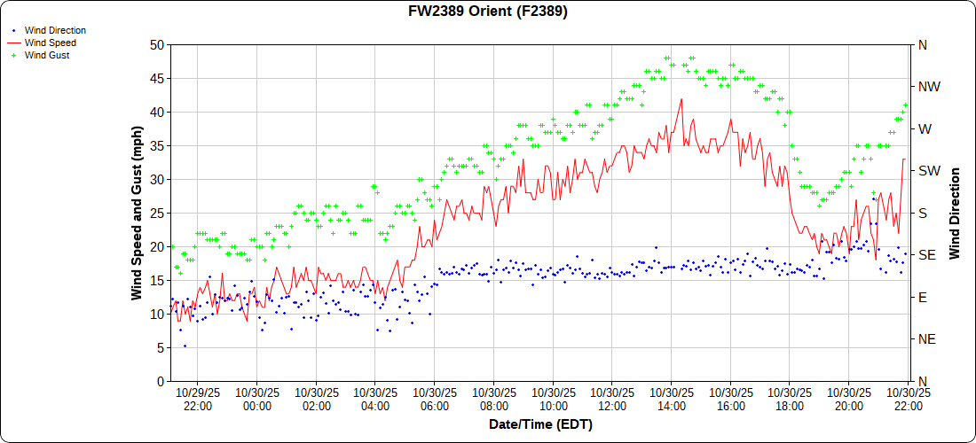
Man, if this is the style storms were going have this winter with s lot of wind before the storm and day of storm leading to higher tides, the beaches are not going make it.
-
Car stuck in 3 feet of water, but he called out a "puddle" in New Suffolk in cutchogue.
- 246 replies
-
- 1
-

-
- heavy rain
- damaging wind? squalls?
- (and 2 more)
-
0.92
-
0.65 with the monster rain all to come
-
Mesoscale Precipitation Discussion 1220 NWS Weather Prediction Center College Park MD 332 PM EDT Thu Oct 30 2025 Areas affected...northern NJ into southern NY/Long Island and CT Concerning...Heavy rainfall...Flash flooding possible Valid 301931Z - 310125Z Summary...Heavy rain across the Tri-State Area through this evening may result in localized flooding/flash flooding. Localized rainfall totals over 3 inches will be possible. Rainfall near 1 inch in 15-30 minutes can be expected. Discussion...19Z radar imagery showed a low-topped squall-line, oriented from south to north, edging east from 40 miles east of ACY through NYC. This line was being aided by strong low level convergence with 45-50 kt from the SSE/SE in the 925-850 mb layer, located north of the triple point of an occluded cyclone over the northern Mid-Atlantic region. The line of showers has been accompanied by 0.50 to 1.00 inches of rain in 15 minutes across northern NJ into the Five Boroughs. Moisture from the Mid-Atlantic coast into southern New England was already anomalous as sampled by area 12Z RAOBs, with PWAT values of 1.2 to 1.5 inches. However, OSPO's ALPW has since shown an increase stemming from Melissa's circulation, especially near and below 700 mb, being drawn northward into NJ and southern NY. The continued addition of this remnant tropical moisture should allow for an increase in rainfall efficiency and locally higher rainfall rate potential into the early evening hours. While the line of showers has been progressive, there is some concern for very brief slowing/stalling given the LEWP-like appearance off the NJ coast, which could result in a quick 1-2 inches as this line continues to advance east through the remainder of the afternoon. As a triple point low becomes better organized south of Long Island this evening, low level flow will maintain a southeasterly orientation, with possible backing. Therefore, some orographic component to lift will be added into the equation for the higher terrain north and west of I-95, combining with increasing right-entrance jet ascent associated with a forecast 130 kt jet streak on the east side of the parent upper low to the west. Farther south and west, instability is expected to remain weak (briefly peaking in the 500-1000 J/kg range) but perhaps sufficient to support a few additional heavy showers from eastern PA and southern NJ, rotating northward into the Tri-State region. Additional rainfall may result in isolated areas of rapid inundation of water. Given below average rainfall over the past few weeks and ongoing drought conditions across portions of the region, any flooding that occurs is likely to remain constrained to urban or other areas with poor drainage. Otto
- 246 replies
-
- 1
-
-
- heavy rain
- damaging wind? squalls?
- (and 2 more)
-
.HYDROLOGY... -- Changed Discussion -- Instantaneous rainfall rates with a narrow convective line moving through attm have come close to an inch in only 10 minutes in parts of NYC, with storm totals over 2 inches, causing flash flooding in spots. Widespread rainfall of 1.5-2.5 inches expected through tonight, with widespread nuisance flooding likely. Local amts as high as 3-4 inches, and rates up to an inch in less than an hour, will also present a localized flash flood risk mainly from western CT/Long Island north/west. -- End Changed Discussion --
- 246 replies
-
- 2
-
-
- heavy rain
- damaging wind? squalls?
- (and 2 more)
-
Flash flood warning
-
Special Weather Statement National Weather Service New York NY 225 PM EDT Thu Oct 30 2025 NJZ006-108-NYZ072-074-075-176>179-301915- Hudson NJ-Eastern Union NJ-Northern Queens NY-Southern Queens NY- New York (Manhattan) NY-Northern Nassau NY-Kings (Brooklyn) NY- Richmond (Staten Is.) NY-Southern Nassau NY- 225 PM EDT Thu Oct 30 2025 ...GUSTY SHOWERS WILL IMPACT HUDSON...SOUTHEASTERN UNION...QUEENS... RICHMOND...KINGS...NEW YORK (MANHATTAN) AND SOUTHWESTERN NASSAU COUNTIES THROUGH 315 PM EDT... At 224 PM EDT, Doppler radar was tracking gusty showers over Oakwood, or near The Verrazano Narrows Bridge, moving northeast at 35 mph. HAZARD...Wind gusts up to 50 mph. SOURCE...Radar indicated. IMPACT...Gusty winds could knock down tree limbs and blow around unsecured objects. This strong thunderstorm will be near... Coney Island and The Verrazano Narrows Bridge around 230 PM EDT. Flatbush around 235 PM EDT. Canarsie around 240 PM EDT. Howard Beach around 245 PM EDT. Rockaway Beach and Kennedy Airport around 250 PM EDT. Jamaica and Valley Stream around 255 PM EDT. Lynbrook and Elmont around 300 PM EDT. Garden City and Mineola around 305 PM EDT.
-
Sometimes I scratch my head with the NWS thinking
- 246 replies
-
- 1
-
-
- heavy rain
- damaging wind? squalls?
- (and 2 more)
-
Wind advisory now issued for Friday, not today
-
Per nws, there evaluating with an update shortly.
-
Power just went off then back on. Fairly quickly too weirdly enough